46 résultats
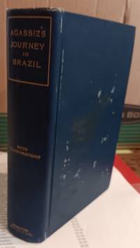
189562320<p>Boston: Houghton Mifflin and Company. Good with no dust jacket; Musty boards worn front boards spotted. 1895. Reprint. Hardcover. Navy cloth binding titled in gilt on spine. Top edges gilt xix 540pp engravings. Reprint of this 1867 title describing the natural history and collecting trip undertaken by the renowned naturalist and his wife to Brazil. ; 8vo 8" - 9" tall .</p> Houghton, Mifflin and Company hardcover
1849OB922<p>Boston: Benjamin B. Mussey & Co.; Uriah Hunt & Co. Philadelphia; M. W. Dodd NY 1849. Hard Cover. 333 p.; 20 cm. "The Review has far loftier object than those of the historical record. It aims to recommend and enforce the duty of preserving Peace by exhibiting the wickedness the baseness and the calamitous consequences of a victorious War." Sabin 35864. Bound in original blindstamped purple cloth gilt title on spine. Corners top & bottom of spine slightly worn minor splitting along top of front gutter some water discoloring to spine & edges of front and rear covers; scattered light foxing; Good. Stock#OB922.</p> Benjamin B. Mussey & Co.; Uriah Hunt & Co., Philadelphia; M. W. Dodd, NY,. hardcover
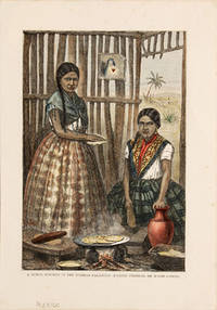
187052488c.1870. Scene showing woman cooking. Woodcut hand coloured In fine condition. unknown
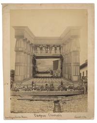
1890List1326Costa Rica 1890. Albumen photographs 9 x 7 ½ inches on larger mounts with credits to Rudd y Paynter and the Paynter Bros. Near Fine. H.N. Rudd and the Paynter Brothers Richard and John were photographers who were active in Costa Rica in the 1890s operating out of San Jose. Five of these views show the Rudd y Paynter mark on versos with their address at the Parque Central in San Jose. The Paynters were from the United States arriving in 1874 and first establishing Rudd y Paynter out of a shop in the Parque Central where they also sold marble and art objects. In 1895 the studio changed its name to Paynter Bros. <br /> <br /> Collected here are nine scarce albumen views of Costa Rica from the 1890s. Five of them document a trip up Mt. Turrialba these bear the Rudd y Paynter mark. Of the other other four one image shows a building likely in San Jose with a gathered crowd; one shows a very striking mural and is captured “Corpus Christi / Cartaga Costa Rica June 4 / 96 this shows no photographers mars though the size and format are identical to the others and we presume the photographers to be the Paynter brothers; One shows industrial coffee machinery on “El Canada†the last shows a group of people in front of the bridge over the Rio Grande with a platform showing the markings of the Hamlin Car and Wheel Company of Catwissa PA. The group with the exception of the Corpus Christi image are mounted on uniform heavy cardstock mounts with gilt edges and remain in particularly fine condition with excellent contrast and some light wear to mounts. Overall a scarce group documenting Costa Rica at a time when few photographers operated. unknown
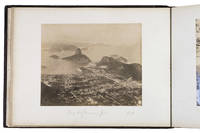
1885ABC_488551885. Contemporary gold-tooled dark purple quarter morocco brownish-purple pebble-grain cloth sides with a paper label "3" mounted on the front. Oblong ca. 38 x 27.5 cm. With 20 albumen prints 43 plates engraved and lithographed and 3 drawings. Remarkable album documenting the travels of HMS Calliope 1837-1883 a British warship in the first few years after her launch. The ship first sailed to Madeira and Tenerife after which she crossed the Atlantic Ocean to visit various harbour cities in Brazil Argentina Uruguay and Chile. Many of the illustrations and photographs include handwritten annotations about the ship's journey with the exact dates of when she arrived where. As such the album was likely compiled by someone who sailed on the ship during these years possibly a crew member. The album contains photographs drawings and plates relating to the places the Calliope visited between 1838-1840. It starts with photographs of Madeira and Tenerife like the Loo Rock in the harbour of Madeira locals carrying a tourist down the Pico Grande the town of Güímar in Tenerife and an age-old Dragon Tree. As the ship's next destination was Brazil the album contains a number of photographs and illustrations of Rio de Janeiro as well as a drawing of a picnic at the summit of the Corcovado. The Calliope then sailed to Buenos Aires and Santa Fe arriving in August 1838. This part of the album contains a drawing of a gaucho and 6 beautiful photographs by Samuel Boote 1844-1921 one of the most important photographers working in Argentina in the 19th century. His work shows the interior and exterior of the St. Felicitas Church in Santa Fe as well as daily life in this city. The ship then carried the British ambassador from Argentina to Montevideo arriving in June 1839 before continuing to Valparaíso. The final pages of the album contain a map of Montevideo views of Valparaíso and the mountains nearby and a drawing of a bridge.The plates in the album were taken from other works such as Journal of a voyage to Brazil 1824 by Maria Graham and A history of the Brazil 1821 by James Henderson. The photographs were taken in the 1880s which means the album must have been compiled several decades after this particular voyage of the Calliope. However as some of the annotations mention that a location looked different on the plate than when the Calliope arrived the album must have been compiled by a crew member.The Calliope sailed to China after the visit to Valparaíso to serve in the First Anglo-Chinese War 1839-1842. After she sailed to New Zealand and primarily operated in that region until she was converted into a floating chapel in 1855 and deconstructed in 1883. With the yellow bookseller's label of "A & N.C.S.Ld Stationery Dept. 105 Victoria St. S.W." mounted on the back pastedown. The leaves and plates are somewhat foxed likely lacking a plate or drawing on the recto of leaf 16. Otherwise in good condition. hardcover
186837791J. B. Lippincott Company. 1868. 1st U.S. Edition. Hardcover. Fair cover soil or toning a narrow 1 1/2 inch top rear edge strip worn down a top spine end small worn spot a surface scratch on the back page edges darkened. A solid sewn binding despite one signature being a bit pulled. Unmarked text. No dust jacket if issued. Green cloth with gilt spine lettering. This is an original edition not a recent reprint. ; 277 pages . J. B. Lippincott Company hardcover
18592221732<p>First edition. Octavo. 2 large folding tables at rear. Errata leaf. Contemporary maroon calf over marbled boards red morocco label minor rubbing. Very good. 65 pages XXVIII appendix.</p><p>Scarce work by this Mexican Lt. Colonel of Artillery 1831-1877. He achieved the rank of brigadier general and was appointed commander of the imperial artillery at the Siege of Queretara.</p><p>Provenance: From the library of the great English collector and bibliophile Sir Thomas Phillips 1792-1872 with his MS pressmark.</p> Imprenta de J. M. Lana hardcover
18512004AG1851. London & New York J & F. Tallis 1851. Original steel engraving / Vintage map. Drawn and engraved by John Rapkin. Partly hand-coloured. Plate Size: 23.9 cm x 34.3 cm. Sheet Size: 27.5 cm x 37.4 cm. Vintage 19th century map in very good condition. John Tallis 7 November 1817 3 June 1876 was an English cartographic publisher. His company John Tallis and Company published views maps and atlases in London from roughly 1838 to 1851. Tallis set up as a publisher with Frederick Tallis in Cripplegate in 1842; the business moved to Smithfield in 1846 and was dissolved in 1849. From 1851 to 1854 Tallis operated as John Tallis and Company. He started The illustrated news of the world and national portrait gallery of eminent personages in 1858 selling it for £1370 in 1861; it folded in 1863. Wikipedia The most important project John Tallis undertook was the 'Illustrated Atlas' from 1851. The original map we offer here was part of this exceptional Atlas and all the maps it contained are still today considered as the last reminder of an era of lavish map production. Tallis worked the project together with John Rapkin 1815-1876 and it was Rapkin's style and talent that we have to thank for when we marvel at these maps today. What makes these maps so special is the detail of engraved vignettes that surround the map and often show indigenous scenes people in their environment and even more so historical buildings or historical views of towns and cities architecture and landscape. The project of 'The Illustrated Atlas' was designed to be finished just in time for the anxiously awaited "Great Exhibition of the Works of Industry of All Nations" or The Great Exhibition sometimes referred to as the Crystal Palace Exhibition in reference to the temporary structure in which it was held was an international exhibition that took place in Hyde Park London from 1 May to 11 October 1851. It was the first in a series of World's Fairs exhibitions of culture and industry that became popular in the 19th century and it was a much anticipated event. The Great Exhibition was organized by Henry Cole and Prince Albert husband of the reigning monarch Queen Victoria. It was attended by numerous notable figures of the time including Charles Darwin Samuel Colt members of the Orléanist Royal Family and the writers Charlotte Brontë Charles Dickens Lewis Carroll George Eliot and Alfred Tennyson. Music for the opening was under the direction of Sir George Thomas Smart and the continuous music from the exhibited organs for the Queen's procession was "under the superintendence of William Sterndale Bennett". Wikipedia unknown
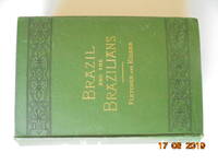
187916318Little Brown and Company 1879. Hardcover. Good/No DJ. Ninth edition. Revised and brought down to date." Page edges browned and foxed; extensive foxing of front endpapers especially frontispiece and facing title page despite protective rice paper transparency and again on the map facing first page of chapter one - fewer than ten pages are foxed but it is disheartening that it includes two sets of illustrations. There are 150 engravings in all. There is a three inch tear to the foldout map where it is attached to the page. On the verso of the front board is a former owner's bookplate. On the third front endpaper there is a 1886 gift inscription from Alencar Cintra to Colonel Henry B. Davenport. Binding is visibly rounded with rub marks on corners and spine tips otherwise the beveled decorative borders and gilt lettering on green cloth boards and spine are in very good plus condition. There is a three inch split at front pastedown gutter hinge emanating from the tail. <br/> <br/> Little, Brown, and Company hardcover
1883E0564Title leaf & 13 leaves of maps being mounted albumen photograph reductions of the original map. Photographs are approximately 7¼" x 8¾" on card stock leaves. Oblong royal octavo 9 "x 12½" bound in original red cloth rebacked with modern leather with original gilt-lettered leather spine laid on. References: P-LG 5121. El Territorio Mexicana Vol II p 457 reproduces 5th map of 1st edition. International Geographical Exposition and Congress of London. Geographical and Exploring Commission of the Mexican Republic. Catalogue of the Exhibits presented by the Commission with a short sketch of its organization and labors by the Directing Engineer Julio Alvarado C. E. Mexico 1895. p 32 First and only edition.<br /><br />Rare atlas of photographs of the map of the region around Puebla southwest of Mexico City. Warren Heckrotte describes the atlas and the enterprise that produced it: "The Comision Geografica-Explordora was established by a decree of December 13 1877. It was directed to prepare a map of the Republic with all the scientific accuracy desirable. The region around the town of Puebla southwest of Mexico City was the first effort of the Commission. The surveying was done by astronomical determinations and triangulation. Between 1879 and 1882 the planned nine sheets lithographed in Mexico City were issued at a scale of 1:20000. Elevations are shown by contour lines. For this atlas the sheets were issued as photographs the maps reduced in scale to 1:50000. A photographic edition at the scale of 1:100000 was also issued. Other areas of the country were mapped. The ultimate goal was to produce a map of the country at a scale of 1:100000 in 1100 sheets. At the time the Commission closed shop in 1914 a little over 200 sheets had been completed. This mode of production suggests that a small number of these atlases were produced." Indeed OCLC/WorldCat locates only two copies at the University of California Berkeley and Dartmouth College.<br /><br />Condition:<br /><br />Some soiling to covers; expertly rebacked by Sandra Good; new endpapers; internally fine or nearly so a bit of darkening to margins of mounts. Comisión Geográfico-Exploradora hardcover
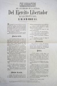
1872List1815Guatemala City 1872. Broadside measuring 17 ¼ x 13 ½ inches. Vertical fold to center some loss and foxing to left upper portion very good plus overall. An unrecorded broadside announcing the first celebration of the Día del Ejército de Guatemala a holiday celebrating the defeat of the dictator Vicente Perna. This broadside also mentions the success of the campaign in Honduras as a reason for the celebration. The text gives an extensive description of the day’s festivities with celebrations including the military band and a puppet theater for children. The rules for the evening include no selling of alcoholic beverages and no one entering the plaza on horseback. The holiday still exists today and became a center of controversy following the Guatemalan Civil War. unknown
18512010AG1851. London & New York J & F. Tallis 1851. Original steel engraving / Vintage map. Drawn and engraved by John Rapkin. Partly hand-coloured. Plate Size: 32.4 cm x 27.3 cm. Sheet Size: 37.5 cm x 27.4 cm. Vintage 19th century map in very good condition. John Tallis 7 November 1817 3 June 1876 was an English cartographic publisher. His company John Tallis and Company published views maps and atlases in London from roughly 1838 to 1851. Tallis set up as a publisher with Frederick Tallis in Cripplegate in 1842; the business moved to Smithfield in 1846 and was dissolved in 1849. From 1851 to 1854 Tallis operated as John Tallis and Company. He started The illustrated news of the world and national portrait gallery of eminent personages in 1858 selling it for £1370 in 1861; it folded in 1863. Wikipedia The most important project John Tallis undertook was the 'Illustrated Atlas' from 1851. The original map we offer here was part of this exceptional Atlas and all the maps it contained are still today considered as the last reminder of an era of lavish map production. Tallis worked the project together with John Rapkin 1815-1876 and it was Rapkin's style and talent that we have to thank for when we marvel at these maps today. What makes these maps so special is the detail of engraved vignettes that surround the map and often show indigenous scenes people in their environment and even more so historical buildings or historical views of towns and cities architecture and landscape. The project of 'The Illustrated Atlas' was designed to be finished just in time for the anxiously awaited "Great Exhibition of the Works of Industry of All Nations" or The Great Exhibition sometimes referred to as the Crystal Palace Exhibition in reference to the temporary structure in which it was held was an international exhibition that took place in Hyde Park London from 1 May to 11 October 1851. It was the first in a series of World's Fairs exhibitions of culture and industry that became popular in the 19th century and it was a much anticipated event. The Great Exhibition was organized by Henry Cole and Prince Albert husband of the reigning monarch Queen Victoria. It was attended by numerous notable figures of the time including Charles Darwin Samuel Colt members of the Orléanist Royal Family and the writers Charlotte Brontë Charles Dickens Lewis Carroll George Eliot and Alfred Tennyson. Music for the opening was under the direction of Sir George Thomas Smart and the continuous music from the exhibited organs for the Queen's procession was "under the superintendence of William Sterndale Bennett". Wikipedia unknown
1882CA0128xv488 pages with appendices. Octavo 8 1/2" x 5" bound in quarter leather with gilt lettering to spine in stiff boards. From the library of Professor George M Foster. Second edition.<br /><br />Alonso de la Rea was born in Queretaro in 1610. He wrote his Cronica in 1637-1639 providing data on Michoacán and Jalisco. For many matters he leaned heavily on Torquemada who in turn had copied them from Mendieta. Ricard quoting an 18th century opinion mentions that Rea lacked interest in chronology to an excessive degree. His work was however an official and methodical chronicle of the province preserving considerable detail about it. Rea's Cronica . 1639 was first published in 1643 and is now a bibliographical rarity. The volume is divided into three books totaling 92 chapter. Book 1 describes the region products people their dealings with Aztecs their general traits religious rites the last native emperors and coming of the Spaniards. This is followed by arrival of the Franciscan missionaries with biographies of some of these pioneer friars. Book 2 begins with the division of the province between Michoacán and Jalisco 1606 and contains numerous biographies of the members of that order. Book 3 is also a series of lives and an account of the Custodio del Rio Verde. The second edition was published in Mexico 1882. It includes additional relevant documents in three appendices. At the end of the text there is a table of contents but no index.<br /><br />George McClelland Foster Jr born in Sioux Falls South Dakota on October 9 1913 died on May 18 2006 at his home in the hills above the campus of the University of California Berkeley where he served as a professor from 1953 to his retirement in 1979 when he became professor emeritus. His contributions to anthropological theory and practice still challenge us; in more than 300 publications his writings encompass a wide diversity of topics including acculturation long-term fieldwork peasant economies pottery making public health social structure symbolic systems technological change theories of illness and wellness humoral medicine in Latin America and worldview. The quantity quality and long-term value of his scholarly work led to his election to the National Academy of Sciences in 1976. Virtually all of his major publications have been reprinted and/or translated. Provenance from the executor of Foster's library laid in.<br /><br />Condition:<br /><br />Foster's stamp to title. Corners bumped edge wear to boards rubbing to paper boards else a very good copy. Imprenta de J R Barbedillo hardcover
1826100363Editions Elisée Aubanel - Tarascon 1826. Bonded Leather. <b>Livre en français</b>. Couverture rigide. Reliure pleine basane frottée trous de ver coiffes usées. 443 pages. <i>ref. 100363</i> Editions Elisée Aubanel - Tarascon hardcover
18250006996Edinburgh: Archibald Constable 1825. Fourth edition Revised and Enlarged . Hardcover. Very Good. Duodecimos; xx 379; xii 320 80 pages contemporary quarter calf marbled boards tips of spines worn tight scuffed boards. Lacks the frontispiece chart in vol.1. Light tidal marks on endpapers bookplate front hinge of vol. 1 and heel chips repaired. <br/><br/>These chapters have been re-ordered. The chapter on the Mexican Revolution is enlarged with an account of the death of Iturbide the ex-Emperor. The treatment of the Spanish Colonial System is corrected and enlarged. There is additional material about the climate of South America and diseases supplied by George Birnie Surgeon of The Conway. Several new Extracts have been added plus additions to the Appendix. Archibald Constable hardcover
1806ALEX139Impensis by S. F. Bradford Philadelphia: 1806 1806 561 p. i.e. 571 p. Various pagination. Double column. Text in Greek and Latin. Early manuscript ownership of Samuel Helffenstein 1775-1866. Also Peter Plug 1816 and J.N. Wagner. Crude pencil drawings on rear fly leaves. Text beginning to brown but not brittle. 12mo. 185 mm. Original full leather binding scuffed and worn. Original leather spine label. Loss at head of spine. Hardbound. Good. Helffenstein was Elected as minister of the Pennsylvania Bible Society in 1799 and served as a manager of the Bible Society from 1808-1854. The Society probably sponsored this Greek/Latin Edition. He was pastor of the First Reformed Church St. Peter's German Reformed in Philadelphia. His father - Rev. John Christian Albert Helfenstein was a minister of the German Reformed Congregation in Germantown. S&S/AI 9974. First American Edition of a Greek & Latin New Testament. SCARCE. Apparently not listed for sale on-line anywhere. PRICE JUST REDUCED! PAIMP 10. 1st Edition. Hardcover. Good. Impensis by S. F. Bradford, Philadelphia: 1806 hardcover
1879072645Geneva: Titus Tobler & Augustus Molinier 1879. Very Good. LATIN TEXT. VOLUME I. Publication of the Society of the Latin Orient Geographical Series. Title translated: "Jerusalem and Descriptions of the Holy Land before The ancient Latin language was Destroyed by the Sacred wars at the Expense of Society". lv Preface. Sections titled Journey Holy Places Overseas Sacred Places Index of Readings 418 pp. <br><br>CONDITION: Half bound marbled boards gilt title within label on brown leather spine. Wear to edges corners and covers. Tightly bound cracked front hinge. Ex library stamps on pastedown with sticker front endpaper rear endpaper and occasionally throughout. Foxing on page edges and mildly on the interior. No writing within. Very good. Full refund if not satisfied. Titus Tobler & Augustus Molinier hardcover
18950007511895. 2nd Edition. Hardcover. Rare item of Historical importance to the history of Venezuela and the Spanish speaking world. 582pp Covers detached from text - which is still tightly bound and clean. Protected by polythene covers. Signed by the author in the front. <br /><br /> Tipografía Artística Mijares, hardcover
185140499Boston: Charles C. Little and James Brown. Good with no dust jacket; Boards have minor wear owner bookplates Fanny . Hazard Bond on front pastedowns foxing musty. 1851. Eighth Edition. Hardcover. Xxxiv 488 pp 509 pp 531 pp. All three volumes uniformly bound in three-quarter dark brown pebbled leather with marbled sides and matching endpapers. Four raised bands on each spine with titles stamped in gilt. Top edges gilt. Each volume contains a frontispiece engraving Hernando Cortes Montezuma with tissue guard. Map of Mexico in Volume One. The 1843 first edition of this title was Number 51in the Grolier Club's 1946 exhibition and publication One Hundred Influential American Books Printed Before 1900. ; 8vo 8" - 9" tall . Charles C. Little and James Brown hardcover
1855240500New York: Gurdon Bill 1855. New edition. Hardcover. poor. 8vo; 1-636 ii 639- 640 pages - the last page is mistakenly numbered 702 contemporary black leather covers effectively disbound. <br/><br/>An intriguing compilation illustrated with 40 portraits and plates most hand-colored six or so in black-and-white and half a dozen of animals such as an eagle bison grizzly bear black squirrel cougar and portraits of Tecumseh Joseph Brant King Philip John Smith Osceola Samoset and more. Note: the verso of p. 639 reads p.720 but should be 640. Sabin 8681. Note: Field in his INDIAN BIBLIOGRAPHY pp. 49-50 of the 1857 edition opined "The last half of the title-page must have been written by the publisher and the illustrations drawn by his infant son as the Preface and Text indicate too respectable a mind to have concocted such a farrago involving at least half a dozen falsehoods regarding the plates which are the most tawdry and offensive daubs." Field continued "The work is fairly executed and contains much condensed information . . " Bennett's AMERICAN COLOR PLATE BOOKS 1800-1900 lists the later 1856 edition and as having only 34 full-page plates. Gurdon Bill hardcover
18530008336Boston: Horace Wentworth 1853. New edition. Hardcover. Good. 8vo; 1-636 ii 639- 640 pages - the last page is mistakenly numbered 702 contemporary black leather covers newly rebacked saving as much of the original spine as possible new endpapers. <br/><br/>An intriguing compilation illustrated with 40 portraits and plates most hand-colored six or so in black-and-white and half a dozen of animals such as an eagle bison grizzly bear black squirrel cougar and portraits of Teumseh Joseph Brant King Philip John Smith Osceola Samoset and more. Note: the verso of p. 639 reads p.720 but should be 640. Sabin 8681. Note: Field in his INDIAN BIBLIOGRAPHY pp. 49-50 of the 1857 edition opined "The last half of the title-page must have been written by the publisher and the illustrations drawn by his infant son as the Preface and Text indicate too respectable a mind to have concocted such a farrago involving at least half a dozen falsehoods regarding the plates which are the most tawdry and offensive daubs." Field continued "The work is fairly executed and contains much condensed information . . " Bennett's AMERICAN COLOR PLATE BOOKS 1800-1900 lists the later 1856 edition and as having only 34 full-page plates. Horace Wentworth hardcover
18512009AG1851. London & New York J & F. Tallis 1851. Original steel engraving / Vintage map. Drawn and engraved by John Rapkin. Partly hand-coloured. Plate Size: 33.2 cm x 24.6 cm. Sheet Size: 37.5 cm x 27.3 cm. Vintage 19th century map in very good condition. John Tallis 7 November 1817 3 June 1876 was an English cartographic publisher. His company John Tallis and Company published views maps and atlases in London from roughly 1838 to 1851. Tallis set up as a publisher with Frederick Tallis in Cripplegate in 1842; the business moved to Smithfield in 1846 and was dissolved in 1849. From 1851 to 1854 Tallis operated as John Tallis and Company. He started The illustrated news of the world and national portrait gallery of eminent personages in 1858 selling it for £1370 in 1861; it folded in 1863. Wikipedia The most important project John Tallis undertook was the 'Illustrated Atlas' from 1851. The original map we offer here was part of this exceptional Atlas and all the maps it contained are still today considered as the last reminder of an era of lavish map production. Tallis worked the project together with John Rapkin 1815-1876 and it was Rapkin's style and talent that we have to thank for when we marvel at these maps today. What makes these maps so special is the detail of engraved vignettes that surround the map and often show indigenous scenes people in their environment and even more so historical buildings or historical views of towns and cities architecture and landscape. The project of 'The Illustrated Atlas' was designed to be finished just in time for the anxiously awaited "Great Exhibition of the Works of Industry of All Nations" or The Great Exhibition sometimes referred to as the Crystal Palace Exhibition in reference to the temporary structure in which it was held was an international exhibition that took place in Hyde Park London from 1 May to 11 October 1851. It was the first in a series of World's Fairs exhibitions of culture and industry that became popular in the 19th century and it was a much anticipated event. The Great Exhibition was organized by Henry Cole and Prince Albert husband of the reigning monarch Queen Victoria. It was attended by numerous notable figures of the time including Charles Darwin Samuel Colt members of the Orléanist Royal Family and the writers Charlotte Brontë Charles Dickens Lewis Carroll George Eliot and Alfred Tennyson. Music for the opening was under the direction of Sir George Thomas Smart and the continuous music from the exhibited organs for the Queen's procession was "under the superintendence of William Sterndale Bennett". Wikipedia unknown
18528235London. Samuel Bagster. 1852. Bound in full blind ruled morocco. Blind ruled spine compartments with raised bands. Gilt titles. a.e.g. 32mo 2" x 3.5". A bit of rubbing to extremities. A Near Fine crisp sweet little copy. Samuel Bagster. hardcover
18290005575Boston: Bowles and Dearborn 1829. First edition. Hardcover. Good. Octavo xv 256pp. original quarter linen & boards untrimmed 250mm x 145mm chipped paper label on spine shaken inked name on free endpaper needs some resewing. <br/><br/>Rev. Abbot went to Cuba to restore his fragile health. This eloquent Harvard graduate then traversed a thousand miles on horseback through Sumidero and Lemonal Matanzas a week in Havana etc. "The pictures he has given are of things which were immediately before him as exact in circumstances and as true to the life as his pencil could pourtray; and the statement of facts is correct according to his convictions - Preface." Sabin 14; Palau 519; Shaw & Shoemaker 37345. Abbot died on his return trip before reaching his Massachusetts home. Bowles and Dearborn hardcover
183581555Taurini Turin:: Ex Regio Typographeo 1835. First edition. 19th c. quarter calf and marbled boards. 1855 ink gift inscription at head of title page; some scattered light and inoffensive foxing; binding rubbed and a little worn; upper joint cracked but cords holding. Folio. Ex Regio Typographeo, hardcover