SANSON, NicolasBiblio.com

53 résultats
1723202384Amsterdam: Mortier Pieter II 1723. unbound. very good. Map. Engraving with hand coloring. Image measures 14.5" x 19.25".<br/> <br/> Includes parts of modern day Morocco Algeria Tunisia and Libya. Nicolas Sanson 1600-1667 is considered the founder of the French school of cartography. In reaction to the prevailing trend of Dutch lavishness Sanson favored minimal details focusing rather on accurate cartography than ornament. Large decorative title cartouche. Map is in good condition with ample margins. Staining along centerfold. Chipped near edges along centerfold.<br/> <br/> Mortier, Pieter II unknown
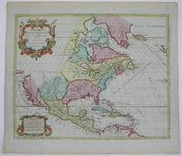
1792M4892Amsterdam 1792. Excellent. Notes: North America revised from the Sanson/Jaillot maps. California is shown as a peninsula but named "isle de California" to the northwest is "Mer de Iesso" and beyond that a small stretch of coastline "Terre de Iesso ou Ieco." The Great Lakes are defined if not with great accuracy a number of settlements in Nouveau Mexico are identified and a R. del Norte flows southwest from a large lake near Taosii to the Gulf of California. Size : 480x580 mm 18.875x22.875 Inches Coloring: Original Hand Coloring Category: Maps North America; Maps Central America; Maps West Indies General unknown
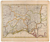
1710009141Amsterdam: Pierre Mortier 1710 Cooper engraving 44.5 x 59.5 cm on paper measuring 54.0 x 64.0 cm with original color in outline minor spotting and creasing remnants of centerfold. A good copy of a map of south-central France the Cévennes Vivarais Occitania published in Amsterdam by Pierre Mortier to illustrate events of the War of the Spanish Succession. Pierre Mortier unknown