181 résultats
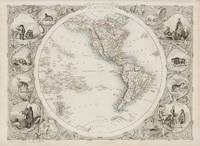
1851200121AG1851. London Edinburgh & Dublin J.& F. Tallis 1851. Original steel engraving / Vintage map. Drawn and engraved by John Rapkin. Partly hand-coloured. Illustrations by H. Warren and Enrgaved by J. Rogers. Plate Size: 34 cm x 25.5 cm. Sheet Size: 37.4 cm x 27 cm. In very good condition with only faintest traces of browning to outer margins. Very slight paper imperfections along edge. Minor tear near upper left corner. Very minor tear to map above the Arctic Circle. Published in the Illustrated Atlas And Modern History Of The World Geographical Political Commercial & Statistical Edited By R. Montgomery Martin. Beautifully bordered and fascinating map of the western hemisphere including North and South America. The Azores and Cape Verde islands and the Caribbean islands are included in the Atlantic Ocean. In the south South Shetland Islands and South Victoria populate a blank area where the Antarctic ought to be found. In the Pacific New Zealand and the Polynesian and Sandwich Hawaiian islands. To the north the end of Asia can be seen and across the Arctic Ocean Greenland is also included. The political divisions are colourfully delineated. Interestingly Alaska is described as 'Russian America' highlighting that the U.S. had still to purchase "Seward's Icebox" from the Tsar when the map was published. John Tallis 7 November 1817 3 June 1876 was an English cartographic publisher. His company John Tallis and Company published views maps and atlases in London from roughly 1838 to 1851. Tallis set up as a publisher with Frederick Tallis in Cripplegate in 1842; the business moved to Smithfield in 1846 and was dissolved in 1849. From 1851 to 1854 Tallis operated as John Tallis and Company. He started The illustrated news of the world and national portrait gallery of eminent personages in 1858 selling it for £1370 in 1861; it folded in 1863. Wikipedia The most important project John Tallis undertook was the 'Illustrated Atlas' from 1851. The original map we offer here was part of this exceptional Atlas and all the maps it contained are still today considered as the last reminder of an era of lavish map production. Tallis worked the project together with John Rapkin 1815-1876 and it was Rapkin's style and talent that we have to thank for when we marvel at these maps today. What makes these maps so special is the detail of engraved vignettes that surround the map and often show indigenous scenes people in their environment and even more so historical buildings or historical views of towns and cities architecture and landscape. The project of 'The Illustrated Atlas' was designed to be finished just in time for the anxiously awaited "Great Exhibition of the Works of Industry of All Nations" or The Great Exhibition sometimes referred to as the Crystal Palace Exhibition in reference to the temporary structure in which it was held was an international exhibition that took place in Hyde Park London from 1 May to 11 October 1851. It was the first in a series of World's Fairs exhibitions of culture and industry that became popular in the 19th century and it was a much-anticipated event. The Great Exhibition was organized by Henry Cole and Prince Albert husband of the reigning monarch Queen Victoria. It was attended by numerous notable figures of the time including Charles Darwin Samuel Colt members of the Orléanist Royal Family and the writers Charlotte Brontë Charles Dickens Lewis Carroll George Eliot and Alfred Tennyson. Music for the opening was under the direction of Sir George Thomas Smart and the continuous music from the exhibited organs for the Queen's procession was "under the superintendence of William Sterndale Bennett". Wikipedia unknown
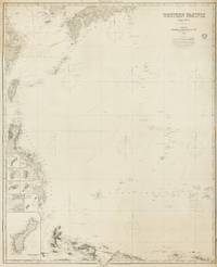
1884143681London: James Imray and Son 1884. Very Good. London James Imray and Son 1884. A very large engraved chart printed on two sheets combined printed surface 1268 × 1015 mm overall total size 1280 × 1048 mm mounted on the original blue backing paper with the publisher's title-label on the verso. Chips and short tears to the margins in a few places clear of the printed surface; a few small light stains and other minor signs of age and handling; in very good condition with faint pencil annotations tracking a voyage to Hangzhou in September 1888. A very large and detailed blueback chart of the western rim of the Pacific Ocean including the East China Sea Philippine Sea and parts of the coastlines of Japan Korea China Taiwan the Philippines and New Guinea. It features eight inset charts: Guajan Island; Borodino Island; Umata Bay; Farralon de Medinilla; Rota; Alamagan; Guguan; and Rosario Island. Both sheets incorporate corrections to June 1884. <p>The title-label on the verso reads 'Chart No 193. Western Pacific in Seven Charts. Chart No. 4. Price 8s.'. James Imray and Son unknown
1887038377New York: American Bank Note Co 1887. First Edition. Very Good. Broadsheet printed in black ink on buff stock opens to 12.25" x 25.5". Includes an inset map 5.75" x 8.75" and a long paragraph of text on Chautauqua Lake. Folds to 6" x 3.25" with different illustrations of Niagara Falls on both cover panels. Dated "August 21 1887. Corrected to Sept. 18." Not found in OCLC nor WorldCat. American Bank Note Co unknown
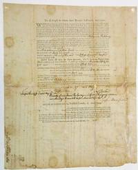
180533731Fairfield County 1805. Broadsheet 12-1/2" x 15-1/2". Printed document completed in ink manuscript. Old folds with some repaired splits and one 6" unrepaired split. Some small chips along a few splits with minimal loss. Light tanning scattered spotting. Good. <br /> <br /> The original grant for this land was to Nehemiah Phippeny who lost title for nonpayment of taxes. The land was sold to Lothrop Lewis of Fairfield Connecticut on May 27 1805. On the verso are hand written transfers of the same piece of property: from Lothrop Lewis to William Hawley of Woodbury January 21 1806; from Hawley to Nehemiah Dibble of Stamford February 7 1806; from Dibble to Zalmon & Seymour Wildman of Danbury October 20 1806. There is also a voided transaction crossed out from Hawley to William Lamson of Waterbury January 31 1806. <br /> In 1800 the State of Connecticut granted to her citizens who were sufferers by fire caused by the British during the Revolutionary War a half million acres of land lying within the State of Ohio which was to be taken off the west part of the "Western Connecticut Reserve" now embraced in the counties of Huron and Erie. By an 1803 Act of Ohio the sufferers were incorporated as "The proprietors of the half million acres of land lying south of Lake Erie called 'Sufferers' Land'." The Act required management of the Company by a Board of Directors. The Board was to locate and survey the granted land and to partition it among the different claimants. This part of the Western Reserve was inhabited by Indians who engaged in warfare with the settlers. On July 4 1805 a treaty between the United States and the Wyandot Ottawa Chippewa Munsee and Delaware Shawanee and Pattawatamy nations was signed whereby those Indian nations in consideration of $18916.68 released their claims to all the lands owned by the company. unknown
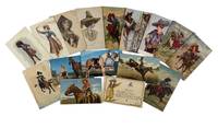
1890212421890. Archive of postcards documenting the popular image of the American cowgirl in Western Americana and early twentieth-century mass visual culture. Working in Cultural / Representational Mode the material illustrates how women participating in rodeo performance equestrian spectacle and frontier-themed entertainment were presented to national audiences during a period when women's public roles remained heavily circumscribed by conventional gender expectations. The postcards emphasize physical skill horseback mobility and frontier self-sufficiency through repeated depictions of women handling lassos firearms and bucking horses. Collectively the archive offers insight into the commercialization of the American West and the circulation of gendered frontier mythology through inexpensive illustrated print media from the late nineteenth century through the postwar period.<br /> Collection consists of 16 postcards dating approximately from the 1890s through the 1950s including early colored lithographs chromolithographs and colored real photo postcards. Each measures approximately 3.5 x 5.25 inches. Images portray cowgirls mounted on horseback in a variety of staged action scenes including lasso throwing galloping bucking and trick riding performances. Many women wear fitted riding outfits cowboy hats bandoliers holsters and western boots while posed with rifles pistols whips or ropes against rugged frontier backdrops. Several postcards emphasize dramatic movement with horses shown rearing trotting or in mid-action poses. The repeated use of lassos and firearms visually aligns the women with iconography traditionally associated with male cowboys in Wild West shows rodeo advertising and popular Western entertainment. Some postcards retain handwritten inscriptions on the versos.<br /> The archive preserves a long-running commercial visual tradition in which the cowgirl functioned simultaneously as frontier worker entertainer and symbol of female independence within American popular culture. Particularly notable is the tension between conventional femininity and the rugged physicality emphasized throughout the imagery with the women consistently portrayed as active riders and performers rather than domestic figures. The postcards also document the persistence of Western mythology across changing photographic and print technologies during the first half of the twentieth century. Minor edgewear and scattered markings to some cards; overall very good condition. A visually cohesive grouping documenting representations of women in frontier and rodeo culture across more than five decades of American postcard production. unknown
1868167531868. Women's Education Movement. Western Female Seminary Catalog 1868-1869. Oxford OH. Western Female Seminary was founded in 1853 as a daughter school of Mount Holyoke College in South Hadley Massachusetts. Its first principal Helen Peabody and most of the early faculty had been students and teachers at Mount Holyoke. Mary Lyon Residence Hall on the Western campus is named for Mount Holyok's founder Mary Lyon. It later received a charter and became Western College an all-female institution. Women's colleges proliferated in the mid- to late- 19th century to fill the void created by their exclusion from most institutions of higher education. The prevailing notion that women were too delicate for a rigorous academic education was openly challenged when Elizabeth Cady Stanton spoke at the Seneca Falls Convention of 1848 "Man's intellectual superiority cannot be a question until woman has had a fair trial.When we shall have had our colleges our professions our trades for a century a comparison then may be justly instituted." Young women were quick to step up to the challenge; as quickly as female colleges opened they filled up. At the time that this description is being written no copies are recorded in American institutions. OCLC search results are at best an estimate and can vary over time.<br /> <br /> Women's Academy and Seminary Archive recording the first important movement of women into higher education in the United States seminary was synonymous with "academy" and did not have the religious connotation of today. In the 1800's the Female Academy and Seminary Movement transformed American educational norms allowing women the opportunity to receive secular non-religious college-level education. Women's colleges proliferated in the mid- to late- 19th century to fill the void created by their exclusion from most institutions of higher education. The prevailing notion that women were too delicate for a rigorous academic education was openly challenged when Elizabeth Cady Stanton spoke at the Seneca Falls Convention of 1848 "Man's intellectual superiority cannot be a question until woman has had a fair trial.When we shall have had our colleges our professions our trades for a century a comparison then may be justly instituted." Young women were quick to step up to the challenge; as quickly as female colleges opened they filled up. unknown