[Russia]Biblio.com

2 résultats
1698112625London: R. Baldwin 1698. First edition of this work. Octavo bound in modern wrappers 28 pages. In very good condition with some browning and toning to the text. Rare with no other examples appearing at auction in the last 80 years. R. Baldwin unknown
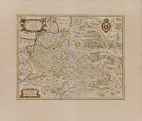
1664200038AG1664. Amsterdam Blaeu c.1664. Original hand-coloured engraving. Plate Size: 48.7 cm x 38.6 cm. Sheet Size: 65.2 cm x 55.7 cm. Original map. In very good clean condition. Wide margins. Latin text on reverse. Koeman II 1803:2. From: J. Blaeus Grooten Atlas oft Werelt- Beschryving in welcke 't Aerdryck de Zee en Hemel wort vertoont en beschreven. Amsterdam J. Blaeu 1664. Van der Krogt 2 621. Beautiful map of mid-17th Century Russia published during the reign of Tsar Alexis of Russia of the Romanov Dynasty as Moscow vied for regional hegemony with the PolishLithuanian Commonwealth and Sweden. 'Mosqua' Moscow is in the lower right corner. Smolesnsk is just squeezed in within the maps lower border. Novogorod can be seen just below the outflow of Lake Ilmen. In the upper left lies Estonia and the Gulf of Finland. Below this is the 'Livonia' region which is now between Latvia and Estonia. The regions listed as 'Ingria' and 'Careliae Pars' on the map were then under the control of the Swedes. The Russians would eventually seize this territory and dominance of the Baltic and build their new capital St. Petersburg there. This lay in the future. The map's political delineation shows the westward extent of Moscow's reach. 'Lithva' in the lower left of the map was then within the territory of Polish-Lithuanian Commonwealth. This region is now modern-day Belarus: 'Witespk' is now the Belarussian city of Viciebsk. Relief depicted pictorially and the historic place-names are in Latin. The cathedral cities such as Pereslaw Pereslavl-Zalessky and Ieroslaw Yaroslavl and Pseskow/Pskouwa Pskov are depicted. With numerous deers and foxes seen across the map the mapmaker indicates that this is a vast region still untamed. In the 'Megrina' province the mapmaker shows a bear-hunt at its deadly denouement. The map is covered with forested areas and vast waterways such as the Volga and Volkhov and Daugava/Dvina 'Duna flu' Dnieper Boristenis Flu rivers and a patchwork of lakes such as Lake Peipus and 'Biela Osera' Rybinsk Reservoir. Large decorative title cartouche accompanied with busts of moose and deer in the left top corner of the map. The eagles of the Russian coat of arms look east and west from the top right corner of the map. In the lower left corner an ornate cartouche contains two milliaria bar scales. Blaeu as it is noted on the cartouche based the map on the travels and maps of Isaac Massa. Isaac Abrahamszoon Massa 1586 - 1643 was a Dutch grain trader traveller and diplomat the envoy to Muscovy. He wrote memoirs related to the Time of Troubles and created some of the earliest maps of Eastern Europe and Siberia. Massa in Moscow witnessed the second half of Boris Godunov's reign during which a civil war broke out now known as the Time of Troubles. He survived the capture of Moscow by False Dmitriy I and left Russia in 1609 before the fall of Tsar Vasily Shuysky. Massa compiled an account of the 16011609 events Dutch: Een cort Verhael van Begin en Oorspronk deser tegenwoordighe Oorloogen en troeblen in Moscovia totten jare 1610 which he presented to Stadtholder Maurice. In 16121613 Massa published two articles on Russian events and the geography of the Land of Samoyeds accompanied by a map of Russia which were published in an almanac edited by Hessel Gerritsz. His notes on his various travels have been published in conjunction with maps made by the explorer Henry Hudson. Massa is credited with five published maps of Russia and its provinces the last ones compiled around 1633 and two maps of Moscow city including the schematic account of the 1606 battle between Vasily Shuysky and Ivan Bolotnikov's armies. He returned to Russia in 1614 and became an active agent in a myriad of diplomatic and commercial schemes and endeavours between Western states and companies and Moscow. Massa a wealthy and prominent man of the world has been the subject of several portraits by Dutch painter Frans Hals. Wikipedia Willem Janszoon Blaeu 1571-1638 was a Dutch cartographer atlas maker and publisher. Along with his son Johannes Blaeu Willem is considered one of the notable figures of the Netherlandish/Dutch school of cartography in its golden age the 16th and 17th centuries. Blaeu set up his mapmaking and publishing business in Amsterdam where he sold instruments and globes published maps and edited the works of intellectuals like Descartes and Hugo Grotius. In 1633 he was appointed map-maker of the Dutch East India Company. In 1635 he released his atlas Theatrum Orbis Terrarum sive Atlas novus. Willem died in 1638. He had two sons Cornelis 1610-1648 and Johannes 1596-1673. Joan trained as a lawyer but joined his father's business rather than practice. After his father's death the brothers took over their father's shop and Joan took on his work as hydrographer to the Dutch East India Company. Later in life Joan would modify and greatly expand his father's Atlas novus eventually releasing his masterpiece the Atlas maior between 1662 and 1672. Wikipedia unknown