4 résultats
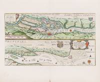
1628200059AG1628. Amsterdam Blaeu 1628. Original hand-coloured engraving. Plate Size: 53 cm x 30.6 cm. Sheet Size: 60 cm x 48.7 cm. Original map. In very good condition. Clean and bright with generous margins. Very minor tear to centre-fold at lower edge. French text on reverse. From Theatrum Orbis Terrarum. The map which is in two strips one above the other shows the course of river Elbe in Germany. Text in Latin and German. The upper map orientated with South facing the upper border focuses on the area around Hamburg with the islands that are surrounding it within the Elbe. The regions' names are given in Latin: Ducatus Luneburgensis and Stormariae Pars for example. The nearby towns such as Buxtehude and Fliegenberg are also included. The islands along the Elbe's estuary are identified: for example Das Grass broeck Kirckhoff and Ross. The maritime and commercial importance of the prosperous city-port is suggested by the many ships seen along the river. Title cartouche coat of arms and decorative bar scale also included in upper map. The lower map shows the continued course of the river 'De Elff Stroom' out to the North Sea passing along Keydingerland De Bilkow and the riverbank towns such as Glückstadt Altrendorp and Brunsbuttel. The islands are identified as 'Dat Krudtstandt oder Pagensandt' and 'Dat Nie Werk'. Decorative cartouche with explanatory and provenantial text coat-of-arms compass rose and ships to sea are also shown on the lower map. Willem Janszoon Blaeu 1571-1638 was a Dutch cartographer atlas maker and publisher. Along with his son Johannes Blaeu Willem is considered one of the notable figures of the Netherlandish/Dutch school of cartography in its golden age the 16th and 17th centuries. Blaeu set up his mapmaking and publishing business in Amsterdam where he sold instruments and globes published maps and edited the works of intellectuals like Descartes and Hugo Grotius. In 1633 he was appointed map-maker of the Dutch East India Company. In 1635 he released his atlas Theatrum Orbis Terrarum sive Atlas novus. Willem died in 1638. He had two sons Cornelis 1610-1648 and Johannes 1596-1673. Joan trained as a lawyer but joined his father's business rather than practice. After his father's death the brothers took over their father's shop and Joan took on his work as hydrographer to the Dutch East India Company. Later in life Joan would modify and greatly expand his father's Atlas novus eventually releasing his masterpiece the Atlas maior between 1662 and 1672. Wikipedia unknown
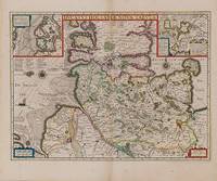
1638200050AG1638. Amsterdam Blaeu 1638. Original hand-coloured engraving. Plate Size: 51.4 cm x 38 cm. Sheet Size: 56.5 cm x 47 cm. Original and rare map. In very good clean condition. Minor tear to lower edge at center-fold. French text on reverse. Beautiful and detailed map of the Duchy of Holstein the northernmost territory of the Holy Roman Empire from the mid-17th Century. To the north lies the Danish Duchy of Schleswig. In the south are Meklenburg and Lower Saxony. Fehmarn Island lies just off Holstein's Baltic coastline. The strategically and commercially important great port cities of Hamburg Kiel and Lubeck are all shown on the map. Holstein is crisscrossed with waterways: the Elbe river being the most prominent and together with Trave provided pathways for the region's trade. The vessel depicted in the North Sea approaching the sandbars suggests the importance of trade to the region. Relief depicted pictorially. Two inset box provide further detail of the specific locales. The inset box in the upper left shows the marshy coastal area around Dagebüll on the western coast. The depicted wierde/terp artifical artificial dwelling mound that were created in the marshy low-lying reclaimed land to provide safe ground during storm surges high tides and sea or river flooding. The inset box in the top right corner shows the area in and around Stapelholm. Cartouches in the lower corners contain bar-scales and provenance details. Annotative text in the North Sea. Two compass roses lie on either side of Holstein. Willem Janszoon Blaeu 1571-1638 was a Dutch cartographer atlas maker and publisher. Along with his son Johannes Blaeu Willem is considered one of the notable figures of the Netherlandish/Dutch school of cartography in its golden age the 16th and 17th centuries. Blaeu set up his mapmaking and publishing business in Amsterdam where he sold instruments and globes published maps and edited the works of intellectuals like Descartes and Hugo Grotius. In 1633 he was appointed map-maker of the Dutch East India Company. In 1635 he released his atlas Theatrum Orbis Terrarum sive Atlas novus. Willem died in 1638. He had two sons Cornelis 1610-1648 and Johannes 1596-1673. Joan trained as a lawyer but joined his father's business rather than practice. After his father's death the brothers took over their father's shop and Joan took on his work as hydrographer to the Dutch East India Company. Later in life Joan would modify and greatly expand his father's Atlas novus eventually releasing his masterpiece the Atlas maior between 1662 and 1672. Wikipedia unknown
1617D3698Berlin 16 April 1738. Hardcover. Very Good. Manuscript on vellum in German. 14 leaves 1 blank folio 350 x 243 mm. 17 lines written in a dark brown ink in an ornate gothic bookhand opening leaf with an elaborate penwork border the upper half with densely drawn scrollwork that interlocks with intermittent flower buds each additional leaf with a repeated penwork border of scrolling acanthus in free-form loops that create geometric patterns many in-text penwork flourishes. Fol. 13r signed "Carl" of Charles VI and signed by the scribe notary E. F. F. von Glandorff. In contemporary crimson velvet two holes in the hinges of the leaves where the cord and seal of Charles VI would have appeared slightly thumbsoiled some darkening to vellum; spine rubbed and velvet binding faded at edges. <br/><br/>A fine example of German 18th-century penmanship by Von Glandorff. The three brothers von Bruhl were sons of Heinrich von Bruhl who had been ennobled the previous year and who became Minister of Saxony under King August. hardcover
1650130R86Rome . 1650 248 leaves. Manuscript in Italian on the History of Germany and virtually all of Europe in the momentous era of the 1620's prepared for Pope Urban VIII Maffeo Barberini by the Papal Nuncio to the Holy Roman Emperor. Written in a graceful Italian hand. Folio. 340 mm. Text generally clean but with scattered mold stains. Remains of old vellum binding. Interesting colorful paste paper end sheets. With the bookplate of Elkin Mathews = Charles Elkin Mathews 1851-1921 London publisher bookseller and collector who played an important role in the literary life the English speaking world in the late 19th and early 20th centuries. Also with a circular Sneyd family book plate probably Ralph Sneyd 1793-1870 but perhaps earlier. This work is often attributed to Carlo Carafa an incompetent and criminal administrator who was executed for treason at Castel San Angelo on Mar 4 1561 by Pius IV. but it is certainly by a later Carlo Carafa born in Naples in 1611 who was bishop of Aversa and Papal Nuncio to Switzerland the Republic of Venice and to the Holy Roman Emperor. The Holy Roman Emperor at this time was Ferdinand II 1578-1637 a member of the House of Habsburg. He was also King of Bohemia and King of Hungary. His rule coincided with the Thirty Years' War. Ferdinand's aim as a zealous Catholic was to restore Catholicism as the only religion in the Empire and suppress Protestantism. The Neapolitan Carafa family produced a large number of bishops cardinals and some saints. Cardinals in the Carafa family include with dates of their elevation to Cardinal: Filippo Carafa 1378; Oliviero Carafa 1467; Gianvincenzo Carafa 1527; Carlo Carafa 1555; Diomede Carafa 1555; Alfonso Carafa 1557; Antonio Carafa 1568; Decio Carafa 1611; Pier Luigi Carafa seniore 1645; Carlo Carafa della Spina 1664; Fortunato Ilario Carafa della Spina 1686; Carafa di Belvedere 1764-1830; Francesco Carafa della Spina 1773; and Domenico Carafa della Spina 1844. Biographical and bibliographic confusion among them is rampant. UNIQUE. A wonderful item for further scholarly study. Chest 2/4. (Rome? ?). hardcover