4 résultats
185628032Philadelphia: Charles Desilver 1856. 17¼" X 13 3/4" image 15" X 12½". Hand colored. Decorative border. Very good. 2" tear at upper right corner archivally repaired on verso touches upon one corner of border. Charles Desilver unknown
188234833La Paz: Imprenta de la Libertad 1882. First edition. Cloth. Title page with chip to top inner edge and neat label with name inked out shallow rough area on fore edge of last few leaves otherwise a very good copy. i 97 1 iii pp. 4to. Bolivian tariffs. Scarce. OCLC shows no copies for this year but Univ. Texas holds similar volumes for 1879 and 1890 and Univ. Illinois has 1894. Parreño sale 70. Imprenta de la Libertad hardcover
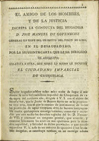
181137071Buenos Aires: Imprenta de Niños Expósitos 1811. First edition. Paper-covered boards. Small chips to spine ends lacking half of the free front endpaper catalogue listing tipped-in to verso; contents trimmed scattered wormholes affecting a few letters of text else clean. 12 pp. Sm. 8vo. 29 March 1811. Furlong cites two editions. This is the "virey de Lima" issue. Attacks General José Manuel de Goyeneche y Barreda 1st Count of Guaqui Grandee of Spain Arequipa Viceroyalty of Peru 1776-1846 who was the commander of the Spanish troops in Bolivia and who had defeated the Revolutionary forces at La Paz in 1809. Two months after this document was issued he signed an armistice with the political leader of the independentist army Juan José Castelli though it was soon broken and Goyeneche went on to occupy all of upper Peru. Furlong IV: 2470. Zinny: Bibliografía histórica p.59: No. 8. Fors: Imprenta de los Niños p. 38. Imprenta de Niños Expósitos hardcover
18512007AG1851. London & New York J & F. Tallis 1851. Original steel engraving / Vintage map. Drawn and engraved by John Rapkin. Partly hand-coloured. Plate Size: 24.7 cm x 33.8 cm. Sheet Size: 27.4 cm x 37.5 cm. Vintage 19th century map in very good condition. John Tallis 7 November 1817 3 June 1876 was an English cartographic publisher. His company John Tallis and Company published views maps and atlases in London from roughly 1838 to 1851. Tallis set up as a publisher with Frederick Tallis in Cripplegate in 1842; the business moved to Smithfield in 1846 and was dissolved in 1849. From 1851 to 1854 Tallis operated as John Tallis and Company. He started The illustrated news of the world and national portrait gallery of eminent personages in 1858 selling it for £1370 in 1861; it folded in 1863. Wikipedia The most important project John Tallis undertook was the 'Illustrated Atlas' from 1851. The original map we offer here was part of this exceptional Atlas and all the maps it contained are still today considered as the last reminder of an era of lavish map production. Tallis worked the project together with John Rapkin 1815-1876 and it was Rapkin's style and talent that we have to thank for when we marvel at these maps today. What makes these maps so special is the detail of engraved vignettes that surround the map and often show indigenous scenes people in their environment and even more so historical buildings or historical views of towns and cities architecture and landscape. The project of 'The Illustrated Atlas' was designed to be finished just in time for the anxiously awaited "Great Exhibition of the Works of Industry of All Nations" or The Great Exhibition sometimes referred to as the Crystal Palace Exhibition in reference to the temporary structure in which it was held was an international exhibition that took place in Hyde Park London from 1 May to 11 October 1851. It was the first in a series of World's Fairs exhibitions of culture and industry that became popular in the 19th century and it was a much anticipated event. The Great Exhibition was organized by Henry Cole and Prince Albert husband of the reigning monarch Queen Victoria. It was attended by numerous notable figures of the time including Charles Darwin Samuel Colt members of the Orléanist Royal Family and the writers Charlotte Brontë Charles Dickens Lewis Carroll George Eliot and Alfred Tennyson. Music for the opening was under the direction of Sir George Thomas Smart and the continuous music from the exhibited organs for the Queen's procession was "under the superintendence of William Sterndale Bennett". Wikipedia unknown