Canada; ManitobaABAA

48 résultats
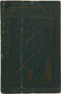
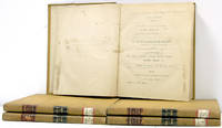
1871512371871. Winnipeg: Coldwell and Cunningham 1871 1873-1887. Winnipeg: Coldwell and Cunningham 1871 1873-1887. Manitoba Statutes 1871-1887 Canada. Manitoba. Statutes of Manitoba 1871-1887. Winnipeg: Printed by Coldwell and Cunningham Printers to the Queen's Most Excellent Majesty 1871 1873-1887. 12 books in all. Octavo 8-1/2" x 5-1/2". Later quarter cloth or calf moderate to heavy shelfwear backstrips lacking from two volumes several boards loose internally clean. Ex-library. Location labels to spine small stamps to title pages. $500. One of the ten provinces of Canada Manitoba was established in 1870. It was the first province created from the Northwest Territories. These volumes document the early legal and social history of the province an interesting period that marked its final transition from a collection of territorial settlements to a mature political entity. No sets of these early statutes on OCLC. Sweet & Maxwell A Legal Bibliography of the British Commonwealth 3:75. unknown books
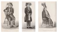
186114866London: A.W. Bennett 1861. First Edition. Hardcover. Very good. 12mo. pp. viii 278 2 ads frontis portrait of the author and 15 plates illustrating aspects of Ojibwe life and culture. Rebound in green cloth gilt title on spine. Edges trimmed mild spine slant; very good. Jones 1802-1856 was a Mississauga Ojibwe chief and Methodist minister from Upper Canada. As a missionary he made significant inroads for Methodism by translating hymns and biblical texts into Ojibwe and Mohawk and because of his ability to communicate with non-English speaking Indians. This work edited and published posthumously by Jones' wife Eliza offers a detailed survey of the history social structure religious beliefs ceremonies language etc. of the Ojibwe in Canada and the United States. A final chapter offers an assessment of the "present state and future prospects of the North American Indians." Sabin 36590; Howes J-238; Field 797. A.W. Bennett hardcover books
1855WRCAM24391Montreal 1855. 106pp. plus two large folding maps. Original cloth stamped in gilt "ESSAI COURONNÉ SUR LE CANADA" on the front cover. Spine ends frayed. Inner hinges cracked spine shaken but holding. Some scattered foxing. Good. A very detailed description of every aspect of Canada accompanied by a "Map of the Province of Canada and the Lower Colonies showing the connection by steam navigation with New York Pennsylvania Ohio Indiana Illinois Michigan Wisconsin & Minnesota." and a map of "Mercators Projection. With the Great Circle Shortest Sailing or Air Lines. Illustrating the directness & capacity of the River St. Lawrence from Lake Erie to the Atlantic." According to a note in TPL the maps were apparently not issued with all copies. This work was published with another essay in Montreal the same year in an English language edition. TPL 3557. GAGNON I:1696. SABIN 32422. hardcover books
182647476Montreal: Imprime´ chex James Lane 1826. 46 pp. with the errata slip. 1 vols. 8vo. Stitched in modern plain wrappers. A fine copy of a scarce and important Canadian pamphlet. 46 pp. with the errata slip. 1 vols. 8vo. Excerpts from a journal and letters written during a trip to the United States in 1819. This serves as a sequel to Viger's "Considerations sur les effets qu'ont produit en Canada la conservations des etablissemens du pays les mœurs l'education etc. de ses habitans." 1809. Sabin 10350; Gagnon I: 111; TPL 1190 Imprime´ chex James Lane unknown books
1881WRCAM30264AMontreal: John Lovell & Son 1881. 219pp. plus large folding color map. Original printed wrappers. Minor wear to wrappers three-inch closed tear in map. Contemporary stamp of the U.S. Geological Survey Library on titlepage. Internally clean. Very good. Issued by the Nelsen Valley Railway Transportation Company this pamphlet and map advertise a new route to the middle of North America. The route marked by a heavy red line takes potential passengers through Hudson's Strait to Churchill Harbor Canada then south by train to the United States border in northern Minnesota. PEEL 448. John Lovell & Son unknown books
1872WRCAM39322Montreal: Dawson Brothers 1872. Colored folding map 33 x 22 1/2 inches. Folded into original pebbled cloth. Front board detached. Bisected and mounted on linen as issued. Old bookplate and withdrawal stamp on front pastedown short closed tear along linen fold of upper outer section not affecting map itself. A handsome detailed folding map showing southeast Canadian territory including Cape Breton the Province of Quebec and provides detailed illustration of the northeast United States spanning from eastern Michigan all the way to New York Harbor. With two small insets of Newfoundland and the environs of Montreal and one larger inset extending to British Columbia and Manitoba. Also illustrates railway routings completed and those under construction and denotes "Free Grant Lands" with color illustration. An interesting late 19th-century map of Canada published only one year after western British Columbia joined the Canadian Confederation to help form the Canadian Pacific Railway. Dawson Brothers hardcover books
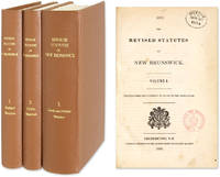
1854511091854. Fredericton: 3 Vols. Complete set. 1845-1855. Fredericton: 3 Vols. Complete set. 1845-1855. First Compilation of New Brunswick Statutes Canada. New Brunswick. The Revised Statutes of New Brunswick. Printed Under the Authority of an Act of the Legislature. Fredericton: J. Simpson Printer to the Queen's Most Excellent Majesty 1854-1855. Three volumes. Complete set. Octavo 9" x 6". Recent cloth gilt titles to spines endpapers renewed. Clean tears to first page of Volume I Preface annotations in early hand to margins of Volume I in some places interiors otherwise clean. Ex-library. Small stamps to title pages. $450. Only edition. Volume II: The Public Statutes of New Brunswick Passed in the Year 1854 Together with Those Unrepealed by the Revised Statutes; Volume III: The Local and Private Statutes of New Brunswick. Settled by the French New Brunswick was taken by the British in 1759 and incorporated into the colony of Nova Scotia. Its population expanded significantly through an influx of Loyalists after the American Revolution. Its enlarged population and distance from Halifax the capital of Nova Scotia led the colonial administrators to establish New Brunswick as a separate colony in 1784. The first collection of New Brunswick acts covering the years 1786-1805 was published in 1805. The Revised Statutes was the first compilation. In 1867 New Brunswick was one of the six colonies that became the Canadian Confederation. Sweet & Maxwell A Legal Bibliography of the British Commonwealth 3:77. unknown books
1848WRCAM47361London 1848. 171pp. Folio. Modern half morocco and red cloth spine gilt. Cloth bubbling. A bit of light soiling. Near fine. The late 1840s saw a major push for the colonization of Vancouver Island. This series of thirteen letters includes a document issued by the British Crown establishing the right of the Hudson's Bay Company to colonize the island. The report describes Vancouver Island and the prospects for colonization. One of the reports is by James Douglas a fur trader and Hudson's Bay Company official who in 1851 succeeded Richard Blanshard as governor of Vancouver Island. Considered the "father of British Columbia" Douglas became the first governor of the colony of British Columbia in 1858. The Hudson's Bay company controlled the development of Vancouver Island until 1866 when it was annexed to British Columbia. STREETER SALE 3399. GAGNON 3460 TPL 2908. LOWTHER 7. hardcover books
1849WRCAM22323Montreal: Armour & Ramsay 1849. 21533pp. plus large folding map 36 x 19 1/4 inches. 12mo. Original green cloth stamped in blind and gilt. Map detached from book with tape reinforcements on verso along several folds. Else clean and very good. A rare anonymous Canadian guide book containing Edward Staveley's fine engraved map of Canada: "A Map of Canada Compiled from the latest Authorities. By Edward Staveley. Montreal 1848. Engraved by W. & A.K. Johnson Edinburgh for Armour & Ramsay Montreal." With inset maps of Montreal Quebec Niagara Kingston and Toronto. This map is well-known and first appeared separately in 1844. The text consists of interesting descriptions of tourist destinations historical essays a tariff schedule for all manner of produce and accounts of the primary Canadian cites and towns. This is the fourth issue of the map and the first edition of THE CANADIAN GUIDE BOOK. TPL 2975. GAGNON I:661. PHILLIPS MAPS p.197. DIONNE 565. SABIN 10627. Armour & Ramsay hardcover books
188135023Ottawa: Printed by MacLean Roger & Co. 1881. Original printed salmon wrappers stitched. 2 10 large folding map short closed tear 20 11 3 2 2 pp as issued. Vertical fold light edgewear. Very Good.<br/> offered with Booth C.J. President: THE CANADA ATLANTIC RAILWAY CO'Y. PROSPECTUS. Ottawa: 1889. 4 pp printed on rectos only. Caption title as issued. Pinned at upper blank corner and docketed in ink on final blank "Canada Atlantic RR Prospectus January 1889." Fine.<br/><br/> The map in excellent condition is titled "Canada Atlantic Railway Map December 1881" accomplished by "Geo. Bishop & Co. Lith. Montreal." It measures 18" x 35" with the route of the railway; extensions and other railways also notes; other boundaries in green. All the documents creating the Company set forth in the title of the pamphlet are printed each individually numbered. The Railway as the Prospectus states "extends from Ottawa in a south easterly direction a distance of 142 miles and connects with the Central Vermont Railroad at the village of Alburgh Springs Vt. U.S.A."<br/> "The Canada Atlantic Railway CAR was a small regional railway created in 1880 by lumber baron John Rodolphus Booth. Initially planned as part of the transportation network for his vast lumber holdings the railway quickly grew into a general-purpose railway serving passengers and communities along the route. Booth's first target was to gain access to Vermont in order to connect with the Central Vermont Railway CV and further exploit the US markets" "Canada Atlantic Railway" Ontario Railways accessed at Canada-Rail website May 2018.<br/> As of May 2018 we do not locate either of these documents-- or the map-- on OCLC. Printed by MacLean, Roger & Co. unknown books
1842248173London: Goerge Vertue 1842. First edition. Engraved vignette title-page to each volume portrait frontispiece to first engraved map and 116 engraved plates after drawings by Bartlett. 128; 166 pp. 2 vols. 4to. Full contemporary black calf gilt spine plain endpapers. A little rubbing at extremities labels chipped both vignette titles and title pages quite severely stained and inner margins of most plates in Vol. One. Bartlett W.H. First edition. Engraved vignette title-page to each volume portrait frontispiece to first engraved map and 116 engraved plates after drawings by Bartlett. 128; 166 pp. 2 vols. 4to. Sabin 3786; Lande 2310; Alston 7673; TPL 2424 Goerge Vertue unknown books
1866240437London: Hurst and Blackett Publishers 13 Great Marlborough Streeet 1866. First edition with tipped-in errata slip. 6 chromolithographs and numerous text illustrations. xv 3 334 pp. 1 vols. 8vo 26.5 x 18 cm. Original green cloth with gilt moose on upper cover. Fine. Signed "With J.B. Keith's best wishes. June/66. First edition with tipped-in errata slip. 6 chromolithographs and numerous text illustrations. xv 3 334 pp. 1 vols. 8vo 26.5 x 18 cm. A detailed and useful guide to Canadian sport. Four of the 12 chapters are devoted to fishing: "The Fisheries of Canada" concerning salmon rivers lakes and lesser waters; "The Salmon" its location size etc. includes data on trout and white fish; "The Canadian Shad" habitat etc. including other fish; and "The Tom Cod" annual arrival etc. including discussion of bass sturgeon and others. Rare. Bruns K-49; Gee p. 61; Lande 1886; Sabin 37857; TPL 6220 Hurst and Blackett, Publishers, 13, Great Marlborough Streeet unknown books
183534163Quebec: Printed by Thos. Carey & Co 1835. 8vo. xxviii 2 2 192 30pp. Contemporary cloth paper label on spine soiled and worn.<br/> <br/>Regulations regarding the British regiment stationed in Canada.<br/> <br/>The introductory leaf is signed in print by Duncan McDougall the Lt. Col. commanding the regiment.<br/> <br/>TPL 1888. Printed by Thos. Carey & Co unknown books
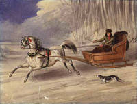
1840WRCAM19322N.p. 1840. Watercolor on stiff paper. 27.2 x 20.8 cm. With a rather unobtrusive 7 cm. tear through the lower left quadrant. Contemporary manuscript title on verso "An American Cutter." Overall a fine image. A handsome unsigned watercolor depicting a single-horse sleigh pulling a clever-looking American trapper with hunting dog barely keeping up. A lively image probably a Canadian scene very displayable. unknown books
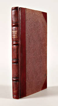
1831WRCAM50737Quebec: Ordered by the Assembly to the printed 1831. Four volumes bound in one. 56; 61; 47; 50pp. 20th-century red three-quarter calf and cloth spine gilt. Bookplates on front pastedown. Some minor foxing and soiling. Very good. Two government reports each printed in English and then French regarding the exploration of Lower Canada. Scarce; not cited in TPL Lande or Gangon. Relatively early for Canadian imprints. Ordered by the Assembly to the printed hardcover books
1881547Ottawa 1881. Very good. Broadside 18.5 x 6 inches. One horizontal fold. Small chip at left edge not affecting printed area. Light tanning. A rare illustrated railroad broadside that advertises an 1881 voyage from Ottawa and several other towns in Ontario via the Canada Central Railroad to Iowa the Dakotas and Minnesota for the purpose of locating and purchasing an American homestead. "Now is the time to Possess Yourselves of the CHEAP LANDS being offered by the Government and Railroad Co's. The extraordinary emigration to the West from the Old Countries promised for the coming summer will be no myth and another year where now you can accommodate yourself to a Splendid Farm fine location for Work Shops &c. will be occupied by the more energetic foreigner. So arrange your business matters and go with us on May 31 1881." The advertised route involves two legs to Chicago on the Canada Central and Michigan Central and thence on connecting lines to Lemars Iowa; and Watertown Yankton and Huron in the Dakota Territory. A fascinating confluence of railroad excursion promotion homestead land advertisement enticement to international emigration and xenophobia. We locate copies at Yale and the Toronto Public Library. unknown books
1830WRCAM33087Quebec 1830. Two volumes bound in one printed alternately in English and French. 7288; 410- 13934-1958pp. Quarto. Antique-style half calf and marbled boards Very good. A reprint of the first collection of Canadian statutes as it appeared in 1795 to which has been added the first printings of the provincial statutes for 1797 to 1800. The first 186 pages of the first volume of statutes appear here as original sheets remaindered from the first edition. According to Tremaine these sheets were occasionally offered as "complementary sections" of the 1830 reissue. In the second volume statute titles appear only for those statutes no longer in force. The series ceased publication in 1831. In all a useful resource for early Canadian laws. TPL 644. GAGNON 2:2046. SABIN 10497. TREMAINE 943 1053. hardcover books
1864WRCAM47423London 1864. 162pp. Folio. String-tied as issued. A bit tanned some small chips at the edges. Very good. The Thomas W. Streeter copy with his pencil notes on the titlepage. This House of Commons working paper is a continuation of their return dated July 10 1863 on the subject of constructing a telegraph line to British Columbia and the Pacific. The Hudson's Bay Company unsurprisingly was intimately involved in the machinations for the building of the line. They had made an agreement with the Canadian government to build the telegraph line from the Red River to the Pacific themselves but when they failed to do so a group of English bankers proposed to step in and do the job. The papers included herein provide much information on the qualities of the land between Lake Superior and British Columbia and the need for swift communication throughout and across the vast region. Also included is a memorial from the people of the Red River Settlement discussing their urgent need for the telegraph. <br> <br> The Streeter copy sold to Nebenzahl for $30 in 1969 and was still in his stock when the Reese Company bought the last of it in 2013; here it is. STREETER SALE 3436 this copy. SOLIDAY I:1207. LOWTHER 228. unknown books
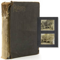
1890319445Newfoundland and Labrador 1890. 91 photographs. Most photos measure 4 x 5 inches. A few captioned in manuscript on verso. Black cloth spine perished. 91 photographs. Most photos measure 4 x 5 inches. A few captioned in manuscript on verso. The images include several aboard ship and arriving at the dock as well as images along the river and campsite including scenic views as well as images of the unidentified travellers. Other Humber River images depict villages salmon fishing with women participating including one holding a rifle. A number of photos depict indigenous peoples possibly Inuit Innu Mi'kng or So. Innit of Nu nath Kavut. The travellers must have taken another passage north with images of Labrador cliffs and even an iceberg. unknown books
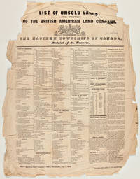
1842WRCAM39134Montreal: Printed by John C. Becket 1842. Broadside 22 1/2 x 17 3/4 inches. Printed in six columns. Small tears and creasing at all margins affecting a few words of text; significant loss at upper corners not affecting text. Good. A Canadian broadside advertising lands available in the Eastern Townships printed at the beginning of the region's transformation into a French-speaking area. In the early 1800s the Eastern Townships were an almost exclusively Anglophone region of Quebec. The American Revolution precipitated the flight of over 40000 Loyalists to Canada in the 1780s including a small handful to the largely unsettled region of Quebec between the St. Lawrence River and the U.S. border known as the Eastern Townships. The Loyalists cleared much of the rich land for farming which attracted a large number of immigrants from New England in the first decades of the 19th century. In the 1840s a rapid shift occurred in the region as French- speaking Quebecois from poorer areas began pouring in and the English speakers began emigrating to the U.S. and other parts of Canada. Francophones became a majority in the 1870s and today constitute over 85% of the population. <br> <br> The present broadside printed in English lists hundreds of lots for sale by the British American Land Company and includes over a column's worth of detailed descriptions of lands open for purchase. The following towns and areas are represented: Ascot Auckland Brompton Compton Clifton Clinton Ditton Dudswell Eaton Hereford Melbourne Newport Orford Shipton Stoke Weedon Westbury and Windsor in the County of Sherbrooke; Barford Barnston Bolton Hatley Potton and Stanstead in the County of Stanstead; Brome Ely Farnham Granby Milton Roxton Shefford and Stukeley in the County of Shefford; Acton Aston Chester Durhan Grantham Ham Kingsley Simpson Tingwock Warwick Wendover and Wickham in the County of Drummond; Sutton in the County of Missisquoi; Hemmingford in the County of Beauharnois; and improved farms in the district of St. Francis Territory Port St. Francis and the town of Sherbrooke. Not listed on OCLC and apparently unrecorded. Very rare. Printed by John C. Becket unknown books
1840WRCAM32893Montreal 1840. Five volumes of six. 10030; 621; 10510; 16178; 20222130pp. Quarto. Later cloth red and black gilt morocco labels. Moderate soiling on covers library labels at toe of spines. Uniform light toning. Perforated library stamps on titlepages occasional additional library markings. First twenty pages of last volume in typescript facsimile. Overall very good. Lacks the sixth volume. An important collection of Canadian laws as passed by the Special Council of Lower Canada from 1838 to 1840. When the Patriot Uprising of 1838 caused Canadian officials to suspend the 1791 constitution which had divided Canada into the Upper and Lower Provinces each with their own legislature and establish martial law the provincial judiciary assumed administrative control in the form of the Special Council. The Special Council continued in an administrative capacity until the Union Act of 1840 which reunited the provinces with a single legislature. A fundamental cause of the Patriot Uprising was the ambiguous extent of judiciary power; based on the reign of the Special Council recorded in detail here judicial powers were more clearly defined via the Union Act. TPL calls for six volumes bound in three. The present set features each volume bound separately lacking the sixth volume. The large portions of unnumbered pages at the end of each contain sessional papers appendices and indices. <br> <br> Key insight into a tumultuous period of Canadian legal history. The journals were also issued in French. OCLC locates only five copies none of which appear to be complete. TPL 2173. GAGNON I:1830. OCLC 12010933 63013527. hardcover books
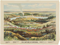
1885WRCAM54034Toronto: Toronto Lithographing Co. 1885. Three color lithographs. Cut Knife and Fish Creek: approximately 20 1/4 x 26 3/4 inches; Capture at Batoche: approximately 19 1/2 x 26 1/4 inches. Cut Knife and Fish Creek trimmed about 3/4 inch along the top margin and about 1 1/4 inches along left margin. Capture at Batoche trimmed slightly more but evenly in each margin and adhered to backing board. Overall good plus. A trio of rare battlefield views depicting three of the major skirmishes fought during the North-West Rebellion in Saskatchewan in 1885. This series of battles is also known by several other names including the Saskatchewan Rebellion the Northwest Uprising and the Second Riel Rebellion the first Riel Rebellion occurred near Manitoba in 1869 and is also known as the Red River Rebellion. Both the 1869 and 1885 actions were led by Louis Riel the leader of the Métis people. <br> <br> Chronologically the lithographs are as follows: <br> <br> 1 "Battle of Fish Creek." This battle occurred on April 24 1885 and resulted in a stunning victory when around 200 Métis soldiers overcame a superior force of 900 government soldiers and temporarily halted an advance on Batoche. <br> <br> 2 "Battle of Cut Knife." On May 2 1885 a force of Cree warriors held off a superior group of Canadian army units. <br> <br> 3 "The Capture of Batoche." Effectively the end of the rebellion the Métis were soundly defeated in the second week of May after they ran out of ammunition on the third day of fighting. This action forced Riel to surrender on May 15. <br> <br> The Métis are one of the recognized aboriginal groups in Canada who trace their roots to the first interaction between First Nations people and the earliest European settlers usually French and largely as a result of the fur trade. The Métis are among the earliest mixed-race people in Canada and developed a separate distinct culture based on their ancestral origins usually stemming from the coupling of an indigenous woman and a male European settler. <br> <br> By the 19th century the Métis were well- assimilated into French-Canadian culture and many worked as fur traders for the North-West Company or Hudson's Bay Company or supplied furs as independent trappers. When those companies pulled out of the Red River and Saskatchewan regions in the mid-to-late 1800s the Canadian government took over the land and began to enforce their will on the Métis people. <br> <br> The first armed conflict between the Métis and the Canadian provincial government occurred in 1869 in the Red River region where Louis Riel led an unsuccessful rebellion. Some fifteen years later the Métis formed their own provincial government in western Saskatchewan after hearing that the Canadian government was sending mounted police to enforce Canadian law in the region. This Second Riel Rebellion occurred in a series of skirmishes between the Métis and the Canadian armed forces between March 26 and May 12 1885. Though led by Louis Riel the Métis ultimately lost again to the Canadian government. Still both rebellions helped the Métis gain some measure of recognition and respect from the Canadian government that they would very likely not have earned otherwise. <br> <br> The lithographs were produced by the Toronto Lithographing Company purveyors of patriotic views of famous Canadian wars. In this case the company assigned W.D. Blatchly to paint the scenes for the 1885 conflicts; Blatchly was at the time one of the leading artists in all of Canada. <br> <br> An excellent series of lithographs illustrating three important events in the famous rebellion with outstanding display appeal. Toronto Lithographing Co. unknown books
1817WRCAM32892Quebec 1817. Twenty-four volumes. Later brown cloth red and black gilt morocco labels. Printed in alternating English and French. Slight wear to and moderate soiling on covers. Occasional foxing. First view leaves of first volume torn along lower blank margin. Occasional old institutional markings. Overall very good. A large and impressive archive of Canadian laws. In an effort to pacify the disparate French and British populations of Canada the Constitutional Act of 1791 divided Canada in two. Upper Canada was primarily populated by Loyalist emigrants of the American Revolution while the citizenry of Lower Canada which included Quebec was mostly of French descent. These are the laws of Lower Canada printed in English and French. Though the first volume appeared in 1793 it includes material from the first session of the first Parliament held in December 1792. The series continued till 1836. "Public accounts are included in the early numbers of the Journals and from 1809 to 1835-36 Sessional papers are published as appendices to the Journals" - TPL. Present here is a complete run from its inception to 1813 with an additional volume for 1817. The twenty- third twenty-fourth and twenty fifth volumes are lacking. Scarce. OCLC locates only six complete runs. <br> <br> A prime resource for the study of Canadian legal history. TPL 640. SABIN 10491. OCLC 11820245 48957532. TRÉMAINE 835. hardcover books