73 résultats
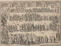
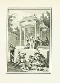
1788ST20889Paris: Chez l'Auteur 1788 1788. FIRST EDITION. 565 x 400 mm. 22 1/4 x 15 3/4". 50 leaves. Two separately published works bound in one. <br/> Modern retrospective calf-backed tan paste paper boards smooth spine profusely gilt with a repeating pattern of grape vines red morocco label lettered in gilt vellum tips. ENGRAVED THROUGHOUT WITH A TOTAL OF 48 FULL-PAGE ILLUSTRATED PLATES each accompanied by either one or two plates of engraved text. SHEETS UNCUT AND UNFOLDED the first work printed only on the recto; the second with three sheets printed on both sides. Reed and Dematté China on Paper 20 21; Cohen-de Ricci 479. Edges and lower corners slightly worn but the binding with only just minor signs of use; free endpaper in front and back with vertical crease one sheet with an early marginal repair isolated inconsequential faint spotting but still AN EXTREMELY FINE COPY the wide-margined sheets exceptionally fresh and bright and with strong impressions of the engravings.<br/> <br/> This pair of lavishly illustrated fully engraved works produced by a talented French engraver after earlier Chinese artworks are here presented in an enormous volume made up of uncut and unfolded sheets. According to Benzit Parisian engraver and print seller Isidore Stanislas Henri Helman 1743 - ca. 1809 "stands out among the engravers of the end of the 18th century" and his skill is evident in the two works bound together here. The first is a pictorial history of the Chinese emperors from the earliest mythical rulers to the Northern Song dynasty 960-1126. It is based on the Dijian Tushuo composed in 1573 to educate the Ming-dynasty Wanli Emperor 1563-1620 who had ascended to the throne at the age of nine. In accordance with its didactic aims it presents the very best and worst of imperial behavior and the original handwritten album was published as a block-printed book to great popularity. Two centuries later the Qing-dynasty Qianlong Emperor 1711-99 commissioned a Western-style edition of the famous work which was executed by two French artists the Jesuit painter Jean-Denis Attiret and the engraver Charles-Nicolas Cochin II. The enterprising Helman was able to see the Attiret-Cochin book in the collection of French statesman Henri Léonard Jean Baptiste Bertin 1720-92 and having had great success with a previous reproduction of a Chinese work Conquêtes de l'Empereur de la Chine ca. 1783 he created the present reproduction. The second work the life of Confucius was also reproduced from plates in Bertin's collection. The source material in this case was the biography of Confucius assembled by the Jesuit Joseph-Marie Amiot 1718-93 as part of his informational series on China meant to educate missionaries. Amiot was a correspondent of Bertin and had sent him the biography and accompanying album of drawings which were based on the Shenji tu Illustrated Traces of the Sage a popular Confucian work throughout the Ming and Qing dynasties. Helman selected 24 scenes from each creating books that balance serene scenes of mountainous landscapes and temples with dramatic fight scenes and dragons. The quality of the engravings is excellent with delicate linework creating faint wisps of smoke and subtle shadows. These two works apparently both published in 1788 were released in several formats. The format here with the engravings laid out on the recto of large uncut sheets appears at auction very infrequently: we have been able to trace only two copies of both works in this format since 2004 and neither in such fine condition as the present example. Chez l'Auteur unknown
1788314738Paris: chez l'auteur . et chez Ponce 1788. First editions. Vol 1: Title 24 plates and 24 leaves of text; vol 2: title dedication 24 plates and 24 leaves of text. 4to. Contemporary green morocco with gilt Greek key borders pink silk endpapers a.e.g. Corners rubbed spine a touch browned marginal foxing in first volume and to a few leaves in second. First editions. Vol 1: Title 24 plates and 24 leaves of text; vol 2: title dedication 24 plates and 24 leaves of text. 4to. First editions beautifully and fully engraved. The first volume is on the life of Confucius the second details notable events in the reigns of various Chinese emperors. The plates were made after a series of drawings by the Jesuit missionary Joseph Marie Amiot. Cohen-De Ricci 479; Lust 729 1133. Provenance: Francis John Hughes bookplate chez l'auteur ... et chez Ponce unknown
1799254690Paris: Chez F. Buisson Imprimeur-Librair rue Hautefeuille no. 20 1799. Seconde édition augmentée d'un Précis de l'Histoire de la Chine par le traducteur et du Voyage en Chine et en tartare de J. C. Huttner traduit de l'allemand par le même Traducteur. Vol.1 : with half-title portrait frontispiece of Macartney clxxxiv 311 pp. Plates 1-6. VOLUME II : half-title 408 pp. Plates 7-13. VOLUME 3 : Half title 414 2 Catalogue "Voyages" de la librairie chez Buisson pp. Plates 14-27. VOLUME 4 : half-title 380 pp. Plates 28-35. VOLUME. 5 : half-title. 350 pp 1 plate 36 and 2 folding maps Plates 37 & 38. 5 vols. 8vo. Nineteenth century brown boards red paper labels some rubbing else Very Good. Seconde édition augmentée d'un Précis de l'Histoire de la Chine par le traducteur et du Voyage en Chine et en tartare de J. C. Huttner traduit de l'allemand par le même Traducteur. Vol.1 : with half-title portrait frontispiece of Macartney clxxxiv 311 pp. Plates 1-6. VOLUME II : half-title 408 pp. Plates 7-13. VOLUME 3 : Half title 414 2 Catalogue "Voyages" de la librairie chez Buisson pp. Plates 14-27. VOLUME 4 : half-title 380 pp. Plates 28-35. VOLUME. 5 : half-title. 350 pp 1 plate 36 and 2 folding maps Plates 37 & 38. 5 vols. 8vo. Cordier Biblioteca Sinica IV 2385 Chez F. Buisson, Imprimeur-Librair, rue Hautefeuille, no. 20 unknown
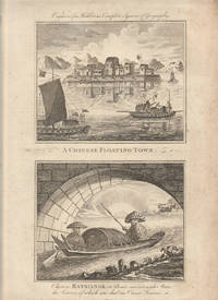
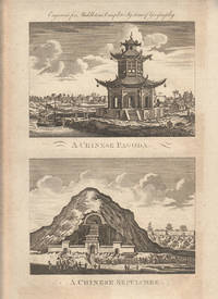
1779178310London. circa1779. A pair of engravings on a single sheet of laid paper each 14 x 15 cm including captions; 37 x 23 cm sheet the sheet with scattered spotting and toning mainly affecting the margins but in very good condition. This engraving appeared in Middleton's "New & Complete System of Geography" 1779 and is an example of the demand for publishers to supply views of the East and exotic "New Worlds". The late-seventeenth and eighteenth centuries had seen a dramatic increase in the publication of voyage accounts and compilations and collections on the London book market. <br> <br>From the Estate of the late collector and scholar Arthur Hacker. . unknown
1779178311London. circa1779. A pair of engravings on a single sheet of laid paper each 13 x 16.4 cm including captions; 37 x 23 cm sheet the sheet with scattered spotting and toning mainly affecting the margins in original uncoloured state as issued in very good condition. This engraving appeared in Middleton's "New & Complete System of Geography" 1779 and is an example of the demand for publishers to supply views of the East and exotic "New Worlds". The late-seventeenth and eighteenth centuries had seen a dramatic increase in the publication of voyage accounts and compilations and collections on the London book market. <br> <br>From the Estate of the late collector and scholar Arthur Hacker. . unknown
1779178306London. circa1779. Engraving on laid paper 29 x 17 cm platemark including caption; 37 x 22.7 cm sheet decorative border and title cartouche lower corner a little creased margins with scattered spotting and toning but in very good condition. This engraving appeared in Middleton's "New & Complete System of Geography" 1779 and is an example of the demand for publishers to supply views of the East and exotic "New Worlds". The late-seventeenth and eighteenth centuries had seen a dramatic increase in the publication of voyage accounts and compilations and collections on the London book market. <br> <br>From the Estate of the late collector and scholar Arthur Hacker. . unknown
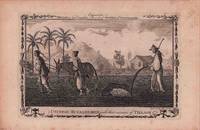
1782178309London. circa1782. Engraving on laid paper 19 x 28.8 cm platemark including caption; 24.5 x 37 cm sheet decorative border edge tears and toning and occasional spotting but in very good condition. This engraving appeared in Millar's "New complete & Universal System of Geography" and is an example of the demand for publishers to supply views of the East and exotic "New Worlds". The late-seventeenth and eighteenth centuries saw a dramatic increase in the publication of voyage accounts and compilations and collections on the London book market. <br> <br>From the Estate of the late collector and scholar Arthur Hacker. . unknown
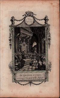
1744178291London. circa1744. Engraving on laid paper 21.5 x 28.4 cm trimmed to the image in very good condition. Wonderfully detailed engraving showing with great flourish the retinue of the Chinese Emperor published in "An Account of the Empire of China" by Dominick Fernandez Navarette extracted from the great 18th Century voyage compliation by Awnsham and Churchill. <br> <br>From the Estate of the late collector and scholar Arthur Hacker. . unknown
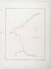
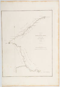
1796209283London.: George Nicol. 1796. Engraved copperplate map on Whatman paper 43.8 x 33.6 cm; 57 x 42 cm sheet including plate markscale in nautical and English miles; light undulation to sheet marginal toning and edgewear but in very good condition. Finely engraved and detailed map of two routes to Pekin Beijing along the White River Baihe from the Gulf of Petcheli and along the Imperial Highway from Jehol and includes commentary locating palaces and gardens type of cultivation "many barges" and "the road shaded by willow trees". The map elegantly drawn by Henry William Parish was published in George Staunton's account of Earl Macartney's embassy to China 1792-1794. . George Nicol. unknown
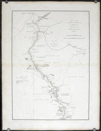
1796207049London.: George Nicol. 1796. Double-sheet engraved copperplate map 63.2 x 44.8 cm; 75 x 57 cms sheet including platemark central fold the sheet toned at the edges and central fold a couple of minor spots and edge wear but in very good condition. An exquisitely engraved map with fine detail of the route taken by George Macartney on the first official British embassy to China 1792-1794 undertaken with the aim of gaining trade concessions from the Chinese Emperor and published in George Staunton's officall account. <br> <br>While the official purpose was not successful much was learned about China and the Chinese as is evident from this map with its explanatory texts. To the west of Pekin just below the starting point at Zhe-hol Jehol which is situated at the top of this map the commentary reads: "A great part of the country around Pekin is employed in the production of culinary vegetables and a variety of fruits." At the lower edge of the map just north of the ending point of Hangzhou is the lake Tai Hoo: "The western side of the Tai-hoo is bounded by a very romantic and fertile country whose mountains are clutivated to their very tops. A great part of the province of Tche-tchiang appears to be cultivated with Mulberry trees for the food of the Silk worms." Cities of the 1st 2nd and 3rd orders "considerable towns" and villages are marked along with "Halting places" etc. Fascinating Western documentation of the area around the Imperial Canal of the late Eighteenth Century. . George Nicol. unknown
1796197217London.: George Nicol. 1796. Engraved copperplate map on Whatman paper 43.8 x 33.6 cm; 57 x 38.5 cm sheet scale in nautical and English miles; light undulation to sheet marginal toning and edgewear a couple of rust spots to the blank of the map's lower corner trimmed to the border on the inner margin but in very good condition. Finely engraved and detailed map of two routes to Pekin Beijing along the White River Baihe River from the Gulph of Petcheli and along the Imperial Highway from Jehol and includes commentary locating palaces and gardens type of cultivation "many barges" and "the road shaded by willow trees". The map elegantly drawn by Henry William Parish was published in George Staunton's account of Earl Macartney's embassy to China 1792-1794. . George Nicol. unknown
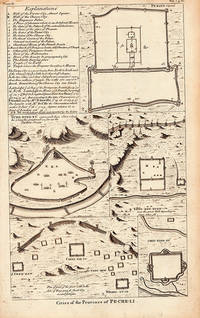
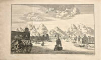
1738206300London. 1738. Five engraved architectural plans and a key together 36 x 21.6 cms; 40.2 x 25.3 cms sheet age-toning small tide-mark affecting an upper corner but overall in very good condition. Attractive group of engravings depicting walled cities of the Chinese Qing dynasty province of Pe-Che-Li today Zhili province. The engravings show a plan of Peking with a key at left; Yung-ping-fu Guangfu; Long-men-hyen Luoyang; Chin-ting-fu; and a "Plan of part of the great wall on the Side of Yung-ping-fu flank'd by several fortresses." This is a plate from an English edition of Jean Baptiste Du Halde's encyclopedic compendium of the written accounts of some 27 Jesuits in China documenting the history and customs of the country. . unknown
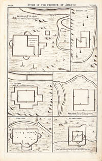
1738206290London. 1738. Six engraved architectural plans together 36 x 21.6 cms; 40.2 x 25.3 cms sheet age-toning short edge tear at lower corner soft creasing at upper left corner very good condition. An attractive suite of engravings depicting six walled cities of the Chinese Qing dynasty province of Shen-si now Shaanxi in northwestern China : Si-ngan-fu Xi'an Chwang-lan Zhuanglang Lan-chew Lanzhou Kan-chew Ing-chew and Ku-ywen Chew. This is a plate from an English edition of Jean Baptiste Du Halde's encyclopedic compendium of the written accounts of some 27 Jesuits in China documenting the history and customs of the country. . unknown
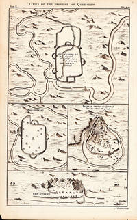
1738206287London. 1738. Five engraved architectural plans together 36 x 21.6 cms; 40.2 x 25.3 cms sheet age-toning small repaired edge tear overall very good condition. Suite of 18th Century engravings from an English edition of Jean Baptiste Du Halde's encyclopedic compendium of the written accounts of some 27 Jesuits in China documenting the history and customs of the country. <br>The engravings show the four walled cities of the Chinese Qing dynasty province of Quey-Chew present Guizhou in Southwest China: Quey-Yang Fu Guiyang Ping-Ywen Fu Pu-ngan Chew and Chin-Ywen Fu. . unknown
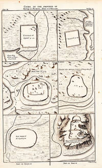
1738206291London. 1738. Six engraved architectural plans together 36 x 21.6 cms; 40.2 x 25.3 cms sheet age-toning inner margin with paper loss to plate mark not affecting the engravings overall very good condition. An attractive suite of engravings depicting six walled cities of Chinese Qing dynasty provinces: Yun-nan Fu Ta-li Fu Dali Kyen-ning Jian'ou Chang-tay Hyen Nan Chang Fu Nanchang and Kya-chew Pingyao. This is a plate from an English edition of Jean Baptiste Du Halde's encyclopedic compendium of the written accounts of some 27 Jesuits in China documenting the history and customs of the country. . unknown
1745199410London. 1745-1747. Copperplate engraving 20 x 33.2 cms image 25 x 43 cms sheet original folds a little age-toned but in very good clean condition. A striking view of Nanxiong in the province of Guangdong central to the tea route leading to Canton Guangzhou <br>The image is after the work of Johan Nieuhof 1618-1672 whose 17th century views were amongst the most influential European images of China. Nieuhof a German-born diplomat and adventurer was travelling in the service of the Dutch East India Company VOC eager to establish trade relations with China. This engraving was published in "A New General Collection of Voyages and Travels" published in London by Astley. . unknown
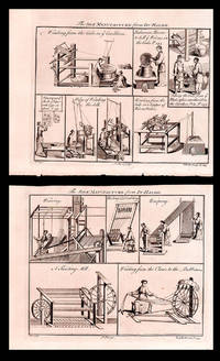
1745199414London. 1745-1747. Ten copperplate engravings arranged as storyboards on two leaves 21 x 16.5 cms border; 26 x 20 cms sheets including captions and platemark sheets a little age-toned with faint offsetting but in very good condition. Each of the ten engravings shows a stage in the production of silk. The two leaves of engravings Plates 25 and 26 were published as part of Du Halde's account of China included in an important 18th century compendium of travel writing: "A New General Collection of Voyages and Travels" known as the Astley Collection for its publisher. . hardcover
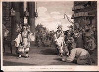
1796198465London.: G. Nicol. April 121796. Copper-plate engraving 24 x 35.3cms image; 26.7x 36.7cms sheet sheet age-toned and margins worn small chip from lower left corner not affecting the image two spots of browning in the sky very faint the image in good condition. An elegant composition after drawings by William Alexander published in Sir George Staunton's two-volume "Account of the Embassy from the King of Great Britain to the Emperor of China" published in London 1796-97. . G. Nicol. unknown
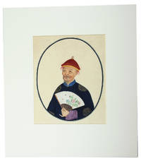
1800J76F1EWPWNYUChina 1800. In a modern gold-tooled dark green morocco clam shell box in contemporary style. Collection of 17 Chinese watercolours on Asian paper with chain lines including 3 of birds seated on a branch 3 of ensembles of fruit and flowers and 5 of fishes all ca. 30 x 37 .5 cm; 2 further watercolours each showing 2 branches of flowers and trees in a drawn oval border ca. 39 x 30 cm; and 4 watercolours of Chinese people posing with objects ca. 25 x 21 cm. Thirteen detailed Chinese watercolours of birds fruits flowers plants and fishes together with four portraits of Chinese people posing with a pipe lute flower and a handheld fan. The drawings in this album show the mixture of the Chinese and European styles that was popular in the market for export paintings in the first half of the 19th century: a combination of the Chinese approach to rendering with European aesthetics concerning light shadow and realism. As traditional in these paintings large areas of flat colour have been subtly shaded with very thin lines to draw the veins of the leaves fins of the fish and feathers of the birds. The production of these export paintings began earnestly in the 1820s and reached its height in the 1830s and 1840s especially after China's defeat in the First Opium War 1839-1842 opened the country to foreign trade. Photography was introduced in China in the 1840s and the market for export paintings declined after 1860.By the end of the 18th century Chinese painters in Hong Kong and Canton started producing paintings and drawings for European buyers. Although they were made for artistic and decorative purposes many European naturalists began collecting drawings to study Chinese plants and species. Most of the plants and animals would simply not survive the journey to Europe whereas dried specimens did not preserve the colour or shape of the flower. Most of the export paintings were ensembles of flowers and animals placed on a background. Imagination was more important than copying nature and the realistically painted flowers could have different colours or even be a composition of elements from different species. For that reason serious naturalists commissioned Chinese artists to paint according to the standards of European scientific illustration. With a few tiny spots and minor smudges but otherwise in very good condition. unknown
1730171311730. Very good condition. An early copper plate engraved b&w map extending from Egypt and the Middle East to southeast Asia with Australia at the extreme lower right "New Holland" and below that "Incognita". To the northeast is Nova Guinea drawn attached to Carpentaria. A rather crude general map of southeast Asia. Heraldic shields with author and title at the lower left. Desing was a Benedictine monk from Ensdorff & member of the Bavarian Academy of Sciences. 5 1/4 x 4 1/2" unknown
180026715Canton 1800. Large 4to. 15 x 12 1/2 inches. 141 watercolours on thin paper nearly all captioned in ink in Chinese in the lower right corner each tipped to a sheet of wove paper. Mid-nineteenth century citron half morocco over marbled paper covered boards spine with raised bands in six compartments lettered in gilt in the second compartment the others with a repeat decoration in gilt marbled edges<br/> <br/> Provenance: Annie Pearson Viscountess Cowdray née Cass 1860-1932 Dunecht House Aberdeenshire.<br/> <br/> An extraordinary album of early Chinese export watercolours of the highest quality.<br/> <br/> Beginning in the late 18th century centred on the treaty port of Canton there existed a thriving trade in ethnographical watercolours executed by local Chinese artists and sold to the western merchants and travellers. The best known result of this trade is William Mason's Costume of China first published in London in 1800 which is illustrated with 60 hand-coloured aquatints adapted from a series of original watercolours by Pu-Qua of Canton. It was common for the local artists including Pu-Qua to work from a set series of models. The present album includes a number of compositions that are from the same set of models as those used by Pu-Qua but they include more detail and more of the trade-associated paraphernalia than are shown in the images as published in Mason's work. This suggests that they were not copied from Mason but were after another more detailed source or were unique compositions by the artist based on a similar series of models. Importantly these watercolours are of a uniformly higher quality than usually encountered and represent not only a wide array of occupations but also members of the highest echelon of Chinese society. The detailing on the costumes worn by these members of the royal court is breathtaking with copious use of gilt. Later collections of Chinese export watercolours were routinely executed on less expensive pith paper whereas the present watercolours are on high quality tissue and are larger in size than those typically encountered. The album represents an earlier more prestigious style of export watercolour paintings specifically meant for wealthy Europeans. These are Chinese watercolours of the highest quality designed and executed to the highest standards. The album was once owned by Annie Pearson Viscountess Cowdray Steward of Colchester and wife of Lord Weetman Dickinson Pearson 1st Viscount Cowdray.<br/> <br/> Cf. Crossman The China Trade Princeton: 1972; cf. Clunas Chinese Export Watercolours London: 1984. unknown
179519601Leiden 1795. Very good condition. A later hand colored copper engraved map of Macao China and the islands in its vicinity. From a Dutch edition of "Cook's Voyages". On fine wove paper with full impression marks from the plate visible. Contemporary folds. 8 1/4 x 10 1/2" with margin slightly trimmed at lower left. unknown
175016021Paris 1750. Ca. 1750. Eighteenth century map of the eastern Chinese province of Chekiang with the island of Chusan and the islands of the Chusan archipelago. From Tome VI of Abbe Prevost's Historie Generale des Voyages. Includes 'Kimp-tong' island with the following note "Isles ou les Mandarins disgracies se retirent" island where disgraced Mandarins withdraw and the 'Ning-po' River. With north oriented to the right. Uncolored with compass rose. Size: 13 x 9". Very good. HK1300. unknown
1750160201750. Bellin's chart of the islands "at the mouth of the Canton River" Pearl River Delta. From the atlas Histoire Generale des Voyages. <br /> <br /> Showing parts of Lantau island Macao Isle de Macao and Ville de Macao both shown and the southeast coast of Guangdong Province Province de Quang Tong to Shangchuan and Xiachuan Islands with names of villages fresh water supplies and the tomb of St. Francis Xavier shown on the Isle de Sanciam sic. To the east are islands "Yong Ngao "que l'on appelle Les Isles des Voleurs" 'Islands of Thieves' or present day Mariana Islands. <br /> <br /> With a compass rose and an elaborate title cartouche at the lower right. 13 x 8 1/2" HK2300. unknown
173816232London: Edward Cave at St. John's Gate 1738. Very good condition. A map of the entrance to Canton with Macau Ma-kau and the islands on the approach pictured with depth soundings and an inset "Plan of Quang-Chew Fu commonly called Kanton". Copper engraved map 9 3/8 x 14 1/2" with sml margins a little ruffled with slt. margin loss. The map is from the Edward Cave folio edition of Du Halde's important encyclopedic work on Chinese culture history and society "A Description of the Empire of China and Chinese-Tartary Together with the Kingdoms of Korea and Tibet" by a French Jesuit who specialized in China. Du Halde's work inspired great interest in China among Europeans and was a ground breaking work in geography. The Du Halde book is referred to in Cordier BS 50; Löwendahl 409; Lust 15. Edward Cave, at St. John's Gate unknown