[CHINA - WATERCOLOUR].Biblio.com
73 résultats
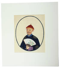
1800J76F1EWPWNYUChina 1800. In a modern gold-tooled dark green morocco clam shell box in contemporary style. Collection of 17 Chinese watercolours on Asian paper with chain lines including 3 of birds seated on a branch 3 of ensembles of fruit and flowers and 5 of fishes all ca. 30 x 37 .5 cm; 2 further watercolours each showing 2 branches of flowers and trees in a drawn oval border ca. 39 x 30 cm; and 4 watercolours of Chinese people posing with objects ca. 25 x 21 cm. Thirteen detailed Chinese watercolours of birds fruits flowers plants and fishes together with four portraits of Chinese people posing with a pipe lute flower and a handheld fan. The drawings in this album show the mixture of the Chinese and European styles that was popular in the market for export paintings in the first half of the 19th century: a combination of the Chinese approach to rendering with European aesthetics concerning light shadow and realism. As traditional in these paintings large areas of flat colour have been subtly shaded with very thin lines to draw the veins of the leaves fins of the fish and feathers of the birds. The production of these export paintings began earnestly in the 1820s and reached its height in the 1830s and 1840s especially after China's defeat in the First Opium War 1839-1842 opened the country to foreign trade. Photography was introduced in China in the 1840s and the market for export paintings declined after 1860.By the end of the 18th century Chinese painters in Hong Kong and Canton started producing paintings and drawings for European buyers. Although they were made for artistic and decorative purposes many European naturalists began collecting drawings to study Chinese plants and species. Most of the plants and animals would simply not survive the journey to Europe whereas dried specimens did not preserve the colour or shape of the flower. Most of the export paintings were ensembles of flowers and animals placed on a background. Imagination was more important than copying nature and the realistically painted flowers could have different colours or even be a composition of elements from different species. For that reason serious naturalists commissioned Chinese artists to paint according to the standards of European scientific illustration. With a few tiny spots and minor smudges but otherwise in very good condition. unknown
173816232London: Edward Cave at St. John's Gate 1738. Very good condition. A map of the entrance to Canton with Macau Ma-kau and the islands on the approach pictured with depth soundings and an inset "Plan of Quang-Chew Fu commonly called Kanton". Copper engraved map 9 3/8 x 14 1/2" with sml margins a little ruffled with slt. margin loss. The map is from the Edward Cave folio edition of Du Halde's important encyclopedic work on Chinese culture history and society "A Description of the Empire of China and Chinese-Tartary Together with the Kingdoms of Korea and Tibet" by a French Jesuit who specialized in China. Du Halde's work inspired great interest in China among Europeans and was a ground breaking work in geography. The Du Halde book is referred to in Cordier BS 50; Löwendahl 409; Lust 15. Edward Cave, at St. John's Gate unknown
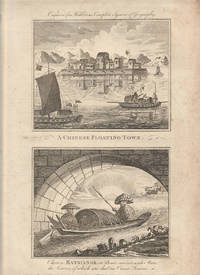
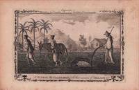
1779178310London. circa1779. A pair of engravings on a single sheet of laid paper each 14 x 15 cm including captions; 37 x 23 cm sheet the sheet with scattered spotting and toning mainly affecting the margins but in very good condition. This engraving appeared in Middleton's "New & Complete System of Geography" 1779 and is an example of the demand for publishers to supply views of the East and exotic "New Worlds". The late-seventeenth and eighteenth centuries had seen a dramatic increase in the publication of voyage accounts and compilations and collections on the London book market. <br> <br>From the Estate of the late collector and scholar Arthur Hacker. . unknown
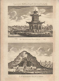
1779178311London. circa1779. A pair of engravings on a single sheet of laid paper each 13 x 16.4 cm including captions; 37 x 23 cm sheet the sheet with scattered spotting and toning mainly affecting the margins in original uncoloured state as issued in very good condition. This engraving appeared in Middleton's "New & Complete System of Geography" 1779 and is an example of the demand for publishers to supply views of the East and exotic "New Worlds". The late-seventeenth and eighteenth centuries had seen a dramatic increase in the publication of voyage accounts and compilations and collections on the London book market. <br> <br>From the Estate of the late collector and scholar Arthur Hacker. . unknown
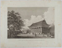
1796177641London. 1796. Large format engraving 23.9 x 35.9 cm; 35.9 x 46 cm sheet including caption and platemark spots of browning to the image affecting the sky and marginal foxing old paper abrasions to the verso the sheet a little creased and dusty but a strong dark impression in very good condition. Fine detailed engraving after a drawing by the artist William Alexander 1767-1816 of the sumptuous Hall of Audience to the Summer Palace prepared as plate 22 for the folio atlas to George Staunton's account of the Macartney Embassy to China of 1793. Staunton's commentary noted its magnificence: "Its projecting roof was supported upon two rows of large wooden columns the shafts of which were painted red and varnished; and the capitals ornamented with various scrolls and devices in vivid colouring particularly with dragons.". The engraver William Lowry 1762- 1824 specialised in architectural engravings and was later a member of the Royal Society. <br> <br>From the Estate of the late collector and scholar Arthur Hacker. . unknown
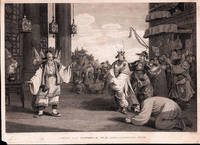
1796198465London.: G. Nicol. April 121796. Copper-plate engraving 24 x 35.3cms image; 26.7x 36.7cms sheet sheet age-toned and margins worn small chip from lower left corner not affecting the image two spots of browning in the sky very faint the image in good condition. An elegant composition after drawings by William Alexander published in Sir George Staunton's two-volume "Account of the Embassy from the King of Great Britain to the Emperor of China" published in London 1796-97. . G. Nicol. unknown
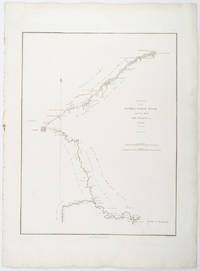
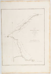
1796209283London.: George Nicol. 1796. Engraved copperplate map on Whatman paper 43.8 x 33.6 cm; 57 x 42 cm sheet including plate markscale in nautical and English miles; light undulation to sheet marginal toning and edgewear but in very good condition. Finely engraved and detailed map of two routes to Pekin Beijing along the White River Baihe from the Gulf of Petcheli and along the Imperial Highway from Jehol and includes commentary locating palaces and gardens type of cultivation "many barges" and "the road shaded by willow trees". The map elegantly drawn by Henry William Parish was published in George Staunton's account of Earl Macartney's embassy to China 1792-1794. . George Nicol. unknown
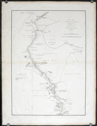
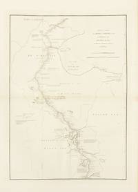
1796207049London.: George Nicol. 1796. Double-sheet engraved copperplate map 63.2 x 44.8 cm; 75 x 57 cms sheet including platemark central fold the sheet toned at the edges and central fold a couple of minor spots and edge wear but in very good condition. An exquisitely engraved map with fine detail of the route taken by George Macartney on the first official British embassy to China 1792-1794 undertaken with the aim of gaining trade concessions from the Chinese Emperor and published in George Staunton's officall account. <br> <br>While the official purpose was not successful much was learned about China and the Chinese as is evident from this map with its explanatory texts. To the west of Pekin just below the starting point at Zhe-hol Jehol which is situated at the top of this map the commentary reads: "A great part of the country around Pekin is employed in the production of culinary vegetables and a variety of fruits." At the lower edge of the map just north of the ending point of Hangzhou is the lake Tai Hoo: "The western side of the Tai-hoo is bounded by a very romantic and fertile country whose mountains are clutivated to their very tops. A great part of the province of Tche-tchiang appears to be cultivated with Mulberry trees for the food of the Silk worms." Cities of the 1st 2nd and 3rd orders "considerable towns" and villages are marked along with "Halting places" etc. Fascinating Western documentation of the area around the Imperial Canal of the late Eighteenth Century. . George Nicol. unknown
1796197217London.: George Nicol. 1796. Engraved copperplate map on Whatman paper 43.8 x 33.6 cm; 57 x 38.5 cm sheet scale in nautical and English miles; light undulation to sheet marginal toning and edgewear a couple of rust spots to the blank of the map's lower corner trimmed to the border on the inner margin but in very good condition. Finely engraved and detailed map of two routes to Pekin Beijing along the White River Baihe River from the Gulph of Petcheli and along the Imperial Highway from Jehol and includes commentary locating palaces and gardens type of cultivation "many barges" and "the road shaded by willow trees". The map elegantly drawn by Henry William Parish was published in George Staunton's account of Earl Macartney's embassy to China 1792-1794. . George Nicol. unknown
1796143663London: George Nicol 1796. Very Good. London George Nicol April 12th 1796. A large engraved map printed surface 640 × 451 mm sheet size 812 × 557 mm. Engraved by B. Baker. Horizontal centrefold crease as issued; occasional spots of foxing mainly in the margins; two small faint stains to the left-hand margin well clear of the printed surface; old guard on the verso with some light associated tanning on the recto about the fold; in excellent condition with wide margins. John Barrow later first Baronet was attached to the first British diplomatic mission to China led by George Macartney in 1792-94. The map is plate 9 from the atlas to the official account of the embassy George Staunton's 'An Authentic Account of an Embassy from the King of Great Britain to the Emperor of China .'. <p>The journey shown here was from Chengde formerly Jehol to Beijing and then south to Hangzhou along the Grand Canal. While Macartney failed to secure any concessions from the Qianlong Emperor the expedition nevertheless collected important information about the geography culture population and politics of the Chinese Empire. George Nicol unknown
1788314738Paris: chez l'auteur . et chez Ponce 1788. First editions. Vol 1: Title 24 plates and 24 leaves of text; vol 2: title dedication 24 plates and 24 leaves of text. 4to. Contemporary green morocco with gilt Greek key borders pink silk endpapers a.e.g. Corners rubbed spine a touch browned marginal foxing in first volume and to a few leaves in second. First editions. Vol 1: Title 24 plates and 24 leaves of text; vol 2: title dedication 24 plates and 24 leaves of text. 4to. First editions beautifully and fully engraved. The first volume is on the life of Confucius the second details notable events in the reigns of various Chinese emperors. The plates were made after a series of drawings by the Jesuit missionary Joseph Marie Amiot. Cohen-De Ricci 479; Lust 729 1133. Provenance: Francis John Hughes bookplate chez l'auteur ... et chez Ponce unknown
180026715Canton 1800. Large 4to. 15 x 12 1/2 inches. 141 watercolours on thin paper nearly all captioned in ink in Chinese in the lower right corner each tipped to a sheet of wove paper. Mid-nineteenth century citron half morocco over marbled paper covered boards spine with raised bands in six compartments lettered in gilt in the second compartment the others with a repeat decoration in gilt marbled edges<br/> <br/> Provenance: Annie Pearson Viscountess Cowdray née Cass 1860-1932 Dunecht House Aberdeenshire.<br/> <br/> An extraordinary album of early Chinese export watercolours of the highest quality.<br/> <br/> Beginning in the late 18th century centred on the treaty port of Canton there existed a thriving trade in ethnographical watercolours executed by local Chinese artists and sold to the western merchants and travellers. The best known result of this trade is William Mason's Costume of China first published in London in 1800 which is illustrated with 60 hand-coloured aquatints adapted from a series of original watercolours by Pu-Qua of Canton. It was common for the local artists including Pu-Qua to work from a set series of models. The present album includes a number of compositions that are from the same set of models as those used by Pu-Qua but they include more detail and more of the trade-associated paraphernalia than are shown in the images as published in Mason's work. This suggests that they were not copied from Mason but were after another more detailed source or were unique compositions by the artist based on a similar series of models. Importantly these watercolours are of a uniformly higher quality than usually encountered and represent not only a wide array of occupations but also members of the highest echelon of Chinese society. The detailing on the costumes worn by these members of the royal court is breathtaking with copious use of gilt. Later collections of Chinese export watercolours were routinely executed on less expensive pith paper whereas the present watercolours are on high quality tissue and are larger in size than those typically encountered. The album represents an earlier more prestigious style of export watercolour paintings specifically meant for wealthy Europeans. These are Chinese watercolours of the highest quality designed and executed to the highest standards. The album was once owned by Annie Pearson Viscountess Cowdray Steward of Colchester and wife of Lord Weetman Dickinson Pearson 1st Viscount Cowdray.<br/> <br/> Cf. Crossman The China Trade Princeton: 1972; cf. Clunas Chinese Export Watercolours London: 1984. unknown
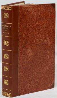
1797035987London: G. Nicol 1797. 1st Edition 1st Printing. Hardcover. Very Good . 11 1/8" Tall. Frontispieces Plates And Illustrations. Ii Xxxiv518; Ii Xx 626. The Two Complete Text Volumes In Full Size Text Blocks 10 5/8" Tall; The Plates Were Issued 1796 In A Separate Volume Not Present Here; But The Plate Of The Camellia Sesanqua Is Present Between Pp 466 And 467. Original Quarter Morocco Binding Five Bands Morocco Spine Labels Over Boards Covered With Marbled Paper Original Off-White Endpapers Preliminary And Final Blank In Each Volume. Bindings With Old Wear But Nicely Furbished Morocco Labels Clean With Brilliant Gilt A Little Loss Of Leather At Tops Of Spines And At Top Right Front Spine Edge Paper Frayed Along All Edges Of Boards Hinges Tight Contents Clean Just A Few Tiny Foxing Spots. Small Very Old Booksellers' Label Of The China Times Bookseller 94 Consular Road Tientsin. And Another From Sydney. Former Owner's Signature Dated 1894 Erased In Volume 1 Of George Ernest Morrison And A Few Marginalia Which Appear To Be His; George Ernest "G. E." Morrison 1862 - 1920 Also Known As Morrison Of Peking Or Chinese Morrison Was An Australian Adventurer Appointed In February 1897 As The Times Correspondent In Peking Despite His Lack Of Knowledge In The Chinese Language. He Traveled To Vladivostok And Reported To The Times That Russian Engineers Were Making Preliminary Surveys From Kirin Towards Port Arthur Then Sent A Telegram To Say That Russia Had Presented A Five-Day Ultimatum To China Demanding The Right To Construct A Railway To Port Arthur. This Was A Triumph For The Times And Its Correspondent But He Had Also Shown Prophetic Insight In Another Phrase Of His Dispatch When He Stated That "The Importance Of Japan In Relation To The Future Of Manchuria Cannot Be Disregarded". After A Visit To Siam And England Then To Australia 1899-1900 He Returned To Peking. When The Boxer Uprising Broke Out And During The Siege Of The Legations From June To August Morrison As An Acting-Lieutenant Showed Great Courage Always Ready To Volunteer For Every Service Of Danger. After A Siege Of 55 Days The Legations Were Relieved By A Multinational Force Which Then Ransacked Much Of The Palaces In Peking With Morrison Taking Part In The Looting. There Was Great Uncertainty Regarding The Future Of China In The Following Months And Through The Times Morrison Managed To Depict A Skewed Picture Before The British Public. While Russia And Japan United In Opposing Any Dismemberment Of China The Country Was Nevertheless Punished By The Imposition Of A Heavy Indemnity. In 1904 Morrison Became A Correspondent With The Japanese Army. He Was Present At The Entry Of The Japanese Into Port Arthur Early In 1905 And Represented The Times At The Usa Peace Conference. In 1907 He Crossed China From Peking To The French Border Of Tonkin And In 1910 Rode From Honan Across Asia To Russian Turkestan. From Andijan He Took A Train To St Petersburg And Then Traveled To London Arriving On 29 July 1910. A Great Chinese Physician Dr. Wu Lien-Teh Succeeded In Staying The Spread Of This Mortal Sickness Which Seemed To Threaten The Whole World. Morrison Published A Series Of Articles Advocating The Launching Of A Modern Scientific Public Health Service In China. When The Chinese Revolution Began In 1911 Morrison Took The Side Of The Revolutionaries. In August Morrison Resigned His Position On The Times To Become Political Adviser To The Chinese Government And Immediately Went To London To Assist In Floating A Chinese Loan Of £10 Million. In China During The Following Years He Had An Anxious Time Advising And Endeavoring To Deal With The Political Intrigues That Were Continually Going On. He Visited Australia Again In December 1917 And Returned To Peking In February 1918. He Represented China During The Peace Discussions At Versailles In 1919 But His Health Began To Give Way And He Retired To England Well Aware That He Had Only A Short Time To Live. He Died On 30 May 1920 . A Nice Historical Association. Later Ownership Signatures Of G B Wilson. <br/> <br/> G. Nicol hardcover
1797223222London.: Printed for John Stockdale Piccadilly. 1797. 2 folding maps 30 copper plate engravings including engraved title page 6 xv 475pp 2 Errata and Directions to the Binder 3 publisher's advertisements; recent half calf early mottled-papered boards spine gilt decorated and lettered to style flecked fore edges 22 x 13.5cm boards a little rubbed the text age-toned and the plates with marginal foxing previous owner's bookplate to the front pastedown and the neat inscription of three others to the prelims a very good copy of the octavo edition. Handsome copy of the abridged octavo edition of Lord Macartney's voyage and embassy to China 1792-4 by his secretary and "Minister Plenipotentiary in the absence of the Ambassador" George Staunton. Many of the illustrations are after drawings by William Alexander whose "views remained unrivalled until the era of photography" Lowendahl. . Printed for John Stockdale, Piccadilly. hardcover
173816720London: Edward Cave at St. John's Gate 1738. Very good overall. Copper engraving 8 1/2 x 13 1/4". Floorplans of two temples from the Edward Cave folio edition of this important encyclopedic work on Chinese culture history and society by a French Jesuit who specialized in China. Du Halde's work inspired great interest in China among Europeans and was a ground breaking work in geography. The book: Cordier BS 50; Löwendahl 409; Lust 15. Edward Cave, at St. John's Gate unknown
1730171311730. Very good condition. An early copper plate engraved b&w map extending from Egypt and the Middle East to southeast Asia with Australia at the extreme lower right "New Holland" and below that "Incognita". To the northeast is Nova Guinea drawn attached to Carpentaria. A rather crude general map of southeast Asia. Heraldic shields with author and title at the lower left. Desing was a Benedictine monk from Ensdorff & member of the Bavarian Academy of Sciences. 5 1/4 x 4 1/2" unknown
175016021Paris 1750. Ca. 1750. Eighteenth century map of the eastern Chinese province of Chekiang with the island of Chusan and the islands of the Chusan archipelago. From Tome VI of Abbe Prevost's Historie Generale des Voyages. Includes 'Kimp-tong' island with the following note "Isles ou les Mandarins disgracies se retirent" island where disgraced Mandarins withdraw and the 'Ning-po' River. With north oriented to the right. Uncolored with compass rose. Size: 13 x 9". Very good. HK1300. unknown
177521534Paris 1775. Very good condition. Detailed copper engraved map of northeast Asia and Siberia from Lake Baykal sic Partie du Siberie in the north Pays des Kalkas at the center as well as Desert de Sable and down to Chine and the Golphe de Lyau-tong. From Prevost's "L'Histoire Generale des Voyages".<br /> <br /> Bellin 1703 - 1772 one of the most noted French mapmakers of the 18th century was named the hydrographer chief cartographer to the French Navy and later the Official Hydrographer to the French King. <br /> <br /> 12 3/4 x 9 1/4" original center fold. Strong impression very clean. unknown
177521532Paris 1775. Very good condition. Detailed copper engraved map of northeast Asia and Manchuria showing the island "Sagallan Anga Hata" or "Isle de Bouche Noire". From Prevost's "L'Histoire Generale des Voyages".<br /> <br /> Bellin 1703 - 1772 one of the most noted French mapmakers of the 18th century was named the hydrographer chief cartographer to the French Navy and later the Official Hydrographer to the French King.<br /> <br /> 12 1/2 x 8 3/4" original center fold. Strong impression very clean. unknown
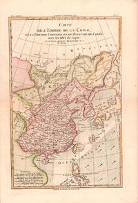
1780180203Paris. circa1780. Engraved handcoloured map 31.3 x 20.5 cm; 37.8 x 25.5 cm sheet central fold slight toning one spot of discolouration to the upper border in very good crisp condition. Attractive map showing China the Korean peninsula the Philippines Japan and Chinese Tartary/Mongolia Vietnam and Central Asia. Also shows the wind direction vital to traders at the time. Rigobert Bonne 1727-1794 was an influential French cartographer of the late-eighteenth century succeeding Jacques Nicolas Bellin as Royal Hydrographer at the Depôt de la Marine in 1773. This map was prepared for Abbe Raynal’s famous "Atlas de Toutes Les Parties Connues du Globe Terrestre." 1780. . unknown
1750160201750. Bellin's chart of the islands "at the mouth of the Canton River" Pearl River Delta. From the atlas Histoire Generale des Voyages. <br /> <br /> Showing parts of Lantau island Macao Isle de Macao and Ville de Macao both shown and the southeast coast of Guangdong Province Province de Quang Tong to Shangchuan and Xiachuan Islands with names of villages fresh water supplies and the tomb of St. Francis Xavier shown on the Isle de Sanciam sic. To the east are islands "Yong Ngao "que l'on appelle Les Isles des Voleurs" 'Islands of Thieves' or present day Mariana Islands. <br /> <br /> With a compass rose and an elaborate title cartouche at the lower right. 13 x 8 1/2" HK2300. unknown
173816698London: Edward Cave at St. John's Gate 1738. Very good overall. Copper engraving 11 x 8 3 3/4" with margins. Map from the Edward Cave folio edition of this important encyclopedic work on Chinese culture history and society by a French Jesuit who specialized in China. Du Halde's work inspired great interest in China among Europeans and was a ground breaking work in geography. The book: Cordier BS 50; Löwendahl 409; Lust 15. Sml. closed tear repaired into print at top. Edward Cave, at St. John's Gate unknown
1782178309London. circa1782. Engraving on laid paper 19 x 28.8 cm platemark including caption; 24.5 x 37 cm sheet decorative border edge tears and toning and occasional spotting but in very good condition. This engraving appeared in Millar's "New complete & Universal System of Geography" and is an example of the demand for publishers to supply views of the East and exotic "New Worlds". The late-seventeenth and eighteenth centuries saw a dramatic increase in the publication of voyage accounts and compilations and collections on the London book market. <br> <br>From the Estate of the late collector and scholar Arthur Hacker. . unknown
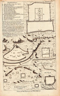
1738206300London. 1738. Five engraved architectural plans and a key together 36 x 21.6 cms; 40.2 x 25.3 cms sheet age-toning small tide-mark affecting an upper corner but overall in very good condition. Attractive group of engravings depicting walled cities of the Chinese Qing dynasty province of Pe-Che-Li today Zhili province. The engravings show a plan of Peking with a key at left; Yung-ping-fu Guangfu; Long-men-hyen Luoyang; Chin-ting-fu; and a "Plan of part of the great wall on the Side of Yung-ping-fu flank'd by several fortresses." This is a plate from an English edition of Jean Baptiste Du Halde's encyclopedic compendium of the written accounts of some 27 Jesuits in China documenting the history and customs of the country. . unknown
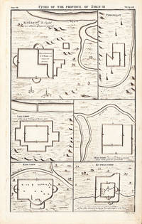
1738206290London. 1738. Six engraved architectural plans together 36 x 21.6 cms; 40.2 x 25.3 cms sheet age-toning short edge tear at lower corner soft creasing at upper left corner very good condition. An attractive suite of engravings depicting six walled cities of the Chinese Qing dynasty province of Shen-si now Shaanxi in northwestern China : Si-ngan-fu Xi'an Chwang-lan Zhuanglang Lan-chew Lanzhou Kan-chew Ing-chew and Ku-ywen Chew. This is a plate from an English edition of Jean Baptiste Du Halde's encyclopedic compendium of the written accounts of some 27 Jesuits in China documenting the history and customs of the country. . unknown