3 résultats
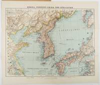
1900218968Glogau.: Verlag von Carl Flemming. Eleventh Edition. Circa1900s. Edited from the latest Russian English French and German sources by A. Herrich. Folding colour map 35 x 46cm folding to 25 x 14cm in original printed wrappers with a small loss to the edge of the lower wrapper otherwise very good copy. . Verlag von Carl Flemming unknown
1873168911873. Original Map Asia: China Korea Thailand India Taiwan Malaisia Kuwait Arabia 1873 With The Title "Asia" in the left corner. Origin of the Map is from the "Stieler's Hand-Atlas." continent-based upon von Stulpnagel published in Gotha by Justus Perthes. Germany. Beautifully Hand Colored. Date of issue: 1873. Size: The sheet measures aprox 18 in x 15 in or 45 x 37 cm. Overall very good condition. unknown
1851200120AG1851. London Edinburgh & Dublin J.& F. Tallis 1851. Original steel engraving / Vintage map. Drawn and engraved by John Rapkin. Partly hand-coloured. Illustrations by H. Warren and Enrgaved by J.H. Kernot. Plate Size: 33 cm x 25.5 cm. Sheet Size: 37.4 cm x 27.3 cm. Vintage 19th century map in very good condition. Published in the Illustrated Atlas And Modern History Of The World Geographical Political Commercial & Statistical Edited By R. Montgomery Martin. Beautifully bordered and fascinating map of Japan and Korea. The names of the major islands of Japan - Kiosiou Sitkokfi Shikoku and Niphon Honshu and the southern tip of 'Matsmai or Yersqi' Hokkaido are included on the map. Below the elbow of Honshu can be seen the tiny island of Fatsisio - the 'place of exile for the Grandees of Japan.' The map's nomenclature is interesting: Tokyo not yet the capital is named as Yedo while the then-capital Kyoto appears as 'Meaco'. Across the Korean Strait modern Seoul appears as 'Han y'. As these maps were being published both of these ancient and distinctive states Korea - the 'Hermit Kingdom' - and Japan - isolated under the centuries' long under the sakoku policy - were having to acclimate to increased Western influence in their region. The 1853-54 U.S. diplomatic and military naval expedition under Commodore Perry would force the establishment of diplomatic relations between Japan and the western "Great Powers" and eventually to the collapse of the ruling Tokugawa shogunate and the Meiji Restoration. Japan would partially embrace the West and western influences and emerge as a burgeoning regional power eventually establishing control over Korea by the early 20th century - at the beginning a calamitous half-century for the region. John Tallis 7 November 1817 3 June 1876 was an English cartographic publisher. His company John Tallis and Company published views maps and atlases in London from roughly 1838 to 1851. Tallis set up as a publisher with Frederick Tallis in Cripplegate in 1842; the business moved to Smithfield in 1846 and was dissolved in 1849. From 1851 to 1854 Tallis operated as John Tallis and Company. He started The illustrated news of the world and national portrait gallery of eminent personages in 1858 selling it for £1370 in 1861; it folded in 1863. Wikipedia The most important project John Tallis undertook was the 'Illustrated Atlas' from 1851. The original map we offer here was part of this exceptional Atlas and all the maps it contained are still today considered as the last reminder of an era of lavish map production. Tallis worked the project together with John Rapkin 1815-1876 and it was Rapkin's style and talent that we have to thank for when we marvel at these maps today. What makes these maps so special is the detail of engraved vignettes that surround the map and often show indigenous scenes people in their environment and even more so historical buildings or historical views of towns and cities architecture and landscape. The project of 'The Illustrated Atlas' was designed to be finished just in time for the anxiously awaited "Great Exhibition of the Works of Industry of All Nations" or The Great Exhibition sometimes referred to as the Crystal Palace Exhibition in reference to the temporary structure in which it was held was an international exhibition that took place in Hyde Park London from 1 May to 11 October 1851. It was the first in a series of World's Fairs exhibitions of culture and industry that became popular in the 19th century and it was a much-anticipated event. The Great Exhibition was organized by Henry Cole and Prince Albert husband of the reigning monarch Queen Victoria. It was attended by numerous notable figures of the time including Charles Darwin Samuel Colt members of the Orléanist Royal Family and the writers Charlotte Brontë Charles Dickens Lewis Carroll George Eliot and Alfred Tennyson. Music for the opening was under the direction of Sir George Thomas Smart and the continuous music from the exhibited organs for the Queen's procession was "under the superintendence of William Sterndale Bennett". Wikipedia unknown
