3 résultats
1869102888Paris: Librairie L. Hachette et Co. 1869. 717 pp includes index. Avec une carte routiere generale. Quatorze cartes speciales et treize plans de villes. Deuxieme edition entierement refondue. Descriptif et historique. Includes Hachette's Collection des guides-Joanne. Appendice added: 1872-1873 Services Maritimes Chemins de fer Francais & etrangers Telegraphie Compagnies Financieres Compagnies D'assurances. Wonderful b/w illustrated ads some showing grand old hotels and resorts. Fold-out map in pocket at back is complete though has a separation along fold from age. Navy cloth on boards binding has bright gold lettering to front some sun fading to spine some edgewear to spine and bumps to back corners. Front free endpaper is missing. Title page has circular stamp stating Seine Colportage. Text has some dust soiling to pages' edges but is very nice complete and secure. Table of contents has some pen checks. Hardcover. Fair/No Jacket. 7 1/8 x 4 7/8. Librairie L. Hachette et Co. Hardcover
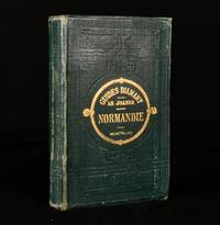
1882726P7Paris: Hachette et Cie 1882. Cloth. Very Good. 5.5" by 3.5". Not Stated. Unusually good condition for this French travel work on Normandy illustrated lavishly throughout with six detailed folding maps. In the original French.Part of Adolphe Joanne's extensive geographical publications and his condescend 'Guides Diamant' series this volume focusing on Normandy.Illustrated with six folding maps.Joanne was a prolific author of travel books.Forty-four pages of publisher's adverts to the front seventy-two pages of publisher's adverts to the rear. In the original publisher's cloth binding. Externally generally smart. Light rubbing to the boards and spine. Minor bumping to the head and tail of the spine and to the extremities. Front hinge is starting but firm. Internally generally firmly bound. Pages are bright and clean. Light edgewear to the folding map facing page 146. Very Good Hachette et Cie hardcover
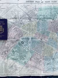
186773669Paris: Hachette 1867. Fine. Hachette Paris 1867 11 x 17.80 cm relié Collection des guides Joanne series. Alphabetical list of Paris streets with also the list of omnibuses and their routes fares mobile carriages and other public transport. Publisher's binding in full purple cloth. Smooth unlettered spine. Title and arms of Paris on the first cover. Large folding map of Paris in colors. Several small tears. Handsome copy. The Paris of Napoleon III and Haussmann. This map of Paris was published for the 1867 Paris Universal Exhibition. At the end of the chapter on public carriages one reads: ""A special service from Place du Palais-Royal to Pont d'Iéna will operate throughout the duration of the exhibition"". Hachette hardcover