Biblio.com
13 résultats
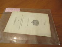
1862030663Kjobenhavn Copenhagen: J H Schultz 1862. 1st Edition . Soft cover. Near Fine. 11 Pp. Original Printed Wrappers No Names Or Marks Minute Loss At Lower Tips Of Cover And First Page. Ex Copley Library Although Not Marked As Such. <br/> <br/> J H Schultz paperback
185421221Boston: Phillips Sampson and Company. 1854. Early edition. Hardcover. Very Good-. Boards with moderate wear to extremities. Minute tears to spine ends. Spine a bit slanted. Former owner's name on front free endpaper. The slightest of foxing to the first and last few pages. ; "Being a political historical and statistical amount of the island from it first discovery to the present time". Author Ballou was from Boston and later worked as the first editor for the Boston Globe. He was an extensive traveler and this book was his second one on Cuba and his second travel book. Before he wrote travel books he had a career as a fiction writer. ; B&W Illustrations; 12mo 7" - 7½" tall; viii 230 10 pages . Phillips, Sampson and Company hardcover
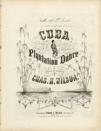
1855List3682Philadelphia: Edward L. Walker 142 Chestnut St. above 6th 1855. Folio sheet music pictorial lithographed cover approximately 13.5 × 10.5 inches. Light edge wear and minor toning; very good with a strong impression of the cover illustration. An antebellum piano dance reflecting the plantation imagery that circulated widely in mid-nineteenth-century American popular music. “Cuba Plantation Dance†was composed by Chas. H. Wilson a little-documented composer whose name appears chiefly in connection with this work and issued in Philadelphia during the early 1850s by Edward L. Walker the predecessor firm to the major publishing house Lee & Walker. A copy is recorded in the Levy Collection at Johns Hopkins which dates the publication to 1855.<br /> <br /> The cover presents a stylized plantation landscape framed by tall stalks of sugar cane with a small central vignette of a dancing Black figure. The use of Cuban plantation imagery reflects contemporary American fascination with the Caribbean sugar economy and with plantation life beyond the United States. During the 1850s Cuba was one of the largest slave societies in the Atlantic world. By the midcentury the island’s sugar plantations relied on hundreds of thousands of enslaved Africans and the enslaved population of Cuba was estimated at roughly 400000 people in the 1840s–1850s working primarily in the rapidly expanding sugar industry. Although Spain formally agreed to end the Atlantic slave trade in 1820 illegal importations of enslaved Africans into Cuba continued for decades supplying labor for the island’s plantations well into the 1850s. American publishers frequently borrowed such imagery for plantation-themed dance music marketed to the parlor trade. Pieces labeled “plantation dances†or “Ethiopian dances†formed part of the broader culture of minstrel and plantation entertainment. The title page bears a dedication to “Miss Arabelle Conrad†typical of mid-century sheet music addressed to amateur pianists. Along with the aforementioned copy in the Levy collection we find copies at Michigan and Temple. Edward L. Walker, 142 Chestnut St., above 6th unknown
18290005575Boston: Bowles and Dearborn 1829. First edition. Hardcover. Good. Octavo xv 256pp. original quarter linen & boards untrimmed 250mm x 145mm chipped paper label on spine shaken inked name on free endpaper needs some resewing. <br/><br/>Rev. Abbot went to Cuba to restore his fragile health. This eloquent Harvard graduate then traversed a thousand miles on horseback through Sumidero and Lemonal Matanzas a week in Havana etc. "The pictures he has given are of things which were immediately before him as exact in circumstances and as true to the life as his pencil could pourtray; and the statement of facts is correct according to his convictions - Preface." Sabin 14; Palau 519; Shaw & Shoemaker 37345. Abbot died on his return trip before reaching his Massachusetts home. Bowles and Dearborn hardcover
1851200111AG1851. London & New York J & F. Tallis 1851. Original steel engraving / Vintage map. Drawn and engraved by John Rapkin. Partly hand-coloured. Illustrations by H. Warren and Engraved by J. Rogers. Plate Size: 25 cm x 35 cm. Sheet Size: 27 cm x 37.4 cm. Vintage 19th century map in very good condition. A beautiful map of the West Indies: from the Bahamas in the North near the southern tip of Florida down to Barbados and Trinidad of the coast of Colombia. Cuba Jamaica Hispaniola San Domingo and Haiti Porto Rico the Virgin Islands and the myriad of smaller islands throughout the Caribbean Sea are also included. The Mosquito Coast in modern Nicaragua Guatemala and the Panama isthmus can also be seen. Relief depicted with hachuring. The major towns and cities across this region such as Havana Kingston and Port Royal Port Republican Port-au-Prince and Cartagena are also shown. A depiction of native peasants and a medallion complete this pleasant map. John Tallis 7 November 1817 3 June 1876 was an English cartographic publisher. His company John Tallis and Company published views maps and atlases in London from roughly 1838 to 1851. Tallis set up as a publisher with Frederick Tallis in Cripplegate in 1842; the business moved to Smithfield in 1846 and was dissolved in 1849. From 1851 to 1854 Tallis operated as John Tallis and Company. He started The illustrated news of the world and national portrait gallery of eminent personages in 1858 selling it for £1370 in 1861; it folded in 1863. Wikipedia The most important project John Tallis undertook was the 'Illustrated Atlas' from 1851. The original map we offer here was part of this exceptional Atlas and all the maps it contained are still today considered as the last reminder of an era of lavish map production. Tallis worked the project together with John Rapkin 1815-1876 and it was Rapkin's style and talent that we have to thank for when we marvel at these maps today. What makes these maps so special is the detail of engraved vignettes that surround the map and often show indigenous scenes people in their environment and even more so historical buildings or historical views of towns and cities architecture and landscape. The project of 'The Illustrated Atlas' was designed to be finished just in time for the anxiously awaited "Great Exhibition of the Works of Industry of All Nations" or The Great Exhibition sometimes referred to as the Crystal Palace Exhibition in reference to the temporary structure in which it was held was an international exhibition that took place in Hyde Park London from 1 May to 11 October 1851. It was the first in a series of World's Fairs exhibitions of culture and industry that became popular in the 19th century and it was a much anticipated event. The Great Exhibition was organized by Henry Cole and Prince Albert husband of the reigning monarch Queen Victoria. It was attended by numerous notable figures of the time including Charles Darwin Samuel Colt members of the Orléanist Royal Family and the writers Charlotte Brontë Charles Dickens Lewis Carroll George Eliot and Alfred Tennyson. Music for the opening was under the direction of Sir George Thomas Smart and the continuous music from the exhibited organs for the Queen's procession was "under the superintendence of William Sterndale Bennett". Wikipedia unknown
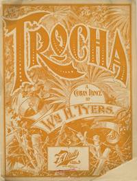
1890List3666New York: Jos. W. Stern & Co 1890. Folio sheet music illustrated pictorial cover printed in orange. 5 pp. including cover. Approximately 13 ½ x 10 ½ inches. Covers detached loss to front cover contents complete fair to good. A decorative late nineteenth-century dance publication for “Trocha†described on the cover as “A Cuban Dance†composed by the African American composer and bandleader W. H. Tyers. The elaborate pictorial cover incorporates stylized tropical foliage and island scenery rendered in a bold single-color design typical for the period’s fascination with exoticized musical forms. <br /> <br /> William H. Tyers 1870–1924 was an African American composer arranger and bandleader active in New York during the ragtime era. Born in Petersburg Virginia to Henry Tyers and Jane “Jennie†Jones both formerly enslaved he spent part of his youth in Richmond before his family relocated to New York City where he began studying piano. His early teachers recognized an aptitude for composition as well as performance and by the mid-1880s he was writing dance pieces including polkas and waltzes. Around the age of twenty Tyers secured employment as a music librarian and arranger with a touring concert company a position that brought him to Europe where he studied orchestration and arranging with Professor Gaspari in Hamburg.<br /> <br /> Returning to New York Tyers became active in the city’s rapidly expanding popular music trade working as an arranger and composer for publishers including F. A. Mills and Jos. W. Stern & Co. In 1896 he published “Sambo†a syncopated march sometimes considered to be one of the first instrumental rags.1 “Trocha†also released in the 1980s brought Tyers prominence for his ability to write Latin-style rhythms. It was re-issued in 1913 as a tango and its success led Tyers to work as an arranger with Joseph W. Stern in 1897.<br /> <br /> Tyers’ compositions blended contemporary American dance music with Caribbean and Latin themes a style reflected in pieces such as Trocha and later in his well-known ragtime composition Panama 1911 which remained a staple of early jazz and dance orchestras. OCLC finds two copies with different entries at the Cleveland Public Library and the British Museum Reference Collections. <br /> <br /> 1 “William Tyers Music Arranger†African American Registry https://aaregistry.org/story/william-tyers-born/ accessed March 10 2026. Jos. W. Stern & Co unknown
1821200023AG1821. Paris Brué 1821. Original engraving. Plate Size: 50.5 cm x 36.1 cm. Sheet Size: 68 cm x 54.1 cm. Original map. Very good condition. Extra wide margins. Some minor foxing along sheet edges. Discreet author's blind stamp with 'Carte Encyprotipe' and initials 'AB' embossed in top corner of map. Centre-fold as issued. Border with longitudinal and latitudinal information. Detailed early map of the Caribbean from an early edition of Brue's Atlas Universel Pl.35. Rich detail in Florida the Gulf Coast Central America. The eye is drawn to Cuba among the islands of the 'Grandes' and 'Petites' Antilles. As demonstrated by the map's political divisions and colourings Mexico has yet cede control of what will become Texas. Nouva Espagne and Nouv Grenade show that the aged and tottering Spanish empire has still to fall in Central and South America. The division of Hispaniola into its Haitian and Dominican parts is also shown. The great port cities of the infant United States - Charlestown Savannah and New Orleans - can be seen along the seaboard. Bermuda is shown breaching the map's top border. Reference keys and explanatory annotations and four scale-bars in lower left corner of map. Decorative title in top right corner of map. Adrien-Hubert Brué 1786 - 1832 was a renowned French cartographer. Between 1810 and 1830 Brué established himself as one of the most important French cartographers and it was during this period that his two most important works were published: Grand Atlas Universel in 1815 and Atlas Universel in 1822 which ran to several editions. Atlas Universel was published as a continuation to Grand Atlas Universel. Brués maps or cards as they were referred to at the time were characterized by the high degree of accuracy with which they were produced and the meticulous attention to detail employed in their crafting. This was possible due to Brués application of copper plate intaglio to the process of mapmaking or as Nouvelles Annales des Voyages et des Sciences Géographiques had it: by applying to the making of cards this ingenious process of drawing on copper itself. Alexandre von Humboldt the President of the Société de géographie de Paris praised the accuracy of his work and clarity that is all the more pleasing to the eye. He also was quick to update his maps with the latest scientific discoveries and nautical measurements. Wikipedia unknown
1853604771853. London: Printed by W. Clowes and Sons 1853. London: Printed by W. Clowes and Sons 1853. The First Compilation of the Laws of St. Lucia Saint Lucia. Laws at Present in Force in the Island of St. Lucia. London: Printed by W. Clowes and Sons 1853. vi 388 pp. Octavo 9-1/2" x 6". Contemporary calf with early rebacking red and black lettering pieces and small paper location label to spine upper lettering piece and endpapers renewed. Moderate rubbing to extremities some scuffing and edgewear to boards gilt red and black lettering pieces light toning to text internally clean. Ex-library. Old shelf label at head of spine small embossed stamps to boards inkstamp Bibliothek des Reichsgerichts to title page. A solid copy of a scarce title. $450. With index and side-notes. Saint Lucia was discovered by Columbus in 1502. The first group of colonists from England were massacred by the Caribs but the French succeeded in colonizing the island in 1642. It passed between France and Great Britain a number of times and became a British possession in 1803. It became independent and joined the Commonwealth in 1979. As one would suspect traces of French law remain in the island's legal system. The Reichsgerichtsbibliothek Imperial Court of Justice Library was at its peak Germany's largest and most important law library with 170000 works in its collection before the outbreak of the First World War. OCLC locates 9 copies in North America. Sweet & Maxwell A Legal Bibliography of the British Commonwealth 7:341. unknown
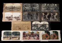
1890231711890. Stereoview archive of the post-emancipation Caribbean showing how the islands were marketed to western viewers through plantation labor export agriculture civic spectacle and catastrophe. As a group these photos function not only as an ethnographic travel archive but as evidence of the visual economy that followed slavery. The British West Indies moved through emancipation in 1834 to 1838 the French Caribbean in 1848 Puerto Rico in 1873 and Cuba in 1886 yet plantation production remained central to regional life well into the early twentieth century. These stereoviews preserve a colonial way of seeing in which Black and Afro-Caribbean labor rural discipline and extractive agriculture remained the background condition of "tropical" beauty and commercial modernity. Cuba's sugar economy in particular expanded through the nineteenth century and slavery was not abolished there until 1886 while Weyler's later reconcentration policy during the Cuban War of Independence violently reorganized rural life. Martinique after 1848 likewise shifted into new labor regimes including imported workers from India and China.<br /> <br /> Archive of 11 stereoview cards late 1890s to early 1900s depicting Cuba Jamaica Martinique Puerto Rico and the Dominican Republic. Most black and white with a few colorized. Each measure 3.5" x 7". All with captions on the margins. "Reconcentrado Farming Scene Province of Havana Cuba" links agricultural production to the brutal displacements of Spain's reconcentration campaign; "Cutting sugar cane Montego Bay Jamaica W.I." records cane labor in a colony where emancipation had not ended plantation dependency; and "Harvesting Coconuts Porto Rico" likewise frames Caribbean land through export work rather than local life. Other views extend that economic framing through cacao and coffee scenes while the paired Havana cards shift into urban leisure and public display including "Beautiful Central Park Havana Cuba" and "Holiday in Havana Cuba" the latter with both Cuban and American flags visible a telling image of the new imperial order after 1898. The disaster views from Martinique and the Lesser Antilles show how stereoview publishers also turned Caribbean destruction into consumable spectacle. the Morne Rouge card is accompanied on the reverse by the grim printed text "Dead bodies which were to be seen in Morne Rouge." while the wider context is the 1902 eruptions of Mount Pelée in Martinique and La Soufrière on Saint Vincent two catastrophes that killed roughly 30000 and 1600 people respectively and devastated local communities and agriculture.<br /> <br /> Some corner wear light toning scattered surface and edge wear. Overall very good condition. This collection gives direct visual representation of Caribbean history Atlantic slavery and emancipation plantation labor and U.S. imperial expansion in the circum-Caribbean preserving the transition from slavery to post-abolition labor. unknown
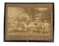
1890208021890. Unidentified photographers two albumen photographs of Black laborers circa 1890s to early 1900s document agricultural and skilled work performed by African Americans in the decades following emancipation when systems of sharecropping and tenant farming structured rural economies across the American South and parts of the Caribbean. These images provide visual evidence of labor organization racial hierarchy and economic dependency that persisted after the formal end of slavery with large groups of Black workers shown in relation to white overseers or employers. One photograph presents approximately forty five Black men gathered around three centrally seated white men emphasizing supervisory roles and social stratification within plantation labor systems. The clothing of the workers including cotton shirts loose trousers and wide brimmed hats reflects adaptation to agricultural work in hot climates while a smaller number of individuals in jackets and pocket watches suggests internal distinctions within Black labor communities. The second image depicts six Black carpenters engaged in coordinated manual work at an outdoor shop indicating the presence of skilled trades alongside agricultural labor.<br /> <br /> Group of two albumen photographs mounted on original cardstock measuring approximately 8 x 9.5 inches and 10 x 12 inches. The larger photograph shows an outdoor woodworking scene with six men using tools including a hammer and saw working under a thatched structure suggestive of southern or Caribbean environments. The second photograph shows a large assembled group of plantation workers with three white men seated at center. Faint pencil annotations appear in the margins of one mount. Both photographs retain strong compositional clarity with figures arranged to emphasize both collective labor and hierarchical relationships.<br /> <br /> These photographs contribute to the study of post emancipation Black life by documenting how agricultural dependency and limited access to capital shaped labor conditions into the late nineteenth and early twentieth centuries. The plantation scene illustrates the persistence of racially stratified labor organization while the carpentry image provides evidence of skilled Black tradesmen operating within local economies often without institutional support or pathways to independent enterprise. The visual contrast between collective field labor and artisanal work expands the interpretive scope of the archive situating these images within broader histories of labor race and economic transition following the end of slavery. Edge wear and minor chipping to mounts with noticeable foxing to one image primarily at the margins; images remain legible and structurally intact. Overall good condition. unknown
18560006868New York: D. Appleton 1856. First edition. Hardcover. fine. 12mo xii 412 pages original light brown embossed cloth. <br/><br/>These observations are related in a series of 61 letters. These were originally composed in Spanish then translated into English by Joseito. "I have thereby been enabled to impart entirely new data and reliable information instead of merely copying from books already known. . I applied myself to natives who besides an intimate knowledge of affairs in general possessed a sound judgment and an investigating disposition. It has beeen indeed a very happy incident to have found them. . That part of my work which treats on judicial matters and the secrets of the management of the tribunals will especially attract the attention of my readers. - Introductory Letter." Sabin 17816; Treiles BIBLIO. CUBANA vo. 4 p.17. D. Appleton hardcover
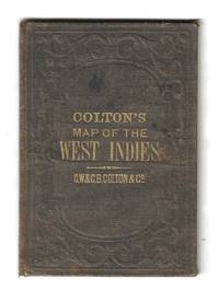
185578137New York: G.W. & C.B. Colton 1855. Hand-colored lithograph map of the Caribbean showing Florida and Central America with insets of Bermuda and the city and harbor of Havana. This example is colored according to national allegiance with British territories in red Spanish in yellow and so on.<br />  <br /> The map is printed on a 17†x 14 ¾†sheet of banknote paper and folds into brown cloth-covered boards with gilt titles. Some light foxing with a few small spots. There is a bit of creasing along the right margin not affecting the image. The boards are rubbed and faded with some light soiling as well. G.W. & C.B. Colton unknown
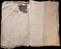
1898List2965United States and Caribbean 1898. Approximately twenty-nine pieces: logbook of eighty-four double-sided pages measuring 13 x 20 inches; eight letters seventeen documents and forms and three pieces of miscellany. Much wear and significant damage to logbook including water damage mildew and tearing; log book overall fair to good minus. Other materials good to very good. Overall good. William Higgins 1791–1872 was a farmer sea captain and owner of and investor in ships from Bowdoinham Maine. According to the Maine Maritime Museum which holds his family papers Higgins’ ships traded mainly in lumber which they took from Wilmington North Carolina to the Caribbean.<br /> <br /> Offered here is a logbook recording the travels of several of Higgins’ ships particularly the brigs Mary Jane and Llewellyn alongside related documents and personal letters. The logbook dating between 1832 and 1836 extensively documents the course wind data and weather remarks for travels of the ships between east coast US port cities and various locations in the Caribbean including Barbados St. Thomas and Martinique. The logbook also contains a copy of astronomer and mathematician Elijah Burritt’s illustration “A Plan of the Solar System Exhibiting its Relative Magnitudes and Distances†engraved by W. G Evans and printed in 1835 by F.J. Huntington.<br /> <br /> The letters and documents date from 1830 to 1867 and are also mostly business-related including an insurance document for the brig William Parrington a roll of sailors enlisted to work on a six-month journey between the Caribbean and the US in 1845 a bill of sale for ¼ stake in the brig Mary Jane and receipts and logs for items including various liquors sugar molasses casks and so on. One letter from a young man in Wilmington requests advice on how to start his own business in the style of Higgins’; other letters concern family matters. One interesting undated document is a writ addressed to the Marshal of the District of Maine concerning a lawsuit filed against Higgins and Rufus Carr master of the William Parrington by Zachrisson Nelson Co. The suit alleged that Carr acting as an agent for the ship’s owners that is Higgins had agreed to an affreightment involving shipping from Jamaica to Spain to New York but had then “wholly neglected and refused to do soâ€.<br /> <br /> Of interest to scholars of maritime history and trade in the mid-19th century. unknown