Puerto RicoABAA
1 résultat
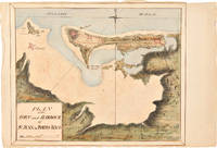
1804WRCAM31595N.p. but probably San Juan 1804. 13 x 9 inches plus two supplementary untitled sketches of the same size. Executed in an exacting hand. Contemporary reds greens blues and browns remain bright and clean. Fine. An attractive Puerto Rican view which shows the town of San Juan its harbor sandbanks islands and fortresses. The plan is marked by a compass rose and rhumb lines. These defenses at San Juan guarded Spanish colonial positions against incursions by the French Dutch and British. The primary plan the only one with its structures labeled runs from Isle de Cabras in the west to Fort St. Antonio in the east. At the center is Moro Castle the six-level masterpiece of Spanish colonial architecture that remains at the heart of present-day San Juan. Construction of the imposing fortress began in 1540 and was completed nearly fifty years later in 1589. Interestingly these plans do not show Fort San Cristobel construction of which began in 1634. Puerto Rico was opened to foreign trade in 1804 and it is possible this plan was composed shortly thereafter to provide either American or British traders with an idea of the island's infrastructure. A wonderful sketch of Puerto Rico's military resources done in brilliant color. Early Puerto Rico material is quite rare. unknown books