7 résultats
1660441AG1660. Amsterdam Blaeu c.1660. Beautifully handcoloured Original Engraving copper engraving with the decorative and pictoresque Cartouches. Beautifully framed. Size of Frame with map: 66.5 cm x 80 cm. Map itself measures: 44 cm x 58 cm. Excellent condition of this beautiful original 18th century map of this area in Denmark. Framed Handcoloured ! Professionally cleaned historical map beautifully and professionally mounted/restored on see-through acid-free paper. Willem Janszoon Blaeu also abbreviated to Willem Jansz. Blaeu was a Dutch cartographer atlas maker and publisher. Blaeu was born at Uitgeest or Alkmaar. As the son of a well-to-do herring salesman he was destined to succeed his father in the trade but his interests lay more in Mathematics and Astronomy. Between 1594 and 1596 as a student of the Danish astronomer Tycho Brahe he qualified as an instrument and globe maker. In 1600 he discovered the second ever variable star now known as P Cygni. Once he returned to Holland he made country maps and world globes and as he possessed his own printing works he was able to regularly produce country maps in an atlas format some of which appeared in the Atlas Novus published in 1635. In 1633 he was appointed map-maker of the East Indian Company. He was also an editor and published works of Willebrord Snell Descartes Adriaan Metius Roemer Visscher Gerhard Johann Vossius Barlaeus Hugo Grotius Vondel and the historian and poet Pieter Corneliszoon Hooft. He died in Amsterdam. He had two sons Johannes and Cornelis Blaeu who continued their father's mapmaking and publishing business after his death in 1638. Prints of the family's works are still sold today. Original maps are rare collector items. The Dutch painter Johannes Vermeer of Delft 1632-1675 holds a position of great honor among map historians. Several of his paintings illustrate maps hanging on walls or globes standing on tables or cabinets. Vermeer painted these cartographical documents with such detail that it is often possible to identify the actual maps. Evidently Vermeer was particularly attached to a Willem Blaeu - Balthasar Florisz van Berckenrode map of Holland and West Friesland as he represented it as a wall decoration in three of his paintings. Though no longer extant the map's existence is known from archival sources and second edition published by Willem Blaeu in 1621 titled "Nova et Accurata Totius Hollandiae Westfriesiaeq. Topographia Descriptore Balthazaro Florentio a Berkenrode Batavo". Vermeer must have had a copy at his disposal or the earlier one published by Van Berckenrode. Around 1658 he showed it as a wall decoration in his painting "Officer and Laughing Girl" which depicts a soldier in a large hat sitting with his back to viewer talking with a smiling girl who holds a glass in her hand. Bright sunlight bathes the girl and the large map on the wall. Vermeer's gift for realism is evidenced by the fact that the wall map mounted on linen and wooden rods is identifiable as Blaeu's 1621 map of Holland and West Friesland. He captures all of its characteristic design decoration and geographic content." His maps formed the bulk of the Atlas Maior that became a collector's item in Amsterdam. One of Blaeu's globes was purchased at auction by Maarten Magielse a Dutch salesman for the record price of 60.000 euro about $80.000. Magielse is now renting it to the globe museum in Vienna where it is being exhibited. Wikipedia unknown
1680200040AG1680. Amsterdam F. de Wit c.1680. Original hand-coloured engraving. Plate Size: 58.1 cm x 48.8 cm. Sheet Size: 63.8 cm x 53 cm. Original map. In very good condition with only the slightest hints of browning to outer margns only. This beautifully engraved chart shows the main Danish islands of Funen and Zealand plus the eastern coastline of the Jutland peninsula and a little of southern Sweden. The major Danish cities like Copenhagen Aarhus and Odense are shown on the map. The map is filled with minute detail of fortresses cities towns and tiny villages. Relief depicted pictorially The lower right corner of the map bears a stunningly decorative cartouche featuring the Danish royal coat-of-arms and a Classical scene of putti and merfolk frolicking in the sea with the god Mercury in the foreground. A small compass rose lies off the Schleswig Holstein coast in the Colberger Heide. Frederick de Wit 1629/1630 1706 was a Dutch cartographer and artist who drew printed and sold maps. By 1648 during the height of the Dutch Golden Age De Wit had moved from Gouda to Amsterdam. As early as 1654 he had opened a printing office and shop under the name "De Drie Crabben" the Three Crabs which was also the name of his house on the Kalverstraat. In 1655 De Wit changed the name of his shop to the "Witte Pascaert" the White Chart. Under this name De Wit and his firm became internationally known. The first cartographic images that De Wit engraved were a plan of Haarlem that has been dated to 1648. The first charts engraved by De Wit were published in 1654 under the "De Drie Crabben" address. The first map that was both engraved and dated by De Wit was that of Denmark: "REGNI DANIÆ Accuratissima delineatio Perfeckte Kaerte van 't CONJNCKRYCK DENEMARCKEN" in 1659. His first world maps "NOVA TOTIUS TERRARUM ORBIS TABULA AUCTORE F. DE WIT" and Nova Totius Terrarum Orbis Tabula appeared around 1660. His Atlas began to appear around 1662 and by 1671 included anywhere from 17 to 151 maps each. In the 1690s he began to use a new title page "Atlas Maior" but continued to use his old title page. His atlas of the Low Countries first published in 1667 was named Nieuw Kaertboeck van de XVII Nederlandse Provinciën and contained 14 to 25 maps. De Wit quickly expanded upon his first small folio atlas which contained mostly maps printed from plates that he had acquired to an atlas with 27 maps engraved by or for him. By 1671 he was publishing a large folio atlas with as many as 100 maps. After Frederick de Wit's death in 1706 his wife Maria continued the business for four years printing and editing De Wit's maps until 1710. However as De Wit's son Franciscus was already a prosperous merchant by this time and had little interest in his father's business he did not take over the publishing house. In 1710 Maria sold the firm at auction. At the auction most of the atlas plates and some of the wall map were sold to Pieter Mortier whose publishing company grew to become one of the largest cartography publishing houses of the 18th century. The 27 chart plates from his 1675 Sea atlas were sold at the 1710 auction to the Amsterdam print seller Luis Renard who published them under his own name in 1715 and then sold them to Rennier and Joshua Ottens who continued to publish them until the mid-1700s. Wikipedia unknown
165051209Frederick de Wit 1650. Contemporary Coloring. With Wonderful Cartouche Upper Right. 1 vols. 23 x 20 inches. About Fine. Framed and glazed. Contemporary Coloring. With Wonderful Cartouche Upper Right. 1 vols. 23 x 20 inches. Frederick de Wit unknown
168942652London William Berry 1689. Ca 58x88 cm. Frame and under plexiglass. Large engraved map of Denmark in contemp.outline colouring. Perhaps the largest engraved map of Denmark from the 17th century. <br/><br/><em>Berry is sometimes called the English Sanson as he copied Sanson's maps and his followers Jaillot Seller and Senex. This scarce map is a copy of Jaillot's map from 1674 in spite of the printed information "Described by Sanson corrected and amended by William Berry." The large map shows "Schonen Blecking Halland Dukedom of Sleswick and the Diocess of Holstein." - Bramsen p. 11 cartouschen a. p. 120. </em> unknown
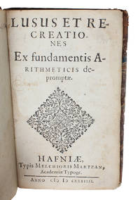
163456014Hafniæ Copenhagen Melchior Martzan 1634. Lille 8vo. Lidt senere hldrbd. Let rygforgyldning. Rester af titeletiket. Ryg lidt slidt. 4542 pp. 1 kobberstukket planche. De første blade løse. Mangler blad A8 Pp. 11-12. <br/><br/><em>Originaludgaven af en af de allerførste lærebøger udgivet i Danmark vedrørende læren om de hele tal og regnearterne i matematikken. Bogen var tiltænkt som lærebog i elementær aritmetik for de studerende på Christian den IV's Akademi i Sorø og indøvelsen skete ved hjælp af en række opgaver som stilles i bogen. Lauremberg 1590-1658 var både mathematiker filolog og digter. Han blev af Chr. IV indkaldt til professoratet i matematik ved det adelige Akademi i Sorø hvor han forlod sin stilling i Rostock som det Filosofiske Fakultets dekan. I Sorø virkede han som professor i matematik og ingeniørvidenskab fra 1623 til sin død i 1658. Han var en ikke ubetydelig matematiker og foregangsmand særlig kendt er han for sin indførelse af logaritmerne i Danmark. Det er oså velkendt at Chr. IV havde udset Lauremberg til at udføre det første danske kartografiske værk ved opmåling af landet. Hans virksomhed som korttegner var allerede begyndt i Mecklenburg og det ses at han i en del år var optaget af denne virksomhed i Danmark. Kortværket blev imidlertid aldrig til noget til kongens store fortrydelse. Herefter overtog Johannes Meyer kortlægningen. Lauremberg er yderligere kendt som en af tidens mest fremragende latinske poeter således indeholder hans "Satyra" fra 1636 spirene til de senere plattyske "Skjæmtedigte".The very scarce first edition of one of the first elementary textbooks in arithmetics published in Denmark. The work should be used teaching mathematcs at the University in Sorø founded by the king Chr. IV in 1623.Bibl. Danica II18. - Niels Nielsen. Matematikken i Danmark 1528-1800 p. 127 No. 3. </em> unknown
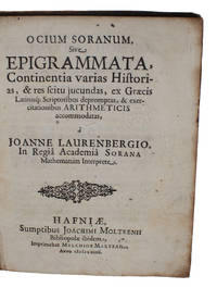
164048600Hafniae Joachim Moltken 1640. 4to. Contemp. full calf. Gil t spine. Wear to top of spine. Blindtooled lineborder on covers. Some wear to spine corners and along edges. Engraved bookmark on inside frontcover "North Library. 1860". 81111 pp. and 1 engraved plate with 6 illustrations. A bit of browning to one quire. A few annotations in a contemporary hand. Otherwise internally clean. <br/><br/><em>Originaludgaven af en af de allerførste lærebøger udgivet i Danmark vedrørende læren om de hele tal i mathematikken. Bogen var tiltænkt som lærebog i aritmetik for de studerende på Christian den IV's Akademi i Sorø. Bogen er på latin og indeholder 61 opgaver som han indpakker - for at være pædagogisk og fastholde studenternes interesse - i latinske hexametre med historisk mytologisk og anekdotisk indhold. De her indeholdte historier giver L. anledning til at fremsætte opgaver som studenterne skulle løse aritmetisk. I forordet fortæller han selv at han har bestræbt sig på at gøre sin matematik smagelig for den adelige ungdom ved praktiske opgaver og ved anekdoterLauremberg 1590-1658 var både mathematiker filolog og digter. Han blev af Chr. IV indkaldt til professoratet i matematik ved det adelige Akademi i Sorø hvor han forlod sin stilling i Rostock som det Filosofiske Fakultets dekan. I Sorø virkede han som professor i matematik og ingeniørvidenskab fra 1623 til sin død i 1658. Han var en ikke ubetydelig matematiker og foregangsmand særlig kendt er han for sin indførelse af logaritmerne i Danmark. Det er oså velkendt at Chr. IV havde udset Lauremberg til at udføre det første danske kartografiske værk ved opmåling af landet. Hans virksomhed som korttegner var allerede begyndt i Mecklenburg og det ses at han i en del år var optaget af denne virksomhed i Danmark. Kortværket blev imidlertid aldrig til noget til kongens store fortrydelse. Herefter overtog Johannes Meyer kortlægningen. Lauremberg er yderligere kendt som en af tidens mest fremragende latinske poeter således indeholder hans "Satyra" fra 1636 spirene til de senere plattyske "Skjæmtedigte".The very scarce first edition of one of the first textbooks in number theory published in Denmark The work should be used teaching mathematcs at the University in Sorø founded by the king Chr. IV in 1623. In 61 cases using latin epigrams of historical and mythological content he proposed 61 mathematical problems to be solved thus introducing pedagogical means in the teaching of mathemtics in Denmark.Bibl. Danica Supplement spalte 195. - Niels Nielsen. Matematikken i Danmark 1528-1800 p. 127 No. 5. </em> unknown
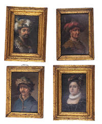
1700L1ABDB3KUTB6Denmark 1700. Collection of four paintings oil on paper or paperboard two measuring 8 x 5.5 cm frame 10.5 x 7.5 cm and two measuring 8.5 x 5.5 cm frame 10 x 7 cm all with a gilt wooden frame. Two sets of two miniature paintings the individual sets painted in matching style and set in matching frames with the two slightly larger frames painted to match the two smaller ones.Ad 1: Portrait of a 16th-century woman possibly Anne of Denmark 1532-1585 wearing a red feathered cap with her hair decorated with pearls a pearl earring a small pleated ruff and a low-necked black bodice with pearls.Ad 2: Portrait of a man with a drooping moustache in oriental costume. He wears a white turban decorated with a rooster a pearl earring and a gown with a large fur collar. The collar is set with gemstones on which hang insignia's of a crescent moon with the points down above three stars.Ad 3: Portrait of a 17th-century man wearing a broad-brimmed hat with a red feather a pearl earring and a leopard fur collar.Ad 4: Portrait of a man with a thick moustache wearing a pearl earring and a blue hat and oriental coat lined with lynx fur. Provenance: Manor House in Jutland. With an inscription at the back of ad 1 "Claude George Gew Anne 1738" and wax seals on the backs of ads 1 2 and 3. Ad 4 with a 19th-century ticket "95". The top layer of ad 3 slightly damaged at the top right revealing part of the red underpainting; otherwise an interesting set in good condition. ABE CAT Costumes & Uniforms unknown