(Balkan Nationalism)Biblio.com
2 résultats
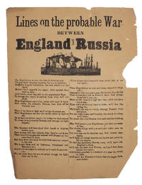
18785190s.l.: s.n. 1878. Small broadside 185 x 250mm woodcut vignette below title text in two columns. Poor-quality paper chipped and somewhat toned a few tears touching title larger area of loss to one margin clear of text. A scarce and fragile broadside of patriotic doggerel to inspire Englishmen to ‘arrise sic with heart and hand And sweep the cowardly Russian bear from off the Turkish land.’ With reference to Crimean war battles at ‘Inkerman Sebastopool and Balaclava too’ it likely dates from the Russo-Turkish war of 1877-78 when British warships were sent through the Dardanelles to aid the city of Constantinople although the signing of the Treaty of San Stefano on March 3rd 1878 ended the conflict and obviated the cause for this ‘probable war’. Poorly-printed with numerous compositing errors on thin paper this is an unlikely survivor and we have not been able to trace any copies in any collections. Although last line present ends with a comma it seems a fitting finish so this is likely another typo rather than an indication of more text on another sheet. [s.n.] unknown
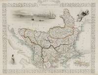
1851200055AG1851. London and New York J & F. Tallis 1851. Original steel engraving / Vintage map. Drawn and engraved by John Rapkin. Partly hand-coloured. Illustrations by H. Warren and engraved by J. Rogers. Plate Size: 32.5 cm x 26 cm. Sheet Size : 37.4 cm x 27.3 cm. Vintage 19th century map in very good condition. Published in the Illustrated Atlas And Modern History Of The World Geographical Political Commercial & Statistical Edited By R. Montgomery Martin. Beautiful and interesting map of South East Europe. Much of the Balkans was then under the control of the Ottoman Turks. The region is delineated into the historic - and future - nations and states including Croatia Herzegovina Bosnia Serbia Albania Macedonia northern Greece Bulgaria Walachia in Romania and Moldova. Russia can be seen extending down into the areas around the Black Sea. Hapsburg-Austria and the heel of the Italian peninsula is shown. Corfu Cyprus and the Greek islands can be seen lying of the archipelago. Gallipoli Sea of Marmara the Bosporus and Constantinople/Istanbul and Asia Minor/Anatolia are shown in the lower right corner. John Tallis 7 November 1817 3 June 1876 was an English cartographic publisher. His company John Tallis and Company published views maps and atlases in London from roughly 1838 to 1851. Tallis set up as a publisher with Frederick Tallis in Cripplegate in 1842; the business moved to Smithfield in 1846 and was dissolved in 1849. From 1851 to 1854 Tallis operated as John Tallis and Company. He started The illustrated news of the world and national portrait gallery of eminent personages in 1858 selling it for £1370 in 1861; it folded in 1863. Wikipedia The most important project John Tallis undertook was the 'Illustrated Atlas' from 1851. The original map we offer here was part of this exceptional Atlas and all the maps it contained are still today considered as the last reminder of an era of lavish map production. Tallis worked the project together with John Rapkin 1815-1876 and it was Rapkin's style and talent that we have to thank for when we marvel at these maps today. What makes these maps so special is the detail of engraved vignettes that surround the map and often show indigenous scenes people in their environment and even more so historical buildings or historical views of towns and cities architecture and landscape. The project of 'The Illustrated Atlas' was designed to be finished just in time for the anxiously awaited "Great Exhibition of the Works of Industry of All Nations" or The Great Exhibition sometimes referred to as the Crystal Palace Exhibition in reference to the temporary structure in which it was held was an international exhibition that took place in Hyde Park London from 1 May to 11 October 1851. It was the first in a series of World's Fairs exhibitions of culture and industry that became popular in the 19th century and it was a much-anticipated event. The Great Exhibition was organized by Henry Cole and Prince Albert husband of the reigning monarch Queen Victoria. It was attended by numerous notable figures of the time including Charles Darwin Samuel Colt members of the Orléanist Royal Family and the writers Charlotte Brontë Charles Dickens Lewis Carroll George Eliot and Alfred Tennyson. Music for the opening was under the direction of Sir George Thomas Smart and the continuous music from the exhibited organs for the Queen's procession was "under the superintendence of William Sterndale Bennett". Wikipedia unknown