[ATLAS 1576]. PORCACCHI, ThomasoBiblio.com
2 résultats
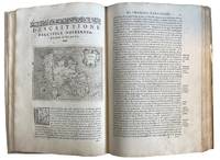
157643595Venice: Calignani & Porro 1576. Foliated 29.7 x 20.9cm a large complete untrimmed copy The enlarged Second Edition small folio 29.8 x 20.2cm 24201.1 colophon foliated with 47 copper plate maps decorated initial letters head and tail pieces in later full vellum red leather label gilt titles title page is lightly sprinkled with tiny spots a very good to fine large complete untrimmed copy of this enlarged edition containing 17 additional maps not in the first edition of 1752. fine. ~ ~ ~ ~ <br /> Header:. Porcacch. The Most Famous Islands Of The World. 1576. <br /> <br /> ~ ~ ~ Shirley. The Mapping of the World 127; The World Encompassed 87; Phillips. Atlases I67; European Americana 576/35; Sabin 64149; JCB I 263-264; Adams P-1905. This is one of the most beautiful works of its kind produced in the 16th century and is the ï¬rst to have maps engraved on copper rather than on woodblocks. "The popularity of Bordone's Isolario brought forth a successor which from both the cartographical and topographical point of view was far more distinguished. Porcacchi's description of the "most famous islands of the world" included the areas represented in the other atlas and devoted the third book to islands of the New World of the Pacific and the Indian Ocean. " "The ï¬rst world map is a ï¬nely-executed reduction of Camocio's large world map of 1567 one of the last in the long line of derivatives from Gastaldis prototype of 1546. The illustrated tract on islands presented here is said to be Porcacchi's most important work. - <br /> <br /> ~ ~ ~ Most of the maps included are: Iceland Hebridean islands and Orkney Gotland Hibernia Ireland England Scotland Sealand Maiorica Menorica Spain Malta Venice Italian archipelago corfu Curzolari Ionia Kefalonia island in the Ionian Sea Zante Morea Cerigo Candi of Indonesia Scarpanto Rhodi Santorini Milo Nixsia Cyrus Metellino Constantinople Stalimene Aegean Negroponte Greece Ciprus Temistitan Mondo Nuouo Spagnola Cuba San Lorenzo Peru S.Giovanni deL isole Molucche Indonesia and Del Mappamondo. The word Atlas was first used in the first collection of maps by Gerardys Mercator's "Atlas sive cosmographicae. 1585-1595 Calignani & Porro unknown
157418848Venetia Venice Giordano Ziletti 1574-73. 4to. Hcalf from ab 1820. Gilt back. Slight rubbing to spine. 78350 pp. and 65 double-page engraved maps with text on verso of plates 130 pp5665 pp. 6 textlvs. at end with brownspots in right margin sometimes a little browning to pages few brownspots and a few textlvs. with minor wormtracts. Complete with all 65 maps called for each measuring ab. 19 x 26 cm. A great part of the maps have some background shadowing from the printers ink mainly due to the fact that this is the third Ruscelli-edition where the plates have been used before. 3 printer's wood-cut devices and 20 smaller and larger woodcuts in the text. 2 woodcuts with Ptolemy shown observing. <br/><br/><em>Third edition of Ruscelli's translation from Venice 1561. The maps are printed from the same plates with the exception of Ptolemy's map of the world for which Malomba had returned to the original conical projection of Ptolemy. Moreover one map is added: the map of "Territorio di Roma". In general the maps are enlarged copies of Gastaldi's maps from the edition of 1548 which came out in 8vo. The Ruscelli translation contains an important innovation namely the division of the world map into two parts one for the Old World and one for the New as seen on the plate "Tavola Universal" depicting the 2 hemispheres. The atlas contains 27 ptolemaic maps and 38 new. 1 World 1 Hemisphere 10 Europe 4 Africa 12 Asia and 38 others. 10 of the maps relate to America.Philipps I:380. Sabin 66505. Nordenskiöld Nr. 34 p.27. </em> unknown
