1 résultat
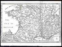
1748372039Printed for T. Osborne in Gray's Inn; A. Miller in the Strand; and J. Osborn in Paternoster Row London 1748. Unframed Print. Very Good Condition. This 1748 map provides a detailed representation of Roman Gaul covering regions such as Narbonne Lyon and Aquitaine. It was engraved by Emanuel Bowen a renowned cartographer of the time known for his intricate and highly detailed maps. The engraving was printed in London by T. Osborne A. Miller and J. Osborn.1 folding plate. Close cropped at the left margin. Untidily folded at right side. Size: 20 x 30 cms. Category: Universal History; PRINTS : Antiquarian Interest; Printed before 1800; Special Features. This item may require more postage than the rates shown for delivery outside the UK. If extra postage is required we will contact you before processing your order and you will be given the details and option to decline the extra cost. Printed for T. Osborne, in Gray's Inn; A. Miller, in the Strand; and J. Osborn, in Paternoster Row unknown