34 résultats
197661240Flagstaff: Northland Press 1976. Hardcover. x 212p.11.5x9.75 inches landscape layout personal inscription signed by Briggs on endpaper paintings charts foreword bibliography index lightly-used and soiled first edition stated in white cloth boards and price-clipped worn dj with closed tears. Northland Press hardcover books
193115471931. SOCONY OIL COMPANY NEWSPAPER 1931. TOURS AND DETOURS. An original August 15 1931 edition of "Tours and Detours"- a tourism-related newspaper issued by the Socony Oil Company to its customers. This issue contains articles about touring the Northeast region of the United States with photographs and articles on Clinton NY; Buffalo & Niagara Falls NY; and Plymouth Rock in Massachusetts. The rear cover contains a road map of main highways in New England. Following the break-up of Standard Oil in 1911 the Standard Oil Company of New York SOCONY was formed along with 33 other break-off companies. In 1920 the company registered the name "Mobiloil" as its trademark and in 1963 it became the Mobil Oil Company. Very Good usual folds with a few tears. Scarce 10.00. <br/><br/> unknown books
194113424New York: Harcourt Brace & Co 1941. First Edition. Octavo 21cm. Cloth boards; dustjacket; 570p. A few small spots to backstrip; mild rubbing to bottom edges of boards else Near Fine. In original dustjacket unclipped but with light overall rubbing and a brief ca 3/4" closed tear to upper margin of rear panel. A very good copy overall. A novel of the Texas oil industry. Somewhat uncommon especially in jacket; this a solid and attractive copy. Harcourt, Brace & Co unknown books
1921802Colusa Ca. 1921. About very good. 8pp. Pictorial self wrappers stapled. Light wear and creasing; a few short closed tears at wrapper edges. Contemporary ownership inscription on front wrap. Even tanning. A scarce promotional for the Young Oil Company and its development of an apparently lucrative oil strike at Bear Creek in Colusa County during 1921. The pamphlet prints a story first published in the local Colusa Sun newspaper which documents history of oil production at the site chronicles the purchase of the lease by Young Oil in 1915 and relates positive comments from several contemporary geologists' reports that convinced the company to significantly increase its investment and work on the property including the imminent arrival of an industrial drilling rig from Texas. The remainder of the text publishes a letter from a Sacramento oil man William Babcock which describes the operation as "The best oil venture that I know of -- in fact it looks so good to me that while I have for all intents and purposes retired from active participation in the development of the oil business I shall in this case make an exception." The final leaf prints an enjoinder from the company to "Buy all the Young Oil Company stock you can afford" and gives the organizational information of the firm. Illustrated with five halftone images of the site; not in OCLC. unknown books
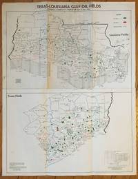
195096Houston 1950. Very good. Map 22 x 17 inches. Folded. Light wear and soiling. Map of the Louisiana and southern Texas oil fields along the Gulf of Mexico. Each county is outlined with oil fields noted in green and gas fields noted in red. unknown books
1939213762San Francisco: State of California Department of Natural Resources Division of Oil and Gas 1939. 46p. 6x9 inches preface reports tables maps graphs and cross-sections several folding very good first edition annual in stapled yellow pictorial wraps. Special articles on Canal and Strand Oil Fields Arvin Area of Mountain View Oil Field and Premier Area of Poso Creek Field. State of California Department of Natural Resources Division of Oil and Gas unknown books
196537968Louisville KY: Standard Oil 1965. Hardcover. Very good/No jacket issued. Louisville KY: Standard Oil 1965. Copious b/w illustrations. Various pagination pp. Hardcover. 8vo size. Medium green cloth. Bound periodical for the year 1965. Head heel and corners bumped and rubbed; moderate soil to boards. Very good/No jacket issued. Standard Oil hardcover books
196437964Louisville KY: Standard Oil 1964. Hardcover. Very good/No jacket issued. Louisville KY: Standard Oil 1964. Copious b/w illustrations. Various pagination pp. Hardcover. 8vo size. Forest green cloth. Bound periodical for the year 1964. Head heel and corners bumped and rubbed. Very good/No jacket issued. Standard Oil hardcover books
196238063Louisville KY: Standard Oil Company 1962. Hardcover. Very good/No jacket issued. Louisville KY: Standard Oil Company 1962. Numerous b/w photographs and illustrations. Various pagination pp. Hardcover. Small 4to size. Brown cloth. Gilt lettering to front board. Bound edition for the year 1963; head and heel slightly rubbed; slight insect damage to top of front board. Very good/No jacket issued. Standard Oil Company hardcover books
1986149439Budapest: ICPS 1986. 38p. 8x5.5 inch wraps booklet faintest signs of age or handling. ICPS H-1415 / Documents on the struggle against chemical weapons volume II. ICPS unknown books
194029695New York: Standard Oil Company 1940. First Edition. Octavo 22.25cm.; original tan printed card wrappers; 4170pp. Minor wear else Very Good or better. Standard Oil Company unknown books
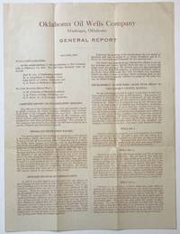
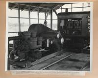
1918664Muskogee Ok 1918. Very good. 4pp. on a large bifolium. Previously folded. A couple of very minor losses at fold points. Light tanning. Scarce illustrated report from 1918 on the developments and production of the Oklahoma Oil Wells Company based in Muskogee Oklahoma. Much of the text is dedicated to an assessment of work completed on wells located at lease secured by the company near Sedan in Chautauqua County Kansas to which the majority of available funds was being directed. The progress of four wells is assessed and a report on construction and acquisition of other equipment necessary for the site is given. The production of other leases in Nowata and Muskogee Counties Oklahoma and Greenwood County Kansas is also discussed. The final page contains three photographic illustrations of a power plant and a well on the Sedan property as well as a lengthy exhortation to invest in Liberty Bonds to support the federal government's war effort as World War I continued through 1918. Also with a separate typed letter dated January 9 1917 soliciting investment from an Ohio resident. unknown books
192315067Boston 1923. 8vo pp. 210 little water stained on the foredge affecting the last few leaves a very good copy bound in red cloth. This trade catalogue contains advertisements of and descriptions of a wide variety of hoses and pumps and gaskets as well as hand tools grease guns pipe fitting tools wrenches brushes rulers and files. unknown books
1943540Venezuela 1943. Very good. 48 original photographs each 8 x 10 inches. Quarto. Plain leather boards twin-bolt binding. Some photos detached from mounts some wear to covers but images generally fine with typed captions affixed beneath each photo. A rare photographic document of Venezuelan oil production in the early 20th century. This album contains nearly fifty large-format original images that depict the construction of a 157-mile crude oil pipeline from Las Mercedes Del Llano Guanico to a deep-sea terminal at Pamatacual in 1943 by the Sociedad Anonima Petrolera las Mercedes owned jointly by the Texas Company later Texaco and British-controlled Caracas Petroleum S. A. Venezuelan oil reserves attracted foreign investment as early as 1908: "In 1908 General Juan Vicente Gomez took power to become the strongest dictator of the 20th century with 27 years in office. He opened the gate to foreign oil investors.World War I was the trigger introducing Venezuela into the world oil market. After 1919 the investment and the exportation of Venezuelan oil increased tremendously. By 1922 Venezuela became an important supplier of oil in the world and biggest reserves of oil were discovered in the Lake of Maracaibo. During World War II Venezuela was the most secure provider of oil to the United States." -- Johannes Alvarez and James Fiorito Venezuelan Oil Unifying Latin-America. Venezuela increased its production 42 percent in 1943 and 1944 to satisfy the Allied demand for wartime oil. The images contained in the present album show various features of the pipeline oil wells and storage facilities at the inland stations as well as the path of the pipeline through the jungle to the sea. Several photos depict groups of men at work on the line in several locations. Another series of images depict views of the terminal station and the construction of its structures as well as its shipping facilities and the operations surrounding the loading of tankers there. From a research perspective this album is a fascinating look into the development of the now-critical oil industry in a lesser known region of mid-20th century Venezuela the involvement of American in this case Texan companies in South American industrial growth as well as the importance of South American resources to the United States war effort during World War II. We were unable to find any examples of large format photographs from the Venezuelan oil industry from this period in auction records or on the market. Photographs of Venezuelan oil production from outside of the Lake Maracaibo region where the bulk of early oil development occurred are equally difficult to locate. The printed title page suggests that more than one of these albums was produced but we are unable to uncover another example in OCLC or archived sales records. unknown books
199420537NY: Watson-Guptill. Fine in Fine dust jacket. 1994. Hardcover. 0823032736 . 335 color illustrations. First printing. Fine in a fine dust jacket. . Watson-Guptill hardcover books
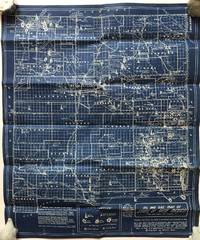
19361182Los Angeles: Brooks Bros 1936. Very good plus. Blueprint map 21.5 x 18.25 inches. Old fold lines minor wear. A few pencil annotations. An interesting and quite attractive blueprint map that shows the oil and gas fields of New Mexico where oil was first discovered in 1924. The map was compiled and drawn by Fabius and Sam Brooks Los Angeles publishers and was based on a 1931 map by Dean Winchester and "corrected to date" likely in the mid-1930s. The map shows the locations of oil and gas fields across the state and delineates sites of oil drilling their proprietors and the depths at which they hit oil or gas. Also included are the routes of major gas and oil pipelines. At the lower left corner of the map is a list of principal lease holders in New Mexico broken into tiers by acreage with Standard Oil holding over a million acres and the next group holding 100000 to 500000 each down to 5000 individuals and small companies who hold anywhere from 40 to 5000 acres. We locate a handful of copies of the Winchester map and one copy of a later dated Brooks map with a different title but none of the present issue. A highly attractive and informative New Mexico oil map. Brooks Bros unknown books
1927910Whiting In 1927. About very good. 119 leaves printed on rectos only; interleaved with fifteen additional leaves containing pasted brochures and ephemera. Small folio. Original half cloth and boards brad-bound; one brad lacking. Cloth worn hinges tender. Light soiling and wear to contents. Wonderful mimeographed handbook produced for and distributed to bulk station operators of Standard Oil of Indiana a subdivision of the original Standard Oil trust. Standard Oil of Indiana covered a broad territory ranging across Indiana Illinois Michigan Wisconsin Minnesota the Dakotas Iowa Kansas and Missouri. The first three leaves draw the reader in: "Stop! Look! Read! / YOU can make more money / This book show YOU how. Let's you and I read it over very carefully and see how it can help us." There follows a page discussing "What is a Salesman" and a discussion of the products Standard offers and why they're the best. Each page is printed with illustrations and a small amount of text -- easy to comprehend like a children's book and certainly designed to be used in one's sales pitch. Bulk station operators were charged with maintaining large storage tanks of gasoline or oil distributing large shipments of product to farmers and other small-scale businesses across the Midwest. This particular book belonged to agent Alf Anderson of Viroqua Wisconsin a remote village on the eastern end of the state near the borders with Iowa and Minnesota. In addition to Standard's iconic brands of fuel and motor oil such as Red Crown and Vis operators like Anderson were also charged with marketing a wide array of additional products made by Standard many of which are advertised in the brochures pasted to the additional leaves within this volume. These include Eureka Harness Oil Eureka Belt Dressing Cream Separator Lubricant Mica Axle Grease Neolite Burning Oil Perfection Kerosene KIP Insecticide and more. A mimeo production chock full of sales tactics and tips for the enterprising agent with the promise of success as reward for careful study. Rare with unique components. unknown books
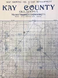
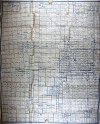
19351420Wichita: Wichita Mapping & Engineering Co 1935. Very good. Large blueline map 40.75 x 47 inches. Rolled. Some excess blue ink along bottom edge. Light wear at edges. Minor toning and dust soiling. Scattered neat contemporary manuscript annotations. Imposing and detailed oil and gas map showing developments in Kay County Oklahoma bordering Kansas directly south of Wichita. The present map delineates all the oil and gas wells being planned and drilled and all wells actively producing and abandoned. These are several large concentrations of activity the largest being between the towns of Blackwell Braman Dilworth and Peckham northeast of the Chikaskia River with others located near Tonkawa Ponca City and between Newkirk and Kaw. The map also notes land ownership for every section of every township in the county."The oil and gas industry stimulated an economic boom in the early 1900s. As early as 1894 gas had been discovered on the Marcus McClaskey farm southeast of Newkirk. However he kept the discovery a secret until he could prove up his land claim. By 1902 approximately six gas wells had been drilled northeast of Blackwell. In 1910 Ernest W. Marland founder of the 101 Ranch Oil Company drilled seven gas wells on the Millers' 101 Ranch. However the great oil boom in Kay County was precipitated by the discovery of oil by Marland on the Ponca allotment of Willie Cries Crys-for-War in June 1911. Louis H. Wentz soon entered the foray to locate oil in Kay County. The oil boom and bust created temporary peaks in population and several ghost towns such as Mervine Dilworth and Three Sands" - Encyclopedia of Oklahoma History and Culture.Not in OCLC. We locate records for four other maps produced by the Wichita Mapping & Engineering Co. with only one being noted in any appreciable amount of copies. Wichita Mapping & Engineering Co unknown books
1922303664Bakersfield California Kern County Chamber of Commerce 1922. 1922. 6 panel folding brochure. Illustrated with 10 halftones and one map. Very good. No signatures or bookplates. Includes information on oil and gas wells farming irrigation gold and silver. Rocq 2431 - located only 1 copy. No Binding. Very Good. Bakersfield, California, Kern County Chamber of Commerce [1922]. unknown books
1985343241985. Softcover. VG-- soiling to cover. White wraps. Unpaginated. Numerous bw and color plates. unknown books
1917291406Self-published 1917. Jamsetji Tata is considered an architect of modern India; he founded TATA -- an enormous Indian business. During the first World War B.J. Padshah one of the Board of Directors of Tata Sons met on board a ship the author of this exhaustive report Edward Thompson. Thompson produced this report urging Tata to get heavily invested in the Copra industry at a time when American investors were investing heavily in copra in the Philippines. Copra proved to a less than immediately successful investement for Tata though Thompson grew rich cf. R. M. Lala The Creation of Wealth: the Tats from the 19th to the 21st Century Chapter 6. ~An uncommon report how could it be otherwise relating to Tatas the most inportant company in India. 179 pp. quarto. Rebacked. Self-published unknown books
19301996Fort Worth: Oil City Map Co 1930. Very good. Large blue line map 34.25 x 27.5 inches. Folded. Scattered contemporary pencil annotations. Minor wear and a couple of short separations along fold lines. Small cut into neat line near upper right corner. Rare and detailed oil map of the oil fields in Shackelford and Callahan Counties just east of Abilene Texas. The map indicates the locations of well being drilled those producing gas wells dry holes and abandoned wells. The owners of the mineral rights are named and well as many of the surface owners which include various railroads and also the Lunatic Asylum. Deaf & Dumb Asylum Bayland Orphan Asylum and other institutions. A large number of the producing wells both oil and gas were owned by Texas Company Texaco the Magnolia Petroleum Co. but many major and small oil companies had obtained mineral rights on lands in the area when this map was produced. The area around the town of Moran as indicated by the number of wells in the vicinity was one of the major sites of oil production in Texas during the 1920s and was indicative of the spread of the oil business to the western and southern portions of the state during that decade. The publishers of this map the Oil City Map Company of Fort Worth were not particularly prolific -- we locate six examples of their other cartographic work all recorded in single institutional copies and no copies of the present map. Oil City Map Co unknown books
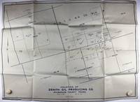
19291995Wichita Falls Tx: Montgomery & Ward 1929. Very good plus. Large blue line map approximately 22 x 29 inches. Folded. Very light tanning and a few small spots of soiling. Scattered contemporary pencil annotations. Unrecorded map showing the extent of mineral rights held in a section of Wilbarger County Texas by the Zenith Oil Producing Company and several competing interests. The county is located in North Texas on the border with Oklahoma west of the oil rich areas surrounding Wichita Falls and Burkburnett. Indeed the land here was mapped by a civil engineering firm from Wichita Falls Montgomery & Ward certainly not to be confused with the famed mail order and department store business. The Zenith Oil Producing Company for whom this map was created owned mineral rights in seven contiguous plots in the charted region but seems to have been active only for a short period of time at the end of the 1920s and solely in the area of Wichita Falls. We locate no other copies of the present map and only one other recorded example of a map by the Montgomery & Ward firm a 1931 plan of Wichita Falls. Montgomery & Ward unknown books
19091289Oakland 1909. About very good. Six pieces including three real photo postcards typed letter folding map and transmittal envelope. Light creasing to images; light tanning to letter and map. Interesting promotional material for the La Blanc Oil Company for their developments in the Sunset Oil Field in Kern County California in 1909. A folding plat map of the field near Maricopa southwest of Bakersfield shows La Blanc's holdings highlighted in red and a brief text touts the geographical relation to other producing wells. Also included is a typed progress report on the depth of drilling accomplished and the anticipated time before reaching the deposits which assures investors that "No doubt is expressed by any one of our ultimate success." The photo postcards show supposedly representative images of gushing oil pipes overflowing oil barrels and a very pleased group of men overseeing the scene. A nice group with the original transmittal envelope addressed to an Edgar Bonnemort of Oakland. unknown books
194172764Washington: GPO 1941. Paperback. Good. 382p. No separate wrapper. 24cm. First leaf creased at corner and has a few small chips Backstrip browned. "Printed for the use of the Special Committee." Also included is a folded copy of the separate brief five-page Preliminary Report by the Committee issued on September 11th 77th Congress. 1st Sessions. Senate Report No. 676. <br/><br/> GPO paperback books