491 résultats
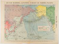
1942180751Chicago.: Chicago Daily Tribune. Friday June 51942. Printed colour map on a single newspaper leaf 37.5 x 53.2 cm; 44.7 x 59.8 cm sheet inset legend marginal browning and at the folds some undulation of paper and tide mark along lower section but in remarkably bright very good condition. Strategic map published in the Chicago Daily Tribune "The World's Greatest Newspaper" on June 5th 1942 two days after the Japanese attack on Dutch Harbor the site of the US army and navy bases in the Aleutians and as it transpired at the outset of the Battle of MIdway. The owner and proprietor of the Tribune Robert McCormick was staunchly against the United States entering the war and had firm views once it had occurred that American resources should not be used defending the British Empire. Famously the Tribune published the "Victory Program" Roosevelt’s military plan to prepare the United States for possible entry into World War II and was subject to prosecution for an alleged violation of the Espionage Act relating to the newspaper’s front-page account of the Battle of Midway 4-7 June 1942. It became an important test case for the limits of free speech and censorship during war-time. <br> <br>The Legend shows territorial Control of Ocean Areas marking Japanese Naval and Air bases as of 1941 and "according to latest reports" those established in the first six months of 1942. Also shown are pre-war sovereignties as at the bombing of Pearl Harbour on December 7th 1941. The Anson Archipelago is shown but a question mark "indicates islands etc. whose existence or give position is doubtful…". . Chicago Daily Tribune. unknown
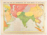
1942180782Chicago.: Chicago Daily Tribune. April 211942. Printed colour map on a single newspaper leaf 37.5 x 53.2 cm; 60 x 45 x 59.6 cm sheet marginal browning and at the folds but remarkably bright in very good condition. World War II map of Asia save for Japan showing British allies colonies and lines of supply and marking Japanese territorial occupation published in the Chicago Daily Tribune "The World's Greatest Newspaper" in April 1942. <br>"The Indian Ocean and the Bay of Bengal are the strategic waters in this campaign in which the occupied parts of Burma and the Andaman Islands serve as bases" caption <br>". the historic Chicago Tribune was an innovator in color inks and printing but also a pioneer in bringing colorful art in the form of illustrations photographs cartoons and advertisements to the average person in an everyday medium." see The Janet A. Ginsburg Chicago Tribune Collection Michigan State University Libraries. . Chicago Daily Tribune. unknown
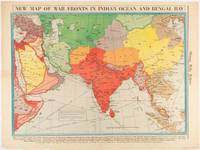
1942180760Chicago.: Chicago Daily Tribune. January 91942. Printed colour map on a single newspaper leaf 37.2 x 53.4 cm; 45 x 59.9 cm sheet inset legend marginal browning and at the folds lower margin with small edges tears not affecting the caption but remarkably bright in very good condition. Rare map of Asia "Between Suez on the west and Shanghai on the east" showing territorial interests and theatres of war published in the Chicago Daily Tribune in January 1942 barely two months after the Uniited States had joined the war effort after the bombing of Pearl Harbour. Thailand and Vietnam "French Indo-China" are marked "Occupied by the Japanese" and north-eastern China similarly marked Iran "Anglo-Russian Occupation" and the Gulf states "British Ally". The caption notes that "The map inludes waters thru which runs the British life line from the Suez canal to remote Australia and New Zealand. Nearly half the people in the world live in the lands shown on this map--more than 450 million for example in China and more than 375 million in India". <br> <br>". the historic Chicago Tribune was an innovator in color inks and printing but also a pioneer in bringing colorful art in the form of illustrations photographs cartoons and advertisements to the average person in an everyday medium." see The Janet A. Ginsburg Chicago Tribune Collection Michigan State University Libraries. . Chicago Daily Tribune. unknown
1941180789Chicago.: Chicago Daily Tribune. December 121941. Printed colour map on a single newspaper leaf 41.5 x 53 cm; 45.1 x 59.9 cm sheet three inset maps of the Japanese Empire; Taiwan and Ryukyu Islands; and Hokkaido and Chisima marginal browning and at the central fold but remarkably bright in very good condition. Map of the Japanese Empire ominously titled published in the Chicago Daily Tribune one week after the bombing of Pearl Harbour. Prefectures are attractively coloured. <br> <br>Based on a Rand McNally map the Tribune briskly got to work issuing maps for readers showing the beginnings of the war with Japan. Later maps were also published for sale separately but remarkably few have survived. <br>". the historic Chicago Tribune was an innovator in color inks and printing but also a pioneer in bringing colorful art in the form of illustrations photographs cartoons and advertisements to the average person in an everyday medium." see The Janet A. Ginsburg Chicago Tribune Collection Michigan State University Libraries. . Chicago Daily Tribune. unknown
1981ABE-1695424354339Ross-Erikson Inc. 1981 Cloth 8vo. 1st edition. 239 pp. Red boards with gilt at spine. Illustrated DJ. Translated by Henry Munn. Scarce hardcover edition. 1st Edition. Hardcover. Near Fine/Near Fine. Ross-Erikson Inc. hardcover
192625.0469Buenos Aires : Sociedad de Publicaciones El Inca 1926. 1ª ed. Rústica. 14x18.5. Sociedad de Publicaciones El Inca paperback
198517861<p>November 1 1985; Limited edition #767/1000; signed by artist. Text in Spanish/Espanol. Near Fine HC in Very Good slipcase. Dark green cloth over boards gilt stamped titles on front cover and spine; illustrated end papers; 57 full page color plates recto with short text verso. Bright clean square covers and spine; tightly bound; bright clean interior; 2 of the color plates have small area 3/4 inch and 1/2 inch of partial paper lift where plate adhered to facing text page; corresponding color on the 2 text pages; colophon gives print information and run indicating 1000 thus this being No 767 and 39 more limited copies; artist full signature in black ink below print statement. Slip case is covered in matching green cloth with full page color illustration on paper panel with titles in black at upper half; unprinted off-white paper panel on rear face; green silk ribbon attached interior to facilitate volume removal from slipcase. Slipcase is square and sound; bright clean on front illustrated face and on edges; rear panel is scuffed lightly soiled. Oblong 4to unpaged 57 plates with facing text; short text prologue. Cf OCLC #15409009.</p> Sabadell: Editorial AUSA hardcover
19292110502150304495Daiichishobo 1929. Soft Cover. Fine. Volume: 1 Daiichishobo paperback
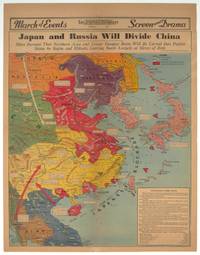
1940209821Los Angeles.: Los Angeles Examiner. 1940. Printed colour pictorial map on a single newspaper leaf 42.3 x 39.9 cms; 54.3 x 42.5 cms sheet archivally laid down on linen slight discoloration to lower centrefold and sheet slightly age-toned but in very good condition. A striking geopolitical map by Los Angeles Examiner artist Howard Burke covering China Japan Southern Russia and the northern part of French Indochina and Siam showing how the "Aggressors Divide China." Areas under Japanese occupation are shown in red and their naval blockade shown by an arc of naval vessels with vivid arrows indicating lines of supply. Text labels including sources of agricultural and raw materials provide a dynamic overview of the geopolitical situation and show the influence of American scientific illustrator and cartographer Richard Edes Harrison who argued for examining geographic issues from multiple perspectives and Los Angeles Times artist Charles Owens. . Los Angeles Examiner. unknown
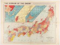
1945208877Chicago.: Chicago Daily Tribune. August1945. Printed colour pictorial map on a single newspaper leaf 37 x 52 cms; 43 x 59.5 cms sheet three inset maps archivally laid down on linen very good condition. Full page map published in the "Chicago Daily Tribune" after the bombing of Hiroshima and Nagasaki prior to occupation by US and Allied forces in September 1945. "This is a new map of the main islands of Japan where American occupational troops will land and establish their military rule." map text The legend notes "Places bombed by U.S. Air Forces with a red circle" and "Cities bombed by Atomic Bomb" with a red star. The main map shows the Japanese islands of Honshu Shikoku and Kyushu with the Korean peninsula. Inset maps show Hokkaido Formosa and a general map of the area. . Chicago Daily Tribune. unknown
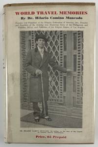
193212800Washington DC: Claude T. Clements Press 1932. 14362pp. Profusely illustrated. Publisher's tan cloth with titles stamped in brown on spine and front board. In original unclipped pictorial dust jacket. Minor edge wear light insect damage to boards. Dust jacket either trimmed a bit short or originally produced a half-inch shorter than boards. Minor dust-soiling to jacket with minor insect damage to rear flap. Internally clean. Overall very good. The rare autobiographical travel narrative by one of the most important Filipino-American political leaders in history especially notable for retaining the original pictorial dust jacket. Hilario Camino Moncado established the Filipino Federation of America in 1925 in Los Angeles California. It was also known at various times as the Filipino World Federation and the Filipino Crusaders World Army. As one of the fraternal organizations appealing to the small but growing Filipino immigrant community the FFA distinguished itself from competitors by accentuating "clean living" and rules of moral conduct. Moncado earned a law degree and also edited and published Filipino Nation. Through his work Moncado sought to portray the immigrant community as responsible and healthy in contrast to the then-prevalent depictions of them as uneducated gamblers. Much less publicly the FFA developed a set of religious teachings that held Moncado to be the reincarnation of Jesus Christ by way of José Rizal the Filipino patriot executed in the waning days of Spanish rule. Moncado's birthday was changed to make him appear to have been born after Rizal's death so that his identity as Rizal's reincarnation would be more plausible.<br /> <br /> In the present travel memoir Moncado focuses on political and social issues encountered on a trip around the world conveying an impression of worldliness which burnished his reputation within the Filipino-American community. He visits England Holland Germany France Italy Egypt India China Japan and "Home Sweet Home Philippines." A sampling of chapters focus on London his visit to Oxford University the refusal of Germany to pay reparations from the First World War mentioning the German people's and particularly Hitler's stance against paying them any further his visit to the League of Nations "Mussolini - Benevolent Despot or Tyrant" Gandhi and "India's Revolution" China "The Awakening Giant" "Americanized Japan" and the betrayal of the Filipino independence movement by the American Congress.<br /> <br /> OCLC records just eight institutional copies including one in the Philippines one in Singapore and six in the United States at NYPL UC-Davis the University of Hawaii Michigan Washington and Wisconsin. Claude T. Clements Press unknown
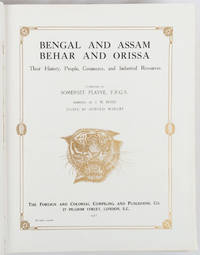
1917214418London and New York.: The Foreign and Colonial Compiling and Publishing Co. 1917. Numerous black and white photographic illustrations. 768pp. Full red morocco binding spine lettered and ruled in gilt in compartments 'Tiger head' emblematical device stamped in gilt on the upper board repeated in gilt on the title page corner ornaments blocked in gilt. All edges gilt marbled endpapers light rubbing to corners but a lavishly produced edition in exceptional condition. 30 x 23.5cm One of a series of publications published with the object of supplying the British public with a picture - complete as far as literary and pictorial effort could make it - of the several different parts of the Empire. in this instance Northern India. . The Foreign and Colonial Compiling and Publishing Co. unknown
2000mon0000679700Covenant Books 3/12/2021 12:00:00 A. hardcover. Very Good. 0.3150 in x 10.3150 in x 8.3071 in. Crease on cover Covenant Books hardcover
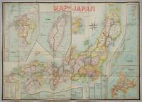
1906197908Kobe Japan.: Fuku-In-Kwan. 1906. Printed colour folding map on two conjoined sheets laid down 73.8 x 10⁵ cms foxing on verso not affecting map single pinhole in each corner scant spotting small fold splits no loss a few soft fold creases but in good condition. Very rare striking map of Japan published for the Western market. <br> <br>Created under the direction of Takachika Okishio featuring 10 inset maps: Chishima Kurile Islands Hokushu Hokkaido Ogasawara-Jima Bonin Islands Hachijo-Shima Ioshima Okinawa Saki-Shima Kyushu Saikaido Taiwan Formosa and Eastern Asia. The insets of Taiwan and Kyushu are the largest and centrally positioned. A Glossary and Explanation of Signs is printed at the foot of the map which list Towns Railway Stations Boundaries of Prefectures Notable Places Hot Springs Water-falls rapids Volcanoes Light-Houses Gold Silver and Coal-Oil fields. The Japanese Government Railway series of Travellers' Maps of Japan appear to have been modelled after this design. . Fuku-In-Kwan. unknown
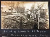
191353568Hornell NY & Low Moor VA: Homer A. Sitterley Asst. City Engineer for Hornell NY; Chief Mining Engineer Low Moor Iron Co. 1913-1917. Oblong 8vo. 10 x 7 in. 142 pp unpaginated. thick black paper stock w/ 298 original photographs sized from 2 x 3 in. up to 3.25 x 5.5 inches 280 this size 2 of them cyanotype and the majority with neat white ink manuscript descriptions linen-backed frontisp. map of Hornell NY dated 1915. Contemporary limp black-cloth post-binder sewn at gutter margin w/ black silk braid minor soiling tidemark to outer fore-edges of front cover first couple leaves minor fraying & wear to corners still a VG- exemplar w/ most images with strong contrast. This remarkable album documents the tremendous range of road building projects sewer improvements bridge building and dam construction in and around Hornell NY in Steuben County in the years before World War I. Steuben County was the next to the last County in New York State to join the Good Roads Board sponsored by the American Automobile Association in 1907 primarily because during the opening decades of the 20th century that area of New York had some of the worst roads. These images show the construction and building of sewer lines on Crosby Street Canister Street paving projects on East Ave. Jane Street West Street -- with fantastic images of early Foote Concrete Machinery Co. road paver in operation pouring concrete West Genesee Street Church Street and others. Sitterley b. 1889 makes a study of the filtering systems and sewer plant for New York City at the time includes photo of the newly opened Hornell trolley “Subway†as well as numerous photos of poor condition sidewalks which were slated for modernization as an adjunct of the Good Roads agenda hand-in-hand with laying of new sewer lines. In addition he has included photo of himself with surveyor’s transom and the Hornell City Engineer together with the City Park Superintendent. A significant portion of the album is devoted to the building of the Seneca Street Bridge including the building of the coffer dams to hold back the water to pour the piers the construction of the abutments and finally the finished bridge. That bridge would later be rebuilt by a WPA project in 1936 and now is up for replacement again. Sitterley’s last major projects were overseeing the building of the new Hornell city dams and city reservoirs together with road improvements gate houses and spillways. In March 1916 he leaves Hornell NY to become Chief Mining Engineer for the Low Moor Iron Co. which was a producer of pig iron in Alleghany County of Western Virginia which operated from 1872-1930. The company was often plagued with labor unrest as they maintained very poor “Company†towns and were constantly struggling with the Chesapeake & Ohio Railroad to ship their ore. In 1916 they were on the upswing as a company as the growing steel demands of World War I began to lift all ore producers at the time. See: Corning Convention of Good Roads Associations Good Roads Magazine April 1907 pp. 134-135; Homer Aldrich Sitterley Bi-Monthly Bulletin of the American Institute of Mining Engineers No. 126 June 1917 p. xxxv; Russell Story of the Great Flood and Cyclone Disasters in New York State 1913 New York Roots 1999; Papers of the Low Moor Iron Company 1873-1927 Special Collections Univ. of Virginia Library 2010. Homer A. Sitterley, Asst. City Engineer for Hornell, NY; Chief Mining Engineer, Low Moor Iron Co., hardcover
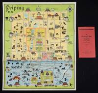
1934158433Peiping.: Peiyang Press. circa1934. Coloured folding plan of Peking with original envelope. 60 x 50cm. A few neat repairs at folds two panels evenly browned on reverse. A very good copy of a scarce pictorial plan with its envelope. This delightful and scarce pictorial map of Peking with landmarks and streets in romanised Chinese with occasional Chinese characters is surprisingly scarce. Although apparently issued in several editions in the 1920s and 30s it appears relatively infrequently on the market. The divisions of the Legation District are indicated by their flags - this edition shows the German Legation by use of the black white and red bands of the German flag. This flag which was no longer used after 1935 helps date this edition. Other landmarks and attractions shown included theatres foreign shopping area adjacent to the legations quarter Liu Li Chang Curio District the racecourse the many city gates etc. . Peiyang Press. unknown