Ortelius, AbrahamBiblio.com

3 résultats
1587016842: Abraham Ortelius Original 1587 But This A Reprint 1587. 5th or later Edition . No Binding. Near Fine/No Jacket. 19" x 17. Image Size: 18 7/8" X 13 3/4". Text "Cum Privilegio Decennali Ab. Ortelius Delineab. Et Excudeb. 1587" At Lower Right. However This Must Be A Late Eighteenth Century To Twentieth Century Reprint Printed On Wove Paper Sheet Never Placed In An Atlas. Strong Impression And Color Minor Loss Of A Millimeter Depth In A Tiny Area Of Lower Left Margin Otherwise Undamaged. Margins Irregular Up To 1" Deep. Professionally Cleaned And De-Acidified With Archival Materials By A Museum-Experienced Conservator. <br/> <br/> Abraham Ortelius (Original 1587 But This A Reprint) unknown
1526137339Florence: Impressum per hæredes Philippi Iuntae 1526. Classical geography in the renaissance An early edition of this collection of classical geographical texts including Pomponius Mela and Julius Solinus and a translation into Latin of the Greek 1st-century world geography of Dinoysius Periegetes. The text is based on the first edition of the collection printed by the Aldine press in 1518. Octavo 149 x 96 mm. Eighteenth-century vellum spine lettered in gilt marbled sides. Vellum a little wormed rear hinge reinforced sporadic light foxing and a few instances of minor soiling faint dampstain at foot of ff. 17-24 and to top right corner of ff. 185-193 and 208 minor pencilled marginalia throughout cropped early annotations to ff. 51r 52r 68r and 204r and a few other early inked lines minor paper fault to f. 135v. A very good copy. hardcover
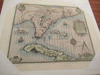
1592026339Frankfurt am Main 1591 1592. Original Antique Map . Single Sheet. Near Fine. Laid Paper. Size: Image And Border Approximately 17 7/8 Inches X 1M.5 Inches 45.2 Cm X 36.75 Cm. Debry Printed His Voyage To Virginia In 1590 As Part I Of His Works But Burden Mapping Of North America Provides No Record That A 1592 Printing Exists. This Map Has No Center Fold But Contemporary Engravings Exist Of The Offices Of The Great 17Th Century Cartographic Publishers With Row Upon Row Of Flat Drawers For Storage Of Single Maps; It Would Be Unreasonable To Believe That None Of These Unbound Maps Survived. This Appears To Be One Of Them Although The Consensus Of Modern Dealers Is That No Unfolded Large Map First Published In A Book Can Exist. Although We Have Been Unable To Locate A 1592 German Edition Of Debry We Believe This Is A Map As Issued In The 1592 German Edition Of De Bry Which Was First Published In 1591 And Subsequently Reprinted In 1592 And 1594 And In The Seventeenth Century. Small Cartouche At Lower Left Monogram With Text "Caesavece Matis. Privilegio Mdxcii" In The Plate Added After Original 1591 Printing. This Is An Unfolded Sheet Which Was Never Bound In A Book; A Strong Impression Without Damage And With Old Light Partial Coloring. Once Quite Aged Then Professionally Cleaned De-Acidified And Mounted Loosely With Archival Materials By A Museum-Experienced Conservator In About 2000. Scarce. And Now 430 Years Later It's Depicting A Hangout For Orangutans. <br/> <br/> unknown