FER Nicolas deABAA
6 résultats
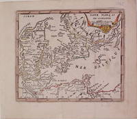
1725204942Paris: de Fer Nicolas 1725. unbound. very good. Map. Engraving with modern hand coloring. Image measures 5.25" x 6.25".<br/><br/> Charming miniature map of Denmark with the Coat of Arms incorporated in the cartouche. Map includes both Schleswig and Holstein while today part of the former and all of the latter are northern Germany. Nicolas de Fer 1646-1720 was a French cartographer engraver and publisher. He became official geographer to the French Dauphin 1691 and to the Spanish King 1702.<br/><br/> de Fer, Nicolas unknown books
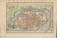
1715019811Paris. Very Good. 1715. Map. Lovely engraved map depicting Mexico City in the early 18th century. Map is on a 10 ¾" x 15 ¾" sheet that was taken from Nicolas de Fer's "L'Atlas Curieux" of 1715; no content on verso. Date of map was printed in upper margin along with the sheet number "125" and title; content in French. Hand-coloring is still bright. Map has very light toning to edges but is otherwise clean. This detailed map depicts Mexico City when it was surrounded by water and was linked to the mainland by the famous causeways originally designed by the Aztecs. Also pictured are aqueducts and farms and about 50 locations have been numbered on the map but the key is not present likely printed on another page in the Atlas. A beautiful map. . unknown books
17026200Paris: Chez l'Auteur 1702. First printing. Map folio sheet 12.75"x9" 23x33cm. Copperplate engraving. Significant early map of this area locating the mouth of the Mississippi correctly as taken from the information reported by M. La Salle. The right edge includes all of Florida and most of Cuba; the left cuts off most of Baja California. Santa Fe New Mexico is shown at the top the bottom cuts off at the Isthmus of Panama. Attractive cartouche showing two Indians in full regalia. Hand-colored probably contemporaneously. Fine copy. <br/><br/> Chez l'Auteur unknown books
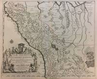
1719291534Paris 1719. Map. Engraving with original hand outline color. Image measures 19 x 23". Sheet measures 20 x 28".<br/><br/> Unusual map of Peru from the early 18th century. Includes part of Ecuador Bolivia and Brazil based on Jesuit activity in the area. Amazon rain forest is visualized with a dynamic design. Cartouche describes the mining industry. Nicolas de Fer 1646-1720 was a prolific cartographer engraver and publisher who took over the family map business from his mother when she retired in 1687. The business flourished and he gained a great reputation in his lifetime and was appointed 'Geographer to the King' in 1690. This map demonstrates his skill and provides a curious yet alluring mixture of history and geography.<br/><br/> unknown books
170123030Paris: Nicolas De Fer 1701. First Edition. Very Good. Ginville Vincent de. Ginville Vincent de. First Edition. Paper size 42.5 cm x 28.5 cm. Plate mark 34 x 22.5 cm. Marked "sculpsit Vincent de Ginville" lower left. Paper clip mark just to the plate mark upper margin '109' inked upper right corner some marginal chipping to the paper marginal old pencil price lower right. A few unobtrusive spots inside the plate marks. Copperplate engraving with later hand color. From Nicolas De Fer's Atlas Curieux. Highlights locations of Indian villages found by La Salle during his explorations of the coastal areas of the United States. LOC online We see the Gulf of Mexico Cap de la Floride and many inland village names. A nice map showing some early history of the southern United States. Nicolas De Fer unknown books
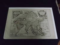
1722biblio10<p>Engraved double page map 28" x 20" wide margins hand colored in outline two uncolored pictorial cartouches. Expert and nearly invisible repairs along centerfold normal aging; about near fine. Impression is bright and clean. Nicholas De Fer 1646-1720 was a highly respected and prolific French cartographer whose maps were valued for their decorative appeal. Around 1690 he was made the geographer to the Dauphin and published his first atlas. He would become geographer to other high-ranking individuals in French and Spanish society. The present map is detailed and attractive map of Asia with a cartouche showing Chinese at the upper left and Indians in the upper right. The map covers a lot of territory showing Arabia and the Persian Empire in the West and Japan in the east but goes as far south as the Isle of Borneo and Java. Part of Eastern Europe is also visible. Library missouri website.</p> books