12th Armored Division AssociationBiblio.com
28 résultats
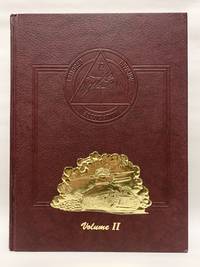
199050180Paducah KY: Turner Publishing 1990. First Edition. Hardcover. Near fine. 248p quarto. Volume 2 only. A near fine copy lower corner bumped lower edge of back board has a small scuff/tear else fine. <br/><br/> Turner Publishing hardcover
194575299Germany: Second Armored Division. Very Good. 1945. Original Vintage Map. 29 x 42 inch original vintage map produced by the U.S. Military titled "Hell on Wheels War Against the Axis 1942-1943-1944-1945" detailing the route and battles of the 2nd Armored Division as they worked their way from France through Belgium and into Germany in World War II. This is the larger version of a map which was issued the previous year. The map shows general handling wear and some edge chipping. There is a small mostly closed tear in the lower left quadrant. Included with the map is the original heavy mailing tube which shows it was sent by a Private Anderson APO New York to his family in Quinnimont Fayette County West Virginia. The map appears to be scarce in the trade with only 1 original currently listed for sale online vialibri. An example is listed and shown at David Rumsey's map website. We are offering this vintage World War II map with its original mailing tube. OCLC offers this note: "Shows route of 2nd Armored Division from Littry France to Gutergluck Germany with historical notes for selected locations. Includes brief history of the 2nd Armored Division. Marginal information includes place names military insignia and names of military divisions. Passed for press duplication by A.E.F. Field Press Censor." . Second Armored Division unknown
19458673Germany: G-2 Section 2nd Armored 1945. First version of a campaign map charting the wartime progress of the US 2nd Armored Division sheet size 58.5 x 75 cm printed in colours blank verso. The lower panel deals with operations in North Africa and Sicily with the units insignia flanked by key placenames; the main map covers the Normandy invasion through to the Battle of the Bulge. The border of tank tracks incorporates the Allied invasion star painted on vehicles for swift recognition and the names of the units commanding officers including blood and guts Patton. The maps creator M.E.B. remans unidentified. This version of the map is not listed on Worldcat but the revised edition is and Worldcat suggests that the author is Mary E Gellie; she was certainly published under the initials M.E.B. but these are mostly improving tales for younger readers written in the 1870s and 1880s. As the map was published by the G-2 or intelligence section of the unit the artist may have been on the staff. The map was probably published in the field: this edition was passed by censor and the revised edition advises that it has been passed by the Allied Expeditionary Force censor suggesting that they were printed near to where the unit was located. As noted on the map the unit entered Germany in September 1944 although the last action mentioned on the map was fought in eastern Belgium as Allied forces rushed to contain the German Ardennes offensive. The final date is December 23-28 1944 when 2nd Armored was involved in the destruction of the 2nd Panzer Division in the Celles pocket. The first date given on the revised map is 16 January 1945 when elements of 2nd Armored completed the encirclement of German forces in the Ardennes at Houffalize and it seems reasonable to assume that our map was drawn in the first weeks of January. Map G-2 Section, 2nd Armored unknown