EDO TO NAGASAKI TRADE ROUTESBiblio.com

1 115 résultats
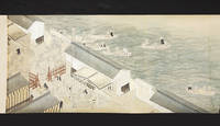
10960Scroll 385 x 8560 mm. with fine colored paintings using brush ink & various colors of wash of the route and major features along the way. Japan: mid-Edo.<br /> <BR> <BR> The route from Edo today’s Tokyo to Nagasaki and vice versa by land and by sea was one of the major thoroughfares and trade routes of Edo-period Japan. The Dutch and Chinese had been allowed to establish exclusive trading outposts in Nagasaki and Edo was the heart of domestic commerce and administration. Foreign goods especially silks other luxury items raw materials useful to the military and medicinal goods flowed through Nagasaki to Edo and the rest of Japan while Japanese goods including copper silver and porcelain were transported to Nagasaki for export. Most of the silver was sent to China to settle the trade balance. From the late 1670s to the 1740s Japan was the world’s largest copper producer and exporter. This route also carried the head of Nagasaki’s Dejima trading post to Edo for frequent mandatory ceremonial audiences with the shogun.<br /> <BR> <BR> The beginning of our scroll depicts the land route from Edo to Kyoto and then on to Osaka. The famous battleship Atake Maru is seen docked at the mouth of the Sumida River. Starting from Edo Castle in the great capital the scroll proceeds to Nagoya and Kyoto along the TÅkaidÅ road which was the most important highway of the Edo period. It depicts in great detail and with manuscript labels: stations on the route; bridges; major castles temples and shrines; the palace at Kyoto; other notable buildings; important geographical features including Mount Fuji partly shrouded in clouds; and towns and villages along the way.<br /> <BR> <BR> Distances are given and travellers are well-depicted showing their various clothing. Also shown are ships and skiffs in the nearby sea.<br /> <BR> <BR> We see more landmarks along the TÅkaidÅ road from Kyoto to the commercial hub and port city of Osaka an extension built in the 1620s. Arriving at Osaka we view the great castle the city’s canals and other sites.<br /> <BR> <BR> The rest of the scroll shows the hazardous passage from Osaka to Nagasaki through the 400 km. long Inland Sea Seto Naikai. The accomplished artist depicts the two main routes and alternate routes depending on the weather one for summertime in the open sea and the other hugging the coast for wintertime. Another route is shown that involved landing in the Bungo area of KyÅ«shÅ« island and crossing overland to Nagasaki. Navigating through the Inland Sea with its 3000 plus islands and rocky outcroppings presented enormous problems in the era before modern navigation systems. Shown in very great detail are areas of turbulence including famous whirlpools numerous islands rock formations landscapes for orientation anchorages harbors along the way and fishing areas. The route then passes through the narrow Kanmon Strait the stretch of water separating the main island of Honshu and KyÅ«shÅ« to the Sea of Japan finally arriving in Nagasaki. Dejima is prominently shown. A foreign ship is shown passing the GotÅ islands making its way to Nagasaki.<br /> <BR> <BR> Our scroll is finely drawn in black ink and heightened with wash in green blue gray pink and red. The routes are drawn from a partial “bird’s-eye†perspective with lovely vistas of mountains and islands and villages and towns.<br /> <BR> <BR> In fine condition preserved in an oldish wooden box which has the inscription on the outside of the lid 江戸長崎海陸é“ä¸çµµå›³ “From Edo to Nagasaki Travel by Land and by Sea Illustratedâ€. Inside this lid is the ownership inscription of RyÅra Gakuto. unknown
19732080402107100635Not Available 1973. Soft Cover. Fine. The book is in fine condition. Not Available paperback
In -8°, pp. 109, (b), cartonato, tagli rossi. Prima edizione. Francesco Pasio (1551-1612) fu il primo provinciale gesuita in Giappone, residente a Nagasaki; il libro comprende anche una lettera del vice-provinciale Pedro Gomez (1533-1600), autore del “Compendium”, ovvero un trattato di cosmologia e teologia che sarebbe diventata la prima opera a introdurre la cultura occidentale in Giappone; segue un testo di Nicolò Longobardi (1559-1654), gesuita siciliano che in Cina fu il successore di Matteo Ricci (nominato varie volte in questo testo); la quarta e ultima lettera è un resoconto di una missione presso i territori islamici del Mogol (India, Pakistan, Afghanistan). Marca dei gesuiti al frontespizio e capilettera figurati. First edition. Pasio (1551-1612) was the first Jesuit Provincial in Japan: he resided in Nagasaki; the book includes also a letter of his deputy Pedro Gomez (1533-1600), author of the “Compendium”, a cosmology and theology treaty that had to become the first work to introduce western knowledge in Japan; then a text by Nicolò Longoboardi (1559-1654), a sicilian jesuit who replace, in China, Matteo Ricci (mentioned many times in this text); the fourth and last letter is the chronicle of a mission in Islamic areas of Mughal (India, Pakistan, Afghanistan). A Jesuit mark on title page and figurative initials. Pasio (1551-1612) was the first Jesuit Provincial in Japan: he resided in Nagasaki; the book includes also a letter of his deputy Pedro Gomez (1533-1600), author of the “Compendium”, a cosmology and theology treaty that had to become the first work to introduce western knowledge in Japan; then a text by Nicolò Longoboardi (1559-1654), a sicilian jesuit who replace, in China, Matteo Ricci (mentioned many times in this text); the fourth and last letter is the chronicle of a mission in Islamic areas of Mughal (India, Pakistan, Afghanistan). A Jesuit mark on title page and figurative initials.
19862080302106808310Yoshikawakobunkan 1986. Soft Cover. Fine. Number of books: 8 Yoshikawakobunkan paperback
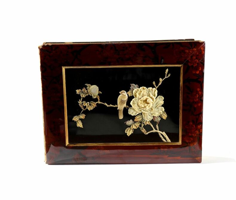
1890AMO-4520[Japon, Yokohama ?, vers 1890] Très beau spécimen en grand format (36 x 27 cm environ pour l'album et 26,5 x 20,5 cm pour les tirages). Complet. Très bel album très bien conservé malgré quelques chocs sur quelques bords et le dos de l'album manquant (bande de cuir), parfaitement solide et très décoratif. Très belle esthétique d'ensemble, superbe décor sur le premier plat (rare aussi beau et fin). Intérieur d'une grande fraîcheur. Beau coloris au pinceau à la main.
19862080302106809437Edited by the Nagasaki History Editorial Committee Yoshikawa Kobunkan 1986. Soft Cover. Fine. Size: A5 Number of books: 8 Edited by the Nagasaki History Editorial Committee, Yoshikawa Kobunkan paperback
18732080502106917714Not Available 1873. Soft Cover. Fine. The book is in fine condition. Not Available paperback
18021728101802. NAGASAKI. Hizen Nagasaki-zu. Woodcut map of Nagasaki. Coloured woodcut map with outer wrappers the front illustrated. 620 x 860 mm folded in a new chitsu case. Nagasaki: n.p. 1802. A masterpiece of the woodblock printer's art. This splendid and boldly coloured map of Nagasaki includes a distance chart and a table of navigable routes to Nagasaki. The map also depicts the lively maritime life in the Nagasaki harbour. The map also depicts the island of Dejima the only place in which foreign traders were allowed to conduct business with Japan during the Edo period. Extremely rare with OCLC listing only the copies at Princeton LC and Stanford in the U.S. unknown
5736Japan: late Edo. Until the late 17th century the Chinese had been permitted to move in Japan quite freely for trading purposes. But in 1689 due to the rise of smuggling activities the Chinese were restricted like the Dutch to a compound on the eastern tip of Nagasaki - called the "Tojin yashiki" "Chinamen's mansions" - surrounded by a moat and walls with gates which could be locked from the outside. Inside were housed on average 2000 Chinese merchants and sailors along with interpreters inspectors and staff. This scroll depicts two large Chinese ships just off Nagasaki surrounded by a number of smaller transport and supply ships. It is clear that these smaller ships are Japanese based on the clothes the crewmen are wearing. The numerous Japanese government officials are dressed in black robes; they are inspecting the arriving goods sugar raw silk and finished fabrics along with antiques. The final section of the scroll depicts a portion of Tojin yashiki. We see the arriving transport ships warehouses government workers inspecting the arriving goods laborers carrying goods etc. This scroll - based on a scroll at the City Museum of Kobe entitled "Nagasaki tokan koeki zukan" - is unfinished in several ways: it has not been fully colored and it is clearly incomplete at the end. Nevertheless this is a marvelous record of the early trading days in Japan with the outside world. Minor worming carefully repaired otherwise in fine condition. hardcover books
In -8°, pp. 77, (B); cartonato, tagli rossi. Prima edizione. Pasio (1551-1612) fu il primo provinciale gesuita in Giappone, residente a Nagasaki. La lettera compendia le attività dei Gesuiti in Giappone a cavallo dei due secoli, descrive le condizioni di vita in diverse città e si impegna nel racconto delle condizioni culturali del Giappone a quel tempo. First edition. Pasio (1551-1612) was the first Jesuit Provincial in Japan: he resided in Nagasaki. This letter outlines the Jesuits’ activities in Japan, between XVI and XVII century, also giving descriptions of the various life conditions in many cities, and more widely of the Japan culture at that time.
19992080402107100146Not Available 1999. Soft Cover. Fine. Number of books: 42 combined books set Not Available paperback
19632080402107100394Not Available 1963. Soft Cover. Fine. Number of books: 12 books set Not Available paperback
19862080302106804710Yoshikawakobunkan 1986. Soft Cover. Fine. Number of books: 8 Yoshikawakobunkan paperback
19632091502135710645Yoshikawakobunkan 1963. Soft Cover. Fine. The book is in fine condition. Yoshikawakobunkan paperback
19812091202133100827Seibundo 1981. Soft Cover. Fine. Number of books: 9 Seibundo paperback
19612080302106809091Nagasaki University School of Medicine 1961. Soft Cover. Fine. Number of books: 2 Nagasaki University School of Medicine paperback
19842092902138900813Kyoto shoin 1984. Soft Cover. Fine. Size: 27cm Kyoto shoin paperback
19802080302106809124Nagasaki Zuihitsu Club 1980. Soft Cover. Fine. Number of books: 12 Nagasaki Zuihitsu Club paperback
19632091502135703701Yoshikawakobunkan 1963. Soft Cover. Fine. The book is in fine condition. Yoshikawakobunkan paperback
99063801Nagasaki ca.1802 Kojudo. Blue decorated printed covers on yellow paper 2 red Hanko seals sheet size: 68.9 x 47 cm. map size: 64.3 x 45.9 cm. very clean solid and crisp copy color woodblock printed an excellent example. R A R E . . . . AN EARLY WOODBLOCK COLOR MAP OF NAGASAKI . . . A "NEWLY CARVED" MAP OF NAGASAKI BAY & DESHIMA . . . DUTCH & CHINESE SHIPPING . THE MAP: This map shows "SHIN SEN" "NEWLY CARVED WOODBLOCK" of Nagasaki Bay and environs with special attention to Deshima & Chinese Islands where the Dutch and Chinese lived isolated and restricted from the mainland. It also shows the details of Nagasaki city a lively foreign trading port. . The map clearly illustrates the two most important islands of Deshima and the Chinese. Each island had a bridge connecting it to the mainland which was guarded by Tokugawa Samurai. Foreigners were forbidden by Japanese law from entering the mainland. . Products such as water & food were brought to the islands as well as a good number of Japanese prostitutes all sanctioned by the Shogun. . The Dutch Factory manager was granted audience with the Shogun in Edo once a year. This annual event was to pay homage to the Shogun. . The procession was conducted by the Samurai as the group walked a very long distance to Edo. In Edo the Dutch representative paid his respects to the Shogun who sat behind a screen. The Dutchman was instructed to speak dance walk and perform. . There is a stunning and famous primary account of this by Dr. Engelbert Kaempfer published in 1827 please inquire with us as we have a copy in stock. . The harbor shows two large Dutch sailing vessel under full sail with the Dutch and several other flags flying in the breeze. A large sea-going Chinese junk in full sail most likely preparing to get under way. There are also two large Japanese junks moored at the shore line. There are numerous other smaller Japanese junk type vessels in the harbor. . At the corners are four Kanji Chinese characters used by Japanese noting North South East and West. With two cartouches inset at the lower left. The first showing a distant chart from Nagasaki to foreign countries. The second gives the distance from Nagasaki to other port cities in Japan. All distances are cited in Japanese Rim miles. At the extreme left of the cartouche is the Japanese colophon. . The map meticulously shows villages various sights shrine & temples the quay streets harbors beaches rivers important Japanese trading houses located on the mainland across from near the Dutch & Chinese residences. Other large Japanese trading company are shown each street and block is named are labeled. . An historically important a very decorative map. Earlier maps of Nagasaki are always difficult to find. All in all a very nice clean example of an early 19th century map of the whole area. . In the colophon it states we translate: "Nagasaki is beautiful flourishing city in a 4 km. square with mountains in the East South North with a good and large port in the West. There are many Dutch & Chinese merchants." . WOODBLOCK PRINTING: This work was printed on two large Deluxe size sheets of Washi hand-made paper joined at the center. This map was printed on extraordinary large size cherry wood blocks all of which was an expensive and extravagant production. The average woodblock print of the time was printed on a standard sheet ca. 23 x 36 cm. . The map was printed in polychrome: pastel shades of blue yellow green with black 'key' block outline. . DATING: The map as usual is undated printed in Nagasaki. . It is certain the First Edition of this map was printed in Kyowa 2nd year 1801 illustrated in Nagayama see below as Nagasaki map no. 147. Our map herein offered is identical to Nagayama's with one exception. In the colophon at the lower left corner the last box at the left shows a different publisher and their details. . SECOND EDITION: Our map is clearly the exact map as illustrated in Nagayama and is therefore a contemporary reprint of the First 1802 edition. Our example was more than likely printed from the same blocks with a subtle modification to the last four lines showing the publisher's name. . By virtue of the Japanese penchant when reprinting the First Editions of books & maps traditionally the first reprint has the Kanji: "Shin" "New" ahead of the title. As in our example the title also uses "Shin Sen Hizen" "New Printed Treasure" meaning the first reprint of this title. It is true in later years the abuse of "Shin" became a standard for any reprint it was not the case in 1802 when "Shin" meant the first reprint. . After this edition several other undated reprints followed none identical with subtle differences variants and with different colophons. Nagasaki was the first published place other editions do not always state publisher's location. . KYOWA 2ND YEAR 1802: According to three references below this map or ones similar are cited in Kurita Beans & Kohan. They all state "undated" but attribute the date to Kyowa 2nd year 1802. of this map were printed in Nagasaki by various publishers. . Our research also found this map listed in a 1977 Japanese book dealer's catalog he speculates the dates at circa: Ansei 1854-1860 to Bunkyu 1861-1863. This may be true for an even later reprint but did not match exactly our example. . THE FRONT COVER: On the left side of the front cover are five Kanji reading: "KO JU DOH HATSU DA" "PUBLISHED BY KO JU DO" with their red Hanko seal or chop. . RARITY: An historically important and decorative map. Early maps of Nagasaki and the Dutch Factory on Deshima Island are always fascinating and RARE. . Color photos are posted to our website. . CONDITION: The map is in its original blue-printed yellow paper covers. The back cover is blank. The front cover is very clean there is a tiny bit of the usual minimal scuffing to the extremities with a bit more at the top margin. The back cover is clean with a minor bit of typical "toning." . The map is fresh and crisp. The has seven folds in all they are very strong without issues. It folds to be 9 x 15 cm. The registry is excellent the colors strong and vivid there is no fading. . There are four tiny mended pin holes at each corner. These appear to have been professionally restored in the distant past. The map is clean and solid. By and large this is an excellent example more than 217 years old ! . REFERENCES: . NAGAYAMA Tokihide.: AN ALBUM OF HISTORICAL MATERIALS CONNECTED WITH FOREIGN INTERCOURSE. Japanese Title: TAIGAI SHIRYOO BIJUTSU TAIKAN map #147. . Kyoto Koten Do Ko Kai.: KOHAN NAGASAKI CHIZU CHO p.25 #12 illustrated. KURITA Mototsugu.: NIHON KOBAN CHIZU SHU SEI: COLLECTION OF OLD JAPANESE MAPS #71 plate text pp.102-103. He describes and illustrates the Anei 7th year 1778 edition. MODY N.H.N. :A COLLECTION OF NAGASAKI COLOUR PRINTS & PAINTINGS: Showing The Influence of Chinese & European Art on that of Japan plate 37 with title: HISHU NAGASAKI ZU Nagasaki Kyowa 2nd year 1802 Bunkindo and p. xvlll. The map is identical the only difference is the colophon which shows an earlier imprint and different publisher's name. He reads the title in a variant of HIZEN as HISHU. He also illustrates another similar map as plate 36 SHINKAN NAGASAKI NO ZU again the colophon differs from our example. BEANS George H.: A LIST OF JAPANESE MAPS OF THE TOKUGAWA ERA a 4 volume set. See List p.31 1802.5 1802.6 1802.7 & 1802.8 both of which are the Kyowa 2nd year 1802 date. NAKAMURA Hiroshi.: MONUMENTA CARTOGRAPHICA JAPONICA. Japanese Title: NIHON KO CHIZU TAISEI: GREAT COLLECTION OF ANCIENT JAPANESE MAPS pp. 218-219 number 109 is a very similar map of HISHU NAGASAKI ZU 1778 more than likely the first example from which many others used as a primary resource. The similarities are exceptionally similar. SOTHEBY'S.: CODE LIANG. THE LIBRARY OF PHILIP ROBINSON. PART II THE CHINESE COLLECTION. Sale of 22 November 1988 p.99 #103 for a similar Nagasaki map of the same period. . Not in: KERLEN H.: CATALOGUE OF PRE-MEIJI JAPANESE BOOKS & MAPS IN PUBLIC COLLECTIONS IN THE NETHERLANDS. visit our website we have some of the above reference books in stock. . . unknown
18802080302106809824Shinmachi Letterpress Factory 1880. Soft Cover. Fine. Number of books: 5 Shinmachi Letterpress Factory paperback
20022080302106809715Nagasaki tribal history research institute 2002. Soft Cover. Fine. Number of books: 44 Nagasaki tribal history research institute paperback
2081002109000958Nagasaki University School of Medicine N.A. Soft Cover. Fine. Number of pages: 2 70 901 68 19 10 30p 12p 13 sheets Size: 22cm Nagasaki University School of Medicine paperback
1928230704052043ybvkJapan, Osaka Mainichi Schimbun / Tokyo Nichinichi shinbun, Showa 3 (1928). 61 of 62, smaller (12: ca. 14 x 9,5 cm), medium-size (34 of 35: ca. 19 x 14,5 / 14,5 x 19 cm) and largesize (15: ca. 20,5 x 26 cm) original vintage photographs in 14 titled brown orig. delivery-envelopes (ca. 30 x 22 cm); each envelope-folder contains a loose sheet with detailed explanations of every photograph.
20122080402107100791Nagasaki-shi 2012. Soft Cover. Fine. Number of books: 4 books in total Nagasaki-shi paperback