Kaspi,AndréLivre Rare Book
60 résultats
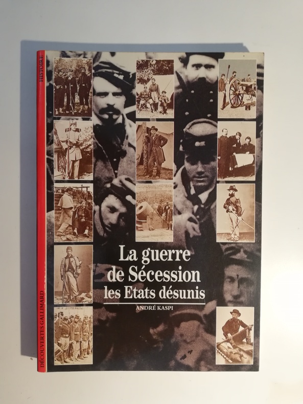
1992SCH216C96GALLIMARD, Paris France, 1992. Petit In-8° Broché de 192pp. largement illustrées avec des photographies, cartes et dessins en N&B et en couleur.
186045008Maine: Rockland Gazette 1860. 1st Edition. A good copy foxed with some chips at the edges and some tears none of which obscure text. One broadside two columns of text. 9-3/8" x 6-3/4" <br/><br/>An extracted leaf from the Rockland Gazette likely printed in early January 1861. The reports include an account of shots being fired on the Steamer of the West supply ship which was en route with supplies to Fort Sumpter. Also recorded is a fight between Senator Robert Tombs 1810-1885 and General Winfield Scott 1786-1866 that began at a dinner party in Washington D.C. and ended with a supposed duel at sunrise with Toombe shooting Scott through the heart. History tells us that Scott died years later at the West Point Hotel after retiring. Fake news! A unique and unrecorded bit of Civil War history. Rockland Gazette unknown books
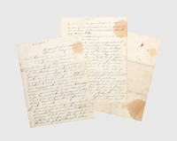
1865190638Charleston: 15 February 1865. It has been determined to evacuate the city of Charleston The military orders sent to the commander of the Confederate garrison in Charleston ordering the evacuation of the city as Sherman's army advanced. Charleston was a symbol of the Confederacy both the birthplace of secession and the site of the war's first shots. The city endured nearly two years under siege by the Union forces suffering heavy shelling from land and water. In February 1865 Union forces seized the South Carolina Rail Road leaving the Northeastern Rail Road as the Confederates' only escape route. On 15 February General Beauregard ordered the city to be evacuated immediately while the rail line remained open. These orders are marked "Confidential" and addressed the same day to Edward Clifford Anderson 1815-1883 who had commanded the post of Charleston since January. They open bluntly: "It has been determined to evacuate the city of Charleston". Thirteen detailed instructions follow including: "I. I desire you to make every preparation for the destruction early Friday night of your guns and gun carriages and such powder as may be left in your magazines as may be consistent with a safe retreat. To attempt to burst your guns or blow up your magazines would perhaps be a premature intimation of our intention to the enemy; therefore you will destroy the gun carriages as far as practicable by sawing and cutting them to pieces; your guns by spiking and shotting them and your powder by throwing it into the water". "IV. On the day of Friday you will cause all the small boats along the wharves to be destroyed by staving them". "V. You will cause the Ashley river bridge to be burned just before the time our troops leave town and you will take steps to provide yourself with combustibles beforehand for that purpose." "VII. When you move you will require your troops to march compactly commanding officers of companies in rear of their companies and permit no soldier to break ranks for any purpose without permission of the commanding officer of his company. Direct the officers to enforce this if necessary by shooting the offender". The evacuation proved chaotic. Jefferson Davis tried to postpone the order but was overruled. Cotton stores were burned and soon after Confederate troops departed the fires reached unexploded munitions causing a devastating explosion at the Northeastern Rail Road depot that killed about 150 people. Union forces entered the city on 18 February and Mayor Charles Macbeth surrendered Charleston to their control and protection. The Official Records vol. XLVII p. 1195 show orders sent the same day from General William B. Taliaferro to Brigadier General S. Elliott conveying similar instructions higher in the chain of command. Comparable orders may have been sent to several commanders in and around Charleston; however we have located no other copy. 3 sheets of lined paper 239 x 181 mm handwritten on 4 pages the final sheet has docketed title final page blank. Splits along old folds with minor repairs staining and foxing: in good condition given its wartime history. unknown
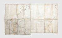
18611848021861-63. The Royal Navy visits the warring North and South Made aboard HMS Rinaldo the map charts its two-year voyage in which it visited the capitals of both sides during the Civil War and transported Confederate emissaries while surviving two serious weather incidents. The accomplished map shows the wide-ranging route of the ship and includes drawings of the early Confederate flag the "Stars and Bars". Rinaldo was a Camelion-class wooden screw sloop launched in 1860 and in operation until 1884. It was commanded by William Nathan Wrighte Hewett who won a Victoria Cross during the Crimean War. The ship sailed from Spithead on 2 June 1861 but as noted on the map "sprang a leak" 400 miles offshore and returned to Plymouth on 18 June. It set off again in July and arrived at Halifax Nova Scotia following a stop in Madeira. It then travelled on to New York. In December it went to Cape Cod to collect the Confederate emissaries John Slidell and James Murray Mason. Slidell and Mason had been forcibly removed from the British steamer Trent causing a diplomatic incident - the Trent Affair - between Britain and the Union government which came close to war. It then set off to Halifax where they could be transported back to Britain. However harsh conditions off the coast of Newfoundland ensured the ship instead travelled to Bermuda. After it failed to arrive at Halifax newspapers reported the ship was feared lost; some Union newspapers celebrated Slidell and Mason's likely demise. The passage on the map shows this abrupt detour. The ship arrived safely in Bermuda in late January 1862 where the emissaries switched to the La Plata for the voyage to Britain. From Bermuda Rinaldo travels along the Confederate coast visiting Charleston Mobile New Orleans and Galveston. The map maker has drawn the Union flag over New York and the early Confederate flag over Charleston Mobile and Galveston featuring the stars in the upper left and red and white bars across prior to the better-known flag used from 1863 onwards. For New Orleans he has drawn the flag of Louisiana in use from 1861 to 1865. While in New Orleans Commander Hewett succeeded in pressing General Butler to recognize the appointed British consul. Leaving America the Rinaldo travelled to Havana and then several stops across Mexico the West Indies and South America returning to Bermuda along the way. In March 1863 Hewett was relieved of his command and returned home. The chart is unfinished ending abruptly mid-Atlantic. Minutes of latitude and longitude are marked on the map. The Bahama Banks are shown in a pale wash marking a serious hazard to shipping and suggesting the sailor knew these waters well. Manuscript on waxed linen 752 x 431 mm. Slight soiling creased where folded. In very good condition. Regis A. Courtemanche No Need of Glory: the British Navy in American Waters 1860-1864 1977 covers the voyage in detail. unknown
Oblong 4to., First Edition, with a frontispiece, and very numerous coloured and monochrome photographs and illustrations in the text; lavender cloth, gilt a near fine copy in unclipped dustwrapper. Covers all such weapons from the beginning of the American War of Independence to the close of the American Civil War.
186618628Hartford, Conn., W. S. Williams, 1866. With Illustrations. Frontispiece engraved on steel by Geo. E. Perine. 12 disguises and other scenes, drawn and engraved on wood by R. O'Brien. 8°, ca. 21,5 x 14 cm, 384 p., blind- und goldgeprägter Lederband. Printed by Wiley, Waterman, & Eaton, Hartford. To the sick and wounded soldiers of the Army of the Potomac, this volume is respectfully inscribed by the author. Publishers' Notice: "The 'Nurse and Spy' is simply a record of events which have transpired in the experience and under the observation of one who has been on the field and participated in numerous battles - among which are the first and second Bull Run, Williamsburg, Fair Oaks, the seven days in front of Richmond, Antietam, and Fredericksburg, - serving in the capacity of 'Spy' and as 'Field Nurse' for over two years. The illustrations: Portrait of the author / Hospital tree at Fair Oaks / Catering for hospital / Disguised as a contraband / Making hoe-cake for a sick rebel / Acting orderly on the battle-field / Riding for Life / Relief for the famishing / Disguised as female contraband / An interesting patient / Playing Possum / Paying a debt of gratitude / Bursting of a shell in Vicksburg. Dedicated on the first leave: To Therese Rosenfeld with love from her aunt J. R., New York, January 22, 1867. Lederband mit goldgeprägtem Rückentitel und blindgeprägtem Deckel. Kleiner Einriss im Vorsatzfalz, Widmung auf fliegendem Blatt, Kanten etwas berieben, papierbedingt gebräunt, wenige Seiten im Randbereich etwas fleckig, sonst gut erhalten.
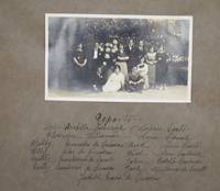
19202465<p>8-1/4 x 11 inches. 60pp recto only. Burgundy cloth photo album with gilt title and ornament stamped to spine brown paper leaves reinforced with cloth at the gutter. 55 b&w photographs 6 cyanotypes 3-1/2 x 5-1/2 inches each; holograph text in verse in Spanish. All but two photos are pasted in one per page; two additional photographs are laid in one a duplicate possibly removed from another album and one on a loose leaf of black construction paper and seemingly unrelated to the text. Light wear to spine ends and corners; front hinge gently split; light dampstaining to edge of front endpaper; text of one page smeared from contact with moisture although there is no damp-staining and the text is still readable.</p><p>An original proto-fotonovella relating in dramatic fashion the tale of four young couples who fall in love despite opposition from their guardians -- who it turns out are themselves a pair of star-crossed lovers who fell in love during an unnamed 19th-century war in the United States presumably the Civil War. Their tales are told through detailed staged photographs of amateur actors paired with occasionally rather clumsy verse.</p><p>The story begins with four sisters -- Betty Jilly Molly and Nelly -- who live with their stern spinster aunt Miss Arabella Arrowrock in a palatial home in New York City. The sisters are romantically involved with four brothers -- Dick Fred John and Jack -- who are under the care of their uncle Florentin Williamson. Although the brothers are supposed to be immersed in their studies they are much more interested in romance and sneak out to meet their beloveds standing on the girls' windowsills to woo them under cover of night. However they are spotted by a maid Judith who immediately reports to Miss Arrowrock that "instead of being asleep each one of the girls is at their window making love with strange men." </p><p>The young women and men get in serious trouble with their respective guardians and Arrowrock and Williamson forbid their charges from seeing their as-yet-unknown lovers again threatening to disown them if they disobey. Arrowrock and Williamson who are friends then meet and resolve to marry of their charges quickly not realizing that they are already intimately acquainted with each other. Neither the sisters nor the brothers know who the others' guardian is and the sisters hatch a plan to scare off their suitors through grotesque makeup and outlandish outfits. The brothers are disgusted but the sisters recognize them at once and all four couples secretly resume their relationships believing they are capable of duping their elders.</p><p>Naturally Arrowrock and Williamson overhear them gloating about their successful charade and are furious. Arrowrock sits on a bench to recover herself and Williamson approaches and recounts the story of how they met in their youth. An extended flashback scene follows set during what this cataloguer presumes is meant to be the American Civil War although that is never explicitly stated. Arrowrock like many daughters of the aristocracy worked as a nurse in a hospital tending to the war wounded and Williamson who was a soldier then was sent to the hospital to recover from being wounded. As Arrowrock nurses Williamson back to health he develops strong romantic feelings for her but never dares to tell her; even on their last night together when they both attend a ball at the close of the war Williamson can't work up the courage to confess his love.</p><p>Back in the present the nieces and nephews have been eavesdropping. They convince Arrowrock and Williamson to marry and let them marry each other since it was they who brought their aunt and uncle back together to make their feelings known. All five couples are then married simultaneously in a mass ceremony and the nieces leave home presumably to live with their new husbands; Arrowrock and Williamson remain in the former's palatial home.</p><p>The story's emphasis on finding true love is strongly reminiscent of the fotonovelas rosas pink photonovels or fotonovelas suaves smooth photonovels that were popular in the Spanish-speaking world in the mid-20th century albeit without some of the tropes of those later creations. Photonovels as we know them today emerged in Italy in the late 1940s and the present album presents as a sort of prototype of the photonovel resembling its content and use of visual narrative. It also has an extremely high production value for being homemade: the night scenes are presented in cyanotypes; indoor scenese that take place at night show electric lights switched on; and their are numerous costume changes and multiple extras.</p><p>A cast photo and list at the beginning reveals that many of the actors were related. That the fact that this album is likely unique or at least one of a very limited quantity and the photo laid in at the rear which seems to be of a real wedding between two older people in 1922 suggests that this may have been a keepsake or even a wedding gift. Moreover the album's final lines read "Y adios amigo lecter: esta historia . que ahora empieza / para ti ya termino." "Farewell dear reader: this story . which has now begun has for you now ended."</p> hardcover
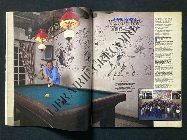
1985ABE-1548153040186140 PAGES-JEAN-EDERN HALLIER: ALLEZ LES VERTS, 3P, ACADEMIE FRANCAISE-CAROLINE, PHOTOS HELMUT NEWTON, 6P-FRANCIS HUSTER RODRIGUE A DU COEUR.102 PULSATIONS, 2P-ALBERT UDERZO, 4P, 5 PHOTOS-ALLO MOUROUSI? ICI L'ELYSEE, 2P-LE MENSONGE DE SOPHIE, ROLAND CHABERT, 4P-BOUVARD JOURNAL D'UN CONTRIBUABLE EN ENFER, 4P-LA "MAITRESSE" D'APOSTROPHES, JEANNE DE BERG, 2P, PHOTO-LA COUPOLE EN FOLIE, 4P, 2 PHOTOS-LA GUERRE DE SECESSION 2, 16P-ANNONCE POUR BARBARA ET GERARD DEPARDIEU AU ZENITH DE PARIS, LILY PASSION
18616001<p>Wood-engraved map with contemporary hand coloring engraved by Waters & Son New York with publisher's advertisement above map near contemporary marginal annotation to lower right margin which reads 'Position of Federal Army under General Maclellan sic July 1862 stretching towards the James River'; two closed tears in image carefully restored and barely visible a few other very minor repairs; a little fraying and some light discoloration at an old fold. 55.5 x 32.5 cms. Altogether a very nice example attractive.<br /></p><p>An attractive contemporary hand-colored very rare this edition not in the Library of Congress separately issued US Civil War map focusing on the area of Virginia and Maryland where the earliest battles were fought between the Union and Confederate armies and among the earliest broadside maps to specifically treat the battleground states in the growing conflict. Signaling its impartiality by prominently displaying both the Confederate and Federal flags the map represents the most recent news of the conflict in Virginia and Maryland from a British perspective as it was published in England and intended for a British audience. Britain was officially neutral in the American contest but had ardent sympathizers on both sides. Printed from a woodblock engraved by the New York firm Waters & Son the edition offered here is undated but must have appeared very early on around the time of the Battle of Bull Run the first important battle of the Civil War in July 1861. "Bull Run" the mapmaker states on the spot on the map where the actual battle was fought "is three miles from Manassas Junction between that point and Centreville." Water's engraving or its likeness would appear a number of times over the next several years with each edition or version bringing to the public's attention the most recent and sometimes climactic events of the war. Both American and British newspapers would report these events as they occurred and sometimes used an updated version of the Waters' woodblock as a full-page illustration. It is however particularly rare to find this map as a separately issued broadside printed on special paper such as the present contemporary hand colored example offered here. <br /></p><p>At the top of the sheet is text listing in separate columns the names of the Union and Confederate generals and a separate column for US exports in 1860. Notable is the enormous figure for US cotton which was exported primarily to England before the war nearly $192000 of $373000 of the total exports for the US economy – a statistic which must have reminded the British reader of the great cost the developing war would have on their textile industry. Much of the text is promotional. Bacon was perhaps the most important purveyor of American maps and atlases in England at the time and the representative for J.H. Colton one of the leading map publishers in the United States whose cartographic publications available from Bacon & Co. in England are prominently described and priced in the text.</p><p><b>A SHORT HISTORY OF THE MAP TO 1863</b></p><p>The earliest dated edition of Water's engraving which we were able to find appeared in the morning edition of the New York Herald on June 17 1861 Stevenson 451.3. Published a few weeks before the Battle of Bull Run specifically mentioned on our map but not in this newspaper version it notes in anticipation the number of troops amassing at Manassas Junction and on their way by train from the south. This edition was issued twice more on July 27 and September 11 the latter with no reference to the troops at Manassas. Another edition also entitled "Map of the Seat of War…." located at the BPL nearly identical to ours appeared in the London American Newspaper 1861. This version has an additional reference to the Battle of Bull Run below the map. All 3 of these maps found in <i>Stevenson's Civil War Maps</i> were published in newspapers. We find no reference to a separately issued broadside edition. Approximately a year later in an edition dated July 1862 Stevenson 452 the map once again appears this time updated to include Mc Clellan's position on the Peninsula which is shaded red as noted in several printed lines in the lower right corner. This latter is a handcolored broadside. The Library of Congress also has a similar example to ours though significantly modified published 2 years later in 1863 around the time of the invasion of Pennsylvania which replaces the historical and promotional text at the top of our sheet by extending the map north to include part of southern Pennsylvania and a list of Bacon's Shilling maps in the lower left hand corner Stevenson 476.5. This too is a colored broadside. In summary it appears that major battles or impending significant events such as Bull Run noted on ours and Mc Clellan's battle at Manassas may have been treated in a hand colored broadside publication. With the war continuing elsewhere the Waters' woodcut focusing on Virginia and Maryland became irrelevant to ongoing cartographic documentation of the war as battles moved from one locale to another in different parts of the country.</p><p>A handwritten contemporary annotation in the lower margin references a star added to the map by hand that updates it indicating the "Position of Federal Army under General Maclellan in July 1862 stretching towards the James River." Four minor punctures in the blank margins suggest that this copy was affixed to a wall at some point in its earlier history. A rare survival.</p><p>See Stephenson Richard. Civil War Maps An Annotated List of Maps and Atlases in the Library of Congress.</p>
18616001<p>Wood-engraved map with contemporary hand coloring engraved by Waters & Son New York with publisher's advertisement above map near contemporary marginal annotation to lower right margin which reads 'Position of Federal Army under General Maclellan sic July 1862 stretching towards the James River'; two closed tears in image carefully restored and barely visible a few other very minor repairs; a little fraying and some light discoloration at an old fold. 55.5 x 32.5 cms. Altogether a very nice example attractive.<br /></p><p>An attractive contemporary hand-colored very rare this edition not in the Library of Congress separately issued US Civil War map focusing on the area of Virginia and Maryland where the earliest battles were fought between the Union and Confederate armies and among the earliest broadside maps to specifically treat the battleground states in the growing conflict. Signaling its impartiality by prominently displaying both the Confederate and Federal flags the map represents the most recent news of the conflict in Virginia and Maryland from a British perspective as it was published in England and intended for a British audience. Britain was officially neutral in the American contest but had ardent sympathizers on both sides. Printed from a woodblock engraved by the New York firm Waters & Son the edition offered here is undated but must have appeared very early on around the time of the Battle of Bull Run the first important battle of the Civil War in July 1861. "Bull Run" the mapmaker states on the spot on the map where the actual battle was fought "is three miles from Manassas Junction between that point and Centreville." Water's engraving or its likeness would appear a number of times over the next several years with each edition or version bringing to the public's attention the most recent and sometimes climactic events of the war. Both American and British newspapers would report these events as they occurred and sometimes used an updated version of the Waters' woodblock as a full-page illustration. It is however particularly rare to find this map as a separately issued broadside printed on special paper such as the present contemporary hand colored example offered here. <br /></p><p>At the top of the sheet is text listing in separate columns the names of the Union and Confederate generals and a separate column for US exports in 1860. Notable is the enormous figure for US cotton which was exported primarily to England before the war nearly $192000 of $373000 of the total exports for the US economy – a statistic which must have reminded the British reader of the great cost the developing war would have on their textile industry. Much of the text is promotional. Bacon was perhaps the most important purveyor of American maps and atlases in England at the time and the representative for J.H. Colton one of the leading map publishers in the United States whose cartographic publications available from Bacon & Co. in England are prominently described and priced in the text.</p><p><b>A SHORT HISTORY OF THE MAP TO 1863</b></p><p>The earliest dated edition of Water's engraving which we were able to find appeared in the morning edition of the New York Herald on June 17 1861 Stevenson 451.3. Published a few weeks before the Battle of Bull Run specifically mentioned on our map but not in this newspaper version it notes in anticipation the number of troops amassing at Manassas Junction and on their way by train from the south. This edition was issued twice more on July 27 and September 11 the latter with no reference to the troops at Manassas. Another edition also entitled "Map of the Seat of War…." located at the BPL nearly identical to ours appeared in the London American Newspaper 1861. This version has an additional reference to the Battle of Bull Run below the map. All 3 of these maps found in <i>Stevenson's Civil War Maps</i> were published in newspapers. We find no reference to a separately issued broadside edition. Approximately a year later in an edition dated July 1862 Stevenson 452 the map once again appears this time updated to include Mc Clellan's position on the Peninsula which is shaded red as noted in several printed lines in the lower right corner. This latter is a handcolored broadside. The Library of Congress also has a similar example to ours though significantly modified published 2 years later in 1863 around the time of the invasion of Pennsylvania which replaces the historical and promotional text at the top of our sheet by extending the map north to include part of southern Pennsylvania and a list of Bacon's Shilling maps in the lower left hand corner Stevenson 476.5. This too is a colored broadside. In summary it appears that major battles or impending significant events such as Bull Run noted on ours and Mc Clellan's battle at Manassas may have been treated in a hand colored broadside publication. With the war continuing elsewhere the Waters' woodcut focusing on Virginia and Maryland became irrelevant to ongoing cartographic documentation of the war as battles moved from one locale to another in different parts of the country.</p><p>A handwritten contemporary annotation in the lower margin references a star added to the map by hand that updates it indicating the "Position of Federal Army under General Maclellan in July 1862 stretching towards the James River." Four minor punctures in the blank margins suggest that this copy was affixed to a wall at some point in its earlier history. A rare survival.</p><p>See Stephenson Richard. Civil War Maps An Annotated List of Maps and Atlases in the Library of Congress.</p> books
4 vols., 8vo., First Edition; cloth (blue/blue/red/green respectively), gilt backs, a near fine set in dustwrapper. The Starbuck Chronicles comprise: Rebel (1993); Copperhead (1994); Battle Flag (1995); The Bloody Ground (1996). All published to date, although the author has expressed a wish to continue the series. Dustwrapper artwork by Gino D'Achille. BRIGHT SET TO DATE OF AN OUTSTANDING HISTORICAL SEQUENCE.
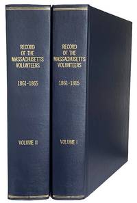
187044001Boston: Wright & Potter Printers to the State 1870. Thick4to. 29cm First Edition in 2 volumes 793 & 10851p. errata page rebound in full dark blue cloth gilt spine titles the paper is toned but sound marginal stain on the last few leaves on volume one the text is otherwise sound and clean a fine set. fine. Subjects<br /> A comprehensive two-volume official publication by the Adjutant General's Office documenting the service of state regiments during the Civil War. It details rosters service dates and histories for thousands of soldiers. ~ Content: contains roster lists battle summaries and records for soldiers in Massachusetts volunteer regiments. Volume I: Covers regiments 1-32 and 1st Heavy Artillery. Volume II: Covers regiments 33-62 2nd Heavy Artillery and various cavalry/light battery units. Wright & Potter, Printers to the State unknown
8vo., First Edition, with frontispiece and illustrations in the text; black cloth, gilt back, a very good, bright, clean copy in unclipped dustwrapper.
WB14168n.p.: n.p. n.d. Ephemera. Very Good. Broadside; 300x239mm; an 11 stanza poem plus the moral printed recto only in two columns within a decorative border; mounted to plain paper over cardboard. N.d. likely early 20th century. Flattened crease down the middle from folding; a few small closed tears along the edges; a few small specks of soiling. <br/><br/>A poem about an encounter with a British lion in New York's Central Park referencing the American Revolutionary War -- specifically the Trent Affair. Captain Charles Wilkes is mentioned by name as are Mason Slidell and others plus other well-known events such as Bunker Hill. Wilkes 1798-1877 was an American naval officer and explorer. He led the United States Exploring Expedition 1838-1842 and commanded the ship in the Trent Affair during the American Civil War 18611865 where he attacked a Royal Mail Ship almost leading to war between the U.S. and the UK. The moral of the poem is "If you wish to live in PEACE always be prepared for War; for a small matter kindleth a great fire! Large enough to set the world ablaze!" Very scarce none found on OCLC nor in the holdings of the NY Historical Society. n.p. unknown
WB14168n.p.: n.p. n.d. Ephemera. Very Good. Broadside; 300x239mm; an 11 stanza poem plus the moral printed recto only in two columns within a decorative border; mounted to plain paper over cardboard. N.d. likely early 20th century. Flattened crease down the middle from folding; a few small closed tears along the edges; a few small specks of soiling. <br/><br/>A poem about an encounter with a British lion in New York's Central Park referencing the American Revolutionary War -- specifically the Trent Affair. Captain Charles Wilkes is mentioned by name as are Mason Slidell and others plus other well-known events such as Bunker Hill. Wilkes 1798-1877 was an American naval officer and explorer. He led the United States Exploring Expedition 1838-1842 and commanded the ship in the Trent Affair during the American Civil War 18611865 where he attacked a Royal Mail Ship almost leading to war between the U.S. and the UK. The moral of the poem is "If you wish to live in PEACE always be prepared for War; for a small matter kindleth a great fire! Large enough to set the world ablaze!" Very scarce none found on OCLC nor in the holdings of the NY Historical Society. n.p. unknown books
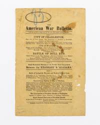
1870134066Port Elizabeth: Richards Impey & Co 1870. First Edition. Hardcover. Fair. Port Elizabeth Richards Impey & Co. circa 1870. One leaf 216 × 140 mm printed on both sides; paper tanned and marked with a few small holes and chips; mild signs of use; in decent condition now housed in a custom-made stiffened cloth folder. A rare South African handbill advertising a touring 'Diorama' of the American Civil War. The recto provides the sequence of events from the bombardment of Fort Sumter Bull Run the battle between the 'Kearsarge' and 'Alabama' the main battles from Gettysburg to General Lee's surrender at Appomattox and Lincoln's assassination and funeral. <p>The verso is headed 'For the Children visiting the American War Diorama' and contains a poem by Harry Stanley about an orphan boy at Christmas. This side has the imprint of T.H. Grocott Machine Printer Grahamstown. <p>Provenance: Geoffrey Ingleton with the G. & N. Ingleton bookplate inside the front flap of the portfolio and the Ingleton Collection catalogue inkstamp and number 10492 on the verso of the leaflet. Richards, Impey & Co hardcover
No marks or inscriptions. A very clean very tight copy with bright unmarked boards and no bumping to corners. Dust jacket not price clipped or marked or torn with slight creasing to edges. 288pp. A study of the Commander of Union Forces in the American Civil War, Ulysses Simpson Grant and his tactics and strategy in the fight against the Confederates. Illustrated.
186430878Philadelphia: J. Magee 1864. Broadside. Single sheet folded. Printed in blue and red on the first page only. Thirteen verses with chorus red and blue ornamental border with American flags and the words Liberty and Union Forever. Blindstamp of the Southworth Co. paper company of Massachusetts on the top left edge. Measures approximately 20 x 25 cm 8 x 10". The red part of the ornamental border is printed out of register. Faint pencil markings on the top edge and on the lower edge of the last page mild soiling. Very good. J. Magee unknown
No marks or inscriptions. No creasing to covers or to spine. A very clean very tight copy with bright unmarked laminated boards and no bumping to corners. 312pp. The Civil War was the defining event in American history. For each side, a way of life was gone - destroyed along with the battle-ravaged countryside and the hundreds of thousands of soldiers who were never to return. Although the North and South were very different at the start of the war, neither could return to its past. Their experiences are compared in this superb edition, with hundreds of illustrations from the period.
1990981ANew York, Knopf, (1990). 4°. 425 S. Mit zahlr. Fotos und farb. Karten aus dem amerikan. Bürgerkrieg. Wie neu! OHLn. im OU. Wie neu.
a88715Philadelphia 1863 believed to be first edition A. Winch. 5-1/2 x 3-3/4 inches 16p. Inch and half high engraving of eagle with ribbon imprinted with "Victory" held in his beak on front cover wraps. Fair quite worn cover soiled tips curled splitting at spine fold but complete. Three rubbed areas on rear panel have very very faint blue residue possibly from ink name or stamp since rubbed away but very hard to tell. Contains "37 sections". No tears in text. There is one copy in the Library of Congress but this once hated document is quite Rare. Pictures available on request. . paperback
8vo., First Edition thus, with 29 maps and plans in the text; handsomely bound in burgundy full crushed morocco, sides with gilt frame border, back with raised bands, second and fourth compartments ruled and lettered in gilt, all other compartments tooled in gilt, gilt top, hand-made endpapers, uncut, ribbon marker, a most attractive copy ideal as a gift or for presentation. A lovely copy of a scarce study by one of the foremost military strategists of the period.
8vo., with portrait frontispiece, coloured plate and numerous photographs (a number full-page) in the text; red cloth, upper board and backstrip blocked and lettered in gilt, a near fine copy in unclipped dustwrapper. Much-needed fascsimile reissue of the original edition of 1909.
8vo., First Edition, with portrait frontispiece, and illustrations and pedigrees in the text; grey cloth, gilt back, a near fine copy in unclipped dustwrapper.
8vo., First Edition thus, with portrait frontispiece and 8 maps (3 folding), free endpapers very faintly spotted; navy cloth, gilt back, gilt top, a near fine copy. FIRST UK EDITION OF MAHAN'S FIRST BOOK. THIS IS A PRESENTATION COPY FROM THE ADMIRALTY WITH ITS ENGRAVED ARMORIAL BOOKPLATE ON FRONT PASTE-DOWN; this copy awarded to Sub-Lieutenant G.H. Brady in 1902 for Meritorious Service. Hattendorf A1d.