Turgot, Etienne TurgotBiblio.com

178 résultats
3743462141.Gpaperback. Good. Access codes and supplements are not guaranteed with used items. May be an ex-library book. paperback
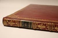
173948765Paris 1739. First Edition. Hardcover. Very Good. Turgot's Monumental Plan of Paris With Excellent Provenance. Elephant Folio 56.5 x 45.5 cm. A magnificent and complete example of the celebrated Plan de Paris commonly known as the Turgot Map housed in a handsome contemporary red Morocco binding with gilt borders spine compartments and bands. The arms of the city of Paris are gilt-stamped to both boards. Neatly rebacked; light rubbing and minor scuffing to the leather. Internally excellent: the sheets are remarkably bright clean and free from repair or loss with only some very faint marginal staining and a couple of spots throughout and the large folding spread with some light discolouration to a couple of the folded corners. Includes the full set of 20 engraved sheets with sheets 18 and 19 joined at the center and folded as issued. The title appears within the ornate cartouche on the key map. A small bookseller's ticket from the famed French antiquarian Pierre Berès is affixed to the upper fore-edge corner of the front paste-down. This is a superbly preserved example of one of the most extraordinary cartographic accomplishments of the 18th century. Commissioned in 1734 under the direction of Michel Étienne Turgot then Prévôt des Marchands Provost of the Merchants of Paris and a senior official in Louis XV's administration the map was designed to glorify the French capital as the political cultural and architectural heart of the kingdom. Louis Bretez a skilled draftsman and member of the Royal Academy of Painting and Sculpture was granted exclusive access to the interiors courtyards and rooftops of the city. Working in a dramatic bird's-eye axonometric perspective Bretez rendered the streets gardens landmarks and even individual buildings in intricate three-dimensional detail. The engravings were executed by Claude Lucas and the full project was completed in 1739 resulting in a masterwork of urban representation. Unlike conventional maps the Turgot Plan was conceived not merely as a geographic tool but as a grand artistic vision: part city portrait part political statement. It remains an unrivaled view of Paris under the Ancien Régime just decades before the French Revolution would transform the urban and social landscape. Widely distributed across France and to the royal courts of Europe the Turgot Map was intended to impress dignitaries scholars and ambassadors alike with the power and refinement of the French capital. Today complete copies in such fine condition are exceedingly scarce. This example with its contemporary binding and provenance would be a great addition for any serious collection of cartography Parisiana or French Enlightenment-era printing. Provenance: A Montreal family purchased from Christie's Canada with Montreal Book Auctions 1970. The Property of the Hon. Madame Georges P. Vanier. With a letter from the auction house and a letter from Parisian dealer Pierre Beres addressed to the buyer confirming this as the copy he sold to General Charles de Gaulle to present to the Governor General Vanier. hardcover
1334796416.Gpaperback. Good. Access codes and supplements are not guaranteed with used items. May be an ex-library book. paperback