8 362 résultats
ORD-6344Du 1er jour de Nivôse, an second de la République...Grasse. Guichard. An II. In-4 (181 x 235mm) de 3 pages imprimées. (2).
ORD-6371Décret de l'Assemblée Nationale du 17 Août 1792...Toulon. Mallard. 1792. In-4 (181 x 235mm) de 4 pages imprimées..
ORD-6372Du 26e jour de Frimaire, an second de la République...Paris. Imprimerie Nationale Exécutive du Louvre. An II. In-4 (181 x 235mm) de 8 pages imprimées. Signature manuscrite de Charles.
203176Paris, Imprimerie nationale, An IV in-8, 2 pp.,
203576Paris, Imprimerie nationale, s.d. in-8, 39 pp., en feuilles.
205834Paris, Imprimerie Nationale, (1791) in-8, 10 pp., dérelié.
ORD-6497Du 17e jour du 1er mois de l'an second de la République Française une & indivisible. Paris. Imprimerie Exécutive du Louvre. An II. In-4 (180 x 235mm) de 2 pages imprimées, signé Lauvan à la main.
1940_202000470Paris / Puteaux, Imp. Oller, Éditeurs, 1940 ; 287 x 218 mm, 32 pp.+ 3, cartonnage d'éditeur illustré et imprimé. Guide postal, télégraphique et téléphonique. Illustration «Pêcheur de brochet».
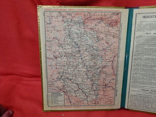
1942_202000469Rennes, Oberthur, Impr., Éditr., 1942 ; 264 x 213 mm, environ 20 pp., cartonnage d'éditeur illustré et imprimé. Carte postale, Télégraphique, Téléphonique et des Chemins de Fer du Dépt. De la Meuse. Carte des Chemins de Fer. Meuse - Service postal, Télégraphique et Téléphonique des Communes, etc. indicateur des Postes et des Télégraphes: 1° Régime intérieur. Poste aérienne. 2° Régime international. 3° Notions générales. 82. Émission des mandats étrangers. 83. Tarif des Colis postaux expédiés de la France continentale à destination de la Corse, de l'Algérie, de la Tunisie et les Colonies françaises. 84. Tarif des Colis postaux expédiés de la France continentale à destination des principaux pays étrangers. B. Services télégraphique et téléphonique. 39. Tarif télégraphique. - Régime intérieur. - Régime international. 39 bis. Cartes et Enveloppes pneumatiques. 40. Colonies et Étranger. Illustration «un Long Courrier» (bâtiment à voiles).
206711Paris, Imprimerie Nationale, (1790) in-8, 12 pp., dérelié.
ORD-6250Du 20e jour de Brumaire, an second de la République Française, une & indivisible. Paris. Imprimerie Nationale Exécutive du Louvre. An II. In-4 (181 x 235mm) de 4 pages imprimées. Signature manuscrite de Vian ou Viau.
ORD-6251Du 19 Août 1792, l'An quatrième de la Liberté. Toulon. Mallard. 1792. In-4 (181 x 235mm) de 4 pages imprimées.
ORD-6248Du 9e jour de Pluviôse, an second de la République... Paris. Imprimerie Nationale Exécutive du Louvre. An II. In-4 (181 x 235mm) de 4 pages imprimées. Signé Charles. Papier trés bruni et fragilisé.
ORD-6670Du 11e jour du 2e mois de l'an second de la République Française une & indivisible. Paris. Imprimerie Exécutive du Louvre. An II. In-4 (180 x 235mm) de 3 pages imprimées, signé Vian, à la main.
205862Paris, De l'Imprimerie de la République, An 3; in-8, 2 pp.,
222781S.l.n.d. (vers 1950) in-4, [4] ff. n. ch., couvertes d'une écriture à l'encre régulière et lisible (environ 30 lignes par page), avec initiales historiées et deux dessins dans le texte, le tout à l'aquarelle, en feuilles, reliées par un ruban azur.
Very Good Turkish, Ottoman (1500-1928) Original color map on cloth. Oblong: 67x75 cm. In Ottoman script. Folded originally. A very detailed map. Scale: 1:210.000. Shows Shkodra Lake, its shores, Bog Mountains, Karadag (Montenegro), Iakoh, Has etc. [MAP of OTTOMAN PROVINCE of BALKANS-ALBANIA] 52 Ipek (Peja). 53 Yakoh. 59 Akola. 60 Iskodra (Shkodra).
Very Good Turkish, Ottoman (1500-1928) Original color map. Folded. Very good. Large oblong 8vo. (21 x 26 cm). In Ottoman script. [MAP of OTTOMAN PROVINCE of DIYAR-I BEKR] Diyarbakir Vilâyeti. Province of Diyarbekir in Southeast Anatolia and its around. Many sandjaks and provinces with their detailed place names. Scale: 1/500.000.
Very Good Turkish, Ottoman (1500-1928) Original color map. Folded. Very good. Large oblong 8vo. (21 x 26 cm). In Ottoman script. [MAP of OTTOMAN PROVINCE of DIYAR-I BEKR] Diyarbakir Vilâyeti. Province of Diyarbekir in Southeast Anatolia and its around. Many sandjaks and provinces with their detailed place names. Scale: 1/1.500.000.
Very Good Turkish, Ottoman (1500-1928) Original color map. Folded. Very good. Large oblong 8vo. (21 x 26 cm). In Ottoman script. [MAP of OTTOMAN PROVINCE of EASTERN ROUMELI] Rumeli-yi Sarkî Vilâyeti, Bulgaristan Eyâleti, Edirne Vilâyeti, [Trakya], Selânik Vilâyeti. [East Roumeli, Salonica, Adrianople provinces; Old Zagra Sandjak, Bulgarian State]. Scale: 1/1.500.000. Ottoman Provinces in the Balkan Peninsula.
Very Good Turkish, Ottoman (1500-1928) Original color map. Folded. Very good. Large oblong 4to. (19 x 37 cm). In Ottoman script. [MAP of OTTOMAN PROVINCE of ERZURUM] Erzurum Vilâyeti. Province of Erzurum of east Anatolia and its around. Many sandjaks and provinces with their detailed place names. Scale: 1/1.500.000.
Very Good Turkish, Ottoman (1500-1928) Original color map. Folded. Very good. Oblong 4to. (21 x 42 cm). In Ottoman script. [MAP of OTTOMAN PROVINCE of KONIA] Konya Vlâyeti and around; Burdur, Isparta, Teke sandjaks, Hüdavendigâr Province Tozlu Ova, Tuz Gölü etc. Scale: 1/500.000.
Very Good Turkish, Ottoman (1500-1928) Original color map. Folded. Very good. Large oblong 8vo. (26 x 26 cm). In Ottoman script. [MAP of OTTOMAN PROVINCE of SIVAS] Sivas Vilâyeti, Trabzon Vilâyeti, Tokat Sancagi. [Sivas and Trabzon Provinces, Tokat Sandjak]. Scale: 1/1.500.000.
Very Good Turkish, Ottoman (1500-1928) Original color map. Folded. Very good. Obblong 4to. (21 x 38 cm). In Ottoman script. Scale:: 1/500.000. [MAP of OTTOMAN PROVINCE of TREBIZOND] Trabzon Vilâyeti, Trabzon Sancagi, Canik Sancagi, Sivas Vilâyeti. [Provinces of Trabzon and Sivas; Canik and Trebizond Sandjak]. Black Sea at north.