7 résultats
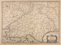
179440805London: Printed for A. Strahan and T. Cadell Edinburgh E. Balfour 1794. A very good copy small marginal tear just touching a blank section of map. 31 x 52 cm. Removed from: Robertson William Historical Disquisition concerning the knowledge which the ancients had of India. [Printed for A. Strahan and T. Cadell] [Edinburgh] [E. Balfour] unknown books
179440805London: Printed for A. Strahan and T. Cadell Edinburgh E. Balfour 1794. A very good copy small marginal tear just touching a blank section of map. 31 x 52 cm. Removed from: Robertson William Historical Disquisition concerning the knowledge which the ancients had of India. [Printed for A. Strahan and T. Cadell] [Edinburgh] [E. Balfour] unknown
1786RW1618Nancy:: Chez C. S. Lamort 1786. 1786. 4to. 2 vi 192 2 pp. 2 large folding zodiac maps. Title vignette full mottled calf leather gilt-stamped spine label raised bands; joints worn corners showing. Very good. Side-by-side translation of Ptolemy's Greek into French describing the position of the stars during Ptolemy's lifetime. / "Montignot has given us the original Greek and a French translation of the seventh book of Ptolemy's great work under the title of `Etat des etoiles fixes au second siecle' in quarto. He has given the designation of the same stars by Flamstead Flamsteed and Beyer and their position in the year 1786." – Thomas Jefferson to Joseph Willard. Chez C. S. Lamort, 1786. hardcover books
1730332605Amsterdam: R. & W. Wetstein William Smith 1730. unbound. Map. Copper plate engraving. Image measures 13.25" x 18".<br/> <br/> Printed circa 1730 this map of the Indian subcontinent was based on Ptolemy's 2nd century map and refined by Mercator beginning in the 16th century. This 1730 edition features graticule lines and a cartouche with a cherub. Covering an area from the Himalayan Mountains south to the Indian Ocean the map names many cities and topographical features. The map is in good condition wear to edges small tear to top of original center fold line. <br> <br> Gerard Mercator 1512-1594 was an accomplished mathematician cartographer globe maker and engraver best known for the Mercator Projection. Incorporating the newly accepted fact that the world is round Mercator was able to render longitude lines consistently straight on a chart. Although this requires some distortion it was of great use for navigators; furthermore it has since become historically important as it is still the most commonly used projection today.<br/> <br/> R. & W. Wetstein, William Smith unknown
174209570London: Printed for John and Paul Knapton at the Crown 1742 Book. Good. Hardcover. in the original full leather with five raised bands modestly worn both hinges cracked but holding no significant foxing all folding maps present and untorn very little wear inside. Printed for John and Paul Knapton at the Crown hardcover
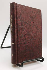
1786019210<p>London UK: M. Sibley 1786. Second Edition. Hardcover. Very Good. 219pp; Handsomely rebound in textured maroon boards with gilt titling to spine boards square clean & bright previous owner's name to title page pages lightly age-toned text unmarked binding is tight VG condition. Scarce antique volume on astrology originally written in Greek by Claudius Ptolemy c. 100-170s AD a Greco-Roman mathematician astronomer astrologer geographer and music theorist. This edition translated by John Whalley 1653-1724 "professor of physic and astrology and others" but with a reputation as a notorious Irish quack. The original Greek title was Tetrabiblos the Latin title was Quadripartitum and the volume is also known as Apotelesmatika.</p> M. Sibley hardcover
173076110Amsterdam:: Apud. R. & J. Wetstenios & Guil. Smith 1730. original pale blue boards; leather spine perished; sewn over tapes which are still largely intact. This copy lacks the last two leaf of the Index and the final blank leaf. . Folio. Added engraved illustrated title leaf; 28 fine maps on 56 leaves. Apud. R. & J. Wetstenios & Guil. Smith, hardcover