335 résultats
50 p. Petite déchirure à la couverture, coins de la couverture pliés. Inv. 25385
157418848Venetia (Venice), Giordano Ziletti, 1574-(73). 4to. Hcalf from ab 1820. Gilt back. Slight rubbing to spine. (78),350 pp. and 65 double-page engraved maps with text on verso of plates (130) pp,56,65 pp. 6 textlvs. at end with brownspots in right margin, sometimes a little browning to pages, few brownspots and a few textlvs. with minor wormtracts. Complete with all 65 maps called for, each measuring ab. 19 x 26 cm. A great part of the maps have some background shadowing from the printers ink, mainly due to the fact, that this is the third Ruscelli-edition, where the plates have been used before. 3 printer's wood-cut devices and 20 smaller and larger woodcuts in the text. 2 woodcuts with Ptolemy shown observing.
105903Lutetiæ Apud Gulielmum Cauellat 1556. 8 76 leaves. Illustrated with geometrical figures in the text. Contemporary vellum. Rebacked. Name erased from title-page. Occasional light foxing. . hardcover
152556635Strasbourg. 1525. Originalt tresnitt. Arkets størrelse : 535 cm X 395 cm. Latin. <br/><br/><em>Latinsk tekst. Bretten noe gulnet et par brunpletter.Med Kypros.Map of Palestine Mesopotamia and Babylonia in present day Middle East.Relief shown pictorially.Includes names of places and natural features.Descriptive text within ornamental borders on verso.Appears in the author's Geographia translated by Willibald Pirckheimer with annotations by Joannes Regiomontanus. Argentoragi i.e. Strasbourg : Iohannes Grieningerus communibus Iohannis Koberger impensis excudebat anno a Christi Natiuitate 1525 tertio Kalendas Apriles. Boston Public Library. </em> unknown
151354087Strasbourg. 1513. Originalt tresnitt. Arkets størrelse : 60 cm X 425 cm. Norsk. <br/><br/><em>“Martin Waldseemüller a highly accomplished scholar of geography merged the science of mapmaking and the art of printing in his 1513 atlas one of the most groundbraking documents in the history of cartography. He intended this atlas as a new edition of Ptolemy’s Geographia but included the addition of 20 modern maps which were not based upon the tradition of Ptolemy. Waldseemüller’s use of a quadratic plane projection was also a noteworthy advance.â€Martin Waldseemüller 1470-1520.Liten rift ved nedre marg. Et lite ormehull i venstre marg. Et par slitasjer i øvre marg. </em> unknown
18329Edited by Roy L. Moodie. Chicago, Illinois, University of Chicago Press, 1921 ; in-8, cartonnage d’éditeur de percaline vert foncé, titre doré au dos, XX, 372 pp., photographie assis en frontispice et 71 planches hors-texte dont 8 en couleurs.
167514546Paris, Guillaume Desprez, 1675 ; in-16 ; plein veau havane granité, dos à nerfs décoré et doré, titre doré, roulette sur les coupes (reliure de l'époque) ; (36) (titre, Epistre, Préface et Table), 457 pp., (1) p. de Privilège, 59 figures et schémas dont 13 hors-texte.
34705Leipzig B. G. Teubner 1963. Volume I: xxxi 461pp. ; Volume II: vi 446pp. Original cloth in dustwrapper worn on both volumes although the wrapper of volume I is significantly more worn than volume II. Numerous in-text diagrams and charts. The reverse endpaper of Volume I contains a loose constallations chart. A very good copy. German language text Leipzig, B. G. Teubner, 1963 hardcover
1956DL1160Louvain:: Bibliotheque de l'Universite Bureaux de Recueil 1956. 1956. Series: Universite de Louvain Recueil de Travaux d'Histoire et de Philologie 4th ser. fasc. 8. First edition. 8vo. 131 358 pp. 100 figs. Original printed wrappers. Ownership ink signature of David C. Lindberg. Very good. Bibliotheque de l'Universite Bureaux de Recueil, 1956. unknown
159616119Venice:: Giovanni Magini 1596-1598. Map 5 x 6.75 inches on 11.5 x 8 inch leaf. Single leaf from Giovanni Maginis Geographicae Ptolemaei 1597-1598. Revised edition of Ptolemys Geography. Copperplate engraved map of Asia. Latin text to map. Italian text to recto and verso of leaf. Large initial L below map. Engraved by Girolamo Porro. A fine impression. Scarce. Most suitable for framing. Map is 5 x 6.75 inches on leaf at 11.5 x 8 inches. Giovanni Antonio Magini 1555-1617 Italian astronomer astrologer cartographer and mathematician. Girolamo Porro 1520-1604 famous Italian engraver on wood and on copper. Maginis Geographia was first published in 1596 Latin and in 1597 & 1598 in Italian. The maps detailed and extremely attractive were engraved by the famous Porro. Authorities generally believe that they are the finest of the small size Ptolemies following those by Gastaldi done earlier. [Giovanni Magini,] unknown
195948400Madrid, Victoriano Suarez, 1959. 4°. Mit zahlr. meist ganzs. Abbildungen. 281 S., 2 Bll., Lwd. d. Zt. m. goldgepr. Rückentitel u. dem eingeb. OUmschlag.
31328, brepols, 2011 Hardback. 470 pages ., 3 b/w ill. 16 colour ill., 210 x 270 mm, Languages: English, Terraum orbis 8 ISBN 9782503523781.
2015R200130790Guy Trédaniel. 2015. In-8. Broché. Etat d'usage, Couv. légèrement pliée, Dos satisfaisant, Papier jauni. 184 pages, marque-page inclus - coins frottés.. . . . Classification Dewey : 130-Phénomènes paranormaux. Pseudo-sciences
c4899Paris, Imprimerie Nationale, 1951; plaquette in-4° brochée, couverture jaune pale imprimée en noir;7pp.
11791in 16 demi-chagrin rouge à nerfs et à coins, titre, caissons, filets, date en pied, dorés, filets dorés sur les plats. Faux-titre, titre, 119 pages, texte encadré d’un frise décorative, non rogné, tête dorée, gravures en couleurs de MEAULLE. Notices par A. PONS Paris A. QUANTIN imprimeur éditeur 1879. Très bon état
157418848Venetia Venice Giordano Ziletti 1574-73. 4to. Hcalf from ab 1820. Gilt back. Slight rubbing to spine. 78350 pp. and 65 double-page engraved maps with text on verso of plates 130 pp5665 pp. 6 textlvs. at end with brownspots in right margin sometimes a little browning to pages few brownspots and a few textlvs. with minor wormtracts. Complete with all 65 maps called for each measuring ab. 19 x 26 cm. A great part of the maps have some background shadowing from the printers ink mainly due to the fact that this is the third Ruscelli-edition where the plates have been used before. 3 printer's wood-cut devices and 20 smaller and larger woodcuts in the text. 2 woodcuts with Ptolemy shown observing. <br/><br/><em>Third edition of Ruscelli's translation from Venice 1561. The maps are printed from the same plates with the exception of Ptolemy's map of the world for which Malomba had returned to the original conical projection of Ptolemy. Moreover one map is added: the map of "Territorio di Roma". In general the maps are enlarged copies of Gastaldi's maps from the edition of 1548 which came out in 8vo. The Ruscelli translation contains an important innovation namely the division of the world map into two parts one for the Old World and one for the New as seen on the plate "Tavola Universal" depicting the 2 hemispheres. The atlas contains 27 ptolemaic maps and 38 new. 1 World 1 Hemisphere 10 Europe 4 Africa 12 Asia and 38 others. 10 of the maps relate to America.Philipps I:380. Sabin 66505. Nordenskiöld Nr. 34 p.27. </em> unknown
9293Paris, Librairie Académique Perrin, 1977 14 x 21, 429 pp., illustrations N/B, cartonnage éditeur + jaquette, bon état
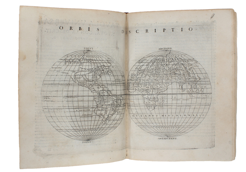
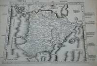
Frisches und sauberes Hardcover-Exemplar in gutem Zustand mit Original-Schutzumschlag. - Englisch. - Claudius Ptolemäus (altgriechisch Klaúdios Ptolemaíos, lateinisch Claudius Ptolomaeus; * um 100, möglicherweise in Ptolemais Hermeiou, Ägypten; † nach 160, vermutlich in Alexandria) war ein griechischer Mathematiker, Geograph, Astronom, Astrologe, Musiktheoretiker und Philosoph. Er lebte in Alexandria in der römischen Provinz Ägypten. Insbesondere seine drei Werke zur Astronomie, Geografie und Astrologie galten in Europa bis zur frühen Neuzeit als wissenschaftliche Standardwerke und wichtige Datensammlungen. Das geographische Werk hatte 561/62 noch Cassiodor in der Hand, doch erst mit der lateinischen Übersetzung einer Abschrift aus Konstantinopel, die in Florenz ab 1397 erfolgte, wurde die Geographike Hyphegesis wieder rezipiert. Ptolemäus verfasste die mathematiké sýntaxis ("mathematische Zusammenstellung"), später megíste sýntaxis ("größte Zusammenstellung"), heute Almagest genannte Abhandlung zur Mathematik und Astronomie in 13 Büchern. Dieses Werk blieb bis zum Ende des Mittelalters das Standardwerk der Astronomie im europäischen Raum. Es enthielt neben einem ausführlichen Sternenkatalog eine detaillierte Ausarbeitung des geozentrischen Weltbilds, die später nach ihm ptolemäisches Weltbild genannt wurde. … (wiki) // INHALT : List of Illustrations - Preface - Note on Citations of Classical Authors - Introduction - What Ptolemy Expected His Reader to Know - The Place of the Geography in Ptolemy's Work - Ptolemy's Evolving Conception of the World - Marinos and Other Sources - Ptolemy's Map Projections and Coordinate Lists - The Manuscripts of the Geography - The Maps in the Manuscripts - Early Readers and Translators - Modern Editions and Translations of the Geography - Our Translation - Ptolemy, Guide to Drawing a Map of the World - Book 1 - Book 2 - Book 7 - Book 8 - Plates and Maps - Notes on the Plates and Maps - Plates 1-7 following p. 128 - Maps 1-8 - Appendices - Appendix A: The Journeys of Flaccus and Maternus to the Aithiopians - Appendix B: Marinos' Calculation of the Latitude of Cape Prason - Appendix C: The Trade Route across Central Asia - Appendix D: The Breadth of the Mediterranean According to Marinos and Ptolemy - Appendix E: The Sail to Kattigara - Appendix F: The Miscellaneous Criticisms of Marinos' Data - Appendix G: Textual Notes - Appendix H: Geographical Index - Bibliography - Index. ISBN 9780691010427
1024156877.Ghardcover. Good. Access codes and supplements are not guaranteed with used items. May be an ex-library book. hardcover
101720411X.Ghardcover. Good. Access codes and supplements are not guaranteed with used items. May be an ex-library book. hardcover
1974028470Paris 1974 E. P. Denoël Hardcover Very Good 1st Edition
200181701Planeta–De Agostini 2001. Planeta–De Agostini unknown
1621B6798Padova: Paolo & Francesco Galignani. 1621. . Some toning interior otherwise clean and crisp. Edition: Second Italian edition. Binding: Recent full calf boards. Matching upper and lower with double blind panels gilt floral devices at corners of inner panel. Spine with 4 raised bands abbreviated title in gilt on maroon label in 2 remaining compartments with gilt devices and blind rules. Notes: Translated from Latin into Italian by Leonardo Cernoti Vinitiano.<br>Text in Italian. <br>A fine example of this monumental atlas and treatise on cartography considered to be the most influential cartographic and geographical account of the ancient world originally written by Ptolemy in Greek around 150 AD. <br><br>Claudius Ptolemy c.100 – c.170 AD was a mathematician astronomer astrologer and geographer living in the city of Alexandria then the Roman province of Egypt under Roman rule who wrote a number of scientific treatises that greatly influenced Byzantine Islamic and Western European science. His Geografia written around 150 AD is a thorough discussion on maps and the geographic knowledge of the Greco-Roman world and also serves as a handbook on how to draw maps using geographic coordinates for parts of the Roman world known at the time. Geografia draws from an earlier work by Marinus of Tyre now lost to us as well as various Roman and Persian gazetteers.<br>Geografia is divided into 8 books: book I is a treatise on cartography describing the methods used to assemble and arrange Ptolemy's data; from Book II through the beginning of Book VII a gazetteer provides longitude and latitude values for the world known to the ancient Romans; the rest of book VII provides details on three projections to be used for the construction of a map of the world varying in complexity and fidelity; book VIII constitutes an atlas of regional maps. The maps include a recapitulation of some of the values given earlier in the work which were intended to be used as captions to clarify the map's contents and maintain their accuracy during copying.<br>Geografia was translated into Arabic in the 9th century and Latin around 1406 and was a highly influential resource on the cartographic traditions of the medieval Caliphate and Renaissance Europe.<br><br> Size: Small Folio 301x 206 mm Illustration: Complete with 64 engraved maps 27 Ptolemaic 37 modern including the rare double-page world map “Orbis Terrae Compendiosa Descriptio†engraved by Girolamo Porro in addition to 14 in-text illustrations plus title vignette and chapter headpieces. Folio pagination. La Seconda Parte Della Geografia di Cl. Tolomeo…: title dated 1620; period marginalia in margins of 126v; 154 mispag. 174. Pg. 13 of Commentarii et Annotationi… unnumbered. Volume: 2 parts in 1 volume. References: Sabin 66506; Phillips Atlases 405; Adams M-118; Shirley 193-96 Pages: Blank 2. Title. 1597 dedication to Marco Cornaro from Gio. Battista & Giorgio Galignani. 1621 dedication to Marco Cornaro from Paolo & Francesco Galignani. Blank. Della Geografia di Claudio Tolomeo: p. 1-62. Commentarii et Annotationi dell’Eccell. Sig. Gio. Antonio Magini Padouano…: p. 1-21. Blank 2. Table of contents. Index 27. La Seconda Parte Della Geografia di Cl. Tolomeo…: p. 2-212. Blank. Index 59. Blank 3. Category: Book Atlas & Cartography; Paolo, & Francesco Galignani. hardcover
0243512473.Gpaperback. Good. Access codes and supplements are not guaranteed with used items. May be an ex-library book. paperback
0656926945.Ghardcover. Good. Access codes and supplements are not guaranteed with used items. May be an ex-library book. hardcover