Ptolemy; Girolamo RuscelliBiblio.com
235 résultats
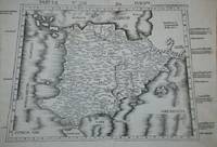
1574M7274Venice: Ruscelli c. 1574. Very Good;. Notes: Italian text on verso.<br>Girolamo Ruscelli 1518–1566 was an Italian mathematician and cartographer active in Venice during the early 16th century. Ruscelli is best known for his important revision of Ptolemy's Geographia published posthumously in 1574. Size : 192x266 mm 7.56x10.47 Inches Coloring: Hand Colored Category: Maps Asia Middle East Holy Land & Palestine;Maps Asia Middle East Jordan Syria Lebanon;Maps Asia Near East Turkey; Ruscelli unknown
1574M7271Venice: Ruscelli c. 1574. Very Good;. Notes: Italian text on verso.<br>Girolamo Ruscelli 1518–1566 was an Italian mathematician and cartographer active in Venice during the early 16th century. Ruscelli is best known for his important revision of Ptolemy's Geographia published posthumously in 1574. Size : 190x266 mm 7.48x10.47 Inches Coloring: Hand Colored Category: Maps Asia Near East Turkey; Ruscelli unknown
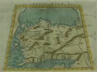
1574M7272Venice: Ruscelli c. 1574. Very Good;. Notes: Italian text on verso.<br>Map of the ancient region of Asiatic Sarmatia.<br>Girolamo Ruscelli 1518–1566 was an Italian mathematician and cartographer active in Venice during the early 16th century. He was also an alchemist writing pseudonymously as Alessio Piemontese.<br>Claudius Ptolemy better known mononymously as Ptolemy was a Greco-Roman mathematician astronomer astrologer geographer and music theorist who wrote about a dozen scientific treatises three of which were important to later Byzantine Islamic and Western European science. Size : 188x262 mm 7.40x10.31 Inches Coloring: Hand Colored Category: Maps Russia; Ruscelli unknown
1574M7278Venice: Ruscelli c. 1574. Very Good;. Notes: Italian text on verso.<br>Girolamo Ruscelli 1518–1566 was an Italian mathematician and cartographer active in Venice during the early 16th century. Ruscelli is best known for his important revision of Ptolemy's Geographia published posthumously in 1574. Size : 188x264 mm 7.40x10.39 Inches Coloring: Hand Colored Category: Maps Asia Central Afghanistan Pakistan; Ruscelli unknown
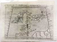
1574M11040Venice c.1574. Very Good. Notes: Map of the British Isles United Kingdom based on Ptolemy's map.<br>Girolamo Ruscelli 1518–1566 was an Italian mathematician and cartographer active in Venice during the early 16th century. Ruscelli is best known for his important revision of Ptolemy's Geographia published posthumously in 1574. Size : 190x262 mm 7.48x10.31 Inches Coloring: Black & White Category: Maps Europe United Kingdom; unknown
154115881Vienna 1541. Very good condition. The second map to show just southern Africa; it is based on the Waldseemuller modern map of southern Africa and derived from Ptolemy. Decoratively illustrated with African kings serpents an elephant and a Christian soldier riding a sea monster towards Madagascar. Three large rivers arise from a mountain range labeled 'Fontes Nili' source of the Nile other mountain ranges and coastal towns named in Latin or Portuguese. With the figure of the King of Portugal riding a sea monster towards Madagascar. <br /> <br /> Based on the slightly larger map from 1513 published in "Ptolemy's Geographia". The atlas was reprinted in 1520 1522 1525 1535 and 1541. This wood block was cut in 1525 for the publisher J.Grünninger. This being the variant of 1541 now without the banner title but title in letter type and blank verso.<br /> <br /> From the last edition of Ptolemy's "Geography" with maps by Laurens Fries and the text edited by Michael Servetus. Servetus was accused of heresy and burnt at the stake. Calvin ordered that copies of the book should be burnt with him although this copy seems to have eluded the flames. <br /> <br /> Wood block map with early hand color. Blank on the verso with the number 39 at the lower right corner. Image size: 16 7/8 x 13". Paper size: 21 1/4 x 15". Strengthened on the verso very faint browning at middle of center fold otherwise very good. Betz p. 55-56. Tooley "Map Collectors' Circle No. 30 Printed Maps of the Continent of Africa Part II" p. 61-62. Karrow "Mapmakers of the Sixteenth Century" unknown
151354087Strasbourg. 1513. Originalt tresnitt. Arkets størrelse : 60 cm X 425 cm. Norsk. <br/><br/><em>“Martin Waldseemüller a highly accomplished scholar of geography merged the science of mapmaking and the art of printing in his 1513 atlas one of the most groundbraking documents in the history of cartography. He intended this atlas as a new edition of Ptolemy’s Geographia but included the addition of 20 modern maps which were not based upon the tradition of Ptolemy. Waldseemüller’s use of a quadratic plane projection was also a noteworthy advance.â€Martin Waldseemüller 1470-1520.Liten rift ved nedre marg. Et lite ormehull i venstre marg. Et par slitasjer i øvre marg. </em> unknown
200181701Planeta–De Agostini 2001. Planeta–De Agostini unknown
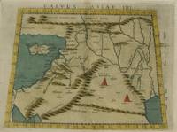
152556635Strasbourg. 1525. Originalt tresnitt. Arkets størrelse : 535 cm X 395 cm. Latin. <br/><br/><em>Latinsk tekst. Bretten noe gulnet et par brunpletter.Med Kypros.Map of Palestine Mesopotamia and Babylonia in present day Middle East.Relief shown pictorially.Includes names of places and natural features.Descriptive text within ornamental borders on verso.Appears in the author's Geographia translated by Willibald Pirckheimer with annotations by Joannes Regiomontanus. Argentoragi i.e. Strasbourg : Iohannes Grieningerus communibus Iohannis Koberger impensis excudebat anno a Christi Natiuitate 1525 tertio Kalendas Apriles. Boston Public Library. </em> unknown
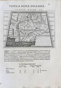
1598M8431Venice: G. Fratelli; G.A. Magini c. 1598. Very Good. Notes: Ptolemaic Map of Tabula Asiae X Plate 10 from "Geografia cioe Descrittione Universale della Terra" published by Magini c.1598. Text in Italian.<br><br><br><br> Size : 140x173 mm 5.50x6.80 Inches Coloring: Black & White Category: Maps Asia Central Afghanistan Pakistan; Maps Asia Central India & Sri Lanka / Ceylon; G. Fratelli; G.A. Magini unknown
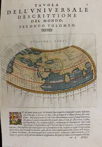
1597M7336Venice: Gio. Battista & Giorgio Galignani c. 1597. Very Good;. Notes: Text in Italian.<br>From Magini's "Geografia cioe Descrittione Universale della Terra".<br>The first edition of this map was printed with Latin text with the later issues printed in Italian.<br>"This quarto edition of Ptolemy was edited by the distinguished Italian geographer Giovanni Magini who also published as part of the same work the first reduced-size version of Mercator's atlas. The four world maps -- one ancient and three modern engravings -- are all by Girolamo Porro neatly copying other earlier works." Shirley Size : 135x175 mm 5.31x6.89 Inches Coloring: Hand Colored Reference: Shirley 193; Phillips 405. Category: Maps World; Gio. Battista & Giorgio Galignani unknown
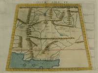
1598M8430Venice.: G. Fratelli; G.A. Magini c. 1598. Very Good. Notes: Ptolemaic Map of Tabula Asiae IX Plate 9 from "Geografia cioe Descrittione Universale della Terra" published by Magini c.1598. Text in Italian. Size : 140x173 mm 5.50x6.80 Inches Coloring: Black & White Category: Maps Asia Central Afghanistan Pakistan; Maps Asia Central Turkmenistan Uzbekistan Tajikistan Kyrgyzstan Kazakhstan; Maps Asia Central India & Sri Lanka / Ceylon; G. Fratelli; G.A. Magini unknown
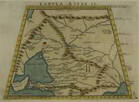
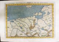
1574M11141Venice: Ruscelli c. 1574. Very Good. Notes: Italian text on verso.<br>Map of Prussia Poland Lithuania part of of Estonia and the Baltic Region.<br>Girolamo Ruscelli 1518–1566 was an Italian mathematician and cartographer active in Venice during the early 16th century. Ruscelli is best known for his important revision of Ptolemy's Geographia published posthumously in 1574. Size : 190x263 mm 7.48x10.35 Inches Coloring: Hand Colored Category: Maps Europe Poland Lithuania; Ruscelli unknown
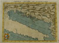
1574M7268Venice: Ruscelli c. 1574. Very Good;. Notes: Italian text on verso.<br>Girolamo Ruscelli 1518–1566 was an Italian mathematician and cartographer active in Venice during the early 16th century. Ruscelli is best known for his important revision of Ptolemy's Geographia published posthumously in 1574. Size : 190x261 mm 7.48x10.28 Inches Coloring: Hand Colored Category: Maps Europe Balkans; Ruscelli unknown
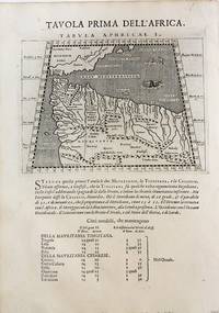
1598M8434Venice: G. Fratelli; G.A. Magini c. 1598. Very Good. Notes: Ptolemaic Map of the North west part of Africa Morocco Tabula Aphricae I Plate 1 from "Geografia cioe Descrittione Universale della Terra" published by Magini c.1598. Text in Italian.<br><br><br> Size : 140x173 mm 5.50x6.80 Inches Coloring: Black & White Category: Maps Africa North; Maps Africa West; G. Fratelli; G.A. Magini unknown
2005Q-1933303123Astrology Classics 2005-03-23. Paperback. New. In shrink wrap. Looks like an interesting title! Astrology Classics paperback
658618765Rowman & Littlefield Publishers Incorporated . Papeback. New. Rowman & Littlefield Publishers, Incorporated unknown
0674994795.Ghardcover. Good. Access codes and supplements are not guaranteed with used items. May be an ex-library book. hardcover
1936304<p>164 pages in dark blue cloth with gilt titling on spine. Second printing of this edition. Appendix contains extracts from Ptolemy's Almagest the whole of his Centiloquy and a diagram of the Zodiacal Planisphere with an explanation by J.M. Ashmand. Several diagrams and tables throughout. Previous owner's inscription on front pastedown. Hinges shaken possibly glued. One front free end paper razored out. A few check marks in the margins. Else pages are clean and unmarked. Binding is firm spine is square. Good. </p> The Aries Press hardcover
19801-0674994795Loeb Classical Library 1980. Hardcover. New. 466 pages. 6.75x4.50x1.00 inches. Loeb Classical Library hardcover
414456like new. unknown
0912504315.Ghardcover. Good. Access codes and supplements are not guaranteed with used items. May be an ex-library book. hardcover
19873674210Madrid.: Barath. 1987. Paperback. Cubierta deslucida. Good. 21 cm. 302 p. Encuadernación en tapa blanda de editorial ilustrada. Tetrabiblos. Traducción y notas de Demetrio Santos. Astrología. Obras anteriores a 1800. Santos Demetrio. 1924-2016. Quadripartitum. Astronomía . Cubierta deslucida. ISBN: 8485799011 9788485799015 null 133.52035.3"01" null 52 Ptolomeo Claudio null 52"01" Barath. paperback
198582721Franklin Center PA: Franklin Library. Very Good. 1985. Hardcover. Ptolemy's The Almagest is translated into English by R. Catesby Taliaferro. On the Revolutions of the Heavenly Spheres by Copernicus and Kepler's works are translated by Charles Glenn Wallis. Part of Franklin Library's Great Books series. Minor flaws to top side and bottom page edge gilts. Some pages very slightly wavy probably because they are thin because there are 1 085 pages in this book. Bound in full genuine brown leather with real gold trim gilded page edges a sewn-in satin bookmark and moire endpapers. ; 8vo 8" - 9" tall; 1085 pages . Franklin Library hardcover
2001Q-0380978229William Morrow 2001-07-24. Hardcover. New. In shrink wrap. Looks like an interesting title! William Morrow hardcover