GothaBiblio.com
98 résultats
1d608358. Jahrgang. Justus Perthes Verlag Gotha 1821. 12 Bll./136 S./24 bll./175 S. mit in Stahl gestochenem Frontispiz sowie 9 gestoch. Tafeln davon 3 doppelseitig und 1 gefalt. Stammbaum original illustr. Pbd. mit Goldschnitt. Duodez StaV. und Titel/gering fl. - gutes Exemplar - unknown
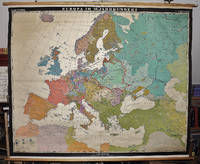
19632309280023Hermann Haack Geographisch-Kartographische Anstalt Gotha 1963. Maps. Good. Early Modern Europe in the 16th century 158 x 197 cm. Color map mounted on muslin wood rods top and bottom. Scale 1:3 000 000. <br> Note: This is a large heavy map. Additional postage will apply depending on delivery location Hermann Haack, Geographisch-Kartographische Anstalt, Gotha unknown
1993BN253006Augsburg : Maro-Verl. 1993. 1993. Herzog Ernst II. von Sachsen-Coburg und Gotha 1818 - 1893 und seine Zeit : Jubiläumsschrift im Auftrag der Städte Coburg und Gotha. hrsg. von Harald Bachmann . <br/><br/>Herzog Ernst II. von Sachsen-Coburg und Gotha 1818 - 1893 und seine Zeit : Jubiläumsschrift im Auftrag der Städte Coburg und Gotha. hrsg. von Harald Bachmann . Herzogtümer Sachsen-Coburg und Gotha - Bachmann Harald Augsburg : Maro-Verl. unknown
2007BN130554Hain 2007. 2007. Im Reich der Göttin Freiheit. Gothas fürstliche Gärten in 5 Jahrhunderten <br/><br/>Im Reich der Göttin Freiheit. Gothas fürstliche Gärten in 5 Jahrhunderten Stiftung Schloss Friedenstein Gotha Hrsg. Hain unknown
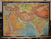
19562311280031EB Hermann Haack Geographisch-Kartographische Anstalt Gotha 1956. Maps. Very Good. Physical map of Asia and India 160 x 220 cm. Mounted on linen wood rods top and bottom. Middle hanging ring broken. Scale 1:3000000 E 25 00'--E 95 00'/ N 45 00'--N 10 00'. Shows international boundaries principal cities transportation facilities railways roads desert tracks waterways and petroleum pipe lines. Relief shown by hachures and spot heights. Depths shown by gradient tints form lines and soundings. Note: This is a large heavy map. Additional postage will apply depending on delivery location. EB Hermann Haack, Geographisch-Kartographische Anstalt, Gotha unknown
19682310050066VEB Hermann Haack Geographisch-Kartographische Anstalt Gotha 1968. Maps. Very Good. 20th Century Germany 160 x 225 cm. Mounted on muslin wood rods top and bottom Scale of sectional maps 1:450000. Relief shown by spot heights. Area includes part of the neighbouring countries in outline. Shows international boundaries administrative divisions towns by population symbols roads classified railways classified and landmarks. Editors: 1953-56 H.R. Fischer with W. Steinbruck; 1958-59 K. Witthauer; 1961- W. Steinbruck. VEB Hermann Haack Geographisch-Kartographische Anstalt, Gotha, unknown
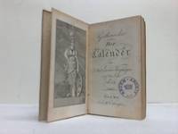
17694793Gotha Germany: Joh. Christian Dieterich 1769. Hardcover. Very Good. 24mo 74 176 pages; printed decorated covers stained rubber stamp on title-page all edges gilt. Scarce. <br/><br/>Copperplate engravings folding plate. Joh. Christian Dieterich hardcover
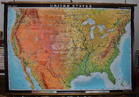
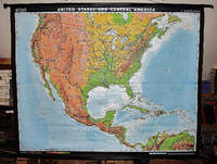
19642309280003Hermann Haack Geographisch-Kartographische Anstalt Gotha 1964. Maps. Very Good. Large physical map of the United States with state boundaries capitals and principal cities. 132 x 198 cm. Mounted on muslin wood rods top and bottom. Small tear crumbled edge on right outer margin. Scale 1:2500000. Denoyer-Geppert no. 15501. <br> Note: This is a large heavy map. Additional postage will apply depending on delivery location Hermann Haack Geographisch-Kartographische Anstalt Gotha unknown
2018BN71548Michael Imhof Verlag 2018. 2018. Der Gothaer Tafelaltar: Ein Monumentales Bilderbuch der Reformationszeit Ein Monumentales Bilderbuch der Reformationszeit <br/><br/> Michael Imhof Verlag unknown
1d6065C.W. Ettinger Verlag Gotha 1803. 30 Bll./98 S./13 Bll./114 S./6 Bll. mit 1 in Kupfer gestoch. Frontispiz. 3 lithogr. Portraittafeln 2 altcolorierten Modetafeln 9 Kupferstichtafeln sowie 1 gefalt. Geschlechter-Tafel original illustr. Pbd. mit Goldschnitt. Duodez StaV. und Titel. - gutes Exemplar - unknown
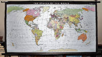
19932309280035Haack-Painke Firm Justus Perthes Gotha Germany 1993. Maps. Very Good. Political Map of the World in vivid color 146 x 78 cm. Color map mounted on rods top and bottom. Scale 1:24000000 W 180--E 180/N 80--S 70. "Best.-Nr. 362331144." Note: This is a large heavy map. Additional postage will apply depending on delivery location. Haack-Painke (Firm), Justus Perthes (Gotha, Germany) unknown
20012309280019Justus Perthes Verlag Gotha 2001. Maps. Like New. 0x0x0. 123 x 185 cm. Color mounted on roller with leather strap and metal bracket. Scale 1:18000000. W 60--E 180/N 80--S 40. <br> Note: This is a large heavy map. Additional postage will apply depending on delivery location Justus Perthes Verlag, Gotha unknown
2015BN71201d/m/z Druckmedienzentrum Gotha Betriebs GmbH 2015. 2015. Gotha 1250 Jahre der Weltgeschichte 775-2025 <br/><br/> d/m/z Druckmedienzentrum Gotha Betriebs GmbH unknown
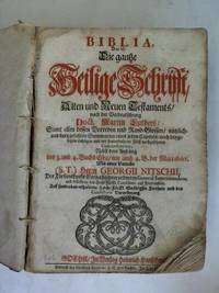
1f9825Heinrich Hanschens Gotha 1712. 26 nn. Blätter 698 474 324 S. 2 Blatt Halbleder der Zeit Gelenke gebrochen/ ein Einbanddeckel lose/ 2 Kanten fehlen/ mit einigen Eselsohren/ teils fleckig. - für das Fürstentum Gotha edierte Bibel mit den Privilegien des Herzogs - unknown
#[27812]Illustrated i.a. with four double plates each with 8 engraved handcoloured flags of European countries and towns: "tableau des pavillons de poupe des principales puissances maritimes de l'Europe ". On the pages II - IV some remarks on the illustrated flags. unknown
20022309210164Justus Perthes Verlag Gotha GmbH Gotha 2002. Maps. Like New. 122 x 188 cm. Color map mounted on wood rods top and bottom. Scale 1:18000000. 362333043 <br> Note: This is a large heavy map. Additional postage will apply depending on delivery location. Justus Perthes Verlag Gotha GmbH, Gotha unknown
20012309210166Klett Perthes 2001. Maps. Like New. 149 x 193 cm. Color map mounted on wood rods top and bottom. 1:3500000. Physical map features detailed topographic relief shading as well as ocean depths. Mountain ranges peaks rivers swamps and urban areas are all indicated on the map. <br> Note: This is a large heavy map. Additional postage will apply depending on delivery location. Klett Perthes unknown
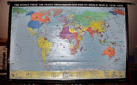
20012309210163Justus Perthes Verlag Gotha GmbH Gotha 2001. Maps. Like New. 0x0x0. 100 x 178 cm. Color map mounted on wood rods top and bottom. Scale 1:18000000. <br> Note: This is a large heavy map. Additional postage will apply depending on delivery location. Justus Perthes Verlag Gotha GmbH, Gotha unknown
BN106274Nomos. Softcover. Grenzen und Auslegung autonom harmonisierten Wirtschaftsprivatrechts <br/><br/>Grenzen und Auslegung autonom harmonisierten Wirtschaftsprivatrechts Nomos paperback
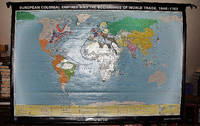
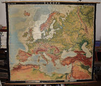
19642309210067A.J. Nystrom ; Justus Perthes Chicago Darmstadt Germany 1964. Maps. Very Good. Large pull down topographic color map of modern Europe. Fitted with metal rod for wall mounting. 185 x 208 cm. 73 1/2 x 81 1/2 inches. Mounted on muslin and fitted with rods. Relief shown by shading gradient tints and spot heights. Depths shown by gradient tints. Shows direction of ocean currents in the Mediterranean Sea and in the Atlantic Ocean. Note: This is a large heavy map. Additional postage will apply depending on delivery location. A.J. Nystrom ; Justus Perthes, Chicago, Darmstadt, Germany unknown
187148013Gotha Justus Perthes 1871-1931. 12mo a. small 8vo. Bound in 61 orig. red full cloth gilt spines and gilt frontcovers. 8 vols having loose spines or lacking spines or covers detached. Stamp to titlepage or htitles. With engraved portraits. Internally generally fine. With 2 supplementsvolumes to 1883 and 1884. 2 orig. full cloth. hardcover
1867019545Gotha Justus Perthes. 1867. This is a portfolio of 81 maps and drawings. No previous owner's names not exlibrary. Hand colored in outline. Overall in VERY GOOD condition. Photos available upon request. Size: 18.5 x 15 inches 46 x 31 cms. LARGE. Hand colored in outline. Overall in GOOD condition. Photos available upon request. Size: 18.5 x 15 inches 46 x 31 cms. LARGE. This portfolio has 3 extra maps variants of other ones present and it is lacking the following 6 maps: #12. Europa zur Ubersicht der politischen Verhaltnisse; #39. Asia. Generalkarte; #41a. America. Generalkarte; #43c. China ostl. Theil Korea und Japan; #44c. Di Ostindischen Inseln; #51. Polynesian und der Grosse Ocean. Westl. Theil. JOHAN GEORG JUSTUS PERTHES 1749-1816 German publisher was born at Rudolstadt on the Iith of September 1 749. In 1785 he founded at Gotha the business which bears his name Justus Perthes. In this he was joined in 1814 by his son Wilhelm 1793-1853 who had been in the establishment of Justus' nephew Friedrich Christoph Perthes at Hamburg. On the death of Justus at Gotha on the 2nd of May 1816 Wilhelm took entire control of the firm. He laid the foundation of the geographical branch of the business for which it is chiefly famous by publishing the Hand-atlas 1817-1823 of Adolf Stieler 1775-1836. Wilhelm Perthes engaged the collaboration of the most eminent German geographers of the time including Heinrich Berghaus Christian Gottlieb Reichard 1758-1837 who was associated with Stieler in the compilation of the atlas Karl Spruner 1803-1892 and Emil von Sydow 1812-1873. The business passed to his son Bernard Wilhelm Perthes 1821-1857 who was associated with August Petermann under whose direction the well-known periodical Petermanns Mitteilungen was founded and Bruno Hassenstein 1839-1902; and subsequently to his son Bernard 1857-. In 1863 the firm first issued the Almanach de Gotha a statistical historical and genealogical annual in French of the various countries of the world; and in 1866 the elaborate Geographisches Jahrbuch was produced under the editorship of Ernst Behm 1830-1884 on whose death it was continued under that of Professor Hermann Wagner. . Disbound. Very Good. Elephant Folio - over 15" - 23" tall. Hardcover. Gotha Justus Perthes. Paperback
2016127386Arnoldsche Verlagsanstalt. New. 2016. Hardcover. 3897904136 . FREE UPGRADE to Courier/Priority Shipping Upon Request - IN STOCK AND IMMEDIATELY AVAILABLE FOR SHIPMENT - Flawless copy brand new pristine never opened. Text in German. -- with a bonus offer-- . Arnoldsche Verlagsanstalt hardcover