590 résultats
4030(San Francisco), Priaprism Press, (Last Gasp), (International Presse Magazine), (1998-1999). 3 volumes grands in-8 (29,8 cm) 57,(1) pages; 62 pages; 64 pages, illustrés de bandes dessinées érotiques en couleurs. Couvertures souples illustrées en couleurs. Bel état général.
13335
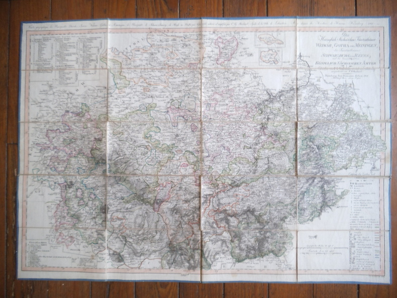
Carte géographique des Principautés Ducales Saxones. Weimar, Gotha et Meiningen, des Principautés de Schwarzbourg, de Reuss. Dressée par Güssefeld achevée et amplifiée par C.G REICHARD. Syndic de la ville dé Lobenstein-Aux dépens des héritiers de Hommans Nuremberg 1811. Belle carte en couleurs, entoilée, format 840x600mm.
20012309210166Klett Perthes 2001. Maps. Like New. 149 x 193 cm. Color map mounted on wood rods top and bottom. 1:3500000. Physical map features detailed topographic relief shading as well as ocean depths. Mountain ranges peaks rivers swamps and urban areas are all indicated on the map. <br> Note: This is a large heavy map. Additional postage will apply depending on delivery location. Klett Perthes unknown
19932309280035Haack-Painke Firm Justus Perthes Gotha Germany 1993. Maps. Very Good. Political Map of the World in vivid color 146 x 78 cm. Color map mounted on rods top and bottom. Scale 1:24000000 W 180--E 180/N 80--S 70. "Best.-Nr. 362331144." Note: This is a large heavy map. Additional postage will apply depending on delivery location. Haack-Painke (Firm), Justus Perthes (Gotha, Germany) unknown
19932311280067Justus Perthes Gotha Germany 1993. Maps. Like New. Africa and Most of Europe 120 x 97 cm. Mounted color map metal roller. Scale 1:10000000. W 30--E 70/N 50--S 40. Relief shown by shading and spot heights. Note: This is a large heavy map. Additional postage will apply depending on delivery location. Justus Perthes, Gotha, Germany unknown
201391171Berlin, De Gruyter 2013. 161 Seiten. Hardcover/Pappeinband
2702Gotha, chez Justus Perthes, 1887 - pet. in-fol., 54 pp. - rel. percaline bleue, titre doré en belles cursives à chaud 1 er plat, cachet de l'armée allemande de la 2nde guerre mondiale
1970645ABKöln 1970. 4°. Mit zahlr. (tls. farb.) Abb. 284 S. OLwd.- Gutes Ex.
1860910654CG[Um 1860]. Lithographie 16,5 x 25 cm, Blattgröße 22,5 x 32 cm.
19692124186Darmstadt: Wissenschaftliche Buchgesellschaft (WBG) (Lizenzausgabe der Deutschen Verlags-Anstalt) 1969. VIII, 398 Seiten. Gr. 8° (22,5-25 cm). Orig.-Leinenband. [Hardcover / fest gebunden].
18572139341Gotha: Friedrich Andreas Perthes 1857. VIII, 547, (5) Seiten. Frakturdruck. Mit gestochenem Portrait Claudius, montiert als Frontispiz und einer kleinen Titelillustration. Weiteres gestochenes Porträt Anna Rebekka Claudius' auf festem Karton eingebunden. 8° (17,5-22,5 cm) Guter, schöner Halblederband der Zeit mit Buntpapierbezug und gesprenkeltem Schnitt. [Hardcover / fest gebunden].
199438940Opladen : Leske und Budrich, 1994. 407 S. : Ill., graph. Darst., Kt. ; 21 cm broschiert
19682311280081Hermann Haack Geographisch-Kartographische Anstalt Gotha 1968. Maps. Acceptable. 149 x 207 cm. Color map mounted on muslin wooden rods top and bottom. Tear at top of map near wooden rod some chips. Scale 1:3000000. E 65--E 150/N 57--N 15 Relief shown by shading hypsometric tints form lines and spot heights. 84 inches wide by 65 inches tall. The . Note: This is a large heavy map. Additional postage will apply depending on delivery location. Hermann Haack Geographisch-Kartographische Anstalt Gotha unknown
19682310050066VEB Hermann Haack Geographisch-Kartographische Anstalt Gotha 1968. Maps. Very Good. 20th Century Germany 160 x 225 cm. Mounted on muslin wood rods top and bottom Scale of sectional maps 1:450000. Relief shown by spot heights. Area includes part of the neighbouring countries in outline. Shows international boundaries administrative divisions towns by population symbols roads classified railways classified and landmarks. Editors: 1953-56 H.R. Fischer with W. Steinbruck; 1958-59 K. Witthauer; 1961- W. Steinbruck. VEB Hermann Haack Geographisch-Kartographische Anstalt, Gotha, unknown
19672309280029Haack Gotha 1967. Maps. Very Good. 122 x 210 cm. Color map mounted on muslin wood rods top and bottom. Cartography by Olbricht and Haefke. Relief shown by contours shading gradient tints and spot heights. Depths shown by gradient tints and soundings. "VLN 1001 . Nr.8/64/67-10/67-1000." Scale 1:20000000. Note: This is a large heavy map. Additional postage will apply depending on delivery location Haack, Gotha unknown
19642309210067A.J. Nystrom ; Justus Perthes Chicago Darmstadt Germany 1964. Maps. Very Good. Large pull down topographic color map of modern Europe. Fitted with metal rod for wall mounting. 185 x 208 cm. 73 1/2 x 81 1/2 inches. Mounted on muslin and fitted with rods. Relief shown by shading gradient tints and spot heights. Depths shown by gradient tints. Shows direction of ocean currents in the Mediterranean Sea and in the Atlantic Ocean. Note: This is a large heavy map. Additional postage will apply depending on delivery location. A.J. Nystrom ; Justus Perthes, Chicago, Darmstadt, Germany unknown
19562311280031EB Hermann Haack Geographisch-Kartographische Anstalt Gotha 1956. Maps. Very Good. Physical map of Asia and India 160 x 220 cm. Mounted on linen wood rods top and bottom. Middle hanging ring broken. Scale 1:3000000 E 25 00'--E 95 00'/ N 45 00'--N 10 00'. Shows international boundaries principal cities transportation facilities railways roads desert tracks waterways and petroleum pipe lines. Relief shown by hachures and spot heights. Depths shown by gradient tints form lines and soundings. Note: This is a large heavy map. Additional postage will apply depending on delivery location. EB Hermann Haack, Geographisch-Kartographische Anstalt, Gotha unknown
19642309280003Hermann Haack Geographisch-Kartographische Anstalt Gotha 1964. Maps. Very Good. Large physical map of the United States with state boundaries capitals and principal cities. 132 x 198 cm. Mounted on muslin wood rods top and bottom. Small tear crumbled edge on right outer margin. Scale 1:2500000. Denoyer-Geppert no. 15501. <br> Note: This is a large heavy map. Additional postage will apply depending on delivery location Hermann Haack Geographisch-Kartographische Anstalt Gotha unknown
19303115080Gotha: Leopold Klotz 1930. XII, 87 Seiten. Gr. 8° (23,5 x 15 cm). Orig.-Broschur. [Softcover / Paperback].
190896718Gotha: Perthes 1908. (2), 74 Seiten. 8° (17,5-22,5 cm). Orig.-Interimsbroschur. [Softcover / Paperback].
189496714Gotha: Perthes 1894. (2), 83 Seiten. 8° (17,5-22,5 cm). Orig.-Interimsbroschur. [Softcover / Paperback].
1925154382Gotha & Stuttgart: Verlag Friedrich Andreas Perthes 1925. XXIV, 103 Seiten. Frakturdruck. 8° (17,5-22,5 cm). Orig.-Broschur. [Softcover / Paperback].
1993BN253006Augsburg : Maro-Verl. 1993. 1993. Herzog Ernst II. von Sachsen-Coburg und Gotha 1818 - 1893 und seine Zeit : Jubiläumsschrift im Auftrag der Städte Coburg und Gotha. hrsg. von Harald Bachmann . <br/><br/>Herzog Ernst II. von Sachsen-Coburg und Gotha 1818 - 1893 und seine Zeit : Jubiläumsschrift im Auftrag der Städte Coburg und Gotha. hrsg. von Harald Bachmann . Herzogtümer Sachsen-Coburg und Gotha - Bachmann Harald Augsburg : Maro-Verl. unknown
199350908Augsburg : Maro-Verl. 1993. 488 S. : Ill. ; 24 cm gebundene Ausgabe, Hardcover/Pappeinband, Exemplar in gutem Erhaltungszustand
196096327Weimar: Hermann Böhlaus Nachf. 1960. XII, 313 Seiten. Mit 2 Faltkarten. Gr. 8° (22,5-25 cm). Orig.-Leinenband mit goldgeprägtem Titel auf Deckel und Rücken. [Hardcover / fest gebunden].