Gotha, GothaBiblio.com
98 résultats
0656751053.Gpaperback. Good. Access codes and supplements are not guaranteed with used items. May be an ex-library book. paperback
1143348192.Gpaperback. Good. Access codes and supplements are not guaranteed with used items. May be an ex-library book. paperback
1143454707.Gpaperback. Good. Access codes and supplements are not guaranteed with used items. May be an ex-library book. paperback
1016754388.Ghardcover. Good. Access codes and supplements are not guaranteed with used items. May be an ex-library book. hardcover
20012309210166Klett Perthes 2001. Maps. Like New. 149 x 193 cm. Color map mounted on wood rods top and bottom. 1:3500000. Physical map features detailed topographic relief shading as well as ocean depths. Mountain ranges peaks rivers swamps and urban areas are all indicated on the map. <br> Note: This is a large heavy map. Additional postage will apply depending on delivery location. Klett Perthes unknown
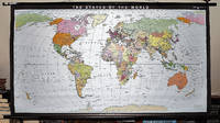
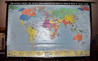
19932309280035Haack-Painke Firm Justus Perthes Gotha Germany 1993. Maps. Very Good. Political Map of the World in vivid color 146 x 78 cm. Color map mounted on rods top and bottom. Scale 1:24000000 W 180--E 180/N 80--S 70. "Best.-Nr. 362331144." Note: This is a large heavy map. Additional postage will apply depending on delivery location. Haack-Painke (Firm), Justus Perthes (Gotha, Germany) unknown
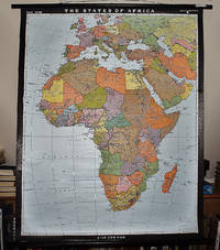
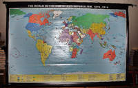
19932311280067Justus Perthes Gotha Germany 1993. Maps. Like New. Africa and Most of Europe 120 x 97 cm. Mounted color map metal roller. Scale 1:10000000. W 30--E 70/N 50--S 40. Relief shown by shading and spot heights. Note: This is a large heavy map. Additional postage will apply depending on delivery location. Justus Perthes, Gotha, Germany unknown
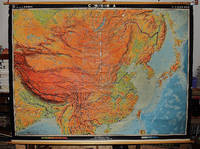
19682311280081Hermann Haack Geographisch-Kartographische Anstalt Gotha 1968. Maps. Acceptable. 149 x 207 cm. Color map mounted on muslin wooden rods top and bottom. Tear at top of map near wooden rod some chips. Scale 1:3000000. E 65--E 150/N 57--N 15 Relief shown by shading hypsometric tints form lines and spot heights. 84 inches wide by 65 inches tall. The . Note: This is a large heavy map. Additional postage will apply depending on delivery location. Hermann Haack Geographisch-Kartographische Anstalt Gotha unknown
19682310050066VEB Hermann Haack Geographisch-Kartographische Anstalt Gotha 1968. Maps. Very Good. 20th Century Germany 160 x 225 cm. Mounted on muslin wood rods top and bottom Scale of sectional maps 1:450000. Relief shown by spot heights. Area includes part of the neighbouring countries in outline. Shows international boundaries administrative divisions towns by population symbols roads classified railways classified and landmarks. Editors: 1953-56 H.R. Fischer with W. Steinbruck; 1958-59 K. Witthauer; 1961- W. Steinbruck. VEB Hermann Haack Geographisch-Kartographische Anstalt, Gotha, unknown
19672309280029Haack Gotha 1967. Maps. Very Good. 122 x 210 cm. Color map mounted on muslin wood rods top and bottom. Cartography by Olbricht and Haefke. Relief shown by contours shading gradient tints and spot heights. Depths shown by gradient tints and soundings. "VLN 1001 . Nr.8/64/67-10/67-1000." Scale 1:20000000. Note: This is a large heavy map. Additional postage will apply depending on delivery location Haack, Gotha unknown
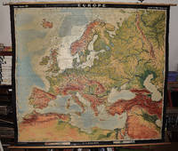
19642309210067A.J. Nystrom ; Justus Perthes Chicago Darmstadt Germany 1964. Maps. Very Good. Large pull down topographic color map of modern Europe. Fitted with metal rod for wall mounting. 185 x 208 cm. 73 1/2 x 81 1/2 inches. Mounted on muslin and fitted with rods. Relief shown by shading gradient tints and spot heights. Depths shown by gradient tints. Shows direction of ocean currents in the Mediterranean Sea and in the Atlantic Ocean. Note: This is a large heavy map. Additional postage will apply depending on delivery location. A.J. Nystrom ; Justus Perthes, Chicago, Darmstadt, Germany unknown
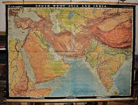
19562311280031EB Hermann Haack Geographisch-Kartographische Anstalt Gotha 1956. Maps. Very Good. Physical map of Asia and India 160 x 220 cm. Mounted on linen wood rods top and bottom. Middle hanging ring broken. Scale 1:3000000 E 25 00'--E 95 00'/ N 45 00'--N 10 00'. Shows international boundaries principal cities transportation facilities railways roads desert tracks waterways and petroleum pipe lines. Relief shown by hachures and spot heights. Depths shown by gradient tints form lines and soundings. Note: This is a large heavy map. Additional postage will apply depending on delivery location. EB Hermann Haack, Geographisch-Kartographische Anstalt, Gotha unknown
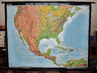
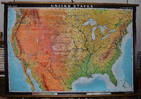
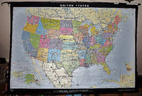
19642309280003Hermann Haack Geographisch-Kartographische Anstalt Gotha 1964. Maps. Very Good. Large physical map of the United States with state boundaries capitals and principal cities. 132 x 198 cm. Mounted on muslin wood rods top and bottom. Small tear crumbled edge on right outer margin. Scale 1:2500000. Denoyer-Geppert no. 15501. <br> Note: This is a large heavy map. Additional postage will apply depending on delivery location Hermann Haack Geographisch-Kartographische Anstalt Gotha unknown
1993BN253006Augsburg : Maro-Verl. 1993. 1993. Herzog Ernst II. von Sachsen-Coburg und Gotha 1818 - 1893 und seine Zeit : Jubiläumsschrift im Auftrag der Städte Coburg und Gotha. hrsg. von Harald Bachmann . <br/><br/>Herzog Ernst II. von Sachsen-Coburg und Gotha 1818 - 1893 und seine Zeit : Jubiläumsschrift im Auftrag der Städte Coburg und Gotha. hrsg. von Harald Bachmann . Herzogtümer Sachsen-Coburg und Gotha - Bachmann Harald Augsburg : Maro-Verl. unknown
2026__3731915693Imhof Verlag 2026. Hardcover. New. 304 pages. German language. 8.66x1.02x10.63 inches. Imhof Verlag hardcover
1944207007-11-1-29Eurohistory.com. First Edition. Very Good. With dust jacket. It's a well-cared-for item that has seen limited use. The item may show minor signs of wear. All the text is legible with all pages included. It may have slight markings and/or highlighting. Eurohistory.com unknown
19989168-ALast Gasp/Priaprism Press 1998. softcover. Fine. 8x12. OVERSIZE BOOK - shipping may be increased accordingly especially on International orders. Last Gasp/Priaprism Press paperback
205067International Presse Magazine . hardcover. gebraucht wie neu . International Presse Magazine hardcover
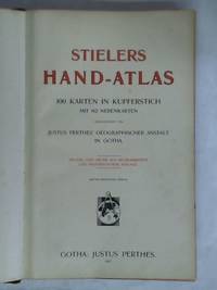
1J97169. von Grund aus neubearbeitete und neugestochene Auflage Dritter berichtigter Abdruck Justus Perthes Gotha 1907. 2 S. Inhalt 100 doppelblattgroße Kartenseiten 2 238 S. Alphabetisches Namenverzeichnis im Anhang Halbleder-Einband mit Goldprägung und farbigem Schnitt folio teils etwas fleckig/etwas berieben/Gelenke mit leichten Einrissen/Rückendeckel wasserfleckig/Vorderdeckel teils fleckig. unknown
274353Almanach de Gotha / John Kennedy 2003. Duodecimo red cloth boards gilt lettering and design to front & spine 1124pp nr. FINE sl. soiling to page edge minor & prev. owner's details in ink to fep. Almanach de Gotha / John Kennedy 2003 hardcover
274354Almanach de Gotha / John Kennedy 2001. Duodecimo yellow cloth boards black lettering and design to front & spine xiv880pp nr. FINE sl. soiling to page edge minor & prev. owner's details in ink to fep. Almanach de Gotha / John Kennedy 2001 hardcover
20012309280019Justus Perthes Verlag Gotha 2001. Maps. Like New. 0x0x0. 123 x 185 cm. Color mounted on roller with leather strap and metal bracket. Scale 1:18000000. W 60--E 180/N 80--S 40. <br> Note: This is a large heavy map. Additional postage will apply depending on delivery location Justus Perthes Verlag, Gotha unknown
20022309210164Justus Perthes Verlag Gotha GmbH Gotha 2002. Maps. Like New. 122 x 188 cm. Color map mounted on wood rods top and bottom. Scale 1:18000000. 362333043 <br> Note: This is a large heavy map. Additional postage will apply depending on delivery location. Justus Perthes Verlag Gotha GmbH, Gotha unknown
20012309210163Justus Perthes Verlag Gotha GmbH Gotha 2001. Maps. Like New. 0x0x0. 100 x 178 cm. Color map mounted on wood rods top and bottom. Scale 1:18000000. <br> Note: This is a large heavy map. Additional postage will apply depending on delivery location. Justus Perthes Verlag Gotha GmbH, Gotha unknown
19982311280070Justus Perthes Verlag Gotha Germany 1998. Maps. Like New. Double sided map of the United States 93 x 141 cm. Color maps. Scale 1:4000000. W 125--W 65/N 49--N 24. Notes:Includes physical map on one side and political map on the other. Relief shown by shading gradient tints and spot heights; ocean depths shown by gradient tints and spot depths. "1098"--Physical "1198"--Political. "Bestell-Nr. 362331644." Ancillary maps: Hawaii -- Alaska. Note: This is a large heavy map. Additional postage will apply depending on delivery location. Justus Perthes Verlag, Gotha [Germany] unknown