Hess, Ulrich (Bearb.)Antiquariat.de

192 résultats
196096327Weimar: Hermann Böhlaus Nachf. 1960. XII, 313 Seiten. Mit 2 Faltkarten. Gr. 8° (22,5-25 cm). Orig.-Leinenband mit goldgeprägtem Titel auf Deckel und Rücken. [Hardcover / fest gebunden].
199939293Ostfildern-Ruit : Gerd Hatje, 1999. 359 S. : zahlr. Ill. ; 28 cm broschiert
192631608Hannover: Akademischer Verein Gotha 1926. Gebunden. Akademischer Verein Gotha unknown
19263132851Gotha: Leopold Klotz 1926. 17 Seiten. Frakturdruck. Mit 1 Tafel. 8° (17,5-22,5 cm). Orig.-Broschur. [Softcover / Paperback].
192754903ABBerlin-Schöneberg, Peter J. Oestergaard Verlag, 1927. 8° (19x13), 295 S., mit zahlr. Bildtafeln in braunem Kupfertiefdruck, flex OLdr mit goldPrägung, Kopfgoldschnitt, nahezu ungelesen, schönes gepflegtes Exemplar,
192756691ABBerlin-Schöneberg, Peter J. Oestergaard Verlag, 1927. 8° (19x13), 295 S., mit zahlr. Bildtafeln in braunem Kupfertiefdruck, OHldr mit reicher goldRückenPrägung, fest sauber und gepflegt,
191211538Weimar, Kyffhäuser, 1912. Jg. 1 (1912). LXII, 1 Bl., 607 S. 1 Tafel. Kl.-8°. OLwd. (Gebrssprn, etw. bestoßen. kl. Randläsuren).
19941083551994 Editions Aerospace / AIRtime - 1994 - In-4, cartonnage bleu sous jaquette illustrée en couleurs de l'éditeur - 254 p. - Très riche iconographie in-texte en couleurs et en N&B
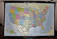
19982311280070Justus Perthes Verlag Gotha Germany 1998. Maps. Like New. Double sided map of the United States 93 x 141 cm. Color maps. Scale 1:4000000. W 125--W 65/N 49--N 24. Notes:Includes physical map on one side and political map on the other. Relief shown by shading gradient tints and spot heights; ocean depths shown by gradient tints and spot depths. "1098"--Physical "1198"--Political. "Bestell-Nr. 362331644." Ancillary maps: Hawaii -- Alaska. Note: This is a large heavy map. Additional postage will apply depending on delivery location. Justus Perthes Verlag, Gotha [Germany] unknown
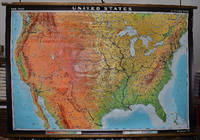
19642309280003Hermann Haack Geographisch-Kartographische Anstalt Gotha 1964. Maps. Very Good. Large physical map of the United States with state boundaries capitals and principal cities. 132 x 198 cm. Mounted on muslin wood rods top and bottom. Small tear crumbled edge on right outer margin. Scale 1:2500000. Denoyer-Geppert no. 15501. <br> Note: This is a large heavy map. Additional postage will apply depending on delivery location Hermann Haack Geographisch-Kartographische Anstalt Gotha unknown
1998365<p>Tight square uncreased spine. Clean unmarked interior. Some bumped corners and light edge-wear but nice solid copy overall. 64 pp. Oversized.</p> Last Gasp paperback
19989168-ALast Gasp/Priaprism Press 1998. softcover. Fine. 8x12. OVERSIZE BOOK - shipping may be increased accordingly especially on International orders. Last Gasp/Priaprism Press paperback
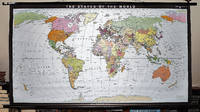
19932309280035Haack-Painke Firm Justus Perthes Gotha Germany 1993. Maps. Very Good. Political Map of the World in vivid color 146 x 78 cm. Color map mounted on rods top and bottom. Scale 1:24000000 W 180--E 180/N 80--S 70. "Best.-Nr. 362331144." Note: This is a large heavy map. Additional postage will apply depending on delivery location. Haack-Painke (Firm), Justus Perthes (Gotha, Germany) unknown
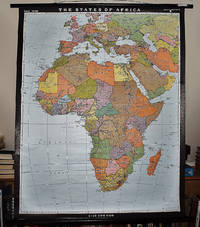
19932311280067Justus Perthes Gotha Germany 1993. Maps. Like New. Africa and Most of Europe 120 x 97 cm. Mounted color map metal roller. Scale 1:10000000. W 30--E 70/N 50--S 40. Relief shown by shading and spot heights. Note: This is a large heavy map. Additional postage will apply depending on delivery location. Justus Perthes, Gotha, Germany unknown
19301313AG1930 (ca.). ORadierung, 7 x 11,5 (H) (Text integr.) Auf Wunsch Digitalaufnahme in jpg-Format erhältlich- photo in jpg-format available. Je nach Versandart können die Portokosten bis zu 2 ? weniger als angegeben betragen.+
197856341ABStuttgart, DVA Deutsche Verlags-Anstalt, 1978. 8° (22x14), 402 S., 1 Bl., mit dokumentarischem Tafelteil, OPbd mit ill OU, Umschlag etwas lichtverfärbt, nahezu ungelesen, schönes gepflegtes Exemplar,
199438940Opladen : Leske und Budrich, 1994. 407 S. : Ill., graph. Darst., Kt. ; 21 cm broschiert
193286361Druck: Gotha, Engelhardt-Reyher 1932. * 1 nn. Bl., 136 S. 22,5 x 14,5 cm. Original-Broschur. (Mitteilungen des Vereins für Gothaische Geschichte und Altertumsforschung; Beiheft zum Jahrgang 1932 und 1933).
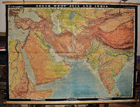
19562311280031EB Hermann Haack Geographisch-Kartographische Anstalt Gotha 1956. Maps. Very Good. Physical map of Asia and India 160 x 220 cm. Mounted on linen wood rods top and bottom. Middle hanging ring broken. Scale 1:3000000 E 25 00'--E 95 00'/ N 45 00'--N 10 00'. Shows international boundaries principal cities transportation facilities railways roads desert tracks waterways and petroleum pipe lines. Relief shown by hachures and spot heights. Depths shown by gradient tints form lines and soundings. Note: This is a large heavy map. Additional postage will apply depending on delivery location. EB Hermann Haack, Geographisch-Kartographische Anstalt, Gotha unknown
19922480BBGotha, Museen der Stadt Gotha, 1992. 28 cm. 229 S., zahlr. Ill., graph. Darst. O. kart. sehr gut. Zust.
1995565BBGotha, Gothaer Kultur- und Fremdenverkehrsbetrieb, 1995. 28 cm. 216 S. : zahlr. Ill. kart. neuwertig
1934162019Gotha: Klotz Verlag 1934. 119 Seiten. Frakturdruck. Gr. 8° (22,5-25 cm). Orig.-Broschur. [Softcover / Paperback].
1985G06456-2Kornhochheim : Eigenverlag, 1985. Abb., 90 S., 4°, als Manuskript gedruckt.
191161462München, Selbstverlag des Central-Vereins für Kirchenbau, 1911. Ill.-Orig.-Broschur, 4°, 18 Bll. Mit Wappen-Abb. Von Otto Hupp.Doppelblatt: Herzogtum Sachsen Koburg und Gotha .
1949105337Gotha: Engelhard-Reyher-Verlag 1949. 175 Seiten. 8° (17,5-22,5 cm). Orig.-Halbleinenband. [Hardcover / fest gebunden].