Jouve (Paul ; 1878-1973), peintre et sculpteur animalier :Livre Rare Book
610 résultats
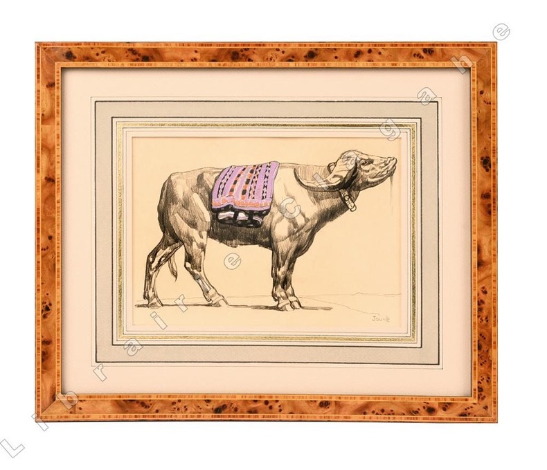
185221442Dessin original au crayon gras, gouache et aquarelle sur papier japon impérial (185 x 217 mm ; recadré 151 x 212), signé au crayon dans le coin inférieur droit ; passe-partout à large encadrement bicolore beige et vert et large filet doré, encadrement de loupe. Format total 295 x 355 mm. Au dos, partie de dessin au crayon et fusin, découpée.
15880031131588 A Paris, Chez Hierosme de Marnef & la veufve Guillaume Cavellat, 1588. Petit in-quarto (165 X 222) veau marbré, double filet doré et guirlande dorée en place des nerfs, caissons dorés, pièce de titre maroquin grenat, encadrement de filet noir sur les plats, coupes filetées, tranches rouges (reliure XVIIIe) ; (1) f. blanc, titre, (11) ff. (épitre, préface, table et portrait), 468 pages, (1) f. (achevé d'imprimer et marque de l'imprimeur). Restaurations à deux angles et un mors. Exemplaire un peu court de marge en tête mais sans atteinte au texte, infime travail de vers dans la marge inférieure des premiers feuillets, à peine visible ; cerne de mouillure claire dans la marge inférieure des cinq premiers feuillets, minuscule manque de papier en pied des deux premiers feuillets (feuillet blanc et titre).
Very Good Turkish, Ottoman (1500-1928) Original full leather bdg. with its miklep (traditional flap), embossed shamsa (mystical sun) on boards. Roy. 8vo. (24 x 17 cm). In Ottoman script. [8], 263 p. Sarlavla page decorated with traditional ornaments. First edition of this extremely rare and the first translation of the Anabasis of Alexander in the Ottoman / Turkish literature. One of 1010 copies. The Anabasis of Alexander was composed by Arrian of Nicomedia in the second century AD, most probably during the reign of Hadrian. The Anabasis (which survives complete in seven books) is a history of the campaigns of Alexander the Great, specifically his conquest of the Persian Empire between 336 and 323 BC. Both the unusual title "Anabasis" (literally "a journey up-country from the sea") and the work's seven-book structure reflect Arrian's emulation (in structure, style, and content) of the Greek historian Xenophon, whose own Anabasis in seven books concerned the earlier campaign "up-country" of Cyrus the Younger in 401 BC. The Anabasis is by far the fullest surviving account of Alexander's conquest of the Persian Empire. It primarily revolves around the military history, reflecting the content of Arrian's model, Xenophon's Anabasis; the work begins with Alexander's accession to the Macedonian throne in 336 BC and has nothing to say about Alexander's early life (in contrast, say, to Plutarch's Life of Alexander). Nor does Arrian aim to provide a complete history of the Greek-speaking world during Alexander's reign. Arrian's chief sources for his writing of the Anabasis were the lost contemporary histories of the campaign by Ptolemy and Aristobulus and, for his later books, Nearchus. One of Arrian's main aims in writing this work on history seems to have been to correct the standard "Vulgate" narrative of Alexander's reign that was dominant in his own day, primarily associated with the lost writings of the historian Cleitarchus. The Anabasis gives a broadly chronological account of the reign of Alexander the Great of Macedonia (336-323 BC), with a particular focus on military matters. George Rhasis (Yorgaki Razi) translated Anabasis Alexandrou = "History of Alexander the son of Philip" the work of Xenophon under the title "Târîh-i Iskender bin Filipos". This is the first translation of an ancient Greek historian into Turkish. Georgios Rhasis, who was one of the first writers of the French-Turkish dictionary in the early period, was an Ottoman intellectual who worked as an instructor and translator in Ottoman and French languages. He also taught at the Eastern Languages School in Paris and continued her studies in Corfu and Paris. In 1821 he came to be in Istanbul as a famous orientalist. Rhasis left the city and the homeland he lived in to settle in Tsarist Russia due to concerns during the Greek Revolution in 1821. The Bulaq or El-Amiriya Press is the first official and governmental printing press to be established in Egypt, and functions according to industrial printing basis, causing not just a qualitative but also a quantitative and knowledgeable leap in science throughout the Arab region. It's established in 1820 by Muhammad Ali Pasha of Egypt and Sudan (1769-1849) and it was part of Muhammad Ali's inclusive development plans for the modernization of Egypt. Library of Congress, Karl Süssheim Collection, no. 129. (OCLC: 966315151). Only 6 copies in OCLC: 27236333.; Alex II 25.; BM e15.; Cairo FKT 166.; IstUKT 802.; Bianchi CD 155.; Bulaq IF 8:21.; Bulaq FK 7:8.; Ridwan 162.; Özege 19837 (No author and no translator in Özege record).
Very Good Turkish, Ottoman (1500-1928) Extremely rare huge chromo-lithograph map in 24 sheets mounted on canvas, showing a large zone including Midyat (Mardin), Mosul, Mt. Cilo (Resko-Buzul) on the southeast; Kahta (Adiyaman), Munzur Mt., Divrigi (Sivas) on the west; the Black Sea on north and Turkish borders to Armenia, Azerbaijan on the east, and to Russia on the northeast. In addition shows in separate little portions, roads, mountains and hills, lakes, and telegraph and post ways and borders in that zone. Not in any libraries and any collection. An attractive map with its huge size and decorative surface. Several toponyms are underlined in red ink. Otherwise a very good example. Original folded map mounted on canvas. 118x112 cm. In Ottoman script (Turkish with Arabic letters). Scale: 1/630.000.
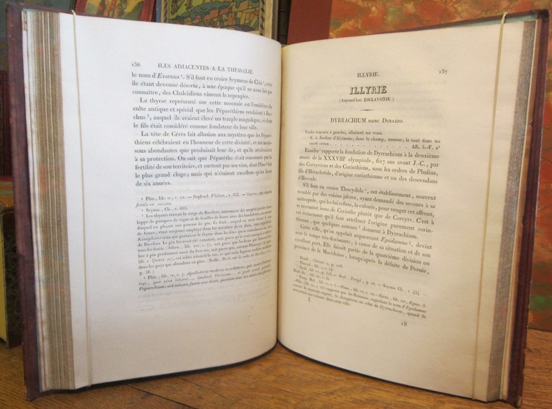
1683GITj822(Paris chez Denys Thierry 1683). Petit in-8 paginé 109 à 209. Cartonnage bradel du XIXe siècle de papier ocellé rouge, jaune, bleu, pièce de titre grenat en long sur le dos "Manesson-Mallet Balkans, Turquie d'Europe". Orné de 49 planches à pleine page numérotées XLV à XCIV composées de 1 portrait, 1 plan, 4 de costumes, 10 vues et 33 cartes, toutes colorées à l'époque. Manques de papier en tête et en queue du dos du cartonnage, occasionnant la fragilité du mors du 1er plat, intérieur complet pour les sujets traités et de la plus grande fraîcheur. CHAPITRES IX ET X EXTRAITS DU TOME III DE L'EDITION ORIGINALE PARUE EN 1683 *chapitre IX Turquie d'Europe paginé 109 à 167, intitulé de l'Illyrie et de la Grèce selon les Anciens, de la Turquie d'Europe (Septentrionale et Méridionale) *Chapitre X paginé 168 à 209 intitulé des Isles de l'archipel qui sont vers l'Europe (Iles de la Mer Egée, Cyclades et Ioniennes). Toutes planches (appelées ici figures) sont très habilement aquarellées avec de belles teintes vives. Celles qui intéressent directement la Turquie représentent: Portrait du Sultan Mehmet IV, Costume du Grand Turc, Costume traditionnel d'un Turc et d'une Turque, Costume d'un Spahis et de 2 Janissaires (sur une seule planche), Plan de Constantinople, vues de Constantinople, Château des 7 Tours, du Sérail (avant et arrière), Cathédrale-Mosquée Sainte Sophie (2 vues), 4 cartes (Turquie d'Europe Septentrionale, Turquie d'Europe Méridionale). La Grèce est représentée par des cartes (Grèce en général, Grèce en particulier, cartes des Cyclades et des îles Ioniennes de la Mer Egée), 2 vues de Candie (Crète), ville et labyrinthe. Les autres planches ont pour sujet: l'Illyrie; Dace et Thrace; Pannonie et Illyrie; Rhetie et Vindelécie; Moldavie et Transilvanie; Hongrie; Macédoine; Thessalie et Epire; 1 costume traditionnel Hongrois; une vue de Waradin, une de Bude, une de Presbourg, Sestos, Abydos et le Détroit de Gallipoli. 6 cartes sont reproduites 2 fois avec une numérotation différente: XLVI et XLVII (Dace et Thrace), LI et LII (Macédoine, Thessalie, Epire), LXII et LXIII (Turquie Méridionale), LXXVIII et LXXIX (Schiro et Nègrepont), LXXX et LXXXI (Andro et Tiré), LXXXIX et XC (île de Candie). CE FRAGMENT COMPLET POUR LES SUJETS TRAITES PERMET D'APPR2CIER LA FINESSE ET LA BEAUTE DES FIGURES DE L'OUVRAGE DE MANESSON-MALLET.
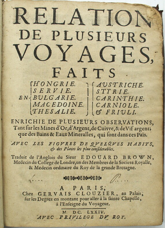
1674PHO-1910A Paris, Chez Gervais Clousier, 1674. In-4, 3ff.-208pp., relié plein veau époque, dos à nerfs, frottements, manque en coin et au dos, manque de papier en coin, surlignages, quelques brunissures. Titre frontispice gravé par Cossin d'après P. Mignard, 9 planches dont 4 dépliantes.
Very Good Turkish, Ottoman (1500-1928) Paperback. Chipped on margins. Some owner notes. Otherwise a good copy. Roy. 8vo. (24 x 18 cm). In Ottoman script. 32 p. This rare book includes the royal travel of Sultan Abdülmecid in 1262 AH [1846 AD] to Roumelia. From Edirne, Abdülmecid proceeded to Eski Zagra (Stara Zagora), Kizanlik (Kazanluk), Gabrova (Gabrovo), Tirnova (Turnovo), Rusçuk (Ruse), Silistre (Silistra), and Varna. The route of the 1846 tour followed closely, except in reverse order, Mahmud II's tour of 1837. According to witness accounts, along the way, the sultan was greeted everywhere with poetic recitations and songs of praise and prayer, both in Ottoman and Bulgarian. The pride of place among welcoming parties invariably fell on students, of all creeds, most clad in white uniforms, some in solemn church-going attire, with flowers and green branches in their hands. At every stop, ceremonial cannon salvos were fired during the day and elaborate firework illuminations were performed at night. In the town of Kizanlik, known then as now for the most fragrant roses and the best rose oil, the sultan's visit coincided, possibly by design, with the rose harvesting season. So the locals sprinkled rose water and poured rose oil before the sultan's cavalcade. According to Hristo Stambolski, in the three days of the sultan's stay in town, no rose harvesting was done so that the whole area would be exquisitely scented in his honor. For his part, the sultan had doctors vaccinate all children against smallpox in public before sending each one off with a small gift of money. Even people with rare diseases were, on occasion, summoned to the sultan's presence so his doctors could cure them. The sublime visit caused the locals, who were unaccustomed to direct contact with the center of power, quite a stir. The most detailed account, albeit from a hostile source, relates the sultan's visit to Rusçuk, which, at four days, may have also been the longest. According to Nayden Gerov, the greeting ceremonies proceeded on a communal basis, with the Jews being placed closest to the town walls, next to them the Armenians, then the Bulgarians, and finally, the Muslims, situated the farthest from town, yet being the first to see and welcome the sultan. As the sultan approached, each group of youngsters would in turn sing for him, everyone else bowing profusely. Based on Gerov's description, it seems that Abdülmecid was dressed in a slightly more luxurious fashion than during state ceremonies in Istanbul. ((Source: Sultan Abdülmecid's Tour of Rumelia and the Trope of Love by Stephanov). The sultan began to travel by the way of the gate of Yedikule in Istanbul in May 6, 1846. He followed the way of Ayastefanos, Silivri, Çorlu, Burgaz, Edirne, Zagra-i Atik, Kizanli, Trnova, Rusçuk, Silistre, Rusçuk, Shumnu, and Varna and came back to Istanbul by way of the sea on June 14, 1846. During this travel, the Sultan listened to people's problems and ordered the authorities to be solved with those problems. He received successful military and administrative authorities in settlements on the way of travel and rewarded them. He also received the governors of Serbia, Eflak and Bogdan, and the representatives of foreign states. With this travel, the Sultan aimed to strengthen the connection to the center of people and administrators in provinces. Özege 17910. First Edition.
17540047921754 Paris, Gandouin, 1754. Trois volumes in-quarto (203 X 259 mm) veau fauve marbré, dos cinq nerfs, caissons dorés ornés, pièces de titre et de tomaison, coupes ornées, tranches rouges (reliure de l’époque). Tome I : (3) ff. de faux-titre, titre et privilège, X pages de préface, XLVIII pages, 421 pages, (1) page et (1) f. d'errata, 51 planches - Tome II : (2) ff. de faux-titre et titre, IX-477 pages, (1) f. d'errata, 22 planches - Tome III : (2) ff. de faux-titre et titre, VII-384 pages, (3) ff. d'avis au relieur et d'errata, 40 planches. Ex-libris «L'abbé d'Auberjon » collé sur le premier contreplat des deux premiers volumes et signature autographe «D'Auberjon » à l'encre brune en marge du feuillet de titre des trois tomes. Petites restaurations aux coupes, coiffes et coins.
1828002220Paris De Bure, Frères, Rollin 1828
2 voll. in 8, pp. (68) + 103 + (5) + 468; (2) + 469 - 855 + 169 con 1 antiporta e 1 frontespizio inc. all'acquaforte e 16 tavole f. t. incise all'acquaf. (molte piu' volte ripiegate) raffiguranti cartine geogr. antichita', battaglie, monete ecc. Timb. di est. bibl. Piena pelle coeva con fregi e tassello ai dorsi. Elegante edizione di questa celebre opera storica narrante la vita di Alessandro Magno. Terza edizione del Commento di Samuel Pitiscus, pubblicato nel 1685. Graesse, p. 312.
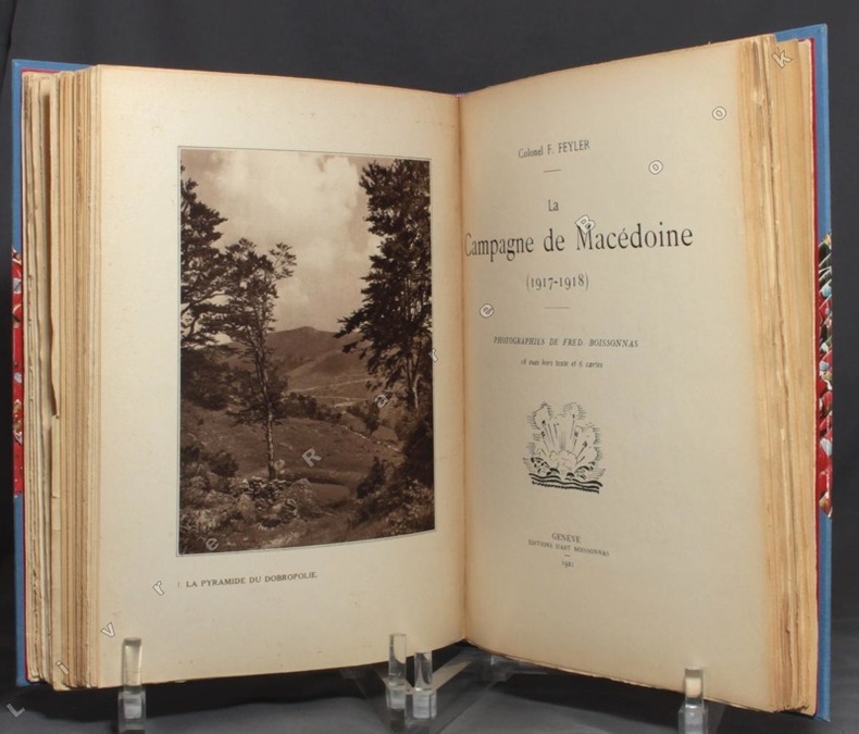
19209490Genève et Paris, Editions d'Art Fred Boissonnas et Librairie Jean Budry, 1920-1921. 3 ouvrages en un volume in-4 de [6]-133-[10]; [8]-118-[4]; [8]-122-[4] pages, demi-toile bleue à coins, titre doré au dos, chacun des trois volumes comportant les couvertures rempliées, illustrées en 2 tons, conservées.
Very Good Turkish, Ottoman (1500-1928) Original color map. Folded. Oblong atlas folio. (50 x 60 cm). In Ottoman script. Shows Rhodes and Tilos Islands. Scale: 1/200.000. Hegira: 1332 = Gregorian: 1916. Not description on map-maker. This is one of the series of the Bonn projection maps which are the first map series in modern techniques in Turkey and the Ottoman Empire. This is one of the series of the Bonn projection maps which are the first map series in modern techniques in Turkey and the Ottoman Empire. In order to produce these maps covering Turkish territory, Reconnaissance Branch was incorporated into The Mapping Commission. The maps were produced in the datum based on the latitude and longitude of Ayasofya Mosque in an equal area Bonn Projection. The field works for the 123 sheets covering the country were conducted by 76 staff. The production was completed in 18 years starting from east-west. Fieldworks continued without stopping except in the years 1914 and 1920. This map series called also reconnaissance maps contributed a lot to producing 1:25.000 scale maps. A very detailed and attractive map of Rhodes Island showing its harbors and Ottoman place names.
Features: The "Hold-Up" at Fenelon; Avalances; A Tramp in Spain - VI; Hunting the Giant Tortoise; A Desert Tragedy; The Land of the Shrimp-God; How "Buffalo Bill" Won his Name; The Looting of the "Bang Yee"; On the March in the Bahr-El-Ghazal - III; Francisca Machalek, the female burglar; The Wilson Life Insurance Fraud; "Monkey"; The Happenings of a Night; A West African Mutiny; Paris to New York Overland - IV; A Chapter of Mishaps; My Experiences at Kano - I; Besieged in a Tree; The Man-Stealers; In the Grip of the Quagmire; The Monks' Republic; The Strange Case of the "Ferret"; The Calculut Affair; Some Japanese Signboards; A Tramp in Spain - VII; Hoist By His Own Petard; The Island of Captive Kings; The March of "Coxey's Army"; Sport and Adventure in Gallaland - I; In the Land of the "Never-Never"; The Range War; A Thousand Miles in a Refrigerator; Sport and Adventure in Gallaland - II; How the Treasure was Saved; A Tardy Vindication; Rambles in Macedonia; Attacked by Wolves in the Desert; A Tramp in Spain - VIII; My Experiences at Kano - II; Defective in the Barrel; The Last of the Bushrangers; Prisons of Many Lands; The Solving of a Mystery; "Meistertrunk" at Rothenburg; The Shrine by the Nujha Bridge; Among the Buriats; Adrift on a Raft; A Night of Horrors; The Narcissus Festival at Montreux; A Mountain of Salt; After the "Mad Mullah"; A Unique Summer Residence; The Wandering Jew; With the British to Sokoto; John Glover of Texas; A Baby Parade; How the Gipsy Queen found her lover; A Cargo of Cats; A Tramp in Spain; When the Water Came Down; A Mystery of the Bush; The Story of My Chinese God; A Battle with a Rhino; After the "Mad Mullah" - II; The Pursuit of Captain Victor - II; The Cave-Dwellers of Mexoco; Calamity Jane; With the British to Sokoto - II; Arrested as Spies; When Niagara Ran Dry; The Flying Dutchman; Among the South Sea Cannibals - I; Across Sumatra in a Motor-Car; A Tramp in Spain - X; Our Attempt to Reach Mecca; A Puma Hunt in Surrey; Entombed in a Capsized Ship; With the British to Sokoto - II; The Apotheosis of Simpson; Our Quiet Little Shooting Trip; My Adventure with a Lunatic; A Tramp in Spain - XI; Sacred Town of Mandhata; Mystery of Silver Bow Valley; Among the South Sea Cannibals - II; A Night in a God-House; The Tragedy of the "Maria" and My Part in it; The Red Pig of Poora; Two-Thousand Miles in a Trawler; The Most Inaccessible Place in China; What Happened at Morelia; The Blumencorso at Hamburg. Heavily worn. Backstrip almost detached. Binding open after second blank leaf. A worthy reading copy. Book
Very Good French Original decorated map. Hand-coloured. Oblong elephant folio. (54 x 76 cm). In French. Shows Greece, Archipelago, Isle de Candie, Asia Minor (Western side), and East Mediterranean. Delisle od de l'Isle was a French cartographer known for his popular and accurate maps of Europe and the newly explored Americas. At 27, Delisle was admitted into the French Académie Royale des Sciences, an institution financed by the French state. After that date, he signed his maps with the title of "Géographe de l'Académie". Five years later, he moved to the Quai de l'Horloge in Paris, a true publishing hub where his business prospered. Delisle's progress culminated in 1718 when he received the title of Premier Géographe du Roi. He was appointed to teach geography to the Dauphin, King Louis XIV's son, a task for which he received a salary. Again, his father's reputation as a man of science probably helped the younger Delisle. Historian Mary Sponberg Pedley says, 'once authority was established, a geographer's name might retain enough value to support two or three generations of mapmakers'. Delisle's case, it could be said that his accomplishments surpassed his father's. Up to that point, he had drawn maps not only of European countries, such as Italy, Spain, Germany, Great Britain, Poland, and regions such as the Duchy of Burgundy, but he had also contributed to the empire's claims to recently explored continents of Africa and the Americas. Like many cartographers of his day, Delisle did not travel with the explorers. He drew maps mostly in his office, relying on a variety of data. The quality of his maps depended on a solid network to provide him first-hand information. Given his family's and his own reputation, Delisle had access to fairly recent accounts of travellers who were returning from the New World, which gave him an advantage over his competitors. Being a member of the Académie, he also kept current with recent discoveries, especially in astronomy and measurement. When he could not confirm the accuracy of a source, he would indicate it clearly on his maps. For instance, his Carte de la Louisiane shows a river that the baron of Lahontan claimed he discovered. As no one else could validate it, Delisle noted a warning to the viewer that it might not exist. (Source: Wikipedia). Tooley, p.43.
Very Good Turkish, Ottoman (1500-1928) Original color map on cloth. A little foxing on cloth. Very good. Folded. Oblong atlas folio. (66 x 72 cm). In Ottoman script. Scale: 1/210.000. Ottoman sanjaks in Albania and Greece. A rare Ottoman map of Balkans with Turkish place names for the period of pre-Balkan Wars, (1912-1913). Very important for onomastics and historical geography. Written 'Paris -French meridian- was accepted as the 0 meridian'. The Paris meridian is a meridian line running through the Paris Observatory in Paris, France-now longitude 2°20'14.03" east. It was a long-standing rival to the Greenwich meridian as the prime meridian of the world. Personal stamp of Muhiddin Pasha on cloth, under the printed descriptive texts. It's from the collection of him. Hasan Muhiddin Pasha [Çanga], (1866-1944), who was a lieutenant in Hedjaz Army of the Ottoman Empire in 1887. After he suppressed the rebellion in Yemen, 1891, his rank was promoted to the 'major'. After the Imam Yahya rebellion in Yemen, 1904, he prepared a report for the Ottoman government. He also took part in Ethiopia, Sudan, Yemen, Arabian Peninsula for various military duties. After promotion to division command, he was provincial president of CHP (Republican People's Party). He was a very important politic and diplomatic figure for the last period of Ottoman and early Republican Turkey. Not in Tooley. Extremely rare.
Very Good Turkish, Ottoman (1500-1928) Original color map on cloth. A little foxing on cloth. Very good. Folded. Oblong atlas folio. (66 x 72 cm). In Ottoman script. Scale: 1/210.000. Ottoman cities in Bulgaria. A rare Ottoman map of Balkans with Turkish place names for the period of pre-Balkan Wars, (1912-1913). Very important for onomastics and historical geography. Written 'Paris -French meridian- was accepted as the 0 meridian'. The Paris meridian is a meridian line running through the Paris Observatory in Paris, France-now longitude 2°20'14.03" east. It was a long-standing rival to the Greenwich meridian as the prime meridian of the world. Personal stamp of Muhiddin Pasha on cloth, under the printed descriptive texts. It's from the collection of him. Hasan Muhiddin Pasha [Çanga], (1866-1944), who was a lieutenant in Hedjaz Army of the Ottoman Empire in 1887. After he suppressed the rebellion in Yemen, 1891, his rank was promoted to the 'major'. After the Imam Yahya rebellion in Yemen, 1904, he prepared a report for the Ottoman government. He also took part in Ethiopia, Sudan, Yemen, Arabian Peninsula for various military duties. After promotion to division command, he was provincial president of CHP (Republican People's Party). He was a very important politic and diplomatic figure for the last period of Ottoman and early Republican Turkey. Not in Tooley. Extremely rare.
Very Good Turkish, Ottoman (1500-1928) Original color map on cloth. A little foxing on cloth. Very good. Folded. Oblong atlas folio. (66 x 72 cm). In Ottoman script. Scale: 1/210.000. Ottoman sanjaks in Greece, mostly in Greek Macedonia. A rare Ottoman map of Balkans with Turkish place names for the period of pre-Balkan Wars, (1912-1913). Very important for onomastics and historical geography. Written 'Paris -French meridian- was accepted as the 0 meridian'. The Paris meridian is a meridian line running through the Paris Observatory in Paris, France-now longitude 2°20'14.03" east. It was a long-standing rival to the Greenwich meridian as the prime meridian of the world. Personal stamp of Muhiddin Pasha on cloth, under the printed descriptive texts. It's from the collection of him. Hasan Muhiddin Pasha [Çanga], (1866-1944), who was a lieutenant in Hedjaz Army of the Ottoman Empire in 1887. After he suppressed the rebellion in Yemen, 1891, his rank was promoted to the 'major'. After the Imam Yahya rebellion in Yemen, 1904, he prepared a report for the Ottoman government. He also took part in Ethiopia, Sudan, Yemen, Arabian Peninsula for various military duties. After promotion to division command, he was provincial president of CHP (Republican People's Party). He was a very important politic and diplomatic figure for the last period of Ottoman and early Republican Turkey. Not in Tooley. Extremely rare.
Very Good Turkish, Ottoman (1500-1928) Original color map on cloth. A little foxing on cloth. Very good. Folded. Oblong atlas folio. (66 x 72 cm). In Ottoman script. Scale: 1/210.000. Ottoman sanjaks in Greece, mostly in Greek Macedonia. A rare Ottoman map of Balkans with Turkish place names for the period of pre-Balkan Wars, (1912-1913). Very important for onomastics and historical geography. Written 'Paris -French meridian- was accepted as the 0 meridian'. The Paris meridian is a meridian line running through the Paris Observatory in Paris, France-now longitude 2°20'14.03" east. It was a long-standing rival to the Greenwich meridian as the prime meridian of the world. Personal stamp of Muhiddin Pasha on cloth, under the printed descriptive texts. It's from the collection of him. Hasan Muhiddin Pasha [Çanga], (1866-1944), who was a lieutenant in Hedjaz Army of the Ottoman Empire in 1887. After he suppressed the rebellion in Yemen, 1891, his rank was promoted to the 'major'. After the Imam Yahya rebellion in Yemen, 1904, he prepared a report for the Ottoman government. He also took part in Ethiopia, Sudan, Yemen, Arabian Peninsula for various military duties. After promotion to division command, he was provincial president of CHP (Republican People's Party). He was a very important politic and diplomatic figure for the last period of Ottoman and early Republican Turkey. Not in Tooley. Extremely rare.
Very Good Turkish, Ottoman (1500-1928) Original color map on cloth. A little foxing on cloth. Very good. Folded. Oblong atlas folio. (66 x 72 cm). In Ottoman script. Scale: 1/210.000. Ottoman sanjaks in Greece, mostly in Thessaly. A rare Ottoman map of Balkans with Turkish place names for the period of pre-Balkan Wars, (1912-1913). Very important for onomastics and historical geography. Written 'Paris -French meridian- was accepted as the 0 meridian'. The Paris meridian is a meridian line running through the Paris Observatory in Paris, France-now longitude 2°20'14.03" east. It was a long-standing rival to the Greenwich meridian as the prime meridian of the world. Personal stamp of Muhiddin Pasha on cloth, under the printed descriptive texts. It's from the collection of him. Hasan Muhiddin Pasha [Çanga], (1866-1944), who was a lieutenant in Hedjaz Army of the Ottoman Empire in 1887. After he suppressed the rebellion in Yemen, 1891, his rank was promoted to the 'major'. After the Imam Yahya rebellion in Yemen, 1904, he prepared a report for the Ottoman government. He also took part in Ethiopia, Sudan, Yemen, Arabian Peninsula for various military duties. After promotion to division command, he was provincial president of CHP (Republican People's Party). He was a very important politic and diplomatic figure for the last period of Ottoman and early Republican Turkey. Not in Tooley. Extremely rare.
Very Good Turkish, Ottoman (1500-1928) Original color map on cloth. A little foxing on cloth. Very good. Folded. Oblong atlas folio. (66 x 72 cm). In Ottoman script. Scale: 1/210.000. Ottoman sanjaks in Greece, mostly in Thessaly. A rare Ottoman map of Balkans with Turkish place names for the period of pre-Balkan Wars, (1912-1913). Very important for onomastics and historical geography. Written 'Paris -French meridian- was accepted as the 0 meridian'. The Paris meridian is a meridian line running through the Paris Observatory in Paris, France-now longitude 2°20'14.03" east. It was a long-standing rival to the Greenwich meridian as the prime meridian of the world. Personal stamp of Muhiddin Pasha on cloth, under the printed descriptive texts. It's from the collection of him. Hasan Muhiddin Pasha [Çanga], (1866-1944), who was a lieutenant in Hedjaz Army of the Ottoman Empire in 1887. After he suppressed the rebellion in Yemen, 1891, his rank was promoted to the 'major'. After the Imam Yahya rebellion in Yemen, 1904, he prepared a report for the Ottoman government. He also took part in Ethiopia, Sudan, Yemen, Arabian Peninsula for various military duties. After promotion to division command, he was provincial president of CHP (Republican People's Party). He was a very important politic and diplomatic figure for the last period of Ottoman and early Republican Turkey. Not in Tooley. Extremely rare.
Very Good Turkish, Ottoman (1500-1928) Original color map on cloth. A little foxing on cloth. Very good. Folded. Oblong atlas folio. (66 x 72 cm). In Ottoman script. Scale: 1/210.000. Ottoman sanjaks in Greece. A rare Ottoman map of Balkans with Turkish place names for the period of pre-Balkan Wars, (1912-1913). Very important for onomastics and historical geography. Written 'Paris -French meridian- was accepted as the 0 meridian'. The Paris meridian is a meridian line running through the Paris Observatory in Paris, France-now longitude 2°20'14.03" east. It was a long-standing rival to the Greenwich meridian as the prime meridian of the world. Personal stamp of Muhiddin Pasha on cloth, under the printed descriptive texts. It's from the collection of him. Hasan Muhiddin Pasha [Çanga], (1866-1944), who was a lieutenant in Hedjaz Army of the Ottoman Empire in 1887. After he suppressed the rebellion in Yemen, 1891, his rank was promoted to the 'major'. After the Imam Yahya rebellion in Yemen, 1904, he prepared a report for the Ottoman government. He also took part in Ethiopia, Sudan, Yemen, Arabian Peninsula for various military duties. After promotion to division command, he was provincial president of CHP (Republican People's Party). He was a very important politic and diplomatic figure for the last period of Ottoman and early Republican Turkey. Not in Tooley. Extremely rare.
Very Good Turkish, Ottoman (1500-1928) Original color map on cloth. A little foxing on cloth. Very good. Folded. Oblong atlas folio. (66 x 72 cm). In Ottoman script. Scale: 1/210.000. Ottoman sanjaks in Greece. A rare Ottoman map of Balkans with Turkish place names for the period of pre-Balkan Wars, (1912-1913). Very important for onomastics and historical geography. Written 'Paris -French meridian- was accepted as the 0 meridian'. The Paris meridian is a meridian line running through the Paris Observatory in Paris, France-now longitude 2°20'14.03" east. It was a long-standing rival to the Greenwich meridian as the prime meridian of the world. Personal stamp of Muhiddin Pasha on cloth, under the printed descriptive texts. It's from the collection of him. Hasan Muhiddin Pasha [Çanga], (1866-1944), who was a lieutenant in Hedjaz Army of the Ottoman Empire in 1887. After he suppressed the rebellion in Yemen, 1891, his rank was promoted to the 'major'. After the Imam Yahya rebellion in Yemen, 1904, he prepared a report for the Ottoman government. He also took part in Ethiopia, Sudan, Yemen, Arabian Peninsula for various military duties. After promotion to division command, he was provincial president of CHP (Republican People's Party). He was a very important politic and diplomatic figure for the last period of Ottoman and early Republican Turkey. Not in Tooley. Extremely rare.
Very Good Turkish, Ottoman (1500-1928) Original color map on cloth. A little foxing on cloth. Very good. Folded. Oblong atlas folio. (66 x 72 cm). In Ottoman script. Scale: 1/210.000. Ottoman sanjaks in Greece, mostly in Thessaly and Macedonian Greece. A rare Ottoman map of Balkans with Turkish place names for the period of pre-Balkan Wars, (1912-1913). Very important for onomastics and historical geography. Written 'Paris -French meridian- was accepted as the 0 meridian'. The Paris meridian is a meridian line running through the Paris Observatory in Paris, France-now longitude 2°20'14.03" east. It was a long-standing rival to the Greenwich meridian as the prime meridian of the world. Personal stamp of Muhiddin Pasha on cloth, under the printed descriptive texts. It's from the collection of him. Hasan Muhiddin Pasha [Çanga], (1866-1944), who was a lieutenant in Hedjaz Army of the Ottoman Empire in 1887. After he suppressed the rebellion in Yemen, 1891, his rank was promoted to the 'major'. After the Imam Yahya rebellion in Yemen, 1904, he prepared a report for the Ottoman government. He also took part in Ethiopia, Sudan, Yemen, Arabian Peninsula for various military duties. After promotion to division command, he was provincial president of CHP (Republican People's Party). He was a very important politic and diplomatic figure for the last period of Ottoman and early Republican Turkey. Not in Tooley. Extremely rare.
Very Good Turkish, Ottoman (1500-1928) Original color map on cloth. A little foxing on cloth. Very good. Folded. Oblong atlas folio. (66 x 72 cm). In Ottoman script. Scale: 1/210.000. Ottoman sanjaks in Balkans. A rare Ottoman map of Balkans with Turkish place names for the period of pre-Balkan Wars, (1912-1913). Very important for onomastics and historical geography. Written 'Paris -French meridian- was accepted as the 0 meridian'. The Paris meridian is a meridian line running through the Paris Observatory in Paris, France-now longitude 2°20'14.03" east. It was a long-standing rival to the Greenwich meridian as the prime meridian of the world. Personal stamp of Muhiddin Pasha on cloth, under the printed descriptive texts. It's from the collection of him. Hasan Muhiddin Pasha [Çanga], (1866-1944), who was a lieutenant in Hedjaz Army of the Ottoman Empire in 1887. After he suppressed the rebellion in Yemen, 1891, his rank was promoted to the 'major'. After the Imam Yahya rebellion in Yemen, 1904, he prepared a report for the Ottoman government. He also took part in Ethiopia, Sudan, Yemen, Arabian Peninsula for various military duties. After promotion to division command, he was provincial president of CHP (Republican People's Party). He was a very important politic and diplomatic figure for the last period of Ottoman and early Republican Turkey. Not in Tooley. Extremely rare.
Very Good Turkish, Ottoman (1500-1928) Original color map on cloth. A little foxing on cloth. Very good. Folded. Oblong atlas folio. (66 x 72 cm). In Ottoman script. Scale: 1/210.000. Ottoman sanjaks in Albania, Macedonia, Greece and Serbia. A rare Ottoman map of Balkans with Turkish place names for the period of pre-Balkan Wars, (1912-1913). Very important for onomastics and historical geography. Written 'Paris -French meridian- was accepted as the 0 meridian'. The Paris meridian is a meridian line running through the Paris Observatory in Paris, France-now longitude 2°20'14.03" east. It was a long-standing rival to the Greenwich meridian as the prime meridian of the world. Personal stamp of Muhiddin Pasha on cloth, under the printed descriptive texts. It's from the collection of him. Hasan Muhiddin Pasha [Çanga], (1866-1944), who was a lieutenant in Hedjaz Army of the Ottoman Empire in 1887. After he suppressed the rebellion in Yemen, 1891, his rank was promoted to the 'major'. After the Imam Yahya rebellion in Yemen, 1904, he prepared a report for the Ottoman government. He also took part in Ethiopia, Sudan, Yemen, Arabian Peninsula for various military duties. After promotion to division command, he was provincial president of CHP (Republican People's Party). He was a very important politic and diplomatic figure for the last period of Ottoman and early Republican Turkey. Not in Tooley. Extremely rare.