VITRUVELivre Rare Book
1 783 résultats
1673116729Coignard 1673 in-folio A Paris, Chez Jean-Baptiste Coignard, 1673, in-folio à grandes marges de 285x420 mm environ, (2) ff., 1 frontispice, page de titre, (8) ff. (Epistre, Préface), 325 pages, (7) ff. (Table), (1) f. (Privilège), (3) ff. Pleine reliure granitée d'époque, dos à 6 nerfs, titres dorés, caissons ornés, roulette dorée sur les coupes, tranches mouchetées. Reliure restaurée, ors passés, restauration de la page de titre, importantes traces de mouillures marginales sur les 4 feuillets liminaires puis petites auréoles marginales et éparses au long du volume, légères déchirures sans atteinte au texte sur 2 feuillets, pagination fantaisiste à partir de la page 238 (sans manque). Bel exemplaire malgré les défauts signalés, intérieur très frais.
17624595London: Printed By John Haberkorn for the Authors 1762. First edition. Hardcover. Good. Folio unpaginated vintage marbled boards rebacked with corners of canvas new endpapers; Lacks plates 21 & 22 in chapter 4 showing Bacchan pirates turned into dolphins some mostly marginal bookworm tracks; Errata leaf bound in place long vertical tear in the last folding plate. Rare. <br/><br/>This is vol. 1 only: Subsequent volumes appeared into the early 1800s. Fowler 340 . "After their return to London in 1755 Stuart worked on the first volume of Antiquities of Athens which was published in 1762. He wrote and revised the text had the illustrations engraved and designed a binding as well as painting views of Greece and Pola in gouache for exhibition. The first volume contained details of just five buildings in the northern part of Athens but more were promised in further volumes. The first volume had more than 500 subscribers. Few were architects or builders which limited the impact of the work as a design sourcebook. It was however well received by scholars antiquaries and gentleman amateurs. The presentation binding that Stuart designed for Antiquities of Athens had a Neo-Classical design and inspired architect Robert Adam to design similar presentation bindings for his work on the antiquities of Spalatro. Antiquities of Athens helped shape the European understanding of ancient Greece. It brought an entirely new design vocabulary to 18th-century European architecture and design and later became an essential sourcebook for the 19th-century Greek Revival - V&A exhibit on Stuart in 2007." Most of these engravings were engraved by James Basire who ten years later taught engraving to William Blake. I count 78 engravings including head and tail-pieces and two folding plates. A few plates were executed by Edward Rooker who was celebrated for his architectural plates. Printed By John Haberkorn for the Authors hardcover
In-folio, 57 ll., 1bl.; engraved title and 51 full-page engraved plates, giving geodetic and cosmographic instruments and measurements; woodcut ornate initials and tailpieces, large Aldus anchor woodcut device at the end. Bound in contemporary cartonnage (reliure d'attente), with weak hinges; occasional light foxing, light dampstain at the bottom of the last leaves. Despite the title the work includes 50 full-page engravings, of which the last 7 are a supplement by Scala and are especially devoted to architecture and perspective.
Very Good Turkish, Ottoman (1500-1928) Original manuscript autograph handwritten document sealed 'Hüsrev Mehmed' sent to (and responded by) Serkâtib Mustafa. Written in special paper with 'ahar'. 39x21 cm. In Ottoman script. Slightly tear on folded place and slightly stains. Otherwise a very good manuscript paper. The document was written in accordance with the Ottoman state correspondence tradition prior to modernization. However, it is an indication of modernization that it is written to the serkâtib of Humâyûn (head clerk of the Ottoman / Turkish court) and not to the Sultan directly. The importance of this document is that it has many hints of modernization movements of the last period of Empire, depiction of the division of the first modern Ottoman army (Asakir-i Mansure-i Muhammediye) that's before one year of Egyptian Campaign by Koca Husrev Pasha and before eight years of proclamation of Reform (Tanzimat) and after only 22 years of Turkish Magna Carta (Sened-i Ittifak). Husrev Pasha was 'serasker' (commandant and head) of Assakir-i Mansure-i Muhammediye Army in that year. Husrev's text starts as 'Devletlü, inayetlü, atufetlü, oglum.." in 'Elqab'. In the Ottoman diplomacy, first person who used 'oglum' [i.e. my son] in elqab of the documents was Koca Hüsrev Pasha. (Source: Osmanli Arsiv Belgeleri, Orhan Sakin). Koca Hüsrev Pasha (Khosrew Pasha) was an Ottoman Kapudan Pasha ("Grand Admiral") of the Ottoman Navy and statesman who reached the position of Grand Vizier rather late in his career, between 2 July 1839 and 8 June 1840 in the reign of Abdülmecid I. However, during the 1820s, he occupied key administrative roles in the fight against regional warlords, the reformation of the army, and the reformation of Turkish attire. In 1801, Hüsrev Pasha commanded the 6,000 Ottoman troops who assisted the British in removing the French from Rashid (Rosetta). For this, he was made governor of Egypt Eyalet (province), in which position he was charged with assisting Hüseyin Pasha in the killing or imprisoning the surviving leaders of the Mamluks. Many of these were freed by or fled with the British, while others held Minia between Upper and Lower Egypt. [.] He was later made governor again by Muhammad Ali for 2 days [.] After Diyarbekir and Salonica, in 1806 he was governor of Bosnia Eyalet, before being reappointed as governor of Salonica in 1808. Hüsrev Pasha held the rank of Kapudan Pasha of the Ottoman Navy from 1811 to 1818. He was then appointed governor of the Eyalet of Trabzon twice, during which time he conducted for the Black Sea region of Turkey the struggle the central Ottoman state was waging against local feudal rulers (Derebeys). During the Greek War of Independence, he was appointed Kapudan Pasha again in the end of 1822. In 1826, Husrev Pasha played vital roles both in the Auspicious Incident (the annihilation of the Janissary Corps in 1826) and in the formation of the new "Mansure Army" modeled after those of European Powers. Appointed as seraskier (commander the army) of the Mansure in May 1827, Husrev reformed and disciplined the corps. Himself ignorant of modern military methods, he assembled a staff of foreign experts and other personnel to assist him, the "Seraskeriye", which constituted the first staff in Ottoman history. Due to his early championing of military reform and virtual control over the new Ottoman army, Husrev was able to install many of his protégés in senior military positions. Husrev Pasha was also instrumental for the near-abandonment of the turban and the adoption of the fez as a universal headgear for Muslim men of the Ottoman Empire (excluding the religious classes) under Sultan Mahmud II. (Wikipedia). Möltke talks about him in famous book includes his personal letters as 'he is more powerful than sultan'. Following the suppression of the Janissaries in 1826, Sultan Mahmud II transferred the functions of the old Agha of the Janissaries to the seraskier.
18800267-05[ca. 1880]. [Album of views in Egypt]. 40 lose Orig.-Albumen-Photographien auf Kartons kasch. 21,5 x 27,5 cm. (Plattengr.). Ln.-Flügelmappe d. Zt. m. Deckelgoldprägung.
68080, Taschen, 1995 Limited Art Edition of 100 copies worldwide, clothbound in a clamshell box, SIGNED by Richard Meier in 1996, accompanied by a silk-screen print. Hardcover in clamshell box, 22.5 x 30 cm, 1.91 kg, 176 pages, Multilingual (English, French, German).
1771144411771 un volume, reliure plein veau brun raciné (reliure de l'époque) in-quarto (binding full calfskin in-quarto), dos à nerfs (spine with raised bands), décoration or (gilt decoration) à filets or (gilt lines) et à froid (blind-stamping decoration) - entre-nerfs à fleuron au fer plein (between the raised bands floweret with full blocking stamp) - compartiments à fleurons (compartment with floweret) - titre frappé or (gilt title) - pièce de titre sur fond bordeaux (label of title) avec filet or (label of title with gilt line) - légèrement manquante dans la partie supérieure mais trés léger (it misses a little of the label of title) - dos légèrement frotté avec léger manque de dorure (blurred gilding) , plats avec de légères épidermures (front cover with light scratches) - plats muets (cover without text), coins émoussés (corners blunt) écornés (corners dog-eared), filet sur les coupes (gilt line on the cuts) manque de dorure (blurred gilding), marque-page en tissu (bookmark in tissue), tête lisse (top edge smooth), toutes tranches lisses (all smooth edges) rouges (all red edges) avec une tache d'encre sur la tranche de tête, texte à manchette (marginal note), sans illustration (no illustration) excepté vignettes de titre aux armes royales (certaines légèrement hachurées à l'encre brune ou recouverte d'un lavis bleu-blanc-rouge "Révolution Oblige" (title page decorated with a vignette of title) gravées sur bois en noir + et orné de bandeaux - lettrines et de culs-de-lampe (illuminated of headpieces and dropped initials and of tailpieces) gravées sur bois en noir, Quelques rares trous de vers mais n'atteignant pas le texte, XIII, 344, 7, 11, 8, 27, 12, 14 pp. + 48 pages de table des matières pour ORDONNANCE DU ROI, CONCERNANT LA MARINE DU 25 MARS 1765 + Règlement concernant les Etats-Majors et Equipages dont les Vaisseaux et autres Bâtiments du Roi seront armés; ensemble les Appointements et Soldes et ceux qui doivent les composer (Brest Malassis 1768) 22 pages + Règlement contenant les Canons, les Armes et les Ustensiles et Munitions qui en dépendent, pour l'Armement de Vaisseaux et autre Bâtiments du Roi (-52 pages- Imprimerie Royale 25 mars 1765) + Règlements contenant les Aménagemens qui seront à l'Avenir pratiqués dans les Vaisseaux et autres Bâtiments du Roi; ensemble les Agrès, Ustensiles et Munitions pour leur Armement et Equipement en Tems de Guerre et en Tems de Paix, pour six mois de Campagne (Brest Malassis 1766 - 188 pages) + Ordonnance du roi concernant la Régie et Administration Générale et Particulière des Ports et Arsenaux de Marine du 27 septembre 1776 (Paris Imprimerie Royale 1776 - 160 pages) + Ordonnance du Roi pour régler les Fonctions dont les Officiers de la Marine seront chargés sur les Escadres et à Bord des Vaisseaux, relativement aux consommations et remplacements des Munitions et des Effets, et aux Revues des Equipages dans le cours des Campagnes du 27 septembre 1776 (Paris Imprimerie Royale 1776-23 pages-) (dont Ordonnance du Roi pour donner le Rang de Lieutenant-Colonel aux cinquante plus anciens Lieutenans de Vaisseaux du 10 mai 1777 - 2 pages- de l'imprimerie royale 1777- intercalée entre la page 10 et 11) + Ordonnance du Roi concernant les Officiers de Port du 27 septembre 1776 (4 pages- Paris Imprimerie Royale 1776) + Ordonnance du Roi portant réglement sur les Pavillons et Marques de Commandement que les Vaisseauxl porteront à la mer du 19 novembre 1776 (Paris Imprimerie Royale -12 pages) + Ordonnance du Roi pour la suppression du Corps des Officiers d'Administration et des Ecrivains de la Marine du 27 septembre 1776 (4 pages- Paris imprimerie Royale 1776) + Ordonnance du Roi portant établissement des Commissaires Généraux et Ordinaires des Ports et Arsenaux de Marine, et de Gardes-Magasins du 27 septembre 1776 (8 pages - Paris Imprimerie Royale 1776) + Ordonnance du Roi portant établissement de Commissaires et de Syndics des Classes du 27 septembre 1776 (4 pages- Paris Imprimerie Royale 1776) + Ordonnance du Roi portant établissement de Controleurs de la Marine du 27 septembre 1776 (4 pages- paris imprimerie royale 1776) , 1765- 1776 Paris Imprimerie Royale + Brest Malassis Editeur,
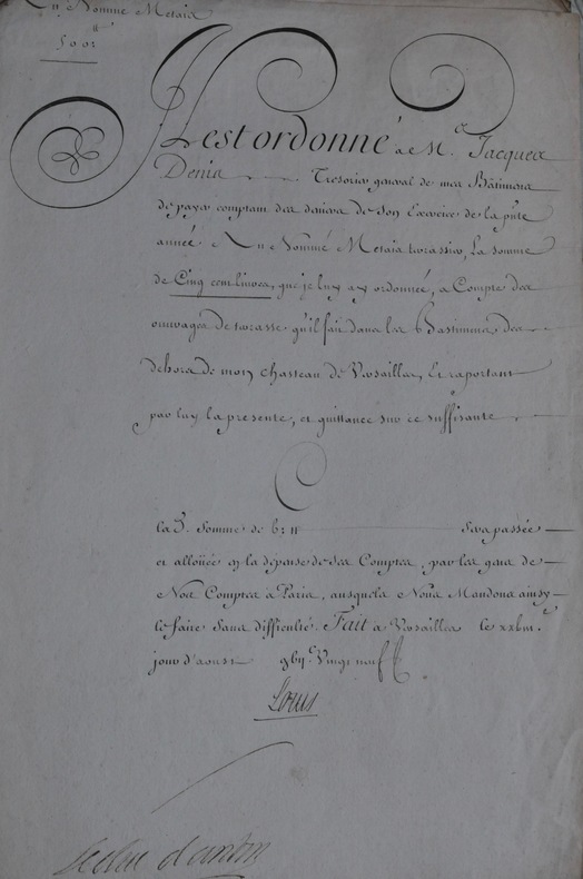
172946405273, 1729-1733 ; 6 pp. sur 6 ff. in-folio, 6 pièces calligraphiées, signées par le roi et par le directeur des bâtiments royaux. 5 sont des ordres de payement pour des travaux effectués dans les châteaux et autres possessions royales à Versailles, Marly, Saint-Germain, Compiègne et Fontainebleau, le sixième concerne la passation de la charge de trésorier des bâtiments royaux de M. Denis, à M. Guenebault.1) du 28 août 1729. “Il est ordonné à M. Jacques Denis trésorier général des Bâtiments de payer comptant (...) au nommé Metaier terrassier, la somme de cinq cent livres (...) à compte des ouvrages de terrasse qu’il fait dans les bâtiments du dehors de mon château de Versailles...”2) du 10 oct. 1729. “Il est ordonné à M. Jacques Denis trésorier général des Bâtiments de payer comptant (...) au nommé Denibicq menuisier la somme de deux mille sept cent cinquante livres (...) réparations de menuiseries (...) de Marly qu’à celui de Saint-Germain...”3) du 2 nov. 1729. “Il est ordonné à M. Jacques Denis trésorier général des Bâtiments de payer comptant (...) à Michel Godard terrassier la somme quinze cent livres (...) à compte de labourer & défrichement de terres qu’il sait dans mes pépinières et avancées de mes maisons royales (...)”4) le 8 août 1730. “Il est ordonné à M. Jean-Baptiste Guenebault commis par arrêt de mon conseil pour achever l’exercice de feu M. Jacques Denis trésorier général de mes bâtiments de payer comptant des deniers de son exercice de l’année dernière aux arpenteurs et dessinateurs qui ont esté employés sous la conduite du Sr. Matis géographe et arpenteur de mesdits bâtim. à dessiner les nouvelles cartes de ma forest de Compiègne la somme de cinq cent dix livres (...) pour son payement de leurs journées et des menues dépenses à ce sujet (...)”5) le 20 mars 1731. “Il est ordonné à M. Jean-Baptiste Guenebault commis par arrêt de mon conseil (...) à Simon Couturier terrassier la somme de deux cent soixt huit livres six sols huit deniers (...) des ouvrages de convoy et terrasse (...) aux pièces d’eau et bassins du jardin de mon château de Fontainebleau (...)”6) du 6 mars 1733. “Il est ordonné à M. Jean-Baptiste Guenebault commis par arrêt de mon conseil (...) de remettre comptant des deniers de l’exercice 1729 à M. Jean-François Denis trésorier général de mes bâtiments la somme de seize mille trois cent livres restant en ses mains faisant partie de son dernier exercice 1729 (...)”
2015114722Images Publishing Dist Ac. New. 2015. Hardcover. 1864706511 . FREE UPGRADE to Courier/Priority Shipping Upon Request - IN STOCK AND IMMEDIATELY AVAILABLE FOR SHIPMENT - IN STOCK AND IMMEDIATELY AVAILABLE FOR SHIPMENT - Flawless copy brand new pristine never opened - -- with a bonus offer-- . Images Publishing Dist Ac hardcover
Very Good Turkish, Ottoman (1500-1928) Extremely rare huge chromo-lithograph map in 24 sheets mounted on canvas, showing a large zone including Midyat (Mardin), Mosul, Mt. Cilo (Resko-Buzul) on the southeast; Kahta (Adiyaman), Munzur Mt., Divrigi (Sivas) on the west; the Black Sea on north and Turkish borders to Armenia, Azerbaijan on the east, and to Russia on the northeast. In addition shows in separate little portions, roads, mountains and hills, lakes, and telegraph and post ways and borders in that zone. Not in any libraries and any collection. An attractive map with its huge size and decorative surface. Several toponyms are underlined in red ink. Otherwise a very good example. Original folded map mounted on canvas. 118x112 cm. In Ottoman script (Turkish with Arabic letters). Scale: 1/630.000.
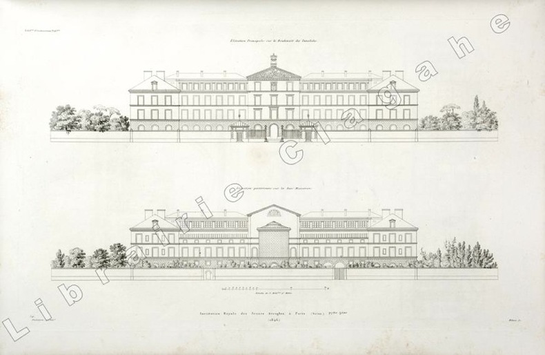
184619809(Paris, 1846) ; in folio, toile vert foncé, double encadrement de filets dorés maigre et gras, tranches dorées, titre doré en long ; papier de garde multicolore peigné (reliure de l’époque); [4], 6 planches gravées de plans des bâtiments et des jardins situés au N°56 du boulevard des Invalides à Paris.
Very Good Turkish, Ottoman (1500-1928) An extremely rare litho propaganda map published as an extra supplement to the Tercümân-i Hakîkat [i.e. The Translator of Truth] newspaper just before the proclamation of Republic in Turkey in 1923 by Mustafa Kemal Atatürk (1881-1938), showing the front in West Anatolia during the War of Independence (or National Struggle) between 1919-1922 against Greek forces. The upside of the map between the note as title 'Gift to the readers of 'Tercümân-i Hakîkat', Mustafa Kemal Atatürk's portrait among decorated heroic lithographed drawings. In the lower right corner, can be seen legends of the map, scale, and mapmaker's signature. Tercümân-i Hakîkat was a daily newspaper published in Istanbul between 1878-1921 during the Ottoman Empire. Tercüman-i Hakîkat, the most important newspaper published during the reign of Sultan Abdülhamid II, was founded by novelist Ahmed Midhat Efendi, (1844-1912). In the beginning, most of the articles were written by Ahmed Midhat Efendi. It was an encyclopedic newspaper with the aim of inculcating and educating reading habits among the Turks and it played an important role in the training of many famous Ottoman journalists. Its first issue was published on June 26, 1878. After Ahmed Midhat's death in 1913, the newspaper changed owners, and the last issue was published on February 11, 1921. Ibrahim Alaettin Gövsa, (1889-1949), was an Ottoman / Turkish journalist, educator, and intellectual who supported the War of Independence the most. This propaganda map published in Tercümân-i Hakîkat, during the war in 1920 or 1921, is a propaganda tool that calls on the literate people belonging to a certain class, especially those living in Istanbul, to support the war, and aims to spread the word that Turkey is winning the war. Original lithograph map. 50x35,5 cm. In Ottoman script (Turkish with Arabic letters). Scale: 1: 250.000. Occasionally foxing and slight stains on paper, folded traces. Otherwise a very good copy.
18203657Couverture rigide Etablissement lithographique du Comte de Lasteyrie 1820 Paris 29,5x22,5 cm
185448328Zürich, Meyer und Zeller, (1854-) 1879. 4to. Contemporary halfcalf. Gilt spine, gilt letterinf. Fronthinge weakening. 1. Bericht (title without year): pp. (66-) 100 - 2.: pp. (110-) 155 - 3.: X,(73-) 116 - 4.: 34,(2) pp. - 5.: (4),(131-) 188 pp. - 6.: VIII,(245-) 320 pp. - 7.: (2),(4),69,(2),XII,(2) pp. - 8.: VIII,58 pp. and 85 lithographed plates, each with numerous illustr., 2 views (complete). Siebenter berich has 2 titlepages, the first: ""Résultat des Recherches exécutées dans les Lacs de la Suisse Occidentale depuis l'année 1866 decrit par V. Gross, F.-A. Forel et Edm. de Fellenberg"". The second: ""Pfahlbauten. Siebenter Bericht. Von Ferdinand Keller"". A few minor brownspots, internally clean.The work was published in ""Mittheilungen der antiquarischen Gesellschaft in Zürich"", Bde IX,,XII,,XIII,,XIV,.XV,,XIX, a. XX. The work has successively belong to three well-known Danish archaeologist: Georg Sarauw, Axel Steensberg and J. Troels-Smith with their names on front free endpaper.Troels-Smith is internatonally known as one of the pioneers in Pollen Analysis, especially with his work ""Pollenanalytische Untersuchungen zu einigen Schweizerischen Pfahlbauproblemen"" founded on his excavations on the ""Pfahlbauten"".
185448328Zürich Meyer und Zeller 1854- 1879. 4to. Contemporary halfcalf. Gilt spine gilt letterinf. Fronthinge weakening. 1. Bericht title without year: pp. 66- 100 - 2.: pp. 110- 155 - 3.: X73- 116 - 4.: 342 pp. - 5.: 4131- 188 pp. - 6.: VIII245- 320 pp. - 7.: 24692XII2 pp. - 8.: VIII58 pp. and 85 lithographed plates each with numerous illustr. 2 views complete. Siebenter berich has 2 titlepages the first: "Résultat des Recherches exécutées dans les Lacs de la Suisse Occidentale depuis l'année 1866 decrit par V. Gross F.-A. Forel et Edm. de Fellenberg". The second: "Pfahlbauten. Siebenter Bericht. Von Ferdinand Keller". A few minor brownspots internally clean.The work was published in "Mittheilungen der antiquarischen Gesellschaft in Zürich" Bde IXXIIXIIIXIV.XVXIX a. XX. The work has successively belong to three well-known Danish archaeologist: Georg Sarauw Axel Steensberg and J. Troels-Smith with their names on front free endpaper.Troels-Smith is internatonally known as one of the pioneers in Pollen Analysis especially with his work "Pollenanalytische Untersuchungen zu einigen Schweizerischen Pfahlbauproblemen" founded on his excavations on the "Pfahlbauten". <br/><br/><em>First edition of this pioneer work in Swiss archaeology exposing in a long series of reports his finds in the Swiss lakes the Swiss lake Dwellings - describing the Swiss "Urbevölkerung" with their Stake Buildings and the rich finds around these in the Swiss lakes. </em> unknown
176116534Lyon, J.M. Bruyset, 1761 ; in-8, veau fauve marbré, dos à nerfs décoré et doré, pièce de titre grenat, roulette sur les coupes (reliure d’époque) ; (4), XVI, 283 pp. grand plan dépliant (446 X 580 mm), dessiné et gravé par Jacquemin en 1747.
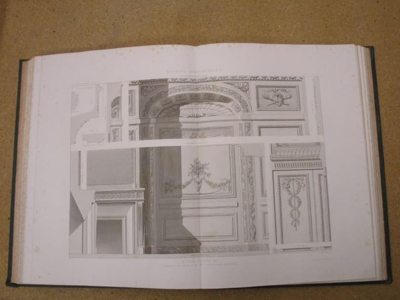
1869116154Morel 1869 Paris, se vend chez A. Morel, librairie-éditeur, Bibliothèque de l'Architecture (série des Etudes d'Architecture Historique), 4 volumes en demi-chagrin vert de deux teintes différentes selon la série à laquelle le volume appartient, environ 45x35 cm, 1869 (première série), 1880 (deuxième série). Première série :Tome I : 44 p.- 112 planches. Tome II : 85 planches (dont la 18 bis). Seconde série : Tome 1 : 3 p. - 105 planches. Tome 2 : 95 planches. Des frottements sur les reliures, des taches sur les plats, coins émoussés, des rousseurs. Bon état pour le reste.
Very Good Turkish, Ottoman (1500-1928) Contemporary red cloth. Roy. 8vo. (24 x 16 cm). In Ottoman script (Old Turkish with Arabic letters). [1], 229, [1] p., many b/w and color ills., 30 chromo-lithographed maps. Wear and fading on spine, some ex-library stamps on the colophon and several blank pages, ownership ink inscription and signature on the first page-overall a good copy. First edition of this rare Ottoman atlas for the primary schools in the late Ottoman Empire, including beautiful 30 chromo-lithographed maps of the Ottoman land according to administrative regions (provinces) and richly illustrated with b/w plates of the cities and provinces in the Middle East. Map list: 1. World map 2. Complete Imperial Ottoman 3. Arabian Peninsula 4. Anatolia 5. Asia Minor 6. Marmara and Black Sea 7. Aegean (The Archipelago) 8. Demography of Anatolia and Syria, Libya, etc 9. Administrative map of Anatolia 10. Map of mines of Anatolia 11. Agricultural map of the Imperial Ottoman 12. Arabian Peninsula 13. Map of the Edirne Vilayat [Adrianople Province of the Ottoman Empire] 14. Map of the Bosphorus 15. Map of the Hüdavendigâr Vilayat [Brusa Province] 16. Maps of Izmit and Biga Sanjaks 17. Map of Aydin Vilayat and Mentese Sanjak 18. Map of the Konya Vilayat 19. Maps of the Adana Vilayat and the Mediterranean Sea 20. Maps of the Erzurum and Ankara Vilayats 21. MAps of Kastamonu Vilayat and Bolu Sanjak 22. Map of the Trebizond Vilayat 23. Maps of the Van and Bitlis Vilayats 24. Maps of the Sivas and Harput Vilayats 25. Maps of the Bagdad and Basrah Vilayats 26. Map of the Mosul Vilayat and Day al-Zor Sanjak 27. Map of the Aleppo Vilayat and Urfa Sanjak 28. Map of the Syria and Beirut Vilayats 29. Map of the Arabia 30. Maps of the Yemen vilayat and Asir Sanjak. This atlas was printed four times for the different classes of the early Turkish / Ottoman schools, during World War 1 (two times in 1916) and the National Struggle (two times in 1921). Geylangil was born in Istanbul in 1887 and studied in Aleppo and Baghdad. Geylangil, who also studied economic geography, taught geography at many schools, including Galatasaray High School. Until his death, he wrote 14 books on geography, most of which were geographical atlases. In 1941, he was among the founding members of the Turkish Geographical Society. Özege 23216.; TBTK 11481.; We couldn't find any copy of this edition worldwide.
Very Good Turkish, Ottoman (1500-1928) Contemporary quarter leather bdg. Rebacked boards. Foolscap 8vo. (18 x 12 cm). In Ottoman script (Old Turkish with Arabic letters). 220 p. Very rare early book of the concise biographies of 137 people who served as admirals in the Ottoman Empire between 1352 and 1853, written by Mehmed Izzet Pasha (d. 1853), son of Turkish admiral Abdullah Râmiz Pasha (d. 1813). Ceridehâne Printing House was founded for publishing Ceride-i Havâdîs [i.e. The Journal of News], which was the first semi-official newspaper in the Ottoman Empire. This journal was published from 1840 to 1877 and was founded by William Nosworthy Churchill (1796-1846), a British-born journalist who moved to Turkey aged 19. He was the cause of a diplomatic incident that resulted in the temporary severance of diplomatic relations between Britain and the Ottoman Empire. Babinger p. 323/2.; Özege 6951.; Library of Congress. Karl Süssheim Collection, no. 1336., OCLC: 11810438, 880485954.
22002Paris, Eugène Bigot, s.d. 19 fascicules, en feuilles, chemise cartonné de l'éditeur (exemplaire défraîchi et incomplet).
Oblong folio (245 x 320 mm), 12 tinted lithograph isometrical views, and 12 lithograph plans on 11 sheets (of which one sheet has 2 plans), and an additional 8vo coloured lithograph 'Laying out of mixed plantations' bound at the rear, some light dust-soiling but generally clean, orig. publisher's cloth-backed wrappers, the upper wrapper with a printed label 'Morton's Farm Building, 24 plates. price 10s 6d.' The tinted lithographs provide bird's eye views of barns and other farm buildings, most of considerable size and sophistication. Each view is accompanied with a plan. OCLC records three copies only, at the National Library of Scotland, The National Art Library and Canadian Centre for Architecture.
Very Good Turkish, Ottoman (1500-1928) Original bdg. Large roy. 8vo. (24 x 20 cm). In Ottoman script. (Old Turkish with Arabic letters). 16 p., 15 chromo-lithographed maps. Some markings on the two maps. Otherwise a very good copy. First edition of this scarce atlas for Turkish primary schools drawn and published by Turkish geographical educators and cartographers in the early Republican period of Turkey. This fine atlas was printed in London, in a period after the proclamation of the Republic, before the Letter Revolution in 1928. Duran studied in Istanbul and Paris. He worked as a geography teacher in various high schools then he became a lecturer and a manager at Ankara Gazi Education Institute for a while. He was known for his writings on various topics and especially for his works on geography. Born in the imperial period, Duran signed the first cartographic studies of the Republic of Turkey with the transition to the Republican administration. Özege 8764.
Very Good Turkish, Ottoman (1500-1928) Original color map. Folded. Oblong folio. (35 x 52 cm). In Ottoman script. Color lithograph. A very detailed and attractive Ottoman map of America. Scale: 1:12.000.000. Otherwise a very good copy. Slightly chipped extremities. Dated Hegira: 1311 = [Gregorian 1895]. Ali Seref Pasa or Hafiz Ali Esref. He was a soldier, who was schooled in Paris as a cartographer around 1862. Already in Paris he published his first atlas with 22 maps, called 'Yeni atlas'. Upon his return to Istanbul he became a chief cartographer at the Maatbaa-i amire Printing Press in Beyazit, which was the successor of the Muteferrika press from 1727. Among others he translated the large Kiepert map of Anatolia to Ottoman. He died in 1907, leaving his large project of a gigantic map of Anatolia in 100 sheets unfinished. Ali's name is often misunderstood or even listed as two different people: Ali Seref Pasa and Hafiz Ali Esref. Until the surname law adopted on June 21, 1934, Turks did not have surnames. They were born with one first name and were until the adulthood described only as sons or daughters of their parent's names. Later they were given titles such as Effendi (Sir), Bey (Chief) or Hanim (Madam) for higher classes, or they were given names according to their work or class. The names were not inherited by children until 1934, when the surname law was enforced. The map maker Ali received names Seref, the honourable, and Pasa, the dignitary. He was also known as Hafiz, the memorizer of Qur'an and Esref, Proud. So Ali Seref Pasa would have a meaning 'Honourable Dignitary Ali, and Hafiz Ali Esref, Memorizer of Qur'an, Proud Ali. Daruttibaa - Matbaa-I Amire Printing Press: The first press in the Muslim world, called Daruttibaa, was founded in Istanbul by Ibrahim Muteferrika in 1727, with a permission of Sultan Ahmeet III. It was located in Muteferrika's house. The first book was published in 1729 and until 1742 sixteen other works followed. After Muteferrika's death, the press was supressed for printing, as printed books were considered dangerous. In 1796 the press was purchased by the government and moved to Uskudar in Istanbul, and in 1831 finally to Beyazit, where it was renamed to Matbaa-i Amire in 1866. The press was closed in 1901 and was reopened in 1908 under the name 'Âmire' In 1927 the name changed to State Printing House. The press still exists and is known for publishing school and educational books. Extremely rare. Not in OCLC.; Not in TBMM Map Collection.
193221719Paris, Ernest Leroux, 1932 ; 2 tomes in-4° (Texte et Album), broché ; 276 pp., [2] ff. de tables ; [11] ff. de planches de Plans, 247 planches photographiques de 1 ou 2 vues chacune, pour un total de 386 pp.
Features: Big Improvements by Northern Pacific During 1912; Through Service Seattle to Texas; O.-W. R. & N. Enter Vancouver; Will Carl Gray Succeed L.W. Hill? - article with photo of Gray; Dangers Attending Hauling Explosives; New H-H-1 Locomotive Design; Seattle's Greatest Opportunity; Bush Terminal Company to Build on Harbor Land - article with photo of Model Loft buildings at the New York Bush Terminal, similar to those to be built on Harbor Island; Portland's Proposed Harbor Front Development and the Commission of Public Docks - major article; South and Central American Trade; Great Prospects for Vancouver, B.C.; The Official Statement of the [Seattle] Port Commission re: improvements and facilities; Economy of the [Seattle] Municipal Plan (part 4) - major article which includes official map of Grand Trunk Pacific Railway showing proposed extension to Vancouver and Seattle, plus map of new thoroughfare donated to Seattle by Great Northern Railway with franchise for Interbay-Ballard Route; Bogue Plans for Tacoma Harbor Are Impressive - major article with map showing City section of harbor plans; Casualties to Pacific Coast Shipping for Year 1911 - Four full pages of fine print document the voluminous incidents of the year including the vessel and damage it sustained; Photo of Strathalbyn's bow after collision; Review of Marine Insurance and Shipping Law; Big Company to use Panama Canal - International Mercantile Marine; and more. 44 pages including several pages of nostalgic ads, some illustrated in black and white, featuring local marine and rail interests. Printed upon glossy coated stock. Average wear. Binding intact. Few library markings to front cover. A well-preserved copy of this highly-informative memento of Pacific Northwest transportation over a century ago. 12" x 9". Magazine