JEAN PIHANLivre Rare Book
Barber, PeterBiblio.com
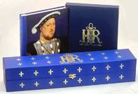
King Henry's Map of the British Isles with the 1537 'Angliae Figura' Map
1537102132London: Beacon Press for Folio Society. 15372009. Commentary volume: royal octavo cloth boards illustrated upper boards colour illus pp 158. In original gilt-decorated slipcase. Near fine condition very light scuffing to slipcase. WITH facsimile map limited to 2750 copies in original gilt-decorated velvet-lined slipcase. Near fine condition. Includes colour flyer for the map by the Folio Society. 'Angliae Figurae' King Henry's Map of the British Isles is reproduced from Cotton MS Augustus I.i.0 in the British Library and printed by the Beacon Press for The Folio Society. Map and accompanying commentary volume. 'Angliae Figura' was presented to King Henry VIII as a gift in 1537. Henry was the first English monarch to fully realise the potential of maps as practical instruments of government. The 'Angliae Figura' was both lavish and useful. It was the most realistic depiction of Britain to date. Beacon Press for Folio Society hardcover
Muir Books · Australie380,00 $AU≈ 250,46 €