125 résultats
1981130817London: Trigram Press 1981. First edition. Softcover. Introduction by Asa Benveniste. Includes poems and illustrations by Glen Baxter Ian Breakwell Ivor Cutler Anthony Earnshaw and Jeff Nuttall. A tight near fine copy in wrappers that are very lightly soiled. Trigram Press unknown books
1728279748James and John Knapton 1728. First. unbound. Sea Chart. Colored engraving. Sheet measures 21 1/4" x 25". Image measures 19 1/2" x 23 1/2".<br/><br/> This stunning map of the western hemisphere depicts Guiana and Brazil in South America presented on Edward Wright's projection also called a globular projection. It features rhumb lines to facilitate navigation. The map focuses more on the coastlines rather than the interiors. <br><br> This chart was made for the 1728 issued of "Atlas maritimus & commercialis or A general view of the world so far as relates to trade and navigation". The atlas which was meant to compete with Mount and Page's popular "English Pilot" was a collaboration between some of the leading cartographers of the time including Sir Edmund Halley John Senex Nathaniel Cutler Steven Parker and Daniel Defoe. The atlas unfortunately failed to achieve commercial success as great as its rival making this a hard-to-find map.<br><br>The map is in good condition with minor wear along the original folds and overall toning. Some toning over joint. Original plate mark is visible.<br><br>John Senex 1678-1740 was a kind of Renaissance man of the 18th-century map world working at times as a scholar surveyor engraver astrologer book seller and publisher of maps atlases and globes. In a short period he developed from an apprentice into one of the most important cartographers of the period and became a Fellow of the Royal Society of London as well as Official Geographer to Queen Anne of Great Britain. Although well regarded for his pocket-size maps Senex is probably best known for his globes which display a knowledge of astronomy equal to the skill of their craftsmanship. After his death in 1740 his wife Mary continued his business and continued to produce and sell cartographic works of high quality. Together their work represents a successful and valuable partnership in 18th-century mapmaking and publishing.<br><br> Sir Edmond Halley 1656--1742 was an English astronomer geophysicist mathematician meteorologist and physicist known for computing the orbit of the eponymous Halley's Comet. He was the second Astronomer Royal in Britain after John Flamsteed. Globular Projection maps were invented by Halley Harris and Senex. This is a wonderful example of their collaborative work.<br/><br/> James and John Knapton unknown books
1728268137London: James and John Knapton 1728. unbound. Sea Chart. Uncolored engraving.19 x 22 1/2 inches.<br/><br/> This beautiful early sea chart of the Coromandel coast in Southeast India covers the entire eastern coast of India as well as the western coast of Burma Myanmar and southern Thailand. Extends from modern day Kanyakumari north to include the Ganges River Delta the coast of Bangladesh and then south along western coast of Burma or Myanmar to Thailand. The northern parts of Sri Lanka or Ceylon are also included. The chart notes several villages and settlements along the coast. Islands coastal features rhumb lines and other geographical features are also noted.<br><br>The Coromandel Coast was one of the most important regions for the British Dutch French Danish and Portuguese during this time as much of the Indian trade was controlled through its various harbors and ports.<br><br>This chart was made by Senex for the 1728 issued of "Atlas maritimus & commercialis or A general view of the world so far as relates to trade and navigation". The atlas which was meant to compete with Mount and Page's popular "English Pilot" was a collaboration between some of the leading cartographers of the time including Sir Edmund Halley John Senex Nathaniel Cutler Steven Parker and Daniel Defoe. The atlas unfortunately failed to achieve commercial success as great as its rival making this a hard-to-find map.<br><br>The map is in good condition with minor wear along the original centerfold and overall toning. Map is lined with archival paper.<br><br>John Senex 1678-1740 was a kind of Renaissance man of the 18th-century map world working at times as a scholar surveyor engraver astrologer book seller and publisher of maps atlases and globes. In a short period he developed from an apprentice into one of the most important cartographers of the period and became a Fellow of the Royal Society of London as well as Official Geographer to Queen Anne of Great Britain. Although well regarded for his pocket-size maps Senex is probably best known for his globes which display a knowledge of astronomy equal to the skill of their craftsmanship. After his death in 1740 his wife Mary continued his business and continued to produce and sell cartographic works of high quality. Together their work represents a successful and valuable partnership in 18th-century mapmaking and publishing.<br><br> Sir Edmond Halley 1656--1742 was an English astronomer geophysicist mathematician meteorologist and physicist known for computing the orbit of the eponymous Halley's Comet. He was the second Astronomer Royal in Britain after John Flamsteed. Globular Projection maps were invented by Halley Harris and Senex. This is a wonderful example of their collaborative work.<br/><br/> James and John Knapton unknown books
1728269980London: James and John Knapton 1728. unbound. Sea Chart. Uncolored engraving. Sheet measures 25.5" x 30".<br/><br/> This stunning map of the western hemisphere depicts North America and South America presented on Edward Wright's projection also called a globular projection. It extends from the Hudson Bay south to Terra del Fuego with the oceans featuring rhumb lines to facilitate navigation. The map focuses more on the coastlines rather than the interiors. New Zealand appears in its embryonic form with partial coastline shown. Perhaps the most notable feature is the mapping of California as an island and the unmapped northwest coast of North America.<br><br>Insular California was first mentioned in the early 16th century. Although contrary evidence from various explorers was available by the 17th century that California was in fact a peninsula cartographers remained divided on the subject and California continued to appear on maps as an island.<br><br> This chart was made for the 1728 issued of "Atlas maritimus & commercialis or A general view of the world so far as relates to trade and navigation". The atlas which was meant to compete with Mount and Page's popular "English Pilot" was a collaboration between some of the leading cartographers of the time including Sir Edmund Halley John Senex Nathaniel Cutler Steven Parker and Daniel Defoe. The atlas unfortunately failed to achieve commercial success as great as its rival making this a hard-to-find map.<br><br>The map is in good condition with minor wear along the original folds and overall toning. Some toning over joint. Original plate mark is visible.<br><br>John Senex 1678-1740 was a kind of Renaissance man of the 18th-century map world working at times as a scholar surveyor engraver astrologer book seller and publisher of maps atlases and globes. In a short period he developed from an apprentice into one of the most important cartographers of the period and became a Fellow of the Royal Society of London as well as Official Geographer to Queen Anne of Great Britain. Although well regarded for his pocket-size maps Senex is probably best known for his globes which display a knowledge of astronomy equal to the skill of their craftsmanship. After his death in 1740 his wife Mary continued his business and continued to produce and sell cartographic works of high quality. Together their work represents a successful and valuable partnership in 18th-century mapmaking and publishing.<br><br> Sir Edmond Halley 1656--1742 was an English astronomer geophysicist mathematician meteorologist and physicist known for computing the orbit of the eponymous Halley's Comet. He was the second Astronomer Royal in Britain after John Flamsteed. Globular Projection maps were invented by Halley Harris and Senex. This is a wonderful example of their collaborative work.<br/><br/> James and John Knapton unknown books
1728250790London: James Knapton 1728. Sea Chart. Uncolored engraving.<br/><br/> An alternate projection of the globe as a flat map to the prevailing Mercator Projection. Includes rhumb lines and coastal details. From Atlas Maritimus a commercial sea atlas was published as a guide to British global commerce. Good condition with some stains along lower center fold. Sir Edmond Halley 1656--1742 was an English astronomer geophysicist mathematician meteorologist and physicist known for computing the orbit of the eponymous Halley's Comet. He was the second Astronomer Royal in Britain after John Flamsteed. John Senex 1678 to1740 was an English cartographer engraver and explorer who worked prominently in the 18th century. He is especially known for his maps of the world some of which have added elevations and minuscule detailed engravings. Globular Projection maps were invented by Halley Harris and Senex.<br/><br/> James Knapton unknown books
197166348Other: Arno Press. Very Good. 1971. Hardcover. 0405028202 . Reprint Edition. Part of The First American Frontier series. Ex-lib usual markings Near Very Good. . Arno Press hardcover books
201118151N.p.: Self-published 2011. Fine in illustrated thread-bound wrappers. First Edition. Octavo. An edition of 500 copies. Accordion-fold artists' book by David Kennedy Cutler featuring two booklets pasted into the internal pages. Includes two essays written by the artist pertaining to the Greenpoint oil spill and the nature of geological place accompanied by color and black-and-white images. N.p.: Self-published unknown books
2011156783Self-Published 2011. First Edition; edition of 500 copies. Softcover. As New. Accordion-fold white card with 3-color silkscreen ; 2 offset print booklets with 20 and 28 pp.; hand-stiched embroidery floss binding with tri-color tassel; removable 11 x 17 inch fold-out map with list of figures in the two booklets annotated on reverse. Includes two essays by Cutler about the Greenpoint oil spill The Blossoms of Greenpoint and the nature of geological place Against Geology accompanied by color and black-and-white images. Self-Published paperback books
199966849Privately Printed 1999. First Edition. Spiral bound. Very good. Limited to 1000 copies. An accomplished Aikidoist and a noted artist render in words and drawings the relationship between movement and breath that is at the heart of the discipline. The text is printed in three colors: wine red dark blue and dark green. Oblong quarto. Original spiral bound paper wrappers. Some mild edgewear; else very good or better. Privately Printed unknown books
1998240063Northampton MA: CALC Center for Amazonian Literature and Culture 1998. Paperback. xiv 163p. texts in Spanish & Portuguese translated to English introduction poetry essays contributor notes illustrations. A journal presenting in translation and defining the syncretic and indigenous literary traditions of the countries of the Amazonian Basin subtitle from back cover statement. CALC (Center for Amazonian Literature and Culture) paperback books
19543548Stanford: Standford University Press 1954 First edition. xiii 271pp. Fine with soiled and worn dust jacket. Biography of this Californian: Stanford University insurance business journalism San Francisco Call Trustee of Stanford etc. Standford University Press unknown books
1954WRCAM4344Stanford Ca 1954. 271pp. Quarto. Cloth and boards. Ex-library else fine. In dust jacket. The memoirs of a country boy made good; Cutler was a business entrepreneur and had a hand in the building of the Bay Bridge the Golden Gate Bridge and other notable ventures. hardcover books
195412431.1Stanford CA: Stanford University Press 1954. 1st edition. Linen cloth spine with grey-green paper wrapped boards. Dust jacket. NF/VG sp panel sunned/some wear & soiling. 271 pp including index 4to. <br/><br/>Story of the men who built the west around Stanford anyway. Stanford University Press hardcover books
2007143385New York New York: American Illustrators Gallery / Judy Goffman Fine Art 2007. Softcover. VG- Ex-gallery lib. small label at front cover ink stamping and pencil markings to first page. Color illus. stapled wraps; 23 pp.; 35 color figures. Includes works by J. C. Leyendecker N. C. Wyeth Dean Cornwell Gil Elvgren Leslie Thrasher and others. American Illustrators Gallery / Judy Goffman Fine Art unknown books
32505Other: Other. Very Good. Hardcover. 1966 facsimile of the 1787 edition. Reprint of Howes C-986--"First comprehensive description of the prsent state of Ohio. " Readex Microprint Great Americana series very good condition. . Other hardcover books
1728236366London: James Knapton 1728. hardcover. Two parts in one volume. Illustrated with 53 of 54 fine uncolored copper plate maps last celestial chart is missing with a full size facsimile version provided from the British Library edition and 5 fold-out diagrams tipped into the second text. Title page printed in black and red foreword preface list of subscribers and list of charts. Dedication page has a repair to the margin. "Atlas maritimus & commercialis" 340 pp. plus index. "General Coasting Pilot" 195 pp. plus maps. Page numbers written in ink. Elephant folio 21.25" x 13" scuffing and corner wear to original brown leather binding gilt spine in 8 compartments. Some toning and light scattered foxing to text and maps. Repairs to World Chart North America chart and Celestial map along bottom fold out small abrasion in margin of China map. Bookplate pasted down with Coat of Arms of Verney.<br/><br/> This commercial sea atlas was published in 1728 as a guide to British global commerce. Today it is a historically significant English overview of world trade during a rapid period of development of the British Empire's trading power. The atlas consists of two parts. The first is the "Atlas Maritimus & Commercialis" proper which provides a geographical overview of the world as it relates to trade and navigation. It also gives an account of contemporary commerce including the traded commodities of each country. The second part is "A General Coasting Pilot" by Nathaniel Cutler which provides sailing directions. The volume was published anonymously though the maps are often attributed to Sir Edmond Halley the Astronomer Royal of Britain who also wrote the prefatory note discussing the charts' use. The atlas's emphasis on commerce in addition to geography distinguishes it from "The English Pilot" the period's standard in maritime charts. It was also notable for covering the entire globe including the south and west coasts of America in one volume. This is an early issue of the Atlas with A Chart of the Coast of Scotland on a globular projection. London: 1728. <br><br>Sir Edmond Halley 1656--1742 was an English astronomer geophysicist mathematician meteorologist and physicist known for computing the orbit of the eponymous Halley's Comet. He was the second Astronomer Royal in Britain after John Flamsteed. John Senex 1678-1740 was a kind of Renaissance man of the 18th-century map world working at times as a scholar surveyor engraver astrologer book seller and publisher of maps atlases and globes. In a short period he developed from an apprentice into one of the most important cartographers of the period and became a Fellow of the Royal Society of London as well as Official Geographer to Queen Anne of Great Britain. A wonderful rarity about 'Globular Projection" maps which was invented by Halley Harris and Senex. Includes the unforgettable large four sheet map "A Chart of the Atlantick Ocean Shewing the Coast from Texel to C. Cantin".<br/><br/> James Knapton unknown books
19402304115New York: The Macmillan Company 1940. 4th Printing. 4th Printing. Very Good/No Jacket. Codding Mildred B. Fourth printing. Presentation copy from 17 New York Hospital staff members to the assistant surgeon in 1940 Edward W. Douglas. x 181 pp. From the Preface 1940: "The Atlas of Surgical Operations is the result of the difficulty experienced in answering the countless questions of internes resident surgeons students and assistants over a period of twenty years of teaching as to where they might learn about the intimate technical steps of surgical procedures. It has long been apparent that no single volume could contain both adequate descriptions of all surgical diseases as well as a complete recital of the steps in the operations which such diseases require. As a result the admirable textbooks which the medical students of today use most frequently are those describing diseases for which surgery may seem advisable. The more extended attempts to write surgical textbooks for the practicing surgeon compressing both diagnosis and therapy into a single volume have necessarily resulted in incomplete descriptions which fail to give the information provided. This Atlas contains most of the common surgical procedures which are standardized and about whose technical performance there exists no essential difference of opinion. Wherever several procedures are generally recognized as useful and desirable we have as a rule selected the one which we think has best stood the test of time in the believe that it is better for the young surgeon to perform one procedure well than several procedures improperly. Should the Atlas fulfill our hopes other procedures will doubtless appear in subsequent editions. The format of the book is simple. We wished the drawings to tell the story and wished to include no more text than would conveniently fit opposite the plates." CONTENTS: General Considerations: Surgical Technique - Anesthesia - Preoperative and Postoperative Care; Surgical Operations: Neck - Chest - Abdominal Wall - Gastro-Intestinal System: Stomach Gallbaldder and Bile Ducts Small Intestine Appendix Large Intestine Sigmoid--Rectum--Anus - Spleen - Gynecological System: Abdominal Procedures Vaginal Procedures - Extremities. The Macmillan Company unknown books
1943D6165New York: Macmillan 1943. Ninth printing. Hardcover. Very Good. Blue cloth lettered in gilt on upper board and spine. Spine and edges of boards lightly scuffed; spine tips and corners bumped. Bookplate and bookseller's ticket on front paste-down; discreet ownership markings on front and rear endpapers; otherwise internally bright and clean. <br/><br/> Macmillan hardcover books
197733291Boston: Nimrod Press. Fine. 1977. Paperback. Second edition paperback. Fine in printed wraps. . Nimrod Press paperback books
1993164124New York: Dutton 1993. 335p. very good first mass-market paperback edition in pictorial wraps. First novel in the series about an amateur sleuth/screenwriter. Set in Hollywood. Gunn page 136. Dutton unknown books
1976027956Basel Etc.: S. Karger 1976. vi 217p. b/w text figures and tables original stiff wrappers Interdisciplinary topics in gerontology 9. S. Karger unknown books
2007225673London: Allison and Busby 2007. First Edition. Hard Cover. Fine binding/Fine dust jacket. Signed. No marks of any kind. Fine binding / Fine dust jacket. Allison and Busby unknown books
186716362Cleveland: Fairbanks Benedict & Co. Very Good. 1867. Hardcover. Rough wraps with chips and soil and wear; backstrip splitting; rear wrap missing; 28 pages overall clean; Good . Fairbanks, Benedict & Co. hardcover books
2005SKU1037490Naval Institute Press 2005-03-15. Hardcover. Very Good/Dust Jacket Included. 1591141508 Dust jacket and book are clean has a very good binding no marks or notations. Naval Institute Press hardcover books
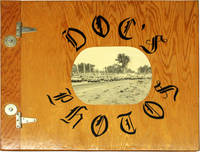
198017571Idaho: n.p. 1980. Fine in lightly varnished plywood boards bound with two metal hinges along the spine gutter with a photograph adhered to the front cover. Unique vernacular photo album and scrapbook detailing the small town racing culture of Rupert Idaho. Extraordinarily lavish in size and execution the album features photographs by Dr. Elvin Cutler a photography hobbyist of local notoriety recognized for his images of the Minidoka Speedway its drivers and attendees. Includes 89 original color and black-and-white photographs ranging in size from snapshot to 8 X 10 inches with several larger format prints. Many have been signed by the photographer with his nickname "Doc"; several others have been annotated with humorous captions written underneath. The book was assembled by members of the town's Magic Valley Stock Car Racing Association and presented to Cutler as a sign of their gratitude and appreciation for his relentless documentation of the Minidoka Speedway with various pieces of ephemera including newspapers clippings and flyers from the racetrack adhered to the album's pages. Contents are housed in an extravagant handmade plywood book hinged and bolted along the spine gutter. A remarkable collection of amateur photography and vibrant portrait of one of the defining pastimes and national obsessions of small town USA notable for its stunning photographic compositions and idiosyncratic homespun design. Fine in lightly varnished plywood boards bound with two metal hinges along the spine gutter with a photograph adhered to the front cover. [Idaho: n.p. unknown books