417 résultats
18538087London: James Nisbet and Co. 1853 Second English edition published the year after the first. Original red blindstamped cloth with gilt spine. . Two volumes small octavo. Six engraved plates. Binding extremities lightly worn spines a bit cocked 1 1/2 inch tear along front joint of Volume I. A good tight set. Susan Warner 1819-1885 grew up in New York City. When her family was in difficult financial straits she took up writing. Her first novel The Wide Wide World appeared in 1849 followed by Queechy which appeared at the end of 1850. Both were extremely popular in both England and America. "The source of her popularity…seems to have been her sensibility which equaled that of any of the more extravagant English novelists of the later eighteenth century. It was her descriptions of the emotions of her characters—emotions that found expression in tears on almost every page—that compensated in the minds of her readers for the absence of action" Granville Hicks writing in the D.A.B. James Nisbet and Co., hardcover
1837200919006New Haven: H.C. Peck 1837 2020-09-19. First Edition. Hardcover. Very Good. New Haven. Original quarter-bound leather with illustrated covers. New Haven: H.C. Peck 1st Ed. 1837 12mo 288pp. Illustrated in B/W. Firm binding light buckling to text blocks pastdowns/end pages foxed exterior rubbed and worn one small tear to head of spine. Well packaged ships with tracking. H.C. Peck hardcover
1841BOOKS236253Worcester MA: Dorr Howland & Co. G/No Dustjacket. 1841. . Leather. Illustrated with numerous engravings and fold-out colored map torn. . 8vo. 576pp. Rubbed worm-tracks on front cover; heavily stained and foxed; owners markings; tears to text p. 445-6 . Dorr, Howland & Co. hardcover
186713651New York: F. W. Beers 1867. Very good. 14.5 by 17.5 inches engraved map. This is from the Beers atlas that includes Westchester Putnam & Dutchess County which is unusual. Very good condition. F. W. Beers unknown
186713664New York: F. W. Beers 1867. Very good. 26 by 20 inches engraved map on onion paper. Includes a plan of Cortlandt Cemetery. This is from the Beers atlas that includes Westchester Putnam & Dutchess County which is unusual. Very good condition. F. W. Beers unknown
186713656New York: F. W. Beers 1867. Very good. 23 by 26 inches engraved map on onion paper. This is from the Beers atlas that includes Westchester Putnam & Dutchess County which is unusual. Very good condition. F. W. Beers unknown
186713678New York: F. W. Beers 1867. Very good. 14.5 by 17.5 inches engraved map. This is from the Beers atlas that includes Westchester Putnam & Dutchess County which is unusual. Very good condition. F. W. Beers unknown
186713683New York: F. W. Beers 1867. Very good. 14.5 by 17.5 inches engraved map which includes views of Washington Hollow and Salt Point. This is from the Beers atlas that includes Westchester Putnam & Dutchess County which is unusual. Very good condition. F. W. Beers unknown
186713696New York: F. W. Beers 1867. Very good. 14.5 by 17.5 inches engraved map. Includes views of Croton Falls North Salem and Purdy Station. This is from the Beers atlas that includes Westchester Putnam & Dutchess County which is unusual. Very good condition. F. W. Beers unknown
186713692New York: F. W. Beers 1867. Very good. 34 by 20 inches engraved map on onion paper. This is from the Beers atlas that includes Westchester Putnam & Dutchess County which is unusual. Very good condition. F. W. Beers unknown
187929569New York: Robert Carter and Brothers 1879. Hardcover. First Edition First Printing. 4.5 x 6.5in. 313pp. 6pp. ads. Publisher's blind-stamped cloth boards with gilt titling and decoration. NEAR FINE. Shows marginal shelf rubbing along the extremities former owner plates at the paste-down and first chapter page otherwise remains Fine having been exceptionally well maintained. As pictured. Robert Carter and Brothers hardcover
18552305200Philadelphia: Lippincott Grambo & Co 1855. First Edition. First Edition. Very Good/No Jacket. First edition Sabin 9893. Spine and boards toned spine head lightly rubbed. 1855 Hard Cover. viii 17-454 pp. "A remarkable repository of medical scandal." Garrison History of Medicine "Charles Caldwell May 14 1772 Lippincott, Grambo & Co unknown books
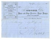
18558018993Springfield Massachusetts 1855. Fine; creased where previously folded. A receipt on company stationary for painting services rendered dated 1855 in ink by David Warner House and Sign Painter Paper Hanger and Glazier of Springfield Massachusetts. Measures 5.5" by 7"; printed on blue paper. unknown
188264194<p>original-colour lithograph. Botanical print from "Orchid album Comprising Colored Figures and Descriptions of New Rare and Beautiful Orchidaceous Plants" Volume 1 pl. 24. John Nugent Fitch 1840–1927 was a British botanical illustrator and lithographer best known for his contribution of 528 plates to The Orchid Album a landmark work of eleven volumes published between 1872 and 1897. Benjamin Samuel Williams 1822 - 1890 was an English orchidologist in London known mainly for his horticultural notes on orchids in publications such as The Orchid Grower's Manual London 1871 Select Orchidaceous Plants London 1862 onwards and The Orchid Album London 1882-97. These flowers are very large and of fine substance the two lower sepals having together almost a circular outline and measuring across the centre 2-1/2 inches. These lateral sepals are broadly semi-ovate and apiculate and of a rich magenta-crimson flushed with bluish-purple. Reference: Williams The Orchid-grower's Manual p.491; https://en.wikipedia.org/wiki/John_Nugent_Fitch; https://commons.wikimedia.org/wiki/R._Warner_&_B.S._Williams_-_The_Orchid_Album; https://www.google.com.ph/books/edition/_/MIsUAAAAYAAJhl=en&gbpv=1; https://www.biodiversitylibrary.org/page/35713844#page/1/mode/1up. Condition: very good.</p> Robert & Williams Warner and Benjamin Samuel Williams, London.
1891C0553Denver CO: The Mills Publishing Co 1891. "Embracing the General Statutes of 1883 and all general laws enacted since that compilation except the Code of Civil Procedure in force January 1 1891 with digested notes of judicial decisions construing or illustrating the same." 1439 pages. Covers detached spine missing. Tape repaired with packaging tape. First 6 leaves detached. Stamped on cover and page edges "Big Five". Beginning and ending pages tattered at edges with some worming. Interior pages clean/crisp for the most part. Full-Leather. Poor. 8vo - over 7¾" - 9¾" tall. The Mills Publishing Co Hardcover
1878323231Boston: Houghton Mifflin 1878. Hardcover. Near Fine. Eighth edition. Near fine with light scuffing along the edges of the spine. Houghton Mifflin hardcover books
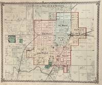
1876754Chicago: Warner & Beers 1876. 16 x 13 1/4 inches. Very good condition. This is a very nice single page map of Decatur IL and vicinity. It was printed in black and white. Color was then added at the time of publication.There were five wards in the city each delineated by the use of color. The railroad landscape was prominently placed in this map. The Illinois Central main line runs through the right center of the map. The Wabash intersects on the east side of town. The Indiana & Illinois Central runs through the major junction. Overall a very nice transportation map of Decatur Illinois. Warner & Beers unknown
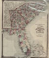
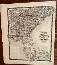
1875726chicago: Warner & Beers 1875. 17 x 13 3/4 inches. Very good condition. This is a very handsomely composed map of the Southeast United States. It covers North Carolina South Carolina Georgia and Florida. The map was hand colored at the time of publication. It captures each county using a distinctive pastel color scheme. The nations railroad network was extensive and through the state of Georgia. The state of Florida shows a less dense network and non-existent network in south Florida. the lands that far south were not habitable year round and consequently less economic development to support year-around rail operations. This is a fine example of the mapmakers art in the latter half of the 19th century. Warner & Beers unknown
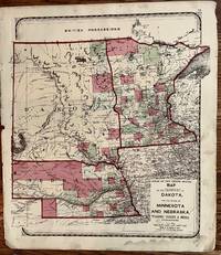
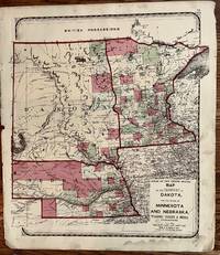
1872286Chicago: Warner & Beers 1872. 17 1/4 x 14 1/4 inches. Very good. Beautiful map of the Northern Plains States. The county formation in the Dakota Territory is much more advanced over the previous year's Warner Higgins and Beers map. The same goes for Minnesota and Nebraska except to a lesser degree. One might say that this map provides a snapshot of the agricultural frontier of the period. Warner & Beers unknown
1874252New York: H. H. Lloyd & Co 1874. 16 1/2 x 14 inches. Very good. Beautiful map oof the entire peninsula of Florida with the adjacent states to the north. H. H. Lloyd & Co unknown
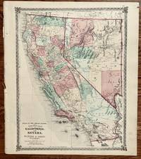
1872321Chicago: Warner & Beers 1872. 18 x 15 1/2 inches. Very good. Very nice single sheet map of California and Nevada. All counties are designated in color applied by hand. The latest info on road raids is posted on the map with the U.S. Mail Route displayed near San Diego. The fight for railroad access was critical in the development of Southern California towns. Warner & Beers unknown
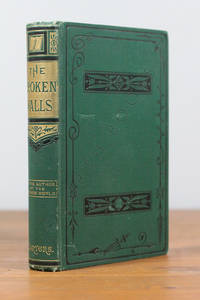
1882E13359BBoston: Houghton Mifflin 1882. Hardcover. fine. Hardcover octavo in brick colored cloth decorated and lettered in gilt. 496 pp. Decorated chapter headings. Frontispiece engraving of "The Wooden Man" with tissue guard. Early edition. Along with its sequel "In The Levant" a record of Warner's experiences and observations of an Oriental journey in 1875-6. A tight bright example. Four pages of handwritten notes from the Cream Ridge New Jersey Circulating Libraryestablished Nov. 25th 1871 including one page of the rules of the library and two pages of the order of the passing of the book that ists the name of the borrower and the dates taken and returned. No other library markings cards etc. <br/><br/> Houghton Mifflin hardcover
1882E13360Boston: Houghton Mifflin 1882. Later printing. Hardcover. fine. Octavo hardcover in brick colored cloth decorated and lettered in gilt. 391 pp. with index. The eleventh edition so stated on the title page. Along with its "prequel" "My Winter On The Nile" a record of Warner's experiences and observations of an Oriental journey in 1875-6. A tight bright example. Four pages of handwritten notes from the Cream Ridge New Jersey Circulating Libraryestablished Nov. 25th 1871 including one page of the rules of the library a page list of library members verso of the title page and a page of the date order of the passing of the book . No other library markings cards etc. <br/><br/> Houghton Mifflin hardcover
1878323231Boston: Houghton Mifflin 1878. Hardcover. Near Fine. Eighth edition. Near fine with light scuffing along the edges of the spine. Houghton Mifflin hardcover
1871285Chicago: Warner Higgins and Beers 1871. 16 1/4 x 14 1/2 inches. Very good with minor soiling. This map was a component of H. H. Lloyds & Co "Atlas of the United States." Dakota was not a state until November 2nd of 1889 but county formation within the Territory was noted. The composition of this region highlights the post war and post-transcontinental railroad settlement patterns. The Union Pacific Railroad Wass completed two year before the map was made. Significant settlement had occurred along the railroad as had previously occurred along the Missouri River. This is a very nice cartographic artifact of the region during its important settlement period. Warner Higgins and Beers unknown