Lincoln AbrahamABAA

12 résultats
1518100999Newspaper disbound 23" x 16" 8 pp. Probably removed dbd minor staining and browning a little creasing and fading; otherwise very good.This is an early report under the heading "Important Assassination of President Lincoln." This is the second morning edition with the 3 a.m. update from Edward Stanton the Secretary of War which indicates Lincoln was still alive but in very bad shape. The article describes John Wilkes Booth "the actor" as the alleged assassin of the president. It describes how Booth entered Lincoln's box and after shooting him stating "Sic semper tyranis" before he leaped on to the stage. This report gives considerable detail about the how Washington reacted to the news and the scene at Lincoln's deathbed. There is also a good deal of coverage of the assassination attempt on Secretary of State William Seward. This paper represents an important piece of American history. books
159040297N.p. 1590. Image area 19-1/2" x 12-7/8" in 28" x 23" mat. 1 vols. Imperfectly colored along crease down center small and unobtrusive dampstain in one corner. Still a nice piece. Image area 19-1/2" x 12-7/8" in 28" x 23" mat. 1 vols. Abraham Ortelius 1527-98 was a Flemish geographer of German origin. His major work Theatrum Orbis Terrarum 1570 with later revisions and addendums was the first modern atlas. It was based on contemporary charts and maps and contained a collection of plates engraved by Frans Hagenberg in a uniform size and format. The Theatrum preceded the first atlas of Ortelius' good friend Gerardus Mercator. In fact popular sentimental legend has it that Mercator delayed publication of his own work so that his younger friend's would appear first. Although this simply isn't true Mercator wasn't ready the legendary cartographer did complement Ortelius for the "care and elegance" he had put into the Theatrum. unknown books
159037978np 1590. Image area 19 1/2 x 13 1/2 inches in 28 x 23 inch mat. Single crease down center with one 1/2 inch spot worn through otherwise a nice handsome map. Image area 19 1/2 x 13 1/2 inches in 28 x 23 inch mat. Abraham Ortelius 1527-1598 was a Flemish geographer of German origin. His major work Theatrum Orbis Terrarum 1570 with later revisions and addenda was the first modern atlas. It was based on contemporary charts and maps and contained a collection of plates engraved by Franz Hagenberg in a uniform size and format. The Theatrum preceded the first Atlas of Ortelius' good friend Gerardus Mercator. In fact popular and sentimental legend has it that Mercator delayed publication of his own work so that his younger friend's would appear first. although this simply is not true Mercator wasn't ready the legendary cartographer did compliment Ortelius for the "care and elegance" he put into his "Theatrum. unknown books
1587239611Antwerp: Abraham Ortelius 1587. unbound. Map. Uncolored engraving. Image measures 14" x 19.5".<br/><br/> These two maps on one sheet detail areas of western Mexico above and the Greater Antilles below. Ortelius created them from information compiled by other mapmakers such as Mercator Guttierez and Alsons de Sata Cruz. These sources allowed him to include a wealth of detailed information that is mostly if not entirely accurate. Above the map of western Mexico shows the area around Culiacan and the Spanish settlement of Villa S. Michaels which was notable in the period for its silver mines. It begins at the Yucatan and extends through the Cayman Magnus and the Caymanes. The map below illustrates the Greater Antilles including Cuba Hispaniola Jamaica St. Jois Insula St. Johns the Bahamas Virgin Islands and the Windward Islands all in impressive detail. The section of South Florida also shows suggestion of the Florida Keys which was uncommon for these period. A notable error is that the Tropic of Cancer is labelled as the Tropic of Capricorn. A highly decorative note with strapwork and foliage fills the acific Ocean to the left of Mexico and provides information about the upper map. The lower map also has a framed cartouche with birds perched atop it. Two ship illustrations float in the choppy seas around the islands. The map is a first state from the 1587 French edition of Ortelius's "Theatrum Orbis Terrarum." It is in good condition with no chips or tears. Stain at the center seam in the lower margin not affecting the image some overall stains. French text on verso. Abraham Ortelius 1527--1598 a Flemish cartographer and geographer is widely regarded as one of the important and influential cartographers in history. He is known for his "Theatrum Orbis Terrarum" which was the first modern atlas. This map is an uncommon uncolored example of this wonderful map by Ortelius.<br/><br/> Abraham Ortelius unknown books
1592273298Antwerp: Abraham Ortelius 1592. unbound. Map. Uncolored engraving. Sheet measures 16" x 21".<br/><br/> This beautiful 1588 map by Abraham Ortelius depicts Holland or the Netherlands in exceptional detail. The map covers the regions near the Wadden Sea roughly covering modern day provinces of North Holland South Holland and Utrecht. The map centered on Amsterdam is oriented with north to the left. Topographical and geographical features such as mountains and cities are beautifully rendered in profile.<br><br>The waters surrounding the region are shown with waves and include several illustrations of ships throughout. This is the first state of the map with later states showing a stippled sea rather than waves. Includes a large strapwork title cartouche scale of miles with a divider in the lower left. The Royal coat of arms is presented in the top left. The map also includes a 16-point compass rose.<br><br>Ortelius based this map on the work of Jacob van Daventer. Published in the 1588 edition of Ortelius' famous "Theatrum Orbis Terrarum" which is historically considered the first modern atlas. Based on the text on verso only 300 copies of this particular edition were ever printed van der Broecke 79.<br><br>The map is in good condition with minor wear along the original centerfold. Minor foxing at places. Original plate mark is visible. Latin text on verso.<br><br> Abraham Ortelius 1527--1598 a Flemish cartographer and geographer is widely regarded as one of the important and influential cartographers in history. He is known for his "Theatrum Orbis Terrarum" which was the first modern atlas. Hard to find in black and white.<br/><br/> Abraham Ortelius unknown books
1584299318Antwerp: Abraham Ortelius 1584. unbound. Map. Engraving. Image measures 14" x 18 3/4". Light staining and toning on right margin but otherwise is good condition.<br/><br/> A representation of some islands in the Mediterranean Sea. Abraham Ortelius 1527-1598 a Flemish cartographer and geographer is widely regarded as one of the important and influential cartographers in history. He is known for his "Theatrum Orbis Terrarum" which was the first modern atlas. Van den Broecke #141<br/><br/> Abraham Ortelius unknown books
1595223506Antwerp: Philippe Galle 1595. unbound. very good. Miniature map. Uncolored engraving. Image measures 3 1/8" x 4.25".<br/><br/> Great miniature map of Ischia off the coast of Naples detailing the volcanic landscape. From the 1595 pocket edition of Ortelius' "Theatrum Orbis Terrarum" or "Epitome" with text by Pieter Heyns. With Latin text on verso. Small tear and chip to upper right light staining to lower margin.<br/><br/> Philippe Galle unknown books
15846753Antwerp: Ortelius 1584. Map on thick paper measuring 8.75 x 7 in 22.25 x 17.75 cm in the image. Taken from the Theatrum orbis terrarum of Ortelius. One of the earliest maps of the kingdom of Huasteca or Guasteca present-day Tamaulipas originally printed on a single sheet with two other maps of Florida and Peru but here presented by itself alone. This is hand-colored with titles in Latin and ornate title cartouche. Very good. <br/><br/> Ortelius unknown books
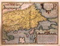
1592272534Antwerp: Abraham Ortelius 1592. unbound. Map. Engraving with hand color. Image measures 14" x 18 3/4".<br/><br/> This beautiful 1592 map by Abraham Ortelius depicts the Balkan Peninsula or the Balkans extending from The Sea of Marmara Istanbul and the Bosporus Strait westward to Macedonia including Bulgaria. Portions of the Black Sea and the Thrakikon Pelagos are also shown. Topographical and geographical features such as mountains forests and cities are beautifully rendered in profile.<br><br>Ortelius based this map on the 1560 South-East Europe map by Gastaldi and on on information from numerous ancient sources specifically Herodotus Plinius Strabo Appianus Virgilius Plutarchus and Sidonius. A beautifully engraved title cartouche adorns the top left of the map. Two additional cartouches containing text are also included in the top and bottom right.<br><br>This map was published in the 1592 edition of Ortelius's famous "Theatrum Orbis Terrarum" which is historically considered the first modern atlas. Based on the Latin text on verso only 525 copies of this particular atlas were ever printed van der Broecke 214. The map is in good condition with minor wear and toning along the original centerfold. Light stain in lower left margin. Minor foxing with Latin text on verso.<br><br>Abraham Ortelius 1527--1598 a Flemish cartographer and geographer is widely regarded as one of the important and influential cartographers in history. He is known for his "Theatrum Orbis Terrarum" which was the first modern atlas. Van den Broecke #214<br/><br/> Abraham Ortelius unknown books
1570214216Antwerp: Ortelius Abraham 1570. unbound. very good. Map. Uncolored engraving. Image measures 14 3/8" x 19.75".<br/><br/> Beautiful map of southern Italy. Latin text on verso. Published in "Theatrum Orbis Terrarum". Minor scattered staining particularly in margins. Full original margins.<br/><br/> Ortelius, Abraham unknown books
15782206Antwerp: Plantin 1578. Hardcover. Very Good. 4to - over 9¾ - 12" tall. 4to. 23 x 16.5 cm 4 ff. 417 1 pp. 1 f. Bound in contemporary vellum over flexible boards head slightly chipped; early signature on t-p. Woodcut 'golden compass' device of the Plantin press on title. Generally good. First edition of this early modern geographical dictionary published alongside the first Plantin edition of Ortelius' successful Theatrum orbis terrarum Antwerp 1579 and listing thousands of names both ancient and modern for "peoples regions islands great and small towns mountains foothills forests seas bays lakes" etc. depicted in the atlas. Earlier versions of the Synonymia had previously appeared as indices to the atlas containing a little over 2000 entries; "in all this first version of Ortelius' geographical dictionary in the form of a separate book includes approximately 10000 entries" Meurer. Ortelius' methodology in the present volume differs from that of his earlier indices: a parallel glossary of non-Latin names has been turned into a bilingual appendix and Ortelius relies almost completely on classical authors quoting moderns only when he cannot go straight to the source. The significance of these alterations for the author's role not as mapmaker but as linguist and lexicographer is hard to overstate: his introduction declares that he undertook the new Synonymia largely out of frustration at the scholarly inadequacy of current Latin lexica including earlier editions of his own which frequently printed inexact or even nonexistent terms sometimes on dodgy authority. Voet 1835; Skelton Theatrum orbis terrarum facsimile 1964; Meurer in Abraham Ortelius and the First Atlas ed. Voet pp. 331-346. Plantin hardcover books
159517860Antwerp: Ortelius 1595. Copper-engraved map with full original colour Latin text on verso of one half of the sheet in excellent condition apart from a small expert repair to the left blank margin and a small section of the upper blank margin torn away. A superb map of Europe by one of the greatest names in the history of cartography.<br/> <br/>This important map of Europe derives in large part from Mercator's work; Russia from Jenkinson's map; Scandinavia from Olaus Magnus. The relatively modest cartouche shows a partially covered and apparently distraught Europa sitting on the back of Zeus in the form of a placid bull he the unwelcome lover of Europa both gazing toward Europe curious about its future. Published in a Latin edition of Ortelius' s ground-breaking atlas Theatrum Orbis Terrarum.<br/> <br/>van den Broecke Ortelius Atlas Maps 5. Ortelius unknown books