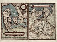
"DANMARK - ORTELIUS, ABRAHAM.Livre Rare Book
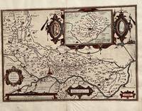
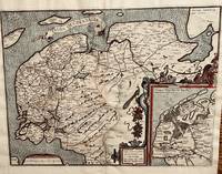
Thietmarsiae Holsaticae Regionis Partis Typus. Auictore Petro Boeckel with Rugiae Usedomiae et Iulinae Wandalicarum Insularum Vera Descriptio. Image of Dittmarschen a part of Holstein by Petrus Boeckel with A true image of Rügen and Iulinia Islands of Wandalica. 1584.
158464215Antwerp.: Abraham Ortelius. circa1584. Two engraved maps on laid paper each 30.3 x 19.5 cm printed on the one sheet 48 x 60 cm original fold attractive hand colour with related French text on verso slight toning and spotting to the margins but the maps in very good condition preserved in a modern window mount. Attractive maps of the German coast published in Ortelius' great atlas "Theatrum Orbis.". The left-hand map showing the mouths of the Elbe complete with sea monster and Eider Rivers and the coast of Schleswig-Holstein; the right-hand map of the Baltic coast with the Pomeranian islands of Rugen and Usedom. . (Abraham Ortelius). unknown

Asia Bookroom · Australie575,00 $AU≈ 378,98 €