Ortelius, AbrahamBiblio.com
201 résultats
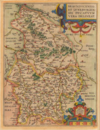
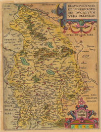
160235921Antwerpen: Vrients 1602. Still in acceptable condition. 31 x 235 cm 12.25 x 925 inches. Hand-Colored Original Copperplate Engraving by Abraham Ortelius depicting Braunsvicensis et Luneburgensis Ducatuum Vera Delineat. Published Antwerpen Vrients 1602. Sheet: 31 x 235 cm 12.25 x 925 inches. A fine and original hand-colored example of Ortelius's celebrated cartographic work documenting this region of Germany with the precision and decorative artistry characteristic of the 16000s. Abraham Ortelius 1527-1598 was a Flemish cartographer and geographer from Antwerp widely regarded as the creator of the first modern atlas. His landmark publication Theatrum Orbis Terrarum 1570 set the standard for atlas-making for the next century presenting uniform copper-engraved maps with scholarly commentary. By Ortelius's death the Theatrum had appeared in 25 editions in seven languages. In 1575 King Philip II of Spain appointed him Royal Geographer. His maps engraved with extraordinary precision are among the most sought-after in antique cartography held in collections including the Plantin-Moretus Museum in Antwerp the Library of Congress and the British Library.This original copperplate engraving with original hand coloring depicts the region of Braunsvicensis et Luneburgensis Ducatuum Vera Delineat. published in Antwerpen Vrients 1602. The map records the political and geographic boundaries of the region as understood in 1602 offering a fascinating window into the history of German territorial organization. Sheet measures 31 x 235 cm 12.25 x 925 inches. In good condition overall with minor signs of age appropriate for a 16th-century engraving. Ready to frame. Broe. 99 Vrients unknown
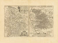
161232756Antwerpen: Vrients 1612. In excellent condition. 310 by 475mm 12¼ by 18¾ inches. Original antique copper engraving uncolored. Two maps on one doublepage sheet the Duchy of Brunswick-Lüneburg and the environs of Nuremberg. The Nuremberg area is shown on one map. In the north the map extends to Erlangen / Uttenreuth and in the south to Schwarzach. In the upper margin is the title Norimberg. Agri fidissima descrip. And below the map there is a large painted scrollwork cartouche and privilege. In the west the map extends from the Rednitz to Hersbruck in the east. Locations forests rivers lakes etc. were decoratively worked out. Koe. Ort. 42 Vrients unknown
160235922Antwerpen 1602. Kräftig und gleichmäßig gedrucktes Exemplar. Tadellos. . 31 x 234 cm 12.25 x 925 inches. Hand-Colored Original Copperplate Engraving by Abraham Ortelius depicting Braunschweig Herzogtum. Published Antwerpen 1602. Sheet: 31 x 234 cm 12.25 x 925 inches. A fine and original hand-colored example of Ortelius's celebrated cartographic work documenting this region of Germany with the precision and decorative artistry characteristic of the 16000s. Abraham Ortelius 1527-1598 was a Flemish cartographer and geographer from Antwerp widely regarded as the creator of the first modern atlas. His landmark publication Theatrum Orbis Terrarum 1570 set the standard for atlas-making for the next century presenting uniform copper-engraved maps with scholarly commentary. By Ortelius's death the Theatrum had appeared in 25 editions in seven languages. In 1575 King Philip II of Spain appointed him Royal Geographer. His maps engraved with extraordinary precision are among the most sought-after in antique cartography held in collections including the Plantin-Moretus Museum in Antwerp the Library of Congress and the British Library.This plate presents a original copperplate engraving with original hand coloring depicting the city of Braunschweig Herzogtum published in Antwerpen 1602. The view is framed with a decorative Baroque cartouche containing the title inscription. Such topographic views from Ortelius's workshop are primary historical documents of German urban history in the 1600s now prized equally by historians map collectors and interior decorators. Sheet measures 31 x 234 cm 12.25 x 925 inches. In good condition overall with minor signs of age appropriate for a 17th-century engraving. Retains its original contemporary hand coloring. Ready to frame. Koem. Ort. 33 unknown
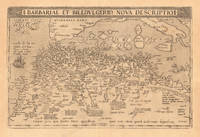
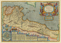
160819024Antwerpen: Platin 1608. Other. In excellent condition. 330 by 500mm 13 by 19 inches. Original copper engraving published 1608 in an Italian text edition of the " Theatrum Orbis Terrarum. A good and strong impression of this map. This antique map shows North Africa with the Mediterranean Sea and the Atlantic coast. The map is equipped with many place names rivers mountains towns a small part of Italy Sicily the islands Corsica Sardinia Menorca Mallorca etc. The map is ornated with a large title cartouche in the upper margin as well we find for decoration a sea monsters and a ship in the sea. Villages and towns are shown as miniature views. Ortelius was born on 14 April 1527 in the city of Antwerp which was then in the Habsburg Netherlands modern-day Belgium. The Orthellius family were originally from Augsburg a Free imperial city of the Holy Roman Empire. In 1535 the family had fallen under suspicion of Protestantism. Following the death of Ortelius's father his uncle Jacobus van Meteren returned from religious exile in England to take care of Ortelius. Abraham remained close to his cousin Emanuel van Meteren who would later moved to London. In 1575 he was appointed geographer to the king of Spain Philip II on the recommendation of Arias Montanus who vouched for his orthodoxy. He travelled extensively in Europe and is specifically known to have traveled throughout the Seventeen Provinces; in southern western northern and eastern Germany e.g. 1560 15751576; France 15591560; England and Ireland 1576; and Italy 1578 and perhaps twice or thrice between 1550 and 1558. Beginning as a map-engraver in 1547 he entered the Antwerp Guild of Saint Luke as an illuminator of maps. He supplemented his income trading in books prints and maps and his journeys included yearly visits to the Frankfurt book and print fair where he met Gerardus Mercator in 1554. In 1560 however when travelling with Mercator to Trier Lorraine and Poitiers he seems to have been attracted largely by Mercator's influence towards the career of a scientific geographer. Wikipedia Platin unknown
1693000046Leipzig : David Fleischer 1693. Hardcover. Very Good/not applicable. No publisher no place no year. - Large 4to 33.5x20.5 cm. - 2 73 recte 75 38 p. - In Fraktur. Many errors of pagination. - Much later late 19th century half-clioth with marble-paper covered hard boards; quite worn. - Rare abbreviated printing of Schonberg's 1693 "magnum opus" which is of the size of 8 240 38 134 2 pages. -- For the present copy no publisher's name publication place or year given. Though the font is identical to that of the well described edition this is not a direct reprint - the present copy has a somewhat different spatial arrangement and contains many misprints for instance on the title-page "Vatterland" for "Vaterland" etc. not in the original. WorldCat describes it as : "Vermutlich in Leipzig bei David Fleischer gedruckt"; and the date is likely to be 1693 or close to it. -- Schonberg gives a comprehensive description of mining and of all kind of related practices such as prospecting underground surveying tunnel construction machinery flood control in mines washing of ore assaying smelting et. even administration and industrial relation. - The second part "Redens-arten" gives the terminology af mining in dictionary form. - Much rarer than the original: WorldCat gives only three locations: two in Denmark and one in Germany. <br/> <br/> David Fleischer (?) hardcover
16051103040008Medius meri diannus 1605. Map. Very Good. 14 x 18 inches. Hand-colored. Extracted from the atlas Medius Meri Diannus. Ornately decorated and colored title cartouche in top right corner reads "Medius Meri Dianus 75 relequi ad cum inclinati funt ratione 50 and 58 perallelo rum." This beautifully crafted chart illustrates the region now known as the Ukraine and the Caucausus in vivid detail. Minor chipping around edges. Some discoloration due to age. Colors remain bright and vivid. A superior map in exquisite condition. Medius meri diannus unknown
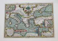
1606M8988Antwerp c.1606. Very Good. Notes: English text on verso. Size : 341x495 mm 13.43x19.49 Inches Coloring: Original Hand Coloring Reference: Van den Broecke 226. Category: Maps Mediterranean Sea; Maps Asia Near East Turkey; Maps Europe Greece Macedonia; Maps Europe Italy; unknown
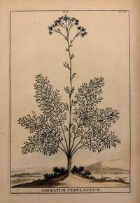
1696211441Leyden and Utrecht: Pieter Vander Aa 1696. unbound. very good. Botanical. Copper plate engraving with hand coloring. Image measures 12.5" x 8.25".<br/> <br/> Abraham Munting 1626-1683 taught medicine and botany at the Academy of Groningem in the Netherlands. He had a particular interest in the uses of plants especially medicinally. This engraving is from "Naauwkeurige Beschryving Der Aardgewassen". Aging around edges. Please visit our gallery for more Munting prints.<br/> <br/> Pieter Vander Aa unknown
162451428Köln Ioannis Gymnici Antonius Boetzer 1624 a. 1621-1640. Folio. 40 x 26 cm. Bound in 8 thick uniform contemporary full pigskin bindings over wooden boards. Raised bands and richly blind-tooled boards. Title labels with gilt lettering. Clasps missing. Spines a bit rubbed. Wear to some spine-ends. Some upper compartments with nicks one volume having a tear in leather at upper compartment. One volume with a small loss of leather to upper compartement. With engraved title-page engraved portrait of Baronius engraved portrait of pope Urban VII. More than 10.000 pp. Printed in double-columns. In general internally fine. <br/><br/><em>Baronius's monumental work with its continuation by Bzovius up to the year 1565 hailed by Roman Catholic writers as the greatest history of the church ever written and Baronius hailed as the "father of ecclestical history" 1-12 dealt with Anno 1-1198 and volume13 -20 Anno 1198-1565."The Annales were first published between 1588 and 1607. This work functioned as an official response to the Lutheran Historia Ecclesiae Christi History of the Church of Christ. In that work the Magdeburg theologians surveyed the history of the Christian church in order to demonstrate how the Catholic Church represented the Antichrist and had deviated from the beliefs and practices of the early church. In turn the Annales fully supported the claims of the papacy to lead the unique true church."Before Baronius was appointed Librarian of the Vatican in 1597 he had access to material and sources in its archives that were previously unpublished or unused. He used these in the development of his work. Accordingly the documentation in Annales Ecclesiastici is considered by most as extremely useful and complete. Lord Acton called it "the greatest history of the Church ever written"."Graesse I 296. - Brunet I 662-631. </em> hardcover
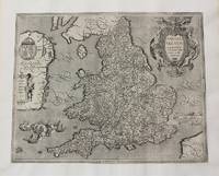
1603M10773Antwerp Belgium c.1603. Very Good margins extended. Notes: Important map of United Kingdom by Ortelius based on an earlier map by Christopher Saxton in 1579. Size : 384x483 mm 15.12x19.02 Inches Coloring: Hand Colored Category: Maps Europe United Kingdom England; Maps Europe Ireland; Maps Europe United Kingdom Wales; unknown
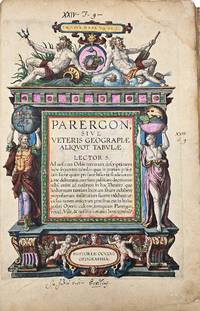
160312720Antwerp Jan Baptist Vrients 1603. Parergon sive veteris geographiae aliquot Tabulae . Engraved title 33 maps of the Ancient World 2 plates with costumes and 3 views ""Tempe"" ""Daphne"" and ""Escorial"". H. 43 x W. 30 cm. / H. 16.90 x W. 11.8 inch. A fine and complete copy of the Parergon by Abraham Ortelius 1527-1598 published in Antwerp in 1603. This celebrated companion to the Theatrum Orbis Terrarum represents one of the earliest and most influential works of historical cartography. The volume contains a full suite of maps illustrating the ancient world including the Roman Empire classical Greece and Biblical regions. All maps are original contemporary hand coloured exceptionally well-preserved and vibrant throughout. The engraved title page is richly decorated with allegorical figures and classical motifs. Latin text on verso. A highly decorative and scholarly work reflecting the humanist interest in antiquity and geography. Light age toning and occasional marginal wear are consistent with age. Overall a very attractive copy. Antwerp, Jan Baptist Vrients unknown
166472500Amsterdam: Dancker Danckertsz. 1664. 163 cm. vellum. 2 white frontispiece840 frontispiece 41-172title175-288 pp. 1 unnumbered textplate opposite page 153 157 numbered plates with plate 156 present twice probably because the accompanying text for this plate needs 2 pages. Bound with: frontispiecetitle3-32frontispiece25-6433-72 2 white pp. Pagenumbers 25-32 used twice so after the second frontispiece or page 32 pagenumbers are incorrect. 32 plates 1 folding. A good and complete copy though with some signs of use page edges and some browning of most plates. See pictures Dancker Danckertsz. hardcover
1696324019Leyden and Utrecht: Pieter Vander Aa 1696. unbound. Botanical. Copper plate engraving with hand coloring. Image measures 12.25" x 8"<br/> <br/> Lovely image of a flowering Ageratum plant with a simple distant landscape depicted in the background. Abraham Munting 1626-1683 taught medicine and botany at the Academy of Groningem in the Netherlands. He had a particular interest in the uses of plants especially medicinally. This engraving is from "Naauwkeurige Beschryving Der Aardgewassen". Aging around edges and minor foxing. Please visit our gallery for more Munting prints.<br/> <br/> Pieter Vander Aa unknown
161230987Antwerp: Balthasar Moretus 1612. Other. In excellent condition. 338 by 488mm 13 by 19 inches. Original copper engraving published 1612 in the famous historical Atlas Parergon Latin text-edition by Abraham Ortelius. Finely later hand-colored in wash and outline. Very decorative map of North Africa Libya and Tunisia with Malta and southern Sicily.This map is ornated with a decorative title cartouche in the upper right corner and an inset with text cartouches in the lower left corner. Villages and towns are shown as miniature views. Ortelius was born on 14 April 1527 in the city of Antwerp which was then in the Habsburg Netherlands modern-day Belgium. The Orthellius family were originally from Augsburg a Free imperial city of the Holy Roman Empire. In 1535 the family had fallen under suspicion of Protestantism. Following the death of Ortelius's father his uncle Jacobus van Meteren returned from religious exile in England to take care of Ortelius. Abraham remained close to his cousin Emanuel van Meteren who would later moved to London. In 1575 he was appointed geographer to the king of Spain Philip II on the recommendation of Arias Montanus who vouched for his orthodoxy. He travelled extensively in Europe and is specifically known to have traveled throughout the Seventeen Provinces; in southern western northern and eastern Germany e.g. 1560 15751576; France 15591560; England and Ireland 1576; and Italy 1578 and perhaps twice or thrice between 1550 and 1558. Beginning as a map-engraver in 1547 he entered the Antwerp Guild of Saint Luke as an illuminator of maps. He supplemented his income trading in books prints and maps and his journeys included yearly visits to the Frankfurt book and print fair where he met Gerardus Mercator in 1554. In 1560 however when travelling with Mercator to Trier Lorraine and Poitiers he seems to have been attracted largely by Mercator's influence towards the career of a scientific geographer. Wikipedia Broe. 218 Koemann III map 8610H:31 ed. 31:051 1595 Latin Balthasar Moretus unknown
1673ABC_46764The Hague: Jan and Daniel Steucker 1673. 17th- or 18th-century calf gold-tooled spine with a red morocco title label lettered in gold blind-tooled triple fillet frame on both boards gold-tooled board edges and turn-ins red edges marbled endpapers. 4to. With 10 finely engraved scenes on the horrors of war on 8 folding/double-page plates. Further with a woodcut device on the title page and a woodcut tailpiece on the final page. First edition of a famous Dutch history book vividly describing and depicting the cruelties of war committed by the French army of Louis XIV in The Netherlands in the years 1672 and 1673. The illustrations also rank among the best masterpieces of Baroque book-illustration. By their passionate denunciation of the horrors of war Romeyn de Hooghe's illustrations stand comparison with Goya's Desastres de la Guerra. Thieme & Becker calls the artist "the most important and fertile master of the second half of the 17th century in Holland". And Furstenberg judged the present print-series "One of the few and too-little known masterpieces of the period" The Book Collector 1960 p. 432.'The text includes a detailed account of the cruelties committed by the French army of Louis XIV in the Dutch villages of Bodegraven and Swammerdam. The work was published anonymously because the author Abraham de Wicqefort 1598-1682 a diplomat and politician was well-known in Paris and at the French court. He also wrote an excellent manual for ambassadors L'Ambassadeur ses fonctions published in The Hague in 1682. The present work became popular in The Netherlands and was several times republished in Dutch with the plates reduced.With a manuscript note on the recto of the final flyleaf. Slightly foxed throughout the two double-page plates loose. Otherwise in very good condition.l Hollstein Dutch & Flemish IX pp. 90-96 only 7 plates; Landwehr De Hooghe Book Illustrator 30; STCN 851219519; Van Nierop Grabowsky etc. Romeyn de Hooghe 1673.19; Willems Les Elzevier 1874 note. Jan and Daniel Steucker], hardcover
167376SED10JGA06The Hague 1673. 4to. Jan and Daniel Steucker Contemporary vellum with the gold-stamped and crowned initials "E.F.V.D" on the front board. With 10 scenes on the horrors of war on 8 folding engraved plates ca. 31 x 20 cm by Romeyn de Hooghe. 1 1 blank 202 pp. First edition of a famous Dutch history book vividly describing as well as depicting the cruelties of war committed by the French army of Louis XVI in The Netherlands in the years 1672 and 1673. The illustrations also rank among the best masterpieces of Baroque book-illustration. By their passionate denunciation of the horrors of war Romeyn de Hooghe's illustrations stand comparison with Goya's Desastres de la Guerra. Thieme & Becker calls the artist "the most important and fertile master of the second half of the 17th century in Holland". And Furstenberg judged the present print-series "One of the few and too-little known masterpieces of the period The Book Collector 1960 p. 432.''The text includes a detailed account of the cruelties committed by the French army of Louis XIV in the Dutch villages of Bodegraven and Swammerdam. The work was published anonymously because the author Abraham de Wicqefort 1598-1682 a diplomat and politician was well-known at Paris and the French court. He also wrote an excellent manual for ambassadors: "L'Ambassadeur ses fonctions" published at The Hague in 1682. The present work became popular in The Netherlands and was several times republished in Dutch with the plates reduced.Back hinge loosening. Fine large paper copy with contemporary manuscript owner's entry on the title page. Otherwise in good condition.l Hofer Baroque Book Ill. plate 140; Hollstein Dutch & Flemish IX pp. 90-96 only 7 plates; Landwehr De Hooghe Book Illustrator 30; Nierop Grabowsky etc. Romeyn de Hooghe 1673.19 p. 263; STCN 851219519; Thieme & Becker XVII p. 458; Willems 1874. hardcover
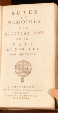
1680FGN11-F-27Amsterdam: La Haye 1680. Vellum. Very Good. 6" by 3.5". None. A rare collection of 17th century diplomatic texts treatise negotiation and correspondence. This work provides important original sources and contemporary accounts of the Treaties of Peace of Nijmegen Négotiations de Nimegue or Négotiations de la Paix de Nimègue; Friede von Nimwegen. These series of treaties signed in the Dutch city of Nijmegen between August 1678 and December 1679 ended various interconnected wars among France the Dutch Republic Spain Brandenburg Sweden Denmark the Prince-Bishopric of Münster and the Holy Roman Empire. Text in French. Second edition. Scarce. In a full vellum binding with title inked on the spine. Externally sound with marks to boards. Internally firmly bound. pages are remarkably bright and clean for their age with the few handling marks or small spots confined to the endpapers. Front pastedown has a faded and partially removed ink inscription. Very Good La Haye hardcover
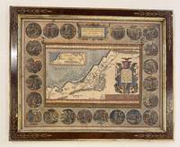
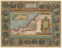
1603328971Antwerp: Ortelius Abraham 1603. unbound. Map. Engraving with hand coloring. 17 3/8 x 21 1/2" Framed in Eli Wilner carved frame.<br/> <br/> Beautiful map of the Holy Land bordered by 22 medallions depicting Abraham's wanderings. An inset map shows the path Abraham took. Ortelius used both Ptolemy and the Bible as sources for the map and based the medallion scenes on drawings by Maarten de Vos also of Antwerp. Latin text on verso. Expert repair to lower margin minor scattered stains in margins. Abraham Ortelius 1527 - 1598 a Flemish cartographer and geographer is widely regarded as one of the important and influential cartographers in history. He is known for his "Theatrum Orbis Terrarum" which was the first modern atlas. Van den Broecke 183.2 1603Lv; Laor 547C. Antwerp 1603<br/> <br/> Ortelius, Abraham unknown
161230715Antwerp: Balthasar Moretus 1612. Other. A very strong impression. In excellent condition. 353 by 457mm 14 by 18 inches. Original copper engraving published 1612 in the famous historical atlas Parergon Latin text-edition by Abraham Ortelius. Finely later hand colored in wash and outline. The map shows the travels and life of Abraham. More else this highly decorative map is surrounded by 22 fine engraved medallions which are showing episodes of the life of the Patriach Abraham. The map was published 1592 for the first time in Abraham Ortelius edition of theTheatrum Orbis Terrarum. Ortelius who created this map used as cartographical source for this map information from Ptolemy and from the bible particulary for the illustrations of Abrahams life depicted in 22 medallions. Broe. 182 Balthasar Moretus unknown
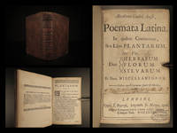
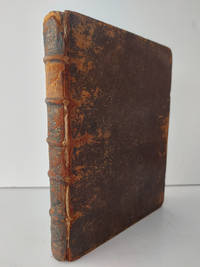
166816395<p><b>1668 HERBAL Abe Cowley English Poetry Thomas Sprat London Plants Herbs Botany</b></p><p>Abraham Cowley was one of the leading English poets during the 17th-century. Cowley wrote poems on a variety of subjects most famously an '<i>Ode to Pindar'</i>. These poems many of which were written about flowers and agriculture were published throughout his lifetime as well as frequently republished following his death in 1667. This 1668 edition of the works of Cowley includes a life of Cowley by Thomas Sprat the editor of this edition.</p><p>Item number: #16395</p><p>Price: $550</p><p>COWLEY Abraham</p><p><b><i>Abrahami Couleij Angli poemata Latina : in quibus continentur sex libri plantarum viz. duo herbarum florum sylvarum et unus miscellaneorum.</i></b></p><p>Londini : Typis T. Roycroft impensis Jo. Martyn 1668.</p><p><br /></p><p><u>Details</u>: </p><p>· Collation: Complete with all pages</p><p>o 34 420 i.e. 416</p><p>o Pagination errors as expected</p><p>· Language: Latin </p><p>· Binding: Leather</p><p>o Visible repair at inner hinges</p><p>· Size: ~7in X 4.75in 18cm x 12cm</p><p>Our Guarantee:</p><p>Very Fast. Very Safe. Free Shipping Worldwide.</p><p>Customer satisfaction is our priority! Notify us with 7 days of receiving and we will offer a full refund without reservation!</p><p>16395</p><p>Photos available upon request. </p> T. Roycroft, impensis Jo. Martyn hardcover
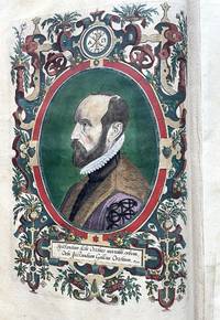
160312725Antwerp Jan Baptist Vrients / Robert Brunaeu 1603. Theatrum orbis terrarium followed by Parergon sive veteris Geograpiae aliquot tabulae followed by Nomenclator Ptolemaicus. Complete copy bound in a contemporary vellum binding stamped with multiple friezes on the covers and 5 raised bands on the spine 358 f. Folio. Illustrated edition with an engraved allegorical frontispiece the arms of the Kingdom of Spain on the verso an engraved portrait of Ortelius an architectural frontispiece Parergon and 156 engravings. including 151 engraved maps 33 of which are in the Parergon as well as 3 plates of views and 2 plates of costumes. Some pages of the text are foxed and the stamp has been scratched off on the title page. Restoration work at the bottom of the two costume plates. Reinforcement in the margin of the inner hinges of 7 maps. H. 46 x W. 32 x D. 10 cm. / H. 18.11 x W. 12.6 x D. 3.94 inch. The finest edition of this iconic atlas considered to be the first true atlas the first true atlas Van der Broecke. ""The unique place occupied by Ortelius' Theatrum in the history of cartography is mainly due to its status as the world's first regularly produced atlas . Its form and content set the standards for subsequent atlases"" Koeman 1969 III 29. Ortelius' atlas was revolutionary because it was the first attempt to present the geography of the world in a uniformly produced collection of maps of all known parts of the world. Ortelius designed the maps himself basing his designs on the cartographic sources that he had at hand and equally revolutionary also mentioning his sources on the maps and once finished had them engraved by Frans Hogenberg and Ambrosius and Ferdinand Aertsen. Finally Gielis Coppens van Diest printed the maps after which they could be coloured also in a uniform style and bound in a logical order in one volume. These atlases were a new phenomenon and proved to be very popular in Europe. Soon editions were published in various languages of Europe in print runs of a few hundred copies each. A perfectly complete copy of the Theatrum Orbis Terrarum the Parergon and the Nomenclator Ptolemaicus in its original colours. Literature: Van de Krogt/ Koeman IIIA 31:053; Adams O-335; Phillips 382; Shirley 122 Antwerp, Jan Baptist Vrients / Robert Brunaeu hardcover
16855057Benjamin Tooke 1685. Second Edition. Hardcover. Used - Good/None. Spine binding and cover fine and robust; corners turning in and exposed slightly and scuff marks on front board. Slight crack between front board and spine spine worn at top; five raised bands on spine spine cover missing in one section. Contents clean with inscription on inside cover. Overall very good and clean copy. 267 pages. Benjamin Tooke hardcover
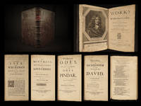
166818089<p><b>1668 1ed Abraham Cowley English Poetry Mistress Motto Pindar Ode Davideis Sylva</b></p><p><i>"What shall I do to be for ever known</i></p><p><i>And make the Age to come own"</i></p><p><i>I shall like beasts or common people die </i></p><p><i> Unless you write my elegy." </i>– Abraham Cowley <i>The Motto</i></p><p>Abraham Cowley was one of the leading English poets during the 17th-century. This charming and rare sixth edition was the last edition of the original one-volume printing. Following this edition the works were printed in multiple volumes. Famous poems such as '<i>The Motto</i>' '<i>The Mistress</i>' '<i>Ode to Pindar</i>' and '<i>Davideis'</i>are all included in this collection. The Pindaric Ode is especially interesting in that Cowley attempted to reproduce Pindar's works but in doing so he misinterpreted the metrical patterns and in doing so did not accurately reflect Pindar's poetry. He did however create one of the most famous odes ever written which would become the influence for William Wordsworth's famous ode<i> "Intimations of Immortality."</i></p><p>This impressive 1668 first edition includes a biography of Thomas Spratt.</p><p>Item number: #18089</p><p>Price: $750</p><p>COWLEY Abraham</p><p><b><i>The works of Mr. Abraham Cowley : consisting of those which were formerly printed: and those which he design'd for the press now published out of the authors original copies</i></b></p><p>London: Printed by J.M. for Henry Herringman. 1668. First edition.</p><p><u>Details</u>: </p><p>· Collation: Complete with all pages</p><p>o Biography and Miscellanies – 42 41 1</p><p>o The Mistress – 80</p><p>o Pindarique Odes – 4 70 i.e. 68</p><p>o Davideis – 154 23</p><p>o Other verses and works – 148</p><p>· References: Lowndes 539; Perkin B 7.</p><p>· Language: English</p><p>· Binding: Leather; secure</p><p>· Size: ~11.75in X 7.75in 30cm x 19.5cm</p><p>Our Guarantee:</p><p>Very Fast. Very Safe. Free Shipping Worldwide.</p><p>Customer satisfaction is our priority! Notify us with 7 days of receiving and we will offer a full refund without reservation!</p><p>18089</p><p><br /></p><p>Photos available upon request.</p> J.M. for Henry Herringman hardcover
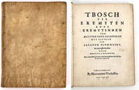
16191516Hantvverpen Antwerp: Hieronymus Verdussen 1619. First Edition in book form. Near Fine. Bloemart Abraham. 4to 8 7/8 x 6 3/4 inches 251 x 171 mm. ix pp 51 sheets on cream laid paper text in Dutch gothic letters. 50 numbered full page copperplate engravings of Christian hermit saints 25 male 25 female printed recto with text pages on verso. Full-page frontispiece for the work and with an additional full-page frontispiece for each of the two sections. Full contemporary vellum untitled with some handling discoloration but the vellum remains supple and the binding is tight. Pages clean and bright with a couple of foxing spots and a small brown stain on the 2nd frontis titled "Sacra Eremus ascetarum"; toned page edges. Previous owner's name and date in ink on front flyleaf and small pencil and ink notations inside back cover; bookplate of Buijnsters Smets pasted inside front cover.<br /> De Backer/ Sommervogel VII 194-5; Hollstein 355-403; Roethlisberger 163 ill. 262-317<br /> <br /> Full title: 't Bosch der Eremyten ende eremilinnen van Aegypten ende Palestinen met figuren van Abraham Blommaert door Ghristophorus a Sichem. Met kort verhael van een yders leven getrocken uyt het Vadersboeck door H. Jan van Gorcum Priesler ende H. R. Societatus sic Jesu. The Forest of the Hermits of Egypt and Palestine with illustrations by Abraham Blommaert engraved by Ghristophorus a Sichem. With brief stories of their lives taken from the book of the Fathers by H. Jan van Gorcum priest of the Society of Jesus. A fine series of engravings of the early Christian male and female hermits living in the Egyptian and Palestinian desert engraved in copper by Boetius A Balswert on drawings by Abraham Bloemart 1566 - 1651 the Dutch painter and engraver know mostly for his historical subjects and for being a central figure and teacher among the Utrecht Caravaggisti. <br /> Provenance: the library of the book- and art-historians Piet Buijnsters and Leontine Smets. Hieronymus Verdussen unknown
161918555<p>Very Good HC. Text in Dutch blackletter; tekst in het Nederlands gotisch. Full contemporary vellum; untitled; raised bands on spine; red edges; 50 numbered full page copperplate engravings of Christian eremite saints 25 male 25 female printed recto with text pages verso; full page frontispiece for work as well as full page frontispiece for female section. Vellum in very good condition with some handling discoloration remains supple; ties at cover fore edges lacking; tightly bound; few pencil notes on front pastedown; without free end papers; lacking frontispiece for male section leaf A!; facsimile laid in; few leaves with light damp stains or soiling mostly in margins otherwise light and clean interior; one leaf B3 with large chip at top fore corner not affecting portrait but with some text missing from marginal notation on verso see photo; all leaves remain supple. 25 x 18 cm; 51 text pages; 50 numbered plates 2 frontispiece plates; in 4s. Ref OCLC #901301549.</p> Hantvverpen (Antwerp): Hieronymus Verdussen hardcover