Ortelius, Abraham:Biblio.com
Ortelius, AbrahamBiblio.com
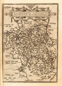
Waldeccensis Comitatus Descriptio Accuratissima Waldeccensis Comitatus Descriptio Accuratissima - Abraham Ortelius ∑ Hand-Colored Original Copperplate Engraving ∑ Antwerpen 1608
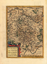
160811191Antwerpen: Juan B. Vrients 1608-12. In sehr gutem Erhaltungszustand. 31.3 x 223 cm 12.25 x 875 inches. Hand-Colored Original Copperplate Engraving by Abraham Ortelius depicting Waldeccensis Comitatus Descriptio Accuratissima. Published Antwerpen Juan B. Vrients 1608. Sheet: 31.3 x 223 cm 12.25 x 875 inches. A fine and original hand-colored example of Ortelius's celebrated cartographic work documenting this region of Germany with the precision and decorative artistry characteristic of the 16000s. Abraham Ortelius 1527-1598 was a Flemish cartographer and geographer from Antwerp widely regarded as the creator of the first modern atlas. His landmark publication Theatrum Orbis Terrarum 1570 set the standard for atlas-making for the next century presenting uniform copper-engraved maps with scholarly commentary. By Ortelius's death the Theatrum had appeared in 25 editions in seven languages. In 1575 King Philip II of Spain appointed him Royal Geographer. His maps engraved with extraordinary precision are among the most sought-after in antique cartography held in collections including the Plantin-Moretus Museum in Antwerp the Library of Congress and the British Library.This original copperplate engraving with original hand coloring depicts the region of Waldeccensis Comitatus Descriptio Accuratissima published in Antwerpen Juan B. Vrients 1608-12. The map records the political and geographic boundaries of the region as understood in 1608-12 offering a fascinating window into the history of German territorial organization. Sheet measures 31.3 x 223 cm 12.25 x 875 inches. In good condition overall with minor signs of age appropriate for a 17th-century engraving. Minor defects: centerfold as issued. Ready to frame. Broe. 98b; Juan B. Vrients unknown
Antiquariat Reinhold Berg ek · Allemagne125,00 $US≈ 105,76 €