19 171 résultats
201216852Paris, Découvertes gallimard, 1986 ; in-12, 224 pp., br.
200916474Paris, Découvertes gallimard, 1986 ; in-12, 224 pp., br. (écorné usagé).
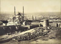
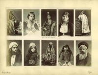
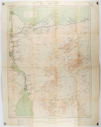
186985507h<p>London: Illustrated London News 1869. Book. Near Fine. Hardcover. Folio - over 12 - 15" tall. Half-year run bound in early half-leather over pebbled cloth boards. Some edge-wear and bumping to covers; small paper label painted over to upper spine. Edges toned and old library bookplate and marks to front and rear endpapers. Front hinge nearly exposed internally at endpaper but still firm. Otherwise clean tight and unmarked. Very neat -- a sound and handsome volume and internally unusually bright and clean. Superb illustrations.</p> Illustrated London News hardcover
201315336Paris, Plon, 2009 ; in-8, 415 pp., broché . Très bon état.
616611884. . Albumen print. Rich dark tones and in good condition.<br /> <br /> 1884]. unknown
63737c.1880. . Albumen print pasted on original card. Good tonal range and in good condition manuscript title on card. Dimension: 200 x 290mm. 8 x 11.5 inches.<br /> <br /> c.1880]. unknown
1920195120London.: War Office. 1920. Folding colour map mounted on linen 83.5 x 63cm; 93.3 x 73cm a few small fold splits no loss but in very good condition. A single sheet from the British War Office topographical map series covering the area around the Egyptian city of Port Said and the northern section of the Suez Canal. Shows the Mediterranean Sea coastline forts coast guard barracks and stations built-up area in Port Said breakwaters gas and electricity station petroleum tanks water works customs house quarantine station Admiralty House Suez Canal Company office Port Said Salt Company area other populated places road railway and stations post and telegraph offices police station at Mataria ruins the Suez Canal from Port Said south to Tina station Lake Manzala wetland and sand areas. Includes legend and general notes on terrain. . War Office. unknown
1861177021Edinburgh & London.: William Blackwood & Sons. 1861. Engraved map with original outline hand-colour 57 x 43.8 cm 61.1 x 49 cm sheet central fold very slight edge toning but the map in very good bright condition. First edition. Fine large folding map: the Nile delta and river with attractive original outline colour railways and canals marked and name references to biblical and classical geography. Published for inclusion as map 39 in "Keith Johnston's royal atlas of modern geography" . William Blackwood & Sons. unknown
1833174939London.: Published for the Proprietors by Mr. Bull. 1833. Engraved map 14.1 x 8.8 cm original hand colour in very good condition. Fine miniature map with appealing hand colour denoting Lower Central and Upper Egypt. . Published for the Proprietors by Mr. Bull. unknown
1803174955London. circa1803. Engraved map 23 x 18.5 cm original folds small split to one fold affecting the margin only paper age- toned lower corner darkened and on the verso inked circles to the lower half in an early hand but in good condition. Finely engraved early 19th Century map also showing to the north Syria Palestine and Cyprus and Darfur and Mountains of the Moon Sources of the Nile to the South. . unknown
1880174937London Edinburgh & Glasgow.: William Mackenzie. 1880. Map printed in colour with original outline hand colour 29.8 x 22.7 cm central fold edge toning but in very good condition. Published for inclusion in "The National Encyclopaedia: A Dictionary of Useful Knowledge". . William Mackenzie. unknown
1875ABC_46596Egypt 1875. A single oblong board 30 x 40 cm. Zangaki brothers 2 albumen photographic prints mounted on one board 1 on each side approx. 225 x 28 cm. 2 albumen photographic prints of a view of the Nile with pyramids in the background and the Al-Azhar mosque in Cairo by the Zangaki brothers "Adelphoi Zangaki" who were two photographers of Greek origin active in Egypt from ca. 1870 until the beginning of the 20th century. They can be grouped together with other commercial photographers who worked in Egypt during the second half of the 19th century. These photographers such as Félix Bonfils Gustave le Gray and others who were mostly of French origin were able to capitalise on the rising demand for photographic prints as souvenirs. Photographers like the Zangaki brothers often sold the albumen prints from their studios located in cities like Port Said Cairo and Suez but produced the actual photographs using the collodion process in a portable darkroom - a cart or sometimes even a boat - in the field.The brothers were quite prolific producing at least 1500 photographs of Egypt and other regions of the Middle East during the span of a few decades around the turn of the 20th century. Since these photographs were taken with the purpose of creating prints for tourists the subjects are often "quintessentially Egyptian" and sights such as the pyramids along the Nile river are captured. However they also provide a glimpse into Egyptian daily life or occasionally one can sneak a peek at one the photographers and their portable darkroom. Not much is known about the Zangaki brothers and until quite recently people thought that the photographic prints signed "Zangaki" were produced by one single person. With a tear in the lower margin not affecting the photographs some foxing remnants of white tape to one of the side margins of the board with a small blue ink mark below an inscription "Mosque of El Azhar." in the margin below the photograph of said mosque. Overall in good condition.l cf. Erdem Views of Egypt by Georgios and Constantinos Zangaki . 2009; Hannavy in: Encyclopedia of Nineteenth-Century Photography p. 1521; Perez Focus east p. 233. ABE CAT Art History ABE CAT Middle East Arabian Peninsula unknown
19696475[Le Caire, 6 août 1969]. 1969 1 vol in-plano ( 595 x 425 mm) de: 5 ff imprimés en rouge et noir. (déchirure sans manque de quelques cm sur les deux dernières feuilles, oxydation du papier). Demi-maroquin vert de lépoque, titre et date frappés à l'or en arabe au plat supérieur.
1959206788Cairo.: State Tourist Administration; Institut Graphique Egyptien. 1959. Folding pictorial colour map 47.5 x 43.8 cms; 51.7 x 47.7 cms sheet folding into plain title wrappers 21 x 12 text in panels on verso in very good bright condition. Brightly coloured tourist map of Egypt and the Middle East with pictographs of various tombs temples oases and wildlife roads and railways. Information for the tourist about Egypt and Syria including a brief history hotels transport health and currency are printed on the verso. . State Tourist Administration; Institut Graphique Egyptien. unknown
189164118London: George Routledge and Sons 1891. 8vo. xxvii 1 499 1 pp. Illustrated title page frontisp. w/ original tissue guard over 70 woodcut text engravings. Brick-red pictorial publisher’s cloth gilt illustrated borders of camel & pyramids gilt gray & black lettering very minor chipping head of spine minor edgewear slight scuffing still a VG bright copy w/ former ownership markings on endpapers. Second edition revised of this informative and well-illustrated work on her travels through Egypt and Egyptology by the famed Victorian Egyptologist world traveler journalist and author. Edwards 1831-1892 sailed a dahabiyey up the Nile to Abu Simbel and spent six weeks excavating at the Temple of Rameses II and writes against the pillaging and destruction of tomb looters. George Routledge and Sons, hardcover
193853557Alexandria Egypt: W.F. Nicholson Northern Assurance Co. Ltd. Egypt & Near East Branch 1938-1939. Oblong 4to. 12.5 x 9.75 in. 48 pp unpaginated. thick black paper stock w/ 177 black & white silver gelatin photos on glossy photo stock tipped-in sized from 2.5 x 3.5 in. up to 4 x 6 in. with nearly all including white ink captions below or on the sides white ink manuscript for title page. Contemporary embossed & padded simulated leather post-binder album painted embossed cover illustration of Ancient Egyptian figures leading bulls papyrus reeds sewn into fore-edges with some loss rounded corners minor edgewear rubbing wear to corners still a VG- exemplar. This excellent photo album documents the trip of a Northern Assurance Co. Ltd. insurance executive to their Egypt & Near East Branch office in the Fall of 1938 to 1939. Nicholson fl. 1920-1940 begins with photo images of the voyage off France Italy & Sicily to Egypt in the Tyrrhenian Sea on the P&O RMS Cathay with images of Stromboli the Chateau d’If Marseilles and shipboard passengers. These are followed by photos of the arrival in Port Said the stay in the historic Eastern Exchange Hotel now demolished street scenes in the native quarters the harbor piers lighthouse views of the Suez Canal and more. Included as well are photos of mosques and monuments in Port Said street and water scenes in Ismailia a trip through the desert to an oasis by Alexandria in a 1932 Ford Coupe with views of camels and the car in the market his arrival in Alexandria as well as the interiors of the company offices on 33 Rue Cherif Pasha in Alexanderia. There are many photos of Alexandria including the Royal Palace the College of Saint Mark the Strand the Mahmoudieh Canal street scenes gardens and more. The album closes with views of Cairo the museum Zuwela Gate the Citadel built by Saladain the Mameluk Tombs funeral procession Nilebride boat many of the pyramids and Tutankhamen’s Tutankhamun treasures in the Cairo museum. The Northern Assurance Co. was founded in 1836 as the North of Scotland Fire and Life assurance Co. renamed in 1848 and by the early 20th century had become a specialty company in the marine insurance and shipping insurance business and had established their Alexandria Egypt branch office in 1855. See: Northern Assurance Co. Ltd. fl. 1836-1968 Univ. of Aberdeen Special Collections. W.F. Nicholson, Northern Assurance Co. Ltd., Egypt & Near East Branch, hardcover
1942207841London.: Royal Engineers. July1942. Printed colour topographical map mounted on linen 56.7 x 79.2 cms; 64.6 x 89. 5 cms sheet original folds edgewear small marginal chips a little dusty but in good condition. Detailed World War II operational map of Egypt and the Middle East issued by 512 Army Field Survey Company of the Royal Engineers. The map is marked "Not to be Published" in the upper right margin. Railways roads camel tracks telegraph lines boundaries altitudes towns and villages are marked. . Royal Engineers. unknown
191125928London: Egypt Exploration Fund 1911. Thirty-First Memoir 1911. Hardcover. Used-Very Good. London: Egypt Exploration Fund, 1911. Thirty-First Memoir hardcover
190725924London: Egypt Exploration Fund 1907. Twenty-Eight Memoir 1907. Hardcover. Used-Very Good. London: Egypt Exploration Fund, 1907. Twenty-Eight Memoir hardcover
1900216690Bolton & London.: Tillotson Press. N.d. c1900. Souvenir album of 70 black and white photographic plates with captions in English German and French. Green cloth covered boards lettered in gilt with bright gilt stamped device decorated endpapers covers worn with considerable insect damage to cloth covering the boards internally clean tight and unmarked. 20 x 26cm. . Tillotson Press. hardcover
190637681Washington D.C.:: n.p. 1906. First edition. Stapled paper wrappers. A very good copy with minor edgewear to wrappers. 92 pp. Illus. with 1 b/w in-text drawing. 8vo. 59th Congress 1st Session. Senate. Document No. 104. "Cope Whitehouse was a rich New York lawyer who spent his private fortune on his amateur work as a passionate "Egyptologist" not only conducting archaeological digs in the Middle East but receiving international acclaim for his humanitarian efforts to "regulate" the water supply from the River Nile in times of drought." He discovered the depression in the Egyptian desert known as the Wadi Raiyan 1882 and wrote many papers advocating it as a storage reservoir as noted in this report. OCLC locates only three hard copies: Linda Hall Forschungsbibliothek Gotha Univ. Liverpool. Irrigation: A Selected Bibliography p. 409. n.p. unknown
188033358Probably Cairo: Probably Maison Bonfils ca. 1880. With 56 full page albumen photographs mounted on board and with descriptions lettered by hand on the boards beneath the images. 210 x 270 mm. the mounted photographic images approximately 195 x 250 mm. the photographs are housed in a folding protective binder of brown calf the covers with triple gilt fillet rules the spine and upper cover with dark brown lettering labels gilt the inner portions of the foldover binding are decorated with patterned papers of red green and cream. 56 photographs on 28 boards the photographs in sepia. A very well preserved set with normal age and fading. A FINE COLLECTION OF PHOTOGRAPHS OF EGYPT including street scenes landscapes architecture photographs of mosques and tombs of the pyramids and ancient monuments and of people gathered in groups in Cairo and of Bedouin Arabs in gatherings and alone. Maison Bonfils was a French family-run company producing and selling photography and photographic products from Beirut then in Ottoman Syria now in Lebanon from 1867 until 1918 from 1878 on renamed "F. Bonfils et Cie". The Bonfils ran the first and in their time most successful photographic studio in the city. Maison Bonfils produced studio portraits staged biblical scenes landscapes and panoramic photographs. <br> Félix Bonfils a French photographer married Marie-Lydie Cabanis in 1857. The couple together with their son Adrien moved to Beirut in 1867 where they opened a photographic studio called "Maison Bonfils" on what later became rue Georges-Picot. Maison Bonfils produced thousands of photographs of the Middle East. Bonfils worked with both his wife and his son. They photographed landscapes portraits scenes with subjects dressed in Middle Eastern regalia and also stories from the Bible.<br> Félix Bonfils took photographs in Ottoman Syria in today's Lebanon Syria Israel & Palestine the Khedivate of Egypt Greece and Constantinople producing the vast majority of his work while his wife and son were also involved in photography produced by the studio. As few are signed it is difficult to identify who is responsible for individual photographs. Lydie is thought to have taken some of the studio portraits especially those of Middle Eastern women who were more inclined to pose for a female photographer. In 1876 Félix returned to AlÄs to have compiled collections of their photographs published.<br> In 1878 when the name of the studio was changed to "F. Bonfils et Cie" Adrien was back in Beirut after completing his studies in France and took more responsibility for photography including landscape. Félix again travelled to AlÄs to establish a collotype printing factory in 1880 and died there in 1885. Probably Maison Bonfils hardcover
190073681London: Bernard Quaritch 1900. First Edition. Hardcover. Near fine. London Bernard Quaritch 1900. Octavo viii 64 pages with approximately 500 illustrations plus 16 plates substantially reproducing the text illustrations and a frontispiece. Pictorial cloth very lightly marked and rubbed; edges slightly foxed; endpapers offset; a near-fine copy. Fraser's collection comprised some 475 scarabs and cylinders. Bernard Quaritch hardcover
180260653London: W. Bulmer & Co. for G. & W. Nicol 1802. First U.K. Edition. First printing. Quarto 27cm. Contemporary sprinkled calf gold roll around outer perimeter of boards board edges tooled in blind titled in gilt on red leather spine label; plain endpapers; ivxxvi1951pp with postscript leaf paginated "188" inserted after p.188; 3 maps 2 folding with routes traced in color compiled by J. Rennell and engraved by J. Walker. Bookplate of John Bacon Lawrey Morritt Rokeby Park. Sound and clean mild rubbing to board edges spine leather dry and cracking internally with a few scatted spots of foxing one folding map with small tear at center fold but otherwise Very Good. Collated and complete. <br /> <br /> First English translation of Hornemann's travels previously published in German Weimar 1801. Hornemann a student at Göttingen was "engaged by the African Association in London with instructions to reach the River Niger by crossing the Sahara from Egypt." When Napoleon's army took Cairo Hornemann managed to gain Napoleon's patronage for his journey. He joined a caravan heading toward Marzuq and visited several oases before turning north to Tripoli. There he "sent despatches back to London" then joined a caravan heading south and disappeared. Later information suggested that he had successfully crossed the Sahara but died of dysentery just north of the Niger. HOWGEGO I H100. W. Bulmer & Co. for G. & W. Nicol unknown
1894LV2689Cairo Egypt: 1894. 1894. 2 volumes. 23; 19 ff. 160 original photographs vol. I; 120 original photographs vol. II. Each photo measures 4.5 x 35 inches; many photos are faded whereas others are strong a couple of photos were defaced with ink doodles. Original full brown morocco with tooling with the title "SNAPSHOTS EGYPT 1894 – VOL. I & II". Very good condition. 280 PHOTOGRAPHS RECORDING A VISIT TO EGYPT IN 1894: Each photograph is carefully labeled and annotated in ink English. The album records photographically the touring holiday in Egypt from arrival to departure of an unnamed older man husband and two women related who record scenes from Alexandria to the monuments in Gizeh Beni-Hasan Luxor Karnak Thebes Kom Ombo Assuan Shellal Mahadah Philae Wadi-Halfa and Abu-Sir. / The photographs are all the same size 4.5x3.5 inches with four pictures mounted per page. Many of the photographs have faded over time and many are well preserved. The strength of the album are the numerous images taken of the Egyptian peoples encountered in their journey including some of their guides and guards. There are a total of 280 mounted photographs by far the greater number are carefully annotated with inscriptions sometimes rather candidly. Approximately three photographs are defaced with child-like doodles. This is a rich resource of original unique photographs all taken during the three-some's 1894 journey from England to Egypt. The names of the tourists an older bearded man 2 ladies – seem to be related is never mentioned. A list of the photo titles is also available. 1894. unknown