HARTUNG, Johann ChristophAntiquariat.de
MERCATOR (Gerard);HONDIUS (Jodocus);Livre Rare Book
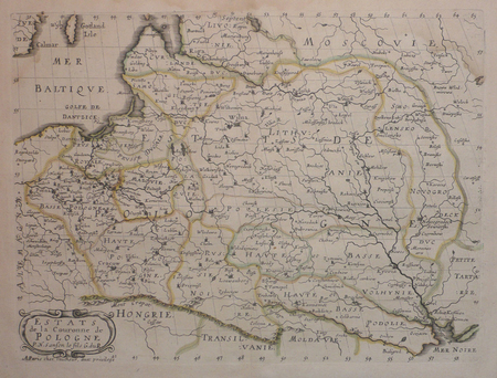
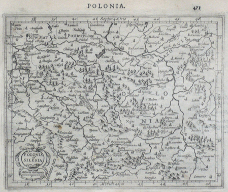
Polonia et Silesia.
1610LBW0616bDordrecht Adrianus Bottius 1610 149 x 177 mm.
Librairie Le Bail · Paris, France200,00 €
14 résultats
1684603619Jena, Witwe S. Schmid, 1684. 4to. 36 S. Geheftet.
16884568Parme chez Juan Batanar 1688 Un volume in-12 plein veau d'époque, dos à nerfs orné, 120 pages. Manques aux coiffes, légère trâce de brûlure en marge des derniers feuillets, sans atteinte au texte.
1661LBW0253c[1661]. 104 x 126 mm.
165580791655 in-4, 8pp., demi-rel. bas. mod. Wien (?) 1655,
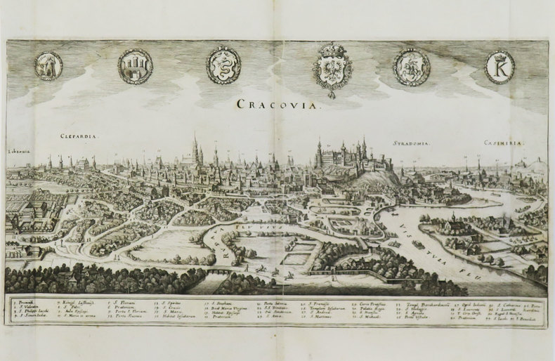
165580781655 demi-rel. mod. in-4, 4pp., papier uniformément bruni, Cracoviae 1655,
165680841656 in-4, 35pp., demi-rel. bas. mod. Helmstadt Henningus Müller 1656,
1610LBW0616bDordrecht Adrianus Bottius 1610 149 x 177 mm.
1657LBW0418dParis chez l'autheur 1657 191 x 253 mm.
1663533CLAELZRAdrian Viacq The Hague for Pierre du Marteau Cologne: 1663. 1663 pp. 239; 168; 120; 192. French text. Lightly foxed. 24mo. 124 x 72 mm. Later full leather gold binding. Leather doublures. Boards detached. All edges gold. The pagination mix in this copy does not appear to conform to any other edition that has been bibliographically described. See: Willems 868 / 1305 / & 1317; Brunet IV:145. Henry III 15511589 was King of France from 1574 until his death as well as King of Poland and Grand Duke of Lithuania from 1573 to 1575. RARE. PRICE JUST REDUCED! SMALL BOX 2 Language: eng. Hardcover. Very Good. (Adrian Viacq, The Hague) for Pierre du Marteau, Cologne: 1663. hardcover
1603LBW02528[Anvers, 1603]. 344 x 420 mm.
1644200051AG1644. Amsterdam Blaeu 1644. Original hand-coloured engraving. Plate Size: 50.5 cm x 41.3 cm. Sheet Size: 65 cm x 56.1 cm / With Mount: 67 cm x 58.8 cm. Original map. In very good clean condition. Latin text on reverse. Beautiful and richly detailed map of the Duchy of Glogów/ Glogau in Polish Silesia. Relief shown pictorially. The Oder River dominates the heavily-forested landscape. A large decorative title cartouche bear the coat of arms featuring Bohemian lion and Silesian eagle. Explanatory box with map keys also included. In the opposite corner another decorated cartouche contains bar scale. Willem Janszoon Blaeu 1571-1638 was a Dutch cartographer atlas maker and publisher. Along with his son Johannes Blaeu Willem is considered one of the notable figures of the Netherlandish/Dutch school of cartography in its golden age the 16th and 17th centuries. Blaeu set up his mapmaking and publishing business in Amsterdam where he sold instruments and globes published maps and edited the works of intellectuals like Descartes and Hugo Grotius. In 1633 he was appointed map-maker of the Dutch East India Company. In 1635 he released his atlas Theatrum Orbis Terrarum sive Atlas novus. Willem died in 1638. He had two sons Cornelis 1610-1648 and Johannes 1596-1673. Joan trained as a lawyer but joined his father's business rather than practice. After his father's death the brothers took over their father's shop and Joan took on his work as hydrographer to the Dutch East India Company. Later in life Joan would modify and greatly expand his father's Atlas novus eventually releasing his masterpiece the Atlas maior between 1662 and 1672. Wikipedia unknown
1658LBW-2739[Amsterdam, 1658]. 432 x 539 mm.
1649LBW-3597[1649]. 203 x 389 mm.
1657PHO-1458A Troyes, par Nicolas Oudot, et se vendent à Paris: Chez François Clousier, 1657. in-4; [6ff. (sur 7: feuillet de dédicace en fac-simile), dont titre, portrait légendé de La Boullaye, préface], 558p., [5ff. Table, fautes, privilège du 12 février 1657]; 33 illustrations sur bois dans le texte dont 16 à pleine page. Reliure d'époque en basane brune, dos à nerfs avec titre , coupes , coiffes et coins usés , frottements. un coin déchiré au titre sans atteinte au texte. Mouillure angulaire au premier portrait P. 73 déchirée avec manque de papier ,sans atteinte au texte. P. 165: manque en coin avec perte de qq mots; PP. 173 et 175: déchirures sans perte de texte; P. 234: manque de papier en pied avec perte de quelques mots; taches d'encre pp. 264 ; pp. 460 à 485: petites galeries de vers marginales en pied. Ex-libris manuscrit Dominium Antonium Biguet. Seconde édition