Scotland Court of SessionBiblio.com
2 945 résultats
1391950798.Gpaperback. Good. Access codes and supplements are not guaranteed with used items. May be an ex-library book. paperback
1396736956.Ghardcover. Good. Access codes and supplements are not guaranteed with used items. May be an ex-library book. hardcover
ria9781020445187_inpHardcover. New. New Book; Fast Shipping from UK; Not signed; Not First Edition; The Scottish Law Reporter is an essential resource for anyone interested in the Scottish legal system and the history of Scottish law. It provides detailed reports of notable cases decided in various courts including the Court of Sessi hardcover
184734314Aberdeen: Lewis Smith 1847. Folding map at front 16 1/2 x 6 inches. 1 vols. Sm. 12mo. Original light blue wrappers dated 1847 by J. Henderson Lithographer and Engraver. publisher's advertisements on back wrappers. Some discoloration rubbing with chipping of spine else very good with the signature of James Ogilvy Jun. Aberdeen. 28th June 1848 on verso of title. Folding map at front 16 1/2 x 6 inches. 1 vols. Sm. 12mo. Deeside. Lewis Smith unknown books
1939RO60111077James Nisbet & Co Ltd. 1939. In-8. Relié. Etat d'usage, Tâchée, Dos fané, Intérieur acceptable. 200 pages. Illustré de nombreux dessins en noir et blanc et en couleur, dans et hors texte. Tampons en pages de garde et de titre. Jaquette manquante.. . . . Classification Dewey : 420-Langue anglaise. Anglo-saxon
0243186673.Gpaperback. Good. Access codes and supplements are not guaranteed with used items. May be an ex-library book. paperback
0332857980.Ghardcover. Good. Access codes and supplements are not guaranteed with used items. May be an ex-library book. hardcover
ria9781018387642_inpHardcover. New. New Book; Fast Shipping from UK; Not signed; Not First Edition; This work has been selected by scholars as being culturally important and is part of the knowledge base of civilization as we know it.This work is in the "public domain in the United States of America and possibly other nations. Withi hardcover
0243279981.Gpaperback. Good. Access codes and supplements are not guaranteed with used items. May be an ex-library book. paperback
0483899747.Ghardcover. Good. Access codes and supplements are not guaranteed with used items. May be an ex-library book. hardcover
133474274X.Gpaperback. Good. Access codes and supplements are not guaranteed with used items. May be an ex-library book. paperback
1851200139AG1851. London & New York John Tallis & Company 1851. Large Original steel engraving / Vintage map. Drawn and engraved by John Rapkin. Illustrated and Engraved by D. Pound. Plate Size: 51 cm x 36.5 cm. Sheet Size: 51.5 cm x 37.2 cm. Vintage 19th century map / city-plan in very good condition. This Map is beautifully framed. Price includes worldwide free shipping per UPS Courier Framed. Published in the Illustrated Atlas And Modern History Of The World Geographical Political Commercial & Statistical Edited By R. Montgomery Martin. Handsome town-plan of Edinburgh in Scotland. The The Water of Leith can be seen running through Scotland's capital city. Railways street and district areas of the city are also included. The Salisbury Crags Carlton Hill and the Castle Rock are all shown. Decorative scrolling and title cartouche around the edges of the map. One of the few double page plans published by Tallis. The project of 'The Illustrated Atlas' was designed to be finished just in time for the anxiously awaited "Great Exhibition of the Works of Industry of All Nations" or The Great Exhibition sometimes referred to as the Crystal Palace Exhibition in reference to the temporary structure in which it was held was an international exhibition that took place in Hyde Park London from 1 May to 11 October 1851. It was the first in a series of World's Fairs exhibitions of culture and industry that became popular in the 19th century and it was a much-anticipated event. The Great Exhibition was organized by Henry Cole and Prince Albert husband of the reigning monarch Queen Victoria. It was attended by numerous notable figures of the time including Charles Darwin Samuel Colt members of the Orléanist Royal Family and the writers Charlotte Brontë Charles Dickens Lewis Carroll George Eliot and Alfred Tennyson. Music for the opening was under the direction of Sir George Thomas Smart and the continuous music from the exhibited organs for the Queen's procession was "under the superintendence of William Sterndale Bennett". Wikipedia unknown
1851200138AG1851. London & New York John Tallis & Company 1851. Original steel engraving / Vintage map. Drawn and engraved by John Rapkin. Illustrated and Engraved by H. Winkles. Plate Size: 48 cm x 36 cm. Sheet Size: 52.5 cm x 37.2 cm. Vintage 19th century map / city-plan in very good condition. Published in the Illustrated Atlas And Modern History Of The World Geographical Political Commercial & Statistical Edited By R. Montgomery Martin. Handsome town-plan of Glasgow in the West Central Lowlands of Scotland. The River Clyde can be seen running through the industrial city being joined by the smaller River Kelvin in the lower left corner. Canals railways street and district areas of the city are also included. The coat of arms of the City of Glasgow is present on the map. Decorative scrolling and title cartouche around the edges of the map. One of the few double page plans published by Tallis. The project of 'The Illustrated Atlas' was designed to be finished just in time for the anxiously awaited "Great Exhibition of the Works of Industry of All Nations" or The Great Exhibition sometimes referred to as the Crystal Palace Exhibition in reference to the temporary structure in which it was held was an international exhibition that took place in Hyde Park London from 1 May to 11 October 1851. It was the first in a series of World's Fairs exhibitions of culture and industry that became popular in the 19th century and it was a much-anticipated event. The Great Exhibition was organized by Henry Cole and Prince Albert husband of the reigning monarch Queen Victoria. It was attended by numerous notable figures of the time including Charles Darwin Samuel Colt members of the Orléanist Royal Family and the writers Charlotte Brontë Charles Dickens Lewis Carroll George Eliot and Alfred Tennyson. Music for the opening was under the direction of Sir George Thomas Smart and the continuous music from the exhibited organs for the Queen's procession was "under the superintendence of William Sterndale Bennett". Wikipedia unknown
1851200128AG1851. London & New York John Tallis & Company 1851. Original steel engraving / Vintage map. Drawn and engraved by John Rapkin. Illustrated and Engraved by H. Winkles. Plate Size: 33 cm x 25 cm. Sheet Size: 37.5 cm x 27 cm. Vintage 19th century map in very good condition. Published in the Illustrated Atlas And Modern History Of The World Geographical Political Commercial & Statistical Edited By R. Montgomery Martin. Handsome town-plan of Perth in central Scotland bordered to the south by the River Tay. Railway street and district areas of the city are also included. Decorative scrolling and title cartouche around the edges of the image. The project of 'The Illustrated Atlas' was designed to be finished just in time for the anxiously awaited "Great Exhibition of the Works of Industry of All Nations" or The Great Exhibition sometimes referred to as the Crystal Palace Exhibition in reference to the temporary structure in which it was held was an international exhibition that took place in Hyde Park London from 1 May to 11 October 1851. It was the first in a series of World's Fairs exhibitions of culture and industry that became popular in the 19th century and it was a much-anticipated event. The Great Exhibition was organized by Henry Cole and Prince Albert husband of the reigning monarch Queen Victoria. It was attended by numerous notable figures of the time including Charles Darwin Samuel Colt members of the Orléanist Royal Family and the writers Charlotte Brontë Charles Dickens Lewis Carroll George Eliot and Alfred Tennyson. Music for the opening was under the direction of Sir George Thomas Smart and the continuous music from the exhibited organs for the Queen's procession was "under the superintendence of William Sterndale Bennett". Wikipedia unknown
159525266Duisburg 1595. 35x445 cm. Engraved map of the Northern part of Scotland from 58-61'20''North showing Orkney Island hebrides and Skye. Fine orig. handcolouring. <br/><br/><em>Koeman Me 12 83. From Mercators "Atlantis Pars Altera Geographia Nova. Duisburg 1595" </em> unknown
1851200053AG1851. London Edinburgh & Dublin J & F. Tallis 1851. Original steel engraving / Vintage map. Drawn and engraved by John Rapkin. Partly hand-coloured. Vignettes by N. Whitlock and Engraved by J. Rogers. Plate Size: 25 cm x 35.5 cm. Sheet Size : 27.1 cm x 37.4 cm. Vintage 19th century map in very good condition. Published in the Illustrated Atlas And Modern History Of The World Geographical Political Commercial & Statistical Edited By R. Montgomery Martin. The last great illustrated map of Scotland in the manner of early tourism maps dedicated for the being a souvenir for visitors abroad Hunters etc. Beautiful and interesting map of Scotland including its islands- the Hebrides or Western Isles Orkney Isles and the more distant Shetland Islands pictured in inset box in the tope right corner. The northern part of Ireland England and the Isle of Man are also shown. Scotland's counties from Wigton in the south to Caithness in the north are delineated. Rivers and lakes are also shown and relief shown through hachuring. Bar- scale shown in lower right corner. Ornate bordering. John Tallis 7 November 1817 3 June 1876 was an English cartographic publisher. His company John Tallis and Company published views maps and atlases in London from roughly 1838 to 1851. Tallis set up as a publisher with Frederick Tallis in Cripplegate in 1842; the business moved to Smithfield in 1846 and was dissolved in 1849. From 1851 to 1854 Tallis operated as John Tallis and Company. He started The illustrated news of the world and national portrait gallery of eminent personages in 1858 selling it for £1370 in 1861; it folded in 1863. Wikipedia The most important project John Tallis undertook was the 'Illustrated Atlas' from 1851. The original map we offer here was part of this exceptional Atlas and all the maps it contained are still today considered as the last reminder of an era of lavish map production. Tallis worked the project together with John Rapkin 1815-1876 and it was Rapkin's style and talent that we have to thank for when we marvel at these maps today. What makes these maps so special is the detail of engraved vignettes that surround the map and often show indigenous scenes people in their environment and even more so historical buildings or historical views of towns and cities architecture and landscape. The project of 'The Illustrated Atlas' was designed to be finished just in time for the anxiously awaited "Great Exhibition of the Works of Industry of All Nations" or The Great Exhibition sometimes referred to as the Crystal Palace Exhibition in reference to the temporary structure in which it was held was an international exhibition that took place in Hyde Park London from 1 May to 11 October 1851. It was the first in a series of World's Fairs exhibitions of culture and industry that became popular in the 19th century and it was a much-anticipated event. The Great Exhibition was organized by Henry Cole and Prince Albert husband of the reigning monarch Queen Victoria. It was attended by numerous notable figures of the time including Charles Darwin Samuel Colt members of the Orléanist Royal Family and the writers Charlotte Brontë Charles Dickens Lewis Carroll George Eliot and Alfred Tennyson. Music for the opening was under the direction of Sir George Thomas Smart and the continuous music from the exhibited organs for the Queen's procession was "under the superintendence of William Sterndale Bennett". Wikipedia unknown
1993295800New York: Viking 1993. First. hardcover. near fine. Illustrated in black and white. 186 pages. 8vo. red cloth. New York: Viking 1993. A near fine copy.<br/><br/> Viking unknown books
35235SCOTLAND John. THE TALKIES. London: Crosby Lockwood 1930. 8vo. Publisher's cloth. xvi 194 1 pages plates. First edition. An early technical and historical survey of early talking pictures with photographs of early equipment and movie sets. An attractive bright copy. unknown books
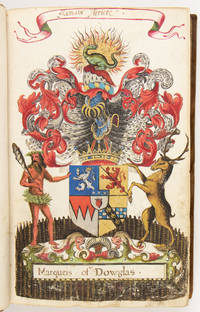
16254028<p>Scotland: 17th c. after 1625</p><p>Folio: 30.6 x 20 cm. 107 lvs. mostly numbered in a contemporary hand: 3 1-8 10-50 1-7 1-34 13 misbound 36-42 1 43-48 48 misbound</p><p>UNPUBLISHED MANUSCRIPT.</p><p>Unpublished manuscript consisting of 107 full-page Scottish coats-of-arms each hand-painted over an underlying generic engraved template. The bare-bones template has minimal detail helm with mantling outline of a blank shield empty compartment with flourishes and serves only as a uniform foundation over which elaborate individualized crests are painted. The first three coats-of-arms are those of royalty and are painted on leaves without the engraved template.</p><p>Bound in 18th century reverse calf in fine condition corners lightly bumped small chip to foot of spine a few signs of wear to lower board. The painted lvs. have been interleaved twice once with lvs. contemporary with the manuscript and again at the time of rebinding in the 18th century. Both sets of blanks present. The volume is in overall very good condition. Two of the paintings have been smudged no. 16 in the first sequence and the unnumbered leaf in the 3rd sequence. One leaf no. 2 in 3rd sequence is torn with loss. There are some early minor paper repairs some a bit crude a few longer clean tears no loss and some smaller tears at the head and foot of scattered leaves. The colors are on the whole very fresh. Individual elements unicorns squirrels mermaids "wild men" and in one instance beavers and Native Americans are painted with nuance and in minute detail.</p><p>Provenance: Bookplate of Thomas Hamilton 1721-1794 7th Earl of Haddington Hadinton. The Hadington arms with the motto "Praesto et presto"I undertake and I persevere are painted on folio 35 first sequence. The title was created in 1627 and bestowed upon the Scottish lawyer and judge Thomas Hamilton First Earl of Melrose d. 1637.</p><p>The volume opens with the arms of Scotland those of the King of Scotland and England and those of the Prince of Wales.</p><p>The manuscript dates to after 1625 the year in which the poet and courtier William Alexander was made 1st Earl of Stirling ca. 1567-1640. Alexander was involved in the Scottish colonization of Nova Scotia and the Stirling arms prominently feature a beaver a Native American and a mermaid. </p><p>Condition notes: old repairs to lvs. 15 18 20 21 51 in first sequence. Leaf 2 3rd sequence torn with loss. Tears to leaf 7 3rd sequence Leaves 16 and 1 smeared. Other minor marginal tears.</p> 17th c., after books
182325421np 1823. 3pp. 1 vols. Folio. bound in later cloth. 3pp. 1 vols. Folio. Sermon of the Month. unknown books