British GuianaABAA

17 résultats
1900WRCAM52852Georgetown British Guiana: James Thomson Argosy Office 1900. Twenty-four photographic reproductions on 16pp. bound in accordion style. Original blue publisher's cloth front board gilt. Light shelf wear. Pressed leaf laid in. Internally clean. Very good. A scarce volume of images of British Guiana from approximately the end of the 19th century produced in London and published by a local newspaper office as a souvenir. The photographic reproductions consist mostly of images of the capital of the colony Georgetown including neighborhood architecture street views government buildings the botanic gardens and the coast. There are also several images of inland gold prospecting sites. Only two copies in OCLC at the University of Texas and the University of the West Indies. James Thomson, Argosy Office hardcover books
193441848Washington D.C.: U.S. Bureau of Mines 1934. First edition. Stapled paper wrappers. A very good copy. 30 pp. Sm. 4to. U.S. Bureau of Mines unknown books
196543412Caracas: Corporación Venezolana de Guayana 1965. First edition. Illustrated paper wrappers. A very good copy lightly soiled institutional library stamps on half-title and fore edge. 7 sections numbered seperately plus documents: 253 pp. Illus. with b/w photos drawings and maps some folding. Sm. 4to. Corporación Venezolana de Guayana unknown books
196643413Caracas: Corporación Venezolana de Guayana 1966. First edition. Illustrated paper wrappers. A very good copy corners bumped. Library stamps on top and bottom edges and on title page. 7 sections numbered seperately plus documents: 401 pp. Illus. with b/w photos drawings and maps some folding. Sm. 4to. Corporación Venezolana de Guayana unknown books
196743414Caracas: Corporación Venezolana de Guayana 1967. First edition. Illustrated paper wrappers. A very good copy corners bumped library stamps on edges and half-title. 7 sections numbered seperately plus documents: 407 pp. Illus. with b/w photos drawings and maps some folding. Sm. 4to. Corporación Venezolana de Guayana unknown books
196843415Caracas: Corporación Venezolana de Guayana 1968. First edition. Illustrated paper wrappers. Very good with light bump in one top corner library stamps on edges front pastedown title and half-title. 7 sections numbered seperately plus documents: 416 pp.; 136 pp. Illus. with b/w photos drawings and maps some folding. Sm. 4to. Corporación Venezolana de Guayana unknown books
196943416Caracas: Corporación Venezolana de Guayana 1969. First edition. Illustrated paper wrappers. Very good with a few spine tears library stamps on edges and half-title. 7 sections numbered seperately: 404 pp. ; 208 pp. annex & docs. Illus. with b/w photos drawings and maps some folding. Sm. 4to. Corporación Venezolana de Guayana unknown books
197143417Caracas: Corporación Venezolana de Guayana 1971. First edition. Illustrated paper wrappers. Very good with a few tears at spine. 7 sections numbered seperately: 282 pp.; 73 pp. Illus. with b/w photos drawings and maps some folding. Sm. 4to. Corporación Venezolana de Guayana unknown books
1828WRCAM30792A Cayenne: L'Imprimerie du Gouvernement 1828. 54pp. Slim quarto. Contemporary plain wrappers. Internally clean and bright. Near fine. A collection of proposed French administrative documents concerning the establishment of a mortgage and loan office in French Guiana. The various articles are geared toward liberal loan regulations to encourage agricultural development including the allowance of slaves as collateral. Since the restoration of the region to French authority in 1817 via the Treaty of Vienna the promotion of an agrarian economy was a primary concern though the subsequent designation of Cayenne as a penal colony significantly reduced the territory's appeal. Like most Cayenne imprints of this era the present document is quite rare. Not on OCLC. L'Imprimerie du Gouvernement unknown books
182418496French Guiana 1824. Together 12 manuscript maps and views plus one engraved map. Provenance: Baron Pierre-Bernard Milius 1773-1829. A fine manuscript cartographic record of Baron Milius's scheme to establish a settlement near the mouth of the river Mana on the far west coast of French Guiana including survey work by Auguste Vaillant.<br/> <br/>"Milius first went to sea in 1786 on his father's merchant ships. He joined the navy in 1793 and in 1800 as 'lieutenant de vaisseau' lieutenant commander was appointed to the Australian Expedition of Nicolas Thomas Baudin. He served as Jacques Hamelin's second-in-command on the Naturaliste and at Timor in 1801 was promoted 'capitaine de frigate' commander" Howgego M44. The importance of the Baudin Expedition cannot be overstated. The 1800-1803 French expedition was the first to survey the western coast and much of the southern coast of Australia. The Expedition harbored at Sydney from the end of April to mid-November 1802. On the return Baudin died of illness and command passed to Milius who successfully brought the expedition back to France. Milius subsequently served as director of the port of Venice returning to France in 1814; "after the restoration of the monarchy in 1815 he was appointed director of the port of Brest. He subsequently served as governor of Reunion 1818-21 and Guiana 1823-25 and in 1827 commanded the Scipion at the Battle of Navarino" Howgego. Milius's service as governor of French Guiana was of particular importance. Originally settled by France in the 17th century the South American tropical region had been seized by Portugal in 1809. After its restoration to France a renewed movement began to colonize the area. Milius himself would be influential in seeking to create a penal colony at Mana and to oversee numerous surveys of the region to determine the feasibility and best places for colonization. The present archive from the collection of Baron Milius dates from his time as the colonial governor of French Guiana and includes several magnificent large-scale maps and views including a masterful manuscript plan of Cayenne as well as important manuscript maps of Mana and the Maroni River by Auguste Nicolas Vaillant 1793-1837. Together this collection represents a stunning visual record of the culmination of Milius's storied career. Original primary source manuscript material from Grand Voyage expeditions is of the utmost rarity and almost exclusively exists in French institutions. Such material that does appear on the market is seldom able to leave France. These newly-discovered drawings from a critical period of French exploration are of great historical value. The collection is comprised of: 1 Auguste Nicolas VAILLANT 1793-1837. Pen ink and wash original manuscript map titled 'Plan de la Partie du Maroni Comprise Entre Son Embouchure Et le Parallêle Situé par 5 degrees 7'.46". de latde. N. Dressé par Augte. Niclo. Vaillant Ensgne. de Vau. pendant Son Voyage dant Ce Fleuve pour le Service de la Commission Explorative de la Guyanne Française'. French Guiana: 1824. Pen and black ink with grey watercolor wash on early 19th-century laid paper 'M' in a shield watermark with 'M' countermark. Sheet size: 39 1/4 x 25 1/2 inches. An attractive record of an important early survey of the border between French Guiana and Surinam. Auguste Vaillant served as 'aide de camp' to Baron Milius and would subsequently command a voyage of circumnavigation aboard the corvette Bonite. He produced this detailed record of soundings and observations about habitation and natural features and hazards on the Rio Maroni: the importance of the work was recognised and he produced a 'memoir' describing the exploration. The Maroni which up until this survey was virtually unknown served then and now as French Guiana's border with Surinam on the west bank. The area surveyed includes a 'Grand village Parêtlaii' on the approximate site of present-day Saint-Laurent du Maroni. As the title makes clear this map was one of the results of an extensive survey carried out for the commission commanded by Baron Milius to explore French Guiana. 2 Auguste Nicolas VAILLANT 1793-1837. An original manuscript map titled 'Croquis du cours de l' Acarouani en de ses Affluence par Augte. Vaillant Ensgne. de Vau. Aide de Camp de Mr. le Bon. Milius'. French Guiana: 17 Juillet 1824. Pen and ink on laid French Grand-Aigle paper watermark: a crowned eagle. Sheet size 25 3/4 x 17 3/4 inches. A detailed chart of the course of the Acarouani River from its headwaters to its confluence with the Mana just upstream from the town from where the town of Mana is now situated. 3 H. PARENT. An original manuscript map titled 'Plan de l'ancienne et nouvelle ville de Cayenne.' French Guiana: 1821. Pencil pen-and-ink and watercolour on laid French Grand-Aigle paper watermark of a crowned eagle watermark with indistinct countermark. Sheet size: 24 1/8 x 35 1/16 inches. A beautifully-finished plan showing the proposed new layout for the capital apparently following the plans drawn up by the surveyor Sirdey the 'arpenteur royal.' This plan marks the moment when Cayenne became a modern colonial capital and is a fascinating and important document in the history of the development of Cayenne. The proposed expansion was only possible because of the amount of land that had been reclaimed by the engineering works which began in 1777. Using convict labour the draining of the marshy land around the old town and the resulting Canal Laussat shown on this plan was also finished in 1821. The Old Town "Ancienne Ville" lies at left; the New Town "Nouveau Ville" at right. It is interesting to note how much of the lay out suggested here is still in existence although very few of the streets have retained their names - the 'Rue de Choiseuil' is now the 'Avenue du général de Gaulle' for instance. 4 Captain BONNE. An original manuscript engineering drawing titled 'Plan d'un Débarcadour en charpente projeté pour le Port de Cayenne. Executé sous l'administration de Mr. le Baron Milius'. French Guiana: March 1823. Pen-and-ink and watercolour wash on laid paper watermark of an 'M' in a shield 'M' countermark. Sheet size: 26 3/8 x 40 inches. Further inscribed "Vue et Approuvé" by Baron Milius with his signature and the date '27 Mars 1823' and also signed by Bonne 'Le capn. au corps Royal du genie militaire.' Four engineering drawings on one large sheet of a proposed boat dock in Cayenne: top elevation side elevation and two details. 5 Captain BONNE. An original manuscript engineering drawing titled 'Plan d'un Débarcadour en charpente projeté pour le Port de Cayenne. French Guiana : circa 1823. Pen ink and watercolour wash on laid French Grand-Aigle paper watermark of a crowned eagle clutching thunderbolts in each foot 'Montgolfier / Annonay' countermark. Sheet size: 26 1/4 x 38 ½ inches. A more finished version of the previous drawing. 6 Captain BONNE. An original manuscript engineering drawing titled 'Projet d'un Pont de débarquement en charpente à construire vis-à -vis le Bureau du Port à Cayenne'. French Guiana 1823. Pen ink and watercolour wash on laid French Grand-Aigle paper watermark of a crowned eagle clutching thunderbolts in each foot 'Montgolfier / Annonay' countermark. Signed by Bonne. Sheet size: 25 x 19 1/8 inches. Detailed engineering plan of a bridge from a disembarking point to the mainland near the 'Bureau du Port' in Cayenne. 7 Captain BONNE. An original manuscript architectural drawing titled 'Plan de l'Hôpital militaire projeté à Cayenne'. French Guiana circa 1823. Pen ink and watercolour wash on laid paper watermark of an 'M' in a shield 'M' countermark. Sheet size: 24 3/4 x 38 5/8 inches. Signed by Bonne 'Le capn. du genie.' A fine architectural drawing of the new wing of the military hospital in Cayenne. 5 parts on one sheet as follows: Floor plan of the new and existing wings; elevation of the new and existing wings which shows the changes to the latter; two cross sections and an elevation of the existing wing before modification. 8 Captain BONNE An original manuscript architectural drawing titled 'Caserne pour 6 compagnies d'infanterie projetée a Cayenne'. French Guiana circa 1823. Pen ink and watercolour wash on 19th century wove paper. Sheet size: 20 3/8 x 26 1/4 inches. Expertly drawn architectural plan for a barracks for "six companies of infantry" at Cayenne. Consists of elevations of three facades a cross section and a plan of the main floor. 9 E. BODIN. An original drawing titled in a cartouche 'Vue du Port de la Nouvelle Angoulême'. French Guiana: July 1824. Pencil and brown wash panorama with black ink ruled border on two joined sheets of laid Dutch Royal paper 'Vande Ley' watermark with countermark of the figure of Fortune on a globe with 'VDL' monogram beneath signed 'E. Bodin del.' in black ink in lower right corner. Sheet size: 16 inches x 46 3/4 inches. A beautifully observed and executed view of this newly-established experimental colonial settlement. The village is shown from the opposite bank of the Mana River from approximately eye-level. Shown within a tropical landscape are eight buildings five of which appear to be private dwellings two public buildings and one at far left a store or warehouse. The next plan by Bodin see below includes the information that he was an 'Ingénieur Géographe de Militaire'. 10 Captaine BRACHE. An original pen ink and watercolour map titled 'Crique Portal depuis son embouchure jusqu'a 40 lieues. Exploration de Mr. le Capne. Brache en Juillet en Aout 1824. d'apres les ordres de Mr. le Baron Milius commandt. et administratr. de la Guyane Fe. pour le Roi.' French Guiana: 1824. Pen and ink map of the course of the river with large watercolour vignette of the rapids of St. Bernard within a black wash border on laid French Grand-Aigle paper watermark of a crowned eagle clutching thunderbolts in each foot with 'Montgolfier / Annonay' countermark. Sheet size 25 1/4 x 35 inches. Shows the course of the 'Crique Portal' a tributary of the Rio Maroni that runs roughly from southwest to northeast specifically designed to show in large inset a series of rapids Saul St. Bernard that obstruct navigation on the river. 11 E. BODIN & Mr. LAINÉ. An original chart titled in a cartouche 'Plan de l'embouchure de la Mana levé et dressé par ordre de Monsieur le Baron Milius commandant a la Guyane pour le Roi par les Officiers de la Goelette de sa Majesté l'Artésienne sous la direction de Mr. Lainé commandant la station de Cayenne conjointement avec Mr. Bodin ingénieur géographe militaire'. French Guiana: July 1824. Pen ink and watercolour chart with soundings marked in black and red title cartouche and explanatory index on a trompe-l'oeil 'sheet' of paper all within black ink ruled border on two joined sheets of laid paper watermark: an 'M' in a shield with an 'M' countermark. Sheet size: 24 5/8 x 46 1/8 inches. A finely-presented manuscript nautical chart of an area of the utmost importance to the settlers on the banks of the Mana in the far north west of French Guiana. Numerous soundings are given and the title cartouche is enriched by the inclusion of two 'cornucopias' overflowing with pineapples mangos paw-paw avocado banana and tropical flowers. A preparatory drawing for the following: 12 E. BODIN & Mr. LAINÉ. An original chart titled in a cartouche 'Plan de l'embouchure de la Mana levé et dressé par ordre de Monsieur le Baron Milius commandant a la Guyane pour le Roi par les Officiers de la Goelette de sa Majesté l'Artésienne sous la direction de Mr. Lainé Commandant la Station de Cayenne conjointement avec Mr. Bodin Ingénieur Géographe de Militaire'. French Guiana: July 1824. Pen ink and watercolour chart with soundings marked in black and red title cartouche and explanatory index on a trompe-l'oeil 'sheet' of paper all within black ink ruled border on two joined sheets of laid French Grand-Aigle paper signed 'E. Bodin Direxit.' in red ink in lower right corner crowned eagle with indistinct countermark. Sheet size: 24 1/8 x 44 3/4 inches. A more highly finished variant to the above with additions and corrections and signed by Bodin. 13 GRESSIER. Plan de l'Embouchure de la Rivière de Cayenne et des Mouillages Extérieurs Levé en Mars 1820 dans la Campagne de la Corvette la Bayadère et du Brick Le Favori par M. M. Gressier Ingénieur Hydrographe de la Marine . Sous les Ordres et la Direction de M. le Baron Roussin . Chef de l'Expédition. Paris: Dépòt-général de la Marine 1822. Black and white copper-engraving. Sheet size: 27 1/2 x 40 1/8 inches. A fine engraved marine chart almost contemporary with the manuscript plans and drawings above. It shows Cayenne and its vicinity in detail and includes an inset of the Iles du Salut including the infamous Devil's Island.<br/> <br/>Howgego M44 & V1. unknown books
1799311123London: printed for J. Wright 1799. First English edition. 4 215 pp. 8vo. Contemporary sprinkled calf morocco spine label lettered in gilt. Some rubbing to binding small split to front joint minor marginal worming at beginning. First English edition. 4 215 pp. 8vo. Narrative of the exile of several French revolutionaries to the penal colony of Cayenne in Guiana giving account of travel in the colony and of the voyage residence and escape. Sabin 67630 printed for J. Wright unknown books
1885WRCAM31214Georgetown Dem.: R.P. Kaps 1885. Small postcard 5 1/2 x 3 1/2 inches. Standard postcard text on verso. Minor chip in lower right corner. Very good. A postcard from Demerara featuring a photograph of St. Georges Cathedral taken by R.P. Kaps. R.P. Kaps unknown books
19491522British Guiana 1949. Very good. Two volumes. 6633 photographs on 3311pp. Images vary in size most 4.5 x 4.5 or 3.5 x 2.5 inches with some larger. Oblong octavos. Original black paper albums string-tied. Cover of first volume detached wear around edges of covers on each volume. Internally clean and fresh. Some images with light silver mirroring. Captioned throughout. Two photograph albums of the Tikwah gold mine in British Guiana likely compiled by an operative of the company. A Who's Who of British Guiana for 1945-1948 lists Samuel Hirsh Holzman as the mine owner and managing director as well as the vice president of the Mining Association of British Guiana. Gold was discovered in Guiana in the 1880s in the area around the Essequibo River. Crude mining efforts through the next few decades resulted in minimal extraction though there was a renewed effort with technological advancements in mining in the 1940s as shown herein. The present albums document the region as well as the mining camp and its operations much of it with a keen sense of detail. In addition to captions the author has annotated many of the photos in pencil to point out relevant features. For example a photograph captioned "New Winze L. & General View of Mine Looking N.W." has pencil annotations identifying individual buildings such as the Clerk's Quarters and the Tikwah Shaft Building. An image of the foreman's shack and laborers' quarters notes the construction and materials used to build them; roads and rivers used by the company are pictured with complaints about the rough condition as are aerial views of the camp and surrounding area. There are images of the shafts and miners at work; interior shots of the mills and other buildings; and the latter portion of the first volume contains numerous group portraits of the workers and office staff each person identified by name and position. This includes the "Tikwah Ladies" mostly the wives of foremen which shows eight Black women standing together in the mining camp one holding an infant and another holding the hands of a toddler. In addition to images of the camp's operations there are many photographs documenting the difficulties involved with mining in the jungle. A series of images from 1948 shows workmen transporting equipment on the Puruni River. Captions read "Reloading boats to proceed up Puruni ballyhoo in front towed by 'Caroline' to be used at Thomas Island Falls for blasting"; "Pulling 'Caroline' over rapids at mouth"; "Pulling 'Caroline' through part of big falls." All of these images show the difficulty of transporting equipment and supplies in the region with laborers in shorts and loincloths pulling the boat with a rope over difficult terrain. Another series shows the boat caught up on rocks in the river at Kaburi Falls and the workmen endeavoring to dislodge it without capsizing. An altogether fascinating look at life in a mining camp in the jungles of Guiana full of rich detail about those working in the camp and their living environs. unknown books
216661Amsterdam: Blaeu n.d. With contemporary coloring. Large Cartouche hand-colored upper rigt "Guiana sive Amazonum Regio." Signed "Guiljelmus Blaew" lower right. 1 vols. 15-3/4 x 20 inches. Mounted and framed. With contemporary coloring. Large Cartouche hand-colored upper rigt "Guiana sive Amazonum Regio." Signed "Guiljelmus Blaew" lower right. 1 vols. 15-3/4 x 20 inches. Blaeu unknown books
1971212003Georgetown-: the Institute 1971. 30p. mimeographed sheets stapled at left minor staple scrapes at right edge of front cover otherwise very good. 8.5x11 inches. the Institute unknown books
18372252821837. Watercolor on paper. 19 x 26 cm. 7-1/2 x 10-1/4 inches. Matted. Watercolor on paper. 19 x 26 cm. 7-1/2 x 10-1/4 inches. Adriaan David van der Gon Netscher was a member of the Netscher family a Dutch military family that traces its heritage back to the 1600s. <br/><br/>Adriaan David was a naval officer honorably discharged in 1848 and a member of the Court of Police in British Guyana where he painted this striking little watercolor of the Public Building. unknown books
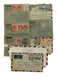
1951734561951. Paperback. Good. All appear to be written in 1951 and all were sent to Rev. Campbell MacRae Lewistall who is identified on a slip laid in one of the envelopes as Founder-teacher Blyden-Lewistall Private School at 314 West 133rd Street in New York City. Some letters are worn; all appear to be complete. Most envelopes present some with stamps. Three of the letters were from Philip Nathaniel King headmaster or head teacher of this Methodist-supported elementary school; one is from his wife; two are from his son; and two are from Mr. King's niece who was also a teacher at the school. All of the letters seem designed to establish contact with Rev. Lewistall who is addressed as Uncle. Some including the letters from King's son thank the New York Uncle for gifts such as an air rifle. It is clear from the letters that conditions at the school were far from ideal and that the Kings were hoping that their uncle in America would provide some financial support. <br/><br/> paperback books