FRENCH GUIANA Pierre Bernard Baron MILIUS 1773 1829 Auguste Nicolas VAILLANT 1793 1837 & E. BODINABAA

929 résultats
182418496French Guiana 1824. Together 12 manuscript maps and views plus one engraved map. Provenance: Baron Pierre-Bernard Milius 1773-1829. A fine manuscript cartographic record of Baron Milius's scheme to establish a settlement near the mouth of the river Mana on the far west coast of French Guiana including survey work by Auguste Vaillant.<br/> <br/>"Milius first went to sea in 1786 on his father's merchant ships. He joined the navy in 1793 and in 1800 as 'lieutenant de vaisseau' lieutenant commander was appointed to the Australian Expedition of Nicolas Thomas Baudin. He served as Jacques Hamelin's second-in-command on the Naturaliste and at Timor in 1801 was promoted 'capitaine de frigate' commander" Howgego M44. The importance of the Baudin Expedition cannot be overstated. The 1800-1803 French expedition was the first to survey the western coast and much of the southern coast of Australia. The Expedition harbored at Sydney from the end of April to mid-November 1802. On the return Baudin died of illness and command passed to Milius who successfully brought the expedition back to France. Milius subsequently served as director of the port of Venice returning to France in 1814; "after the restoration of the monarchy in 1815 he was appointed director of the port of Brest. He subsequently served as governor of Reunion 1818-21 and Guiana 1823-25 and in 1827 commanded the Scipion at the Battle of Navarino" Howgego. Milius's service as governor of French Guiana was of particular importance. Originally settled by France in the 17th century the South American tropical region had been seized by Portugal in 1809. After its restoration to France a renewed movement began to colonize the area. Milius himself would be influential in seeking to create a penal colony at Mana and to oversee numerous surveys of the region to determine the feasibility and best places for colonization. The present archive from the collection of Baron Milius dates from his time as the colonial governor of French Guiana and includes several magnificent large-scale maps and views including a masterful manuscript plan of Cayenne as well as important manuscript maps of Mana and the Maroni River by Auguste Nicolas Vaillant 1793-1837. Together this collection represents a stunning visual record of the culmination of Milius's storied career. Original primary source manuscript material from Grand Voyage expeditions is of the utmost rarity and almost exclusively exists in French institutions. Such material that does appear on the market is seldom able to leave France. These newly-discovered drawings from a critical period of French exploration are of great historical value. The collection is comprised of: 1 Auguste Nicolas VAILLANT 1793-1837. Pen ink and wash original manuscript map titled 'Plan de la Partie du Maroni Comprise Entre Son Embouchure Et le Parallêle Situé par 5 degrees 7'.46". de latde. N. Dressé par Augte. Niclo. Vaillant Ensgne. de Vau. pendant Son Voyage dant Ce Fleuve pour le Service de la Commission Explorative de la Guyanne Française'. French Guiana: 1824. Pen and black ink with grey watercolor wash on early 19th-century laid paper 'M' in a shield watermark with 'M' countermark. Sheet size: 39 1/4 x 25 1/2 inches. An attractive record of an important early survey of the border between French Guiana and Surinam. Auguste Vaillant served as 'aide de camp' to Baron Milius and would subsequently command a voyage of circumnavigation aboard the corvette Bonite. He produced this detailed record of soundings and observations about habitation and natural features and hazards on the Rio Maroni: the importance of the work was recognised and he produced a 'memoir' describing the exploration. The Maroni which up until this survey was virtually unknown served then and now as French Guiana's border with Surinam on the west bank. The area surveyed includes a 'Grand village Parêtlaii' on the approximate site of present-day Saint-Laurent du Maroni. As the title makes clear this map was one of the results of an extensive survey carried out for the commission commanded by Baron Milius to explore French Guiana. 2 Auguste Nicolas VAILLANT 1793-1837. An original manuscript map titled 'Croquis du cours de l' Acarouani en de ses Affluence par Augte. Vaillant Ensgne. de Vau. Aide de Camp de Mr. le Bon. Milius'. French Guiana: 17 Juillet 1824. Pen and ink on laid French Grand-Aigle paper watermark: a crowned eagle. Sheet size 25 3/4 x 17 3/4 inches. A detailed chart of the course of the Acarouani River from its headwaters to its confluence with the Mana just upstream from the town from where the town of Mana is now situated. 3 H. PARENT. An original manuscript map titled 'Plan de l'ancienne et nouvelle ville de Cayenne.' French Guiana: 1821. Pencil pen-and-ink and watercolour on laid French Grand-Aigle paper watermark of a crowned eagle watermark with indistinct countermark. Sheet size: 24 1/8 x 35 1/16 inches. A beautifully-finished plan showing the proposed new layout for the capital apparently following the plans drawn up by the surveyor Sirdey the 'arpenteur royal.' This plan marks the moment when Cayenne became a modern colonial capital and is a fascinating and important document in the history of the development of Cayenne. The proposed expansion was only possible because of the amount of land that had been reclaimed by the engineering works which began in 1777. Using convict labour the draining of the marshy land around the old town and the resulting Canal Laussat shown on this plan was also finished in 1821. The Old Town "Ancienne Ville" lies at left; the New Town "Nouveau Ville" at right. It is interesting to note how much of the lay out suggested here is still in existence although very few of the streets have retained their names - the 'Rue de Choiseuil' is now the 'Avenue du général de Gaulle' for instance. 4 Captain BONNE. An original manuscript engineering drawing titled 'Plan d'un Débarcadour en charpente projeté pour le Port de Cayenne. Executé sous l'administration de Mr. le Baron Milius'. French Guiana: March 1823. Pen-and-ink and watercolour wash on laid paper watermark of an 'M' in a shield 'M' countermark. Sheet size: 26 3/8 x 40 inches. Further inscribed "Vue et Approuvé" by Baron Milius with his signature and the date '27 Mars 1823' and also signed by Bonne 'Le capn. au corps Royal du genie militaire.' Four engineering drawings on one large sheet of a proposed boat dock in Cayenne: top elevation side elevation and two details. 5 Captain BONNE. An original manuscript engineering drawing titled 'Plan d'un Débarcadour en charpente projeté pour le Port de Cayenne. French Guiana : circa 1823. Pen ink and watercolour wash on laid French Grand-Aigle paper watermark of a crowned eagle clutching thunderbolts in each foot 'Montgolfier / Annonay' countermark. Sheet size: 26 1/4 x 38 ½ inches. A more finished version of the previous drawing. 6 Captain BONNE. An original manuscript engineering drawing titled 'Projet d'un Pont de débarquement en charpente à construire vis-à -vis le Bureau du Port à Cayenne'. French Guiana 1823. Pen ink and watercolour wash on laid French Grand-Aigle paper watermark of a crowned eagle clutching thunderbolts in each foot 'Montgolfier / Annonay' countermark. Signed by Bonne. Sheet size: 25 x 19 1/8 inches. Detailed engineering plan of a bridge from a disembarking point to the mainland near the 'Bureau du Port' in Cayenne. 7 Captain BONNE. An original manuscript architectural drawing titled 'Plan de l'Hôpital militaire projeté à Cayenne'. French Guiana circa 1823. Pen ink and watercolour wash on laid paper watermark of an 'M' in a shield 'M' countermark. Sheet size: 24 3/4 x 38 5/8 inches. Signed by Bonne 'Le capn. du genie.' A fine architectural drawing of the new wing of the military hospital in Cayenne. 5 parts on one sheet as follows: Floor plan of the new and existing wings; elevation of the new and existing wings which shows the changes to the latter; two cross sections and an elevation of the existing wing before modification. 8 Captain BONNE An original manuscript architectural drawing titled 'Caserne pour 6 compagnies d'infanterie projetée a Cayenne'. French Guiana circa 1823. Pen ink and watercolour wash on 19th century wove paper. Sheet size: 20 3/8 x 26 1/4 inches. Expertly drawn architectural plan for a barracks for "six companies of infantry" at Cayenne. Consists of elevations of three facades a cross section and a plan of the main floor. 9 E. BODIN. An original drawing titled in a cartouche 'Vue du Port de la Nouvelle Angoulême'. French Guiana: July 1824. Pencil and brown wash panorama with black ink ruled border on two joined sheets of laid Dutch Royal paper 'Vande Ley' watermark with countermark of the figure of Fortune on a globe with 'VDL' monogram beneath signed 'E. Bodin del.' in black ink in lower right corner. Sheet size: 16 inches x 46 3/4 inches. A beautifully observed and executed view of this newly-established experimental colonial settlement. The village is shown from the opposite bank of the Mana River from approximately eye-level. Shown within a tropical landscape are eight buildings five of which appear to be private dwellings two public buildings and one at far left a store or warehouse. The next plan by Bodin see below includes the information that he was an 'Ingénieur Géographe de Militaire'. 10 Captaine BRACHE. An original pen ink and watercolour map titled 'Crique Portal depuis son embouchure jusqu'a 40 lieues. Exploration de Mr. le Capne. Brache en Juillet en Aout 1824. d'apres les ordres de Mr. le Baron Milius commandt. et administratr. de la Guyane Fe. pour le Roi.' French Guiana: 1824. Pen and ink map of the course of the river with large watercolour vignette of the rapids of St. Bernard within a black wash border on laid French Grand-Aigle paper watermark of a crowned eagle clutching thunderbolts in each foot with 'Montgolfier / Annonay' countermark. Sheet size 25 1/4 x 35 inches. Shows the course of the 'Crique Portal' a tributary of the Rio Maroni that runs roughly from southwest to northeast specifically designed to show in large inset a series of rapids Saul St. Bernard that obstruct navigation on the river. 11 E. BODIN & Mr. LAINÉ. An original chart titled in a cartouche 'Plan de l'embouchure de la Mana levé et dressé par ordre de Monsieur le Baron Milius commandant a la Guyane pour le Roi par les Officiers de la Goelette de sa Majesté l'Artésienne sous la direction de Mr. Lainé commandant la station de Cayenne conjointement avec Mr. Bodin ingénieur géographe militaire'. French Guiana: July 1824. Pen ink and watercolour chart with soundings marked in black and red title cartouche and explanatory index on a trompe-l'oeil 'sheet' of paper all within black ink ruled border on two joined sheets of laid paper watermark: an 'M' in a shield with an 'M' countermark. Sheet size: 24 5/8 x 46 1/8 inches. A finely-presented manuscript nautical chart of an area of the utmost importance to the settlers on the banks of the Mana in the far north west of French Guiana. Numerous soundings are given and the title cartouche is enriched by the inclusion of two 'cornucopias' overflowing with pineapples mangos paw-paw avocado banana and tropical flowers. A preparatory drawing for the following: 12 E. BODIN & Mr. LAINÉ. An original chart titled in a cartouche 'Plan de l'embouchure de la Mana levé et dressé par ordre de Monsieur le Baron Milius commandant a la Guyane pour le Roi par les Officiers de la Goelette de sa Majesté l'Artésienne sous la direction de Mr. Lainé Commandant la Station de Cayenne conjointement avec Mr. Bodin Ingénieur Géographe de Militaire'. French Guiana: July 1824. Pen ink and watercolour chart with soundings marked in black and red title cartouche and explanatory index on a trompe-l'oeil 'sheet' of paper all within black ink ruled border on two joined sheets of laid French Grand-Aigle paper signed 'E. Bodin Direxit.' in red ink in lower right corner crowned eagle with indistinct countermark. Sheet size: 24 1/8 x 44 3/4 inches. A more highly finished variant to the above with additions and corrections and signed by Bodin. 13 GRESSIER. Plan de l'Embouchure de la Rivière de Cayenne et des Mouillages Extérieurs Levé en Mars 1820 dans la Campagne de la Corvette la Bayadère et du Brick Le Favori par M. M. Gressier Ingénieur Hydrographe de la Marine . Sous les Ordres et la Direction de M. le Baron Roussin . Chef de l'Expédition. Paris: Dépòt-général de la Marine 1822. Black and white copper-engraving. Sheet size: 27 1/2 x 40 1/8 inches. A fine engraved marine chart almost contemporary with the manuscript plans and drawings above. It shows Cayenne and its vicinity in detail and includes an inset of the Iles du Salut including the infamous Devil's Island.<br/> <br/>Howgego M44 & V1. unknown books
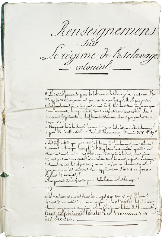
LBW-8723Cayenne, 4 février 1837. Manuscrit autographe signé. In-folio (36,5 x 24 cm) de (3) ff. dont le titre, 15 et (12) ff.; broché, rubans de soie verte.
005460Paris, Louis Billaine, 1674. Cinq parties reliées en un volume in-quarto (180 X 250 mm) basane fauve marbrée, dos brun à nerfs orné de fers dorés, titre doré, tranches mouchetées en rouge (Reliure de l’époque) ; (8) ff. de titre, avis au lecteur, extrait du privilège, 262 pages, 14 planches h.-t. (dont 7 dépliantes) - 23 pages - 49 pages, 3 planches h.-t. - 83 pages [et non 81 pages, il y a en effet deux pages 54/55], 1 planche dépliante h.-t. - 35 pages, 1 planche dépliante h.-t. Discrètes et habiles restaurations à la reliure, épidermures sur les plats, infime travail de ver en fond de cahier sans atteinte au texte du premier tiers de l'ouvrage. SANS le faux titre "Colonies Anglaises" ni la CARTE de la "Description Topographique et mesure de l'Isle des Barbades aux Indes Occidentales" qui manque souvent.
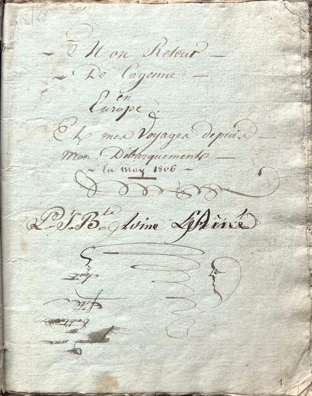
18061866, , 1806-1831. Manuscrit in-8 carré de (49) pp., texte copié à l'encre brune, sur papier bleuté et blanc, écriture cursive bien lisible jusqu'en janvier 1818 mais plus difficile à déchiffrer les dernières pp. 47-49, titre et signature inscrits à l'encre sur la première page, deux cahiers cousus, sous couverture d'attente muette, documents conservés dans un emboîtage demi-chagrin bleu moderne. Couverture salie, quelques mouillures.
1828WRCAM30792A Cayenne: L'Imprimerie du Gouvernement 1828. 54pp. Slim quarto. Contemporary plain wrappers. Internally clean and bright. Near fine. A collection of proposed French administrative documents concerning the establishment of a mortgage and loan office in French Guiana. The various articles are geared toward liberal loan regulations to encourage agricultural development including the allowance of slaves as collateral. Since the restoration of the region to French authority in 1817 via the Treaty of Vienna the promotion of an agrarian economy was a primary concern though the subsequent designation of Cayenne as a penal colony significantly reduced the territory's appeal. Like most Cayenne imprints of this era the present document is quite rare. Not on OCLC. L'Imprimerie du Gouvernement unknown books
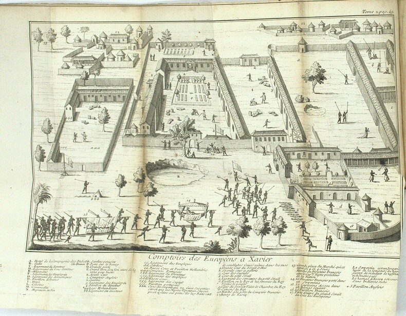
In-8 (mm. 248x185), elegante legatura in p. pelle bazana coeva, cornice dorata ai piatti, dorso a cordoni con decorazioni floreali e tit. oro su tassello, tagli rossi, pp. (2),XIV,(2),294,(2), inclusa la bella antiporta-frontespizio entro pregevole cornice decorata, incisa da Croisey, e con grande testata alle armi alla Prefazione (pure inc. in rame). Il volume è molto ben illustrato f.t. da 10 tavole che raffigurano indigeni, loro usi e costumi, caccia e pesca, animali, piante e frutta, e da 19 (su 20) carte, tutte inc. in rame (7 più volte ripieg.), di cui 1 con la pianta della città di Paramaribo. Fra le carte geografiche: quella generale della Guiana, del Surinam, della Guiana francese, dell’isola e della città di Cayenne e della Guiana portoghese; le restanti illustrano il percorso dei vari fiumi, a partire dal più importante, l’Orenoco. Manca la carta con la ”grande embouchure de l’Orenoque et partie de son cours”. L’opera contiene “les possessions et les établissemens des François, des Espagnols, des Portugais, des Hollandois dans ces vastes pays. Le climat, les productions de la terre et les animaux. Leurs habitans, leurs moeurs, leurs coutumes, et le commerce qu’on y peut faire. Avec des remarques pour la navigation et des cartes, plans et figures”. "Prima edizione". Jacques Nicolas Bellin, ingegnere idrografo francese (1703-1772) fu il primo “Ingenieur de la Marine et du Depot des Plans de la Marine” (l’ufficio idrografico francese) e venne nominato idrografo ufficiale (capo cartografo) del Re di Francia. Durante tale regno il ‘Depot’ produsse un notevole numero di carte geografiche fra cui un atlante delle coste francesi col titolo di "Nettuno francese"; l’"Idrografia francese" contenente le carte delle coste di tutto il mondo nel 1756, e il "Piccolo atlante marittimo", in 5 volumi, nel 1764. Così Diz. Larousse,II, p.429. Cfr. anche Brunet, I,756 - Tooley’s Dictionary of Mapmakers, p. 49. Con numerosi piccoli fori di tarlo sapientemente restaurati, altrimenti esemplare ben conservato.
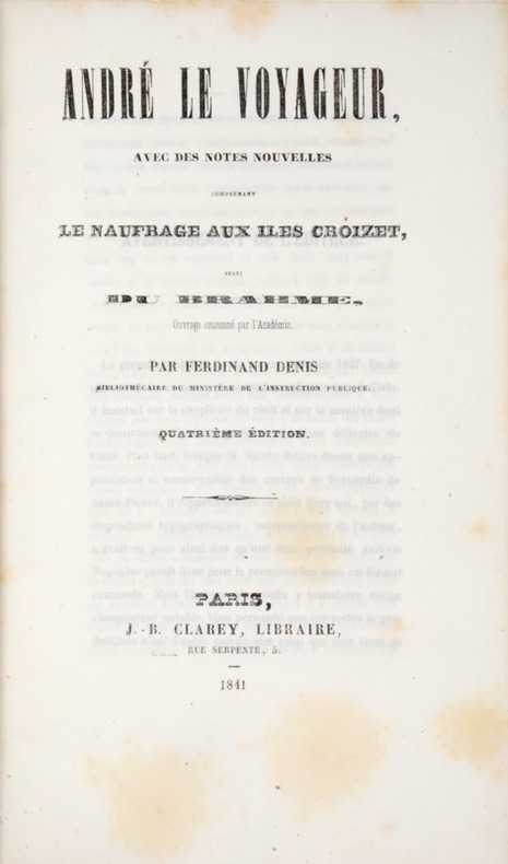
184139808Paris, Clarey, 1841. In-8 de (4)-III-259 pp. maroquin vert, dos orné à nerfs, triple filet doré d’encadrement sur les plats, dentelle intérieure dorée, tranches dorées sur marbrure, non rogné (Brany).
179712434Paris, Du Pont, 1797. In-8 de XXIV-237 pp., 1 planche dépliante, veau raciné, dos lisse orné, pièce de titre en mariquin rouge, tranches mouchetées (reliure de l'époque).
19491522British Guiana 1949. Very good. Two volumes. 6633 photographs on 3311pp. Images vary in size most 4.5 x 4.5 or 3.5 x 2.5 inches with some larger. Oblong octavos. Original black paper albums string-tied. Cover of first volume detached wear around edges of covers on each volume. Internally clean and fresh. Some images with light silver mirroring. Captioned throughout. Two photograph albums of the Tikwah gold mine in British Guiana likely compiled by an operative of the company. A Who's Who of British Guiana for 1945-1948 lists Samuel Hirsh Holzman as the mine owner and managing director as well as the vice president of the Mining Association of British Guiana. Gold was discovered in Guiana in the 1880s in the area around the Essequibo River. Crude mining efforts through the next few decades resulted in minimal extraction though there was a renewed effort with technological advancements in mining in the 1940s as shown herein. The present albums document the region as well as the mining camp and its operations much of it with a keen sense of detail. In addition to captions the author has annotated many of the photos in pencil to point out relevant features. For example a photograph captioned "New Winze L. & General View of Mine Looking N.W." has pencil annotations identifying individual buildings such as the Clerk's Quarters and the Tikwah Shaft Building. An image of the foreman's shack and laborers' quarters notes the construction and materials used to build them; roads and rivers used by the company are pictured with complaints about the rough condition as are aerial views of the camp and surrounding area. There are images of the shafts and miners at work; interior shots of the mills and other buildings; and the latter portion of the first volume contains numerous group portraits of the workers and office staff each person identified by name and position. This includes the "Tikwah Ladies" mostly the wives of foremen which shows eight Black women standing together in the mining camp one holding an infant and another holding the hands of a toddler. In addition to images of the camp's operations there are many photographs documenting the difficulties involved with mining in the jungle. A series of images from 1948 shows workmen transporting equipment on the Puruni River. Captions read "Reloading boats to proceed up Puruni ballyhoo in front towed by 'Caroline' to be used at Thomas Island Falls for blasting"; "Pulling 'Caroline' over rapids at mouth"; "Pulling 'Caroline' through part of big falls." All of these images show the difficulty of transporting equipment and supplies in the region with laborers in shorts and loincloths pulling the boat with a rope over difficult terrain. Another series shows the boat caught up on rocks in the river at Kaburi Falls and the workmen endeavoring to dislodge it without capsizing. An altogether fascinating look at life in a mining camp in the jungles of Guiana full of rich detail about those working in the camp and their living environs. unknown books
1730PHO-1650Paris, Saugrain, 1730.4 vol. in-12 de I. xxiv-[2]-381 pp., 15 pl. ; II. [4]-364 pp. 12 pl. ; III. [4]-350 pp., 4 pl.; IV. [4] pp., pp. 345-682, [36] pp., 1 pl., les tomes I à III reliés en basane brune, dos à nerfs ornés, p. de titre en mar. rouge, p. de titre en veau blond ; le tome IV reliés en veau brun, dos à nerfs ornés, p. de titre et de tomaison en mar. grenat (reliures de l'époque).
18372252821837. Watercolor on paper. 19 x 26 cm. 7-1/2 x 10-1/4 inches. Matted. Watercolor on paper. 19 x 26 cm. 7-1/2 x 10-1/4 inches. Adriaan David van der Gon Netscher was a member of the Netscher family a Dutch military family that traces its heritage back to the 1600s. <br /> <br /> Adriaan David was a naval officer honorably discharged in 1848 and a member of the Court of Police in British Guyana where he painted this striking little watercolor of the Public Building. unknown
18372252821837. Watercolor on paper. 19 x 26 cm. 7-1/2 x 10-1/4 inches. Matted. Watercolor on paper. 19 x 26 cm. 7-1/2 x 10-1/4 inches. Adriaan David van der Gon Netscher was a member of the Netscher family a Dutch military family that traces its heritage back to the 1600s. <br/><br/>Adriaan David was a naval officer honorably discharged in 1848 and a member of the Court of Police in British Guyana where he painted this striking little watercolor of the Public Building. unknown books
188643203Paris, Librairie polytechnique Baudry et Cie, 1886. In-8 de (4)-147 pp., figures dans le texte.LAUR (P.). Du gisement et de l'exploitation de l'or en Californie. Paris, Dunod, 1863. In-8 de (4)-89 pp., 6 planches repliées hors texte.Les deux pièces reliées en 1 vol. in-8, demi-chagrin vert, dos orné à nerfs (reliure de l'époque).
234965Paris, 7 août 1817 bifeuillet in-folio, écrit sur la première page, en feuille.
346<p>FRENCH GUIANA. BARRÈRE Pierre Essai sur l'histoire naturelle de la France équinoxiale ou Dénombrement des Plantes des Animaux & des Minéraux qui se trouvent dans l'Isle de Cayenne les Isles de Remire sur les Côtes de la Mer & dans le Continent de la Guyane Paris Piget 1741.<br />8° XXIV 216 pages 4 leaves ; contemporary calf.</p><p><br />The first monograph on French Guiana's natural history<br />First edition ; one of the scarce large paper copies mentioned by Sabin. Pierre Barrère 1690-1755 was a French physician and botanist from Perpignan. His thesis on the medical uses of botany attracted the attention of Antoine de Jussieu who put forward his name to the French regent Philippe d'Orléans. He was sent to French Guiana "France équinoxiale " as the King's physician and botanist in Cayenne from 1722 to 1725 to look for medecinal plants. During his stay in the colony he collected plants roots fruits and seeds as well as rocks and minerals which were incorporated into Jussieu's herbarium. After an epidemic of yellow fever he returned to France where in 1741 he published this work on the natural history of Cayenne and Remire in which he compiled a very complete alphabetical list of the plants of this part of the world - he referred to the nomenclature of Tournefort and Plumier - as well as the fauna and minerals. This book was followed by another entitled Nouvelle Relation de la France équinoxale in 1743.</p><p>Provenance: Jean-Baptiste Benoît Eyriès 1767-1846 geographer printer/editor and slave trader printed bookplate; Rémi Valdemar Chardey 1813-1900 collector from Le Havre who purchased part of the former's library at its posthumous sale.</p><p>Pritzel 425; Sabin 3603; Leclerc 1511: "This work is more difficult to find than the Relation de la France Equinoxiale by the same author."</p>
1806PHO-2337A Paris, Colnet, 1806. 3 vol. in-8, 558pp., 469pp., 362pp., demi-basane fauve à coins parchemin ivoire, dos lisse, pièce de titre brune, dos frottés, coins et coupes usés, pièces de tomaisons incomplètes, défauts dont rousseurs, mouillure claire au début de t.3 et fin t.2, petites taches d’encre et fentes sans manque sur la carte). Ouvrage illustré d'une carte dépliante et de 3 plans illustrant la ville de Caracas, le port de la Goayre, la rade et la ville de Porto Cabello.
16881Paris, Alphonse Lemerre, 1927. In-12, 237 pp., broché, couverture originale imprimée (petits frottements, quelques petites taches).
216661Amsterdam: Blaeu n.d. With contemporary coloring. Large Cartouche hand-colored upper rigt "Guiana sive Amazonum Regio." Signed "Guiljelmus Blaew" lower right. 1 vols. 15-3/4 x 20 inches. Mounted and framed. With contemporary coloring. Large Cartouche hand-colored upper rigt "Guiana sive Amazonum Regio." Signed "Guiljelmus Blaew" lower right. 1 vols. 15-3/4 x 20 inches. Blaeu unknown
216661Amsterdam: Blaeu n.d. With contemporary coloring. Large Cartouche hand-colored upper rigt "Guiana sive Amazonum Regio." Signed "Guiljelmus Blaew" lower right. 1 vols. 15-3/4 x 20 inches. Mounted and framed. With contemporary coloring. Large Cartouche hand-colored upper rigt "Guiana sive Amazonum Regio." Signed "Guiljelmus Blaew" lower right. 1 vols. 15-3/4 x 20 inches. Blaeu unknown books
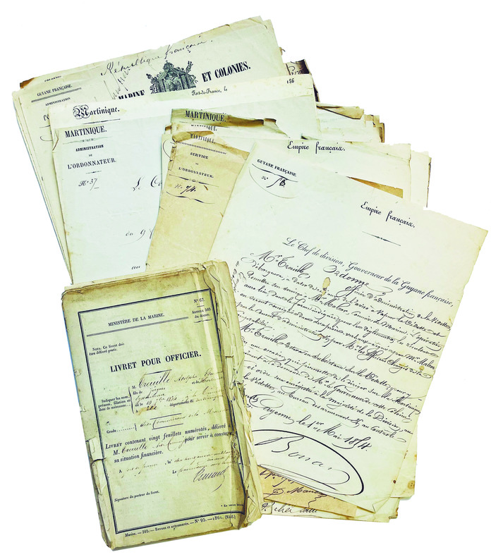
1853LBW-7989Fort-de-France, Cayenne, Saint-Louis (pour la plupart), 1853-1874. 37 pp. petit in-folio (env. 30 x 22 cm) ; en feuilles. On joint un livret de solde au nom d’Adolphe Treuille, dérelié, bords déchirés et froissés.
1730PHO-1965Paris, Saugrain, 1730.4 vol. in-12 de I. xxiv-[2]-381 pp., 14 pl. ; II. [4]-364 pp. 11 pl. ; III. [4]-350 pp., 4 pl.; IV. [4] pp., pp. 345-682, [36] pp., 1 pl., veau brun époque, dos usés avec manque, 1 carte volante, 1 carte avec déchirure sans manque. De la bibliothèque de Sir William Geary, 2nd baronnet (1756 –1825) homme politique conservateur anglais avec son ex-libris
1376635Paris: Lahure, 1899 in plano (75 x 57 cm), 91 cartes en noir et blanc et en couleurs (plusieurs à double page). Facsimilé des cartes manuscrites ou éditées entre 1515 et 1705. Demi reliure basane rouge, dos à 7 nerfs, fleurons et filets dorés, lég. frottements, autrement très bon état. (Atlas pesant 15 kg, prévoir des frais de port en conséquence).
Abundant black and white illustrations and reproductions of photos. Features: Beyond the Law - Part II of the first true account of the exploits of the world's most outlaws, The Dalton Gang, written by their only survivor, Emmett Dalton; A Concert Party In the Desert - The "Roosters" Concert Party entertain troops in the Sinai Desert (with photos); Exploring the Ice-Wilds of Eastern Karakoram - Part II of Fanny and William Workman's exploration of the Himalayas (with photos); The Cruise of the Cowboys - several men are Shanghaied at San Francisco but manage to escape on a small boat and get their revenge; The Hundredth Chance - illicit whisky distillers create major problems for Custom-house officer Alan Temple; ; Our Adventures in Sicily - travel adventures of Penelope and her husband; Boss of the Lava Walls - fight for dominance between two wallaroos; Children's Fight With a Panther - Anthony Farrer and Doreen Ashburnham, both of Cowichan Lake, British Columbia, fight off a panther and are awarded the Albert Medal by the King; A Woman's Journey Across Africa - Part III - Eva Jordan continues her 4,000 mile trek through the great Equatorial Forest of Central Africa; The Mad Druid - a young French girl, Aline Etieve, falls into the hands of a madman thinking himself to be the last Druid, and plotting to offer her as a human sacrifice; The Romance of Platinum-Mining - Ashmore Russan provides a striking account of this much-sought metal - article with photos of related activity on the Rio Opogodo, including a large dredge under construction; My Wanderings Through Texas - a breezy and fascinating pen-picture of a tramp through Texas; How We Outwitted the Bandits - two hostages eventually escape from bandits in Patagonia, South America; Wonders of British Guinana - E.C. Stembridge is enthusiastic over the future of this, the only possession of Great Britain on the mainland of South America; and more. pp. 8 [ads], [3], 90-176, 9-16 [ads]. Clean and unmarked with moderate wear. A quality vintage copy of this wonderful issue. Book
ORD-19735et les Nègres. Traduit de l'anglais par P. F. Henry. ATLAS seul.- Paris. Buisson. An VII de la République (1799). 1 volume in-4 (214 x 282 mm) dos à 5 nerfs et coins veau fauve, doubles filets dorés, pièces de titres maroquin rouge et noir, complet des 44 planches, certaines rempliées. Signature manuscrite sur la page de titre Stanislas Grabowski 1799. Quelques rousseurs pâles essentiellement marginales, reliure un peu frottée, petits défauts d'usage, planches en bon état.
168538552Amsterdam Joannes van Keulen (1685). Altkolor. Orig.-Kupferstichkarte im Format ca. 51 x 58 cm. = Orig. hand coloured copper engraved antique map of French Guiana. == Orig. carte géogr. gravées sur cuivre de la Guyane française, coloriée à la main à l'époque. Sauber u. gut erhalten.