20 957 résultats
191862957New York Chicago & San Francisco: Automobile Blue Book Publishing Co. Inc. 1918. Thick tall 8vo. 1324 pp i.e. 1342. including the colour-tinted inserts including 1 large folding w/ map. Large folding double-sized frontisp. maps many maps strip maps illustrated ads text illustrations. Flexible Navy-Blue cloth gilt lettering front cover & spine colour ads on pastedowns minor creasing to spine still a VG bright copy. First edition thus of this surprisingly uncommon automobile travel guide for New England New York eastern Canada and the Maritime Provinces during World War I marking the end of the Brass Era. The Blue Books offered complete maps of every motoring road running directions at every fork and turn as signage was still rare and often incorrect mileages points of interest and tips for motorists. The illustrated insert for New York includes maps and illustrated ads for the Hotels Biltmore Manhattan Woodstock Chatham and others; the Hotel Lenox Puritan and Bellevue for Boston along with sights to see along with the splendid folding 1918 New England Tours colour brochure with map. Worldcat locates only 2 copies Newberry Vermont Hist. Soc. Automobile Blue Book Publishing Co., Inc., hardcover
192957253Seattle WA: Puget Sound Navigation Co. Black Ball Ferry Lines 1929. 8vo. 4 x 9 in. 12 pp unpaginated. triptych printed in red & black which opens out into 9 x 12 in. pictorial map showing auto ferry routes in Washington & British Columbia w/ inset maps & photo illustrations on verso minor dustsoiling minor closed tears at the folds edgewear still G copy. First edition of this scarce and well-executed automobile brochure for the 1920’s traveler in the Puget Sound and Strait of Juan de Fuca w/ illustrations in red showing the routes out of Seattle Brmemerton Whidby Island Port Townsend and Port Angeles into Victoria B.C. Friday Harbor and Bellingham. Worldcat locates 2 copies UC Berkeley Newberry Library. Puget Sound Navigation Co., Black Ball Ferry Lines, unknown
195056953Victoria B.C.: Victoria and Vicinity Motor Courts Assoc. ca. 1950. 4to. 7 x 7.5 in. printed in red & blue in double-columns which opens into folio-sized double-sided 14 x 20 in. poster w/ illustrated ads inset pictorial maps photo illustrations. First edition of this scarce automobile travel map and brochure guiding visitors in Post-World War II Canada to the auto courts and motor courts. Demarcated carefully on a pictorial inset map showing the scenic Island Highway Butchart’s Garden the Dominion Observatory Victoria and Thetis Lake all of the auto courts are carefully marked with some featuring extra amenities such as golf swimming laundry bungalows others with meal service and more. No copies located in Worldcat. Victoria and Vicinity Motor Courts Assoc., unknown
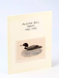
1992131j2479Canada: Bau-Xi Gallery. 1992. First Edition. Paperback. 0969678002 . "Bell perhaps more than any other B.C. artist is dedicated to the idea of the print - the multiple original created from a matrix designed and executed by the artist. In a time when the whole issue of prints and printmaking is a confusing babble of signed photo-mechanically produced reproductions Bell's woodcuts etchings engravings and drypoints sing out with a clarity and integrity." - Ian Thom. "Alistair Bell played an important role in the development of a distinctly west coast artistic sensibility known today as West Coast Modernism." - Ignite the Arts website. Bilingual English/French text. 48 glossy unnumbered pages. Illustrated in colour and black and white. Tight and unmarked with light wear. A quality example. ; 4to . Bau-Xi Gallery paperback
1975819621975 Montréal, Editions Fides (Collection du Goeland), 1975, in 8° broché, 133 pages ; couverture illustrée en couleurs.
1984072435Bethune SK: Bethune & District Historical Society 1984. Hardcover. pp. viii 392. 4to. Navy imitation leather binding with gilt lettering to spine and front board. Black and white illustrations. Moderate shelfwear slightly shaken bumping to extremities. Minor spotting to first few pages ink notation to title page; very good-. Bethune & District Historical Society hardcover
200917436Paris, Rombaldi, éditeur, 1939 ; in-8, 202 pp., demi-velin a coins dos illustrré en bel état. Sans rousseurs - composition originales en couleurs de Eugène Corneau - exemplaire n°1987 (récits du canada français).
201220284Ottawa, Association des brfaseries du canada, 1965 ; in-8, 142 pp., br. Broché très bon état.
59980London & New York: Witherby & Co. Charles Scribner’s Sons 1907. 8vo. 400 pp. Title in red & black. Photo frontisp. 64 plates. Green publisher’s cloth embossed gilt illust. of moose front cover gilt lettering on spine minor shelfwear dustsoiling slight fraying to rear outer hinge still VG copy. First edition of this noted big game hunter’s expeditions hunting moose near Lake Kippewa and portage to Lake Bois Franc; caribou in Newfoundland and St. John’s Lake; moose sheep & lynx in the Yukon Klondike and along the Macmillan River with specific mentions of hunting with Indigenous Peoples. Witherby & Co., Charles Scribner’s Sons, hardcover
ORD-1461Paris. 1914. Gd in-8 (220 x 280mm) percaline rouge brique imprimée de l'éditeur, 176 pages, 9 cartes couleurs plusieurs fois dépliantes des Chemins de Fer des Etats-Unis et du Canada. Une carte lgt froissée sinon bon exemplaire. On joint divers prospectus de la banque dont les cotes des principales opérations pour le 10 mai 1920 (4 pages in-4).
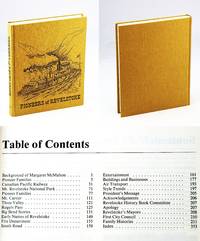
1986765j1516Revelstoke British Columbia: Revelstoke Senior Citizen Association. Fine. 1986. First Edition. Hardcover. 088925401X . Presents the local history of Revelstoke British Columbia. "Dedicated to our pioneers who opened up this country. To those that settled at Second Crossing as Revelstoke was first called. To the men that came with the building of the Canadian Pacific Railway bringing their wives from many countries to men and women who cleared the land south of here with stumping powder and a horse and often oxen." - page ii. Includes over 140 pages of family histories. Generously illustrated with black and white reproductions of archival photos. Map endpapers. 354 pages. Index. Clean bright tight and unmarked with negligible wear. An excellent example. Gift quality. Hale & Barman 142.; 4to . Revelstoke Senior Citizen Association hardcover
1987099259Cadillac Saskatchewan: Cadillac And District History Book Association 1987. Hardcover. pp. x 707. 4to. Bound in brown buckram with gilt lettering and decoration to spine and front board. Map and pictorial endpapers. Black and white photographs maps illustrations chart and tables etc. Minor shelfwear front board slightly bowed; very good. Cadillac And District History Book Association hardcover
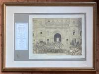
1912115761912. Original Print. Matted framed photograph. Very Good. Original back & white platinum photo print mounted on a period mat board stamped "Larrigan / Victoria" and framed within an additional mat board all within a 17 x 12.5 inch wood frame. Small dampstain the size of a US dime at lower margin. Prince Arthur Duke of Connaught 1850-1942 Queen Victoria's third and reportedly favorite son served as Governor-General of Canada 1911-1912. In 1887 he married Princess Louise Margaret of Prussia 1860-1917. The photo reveals the preposterous panoply of personalities who turned out for the Governor's visit many presumably being representatives of religious flocks including grey-bearded eastern-orthodox elders fraternal organizations including two exalted potentates with black-eyes who are connected at the neck by a drooping chain musicians a marching band is present political figures in formal attire et al. unknown
1931111275Toronto, Canada, Specification Data , Limited 1931 In-4 29 x 23,5 cm. Cartonnage éditeur souple percaline verte, dos lisse, titre doré sur le premier plat, XXXVI-305-74 pp., abondamment illustré. Exemplaire en bon état.
36090P., Editions du Carrefour, sans date (vers 1950), in 8° carré, broché, VIII-270 pages ; cachets ; dos grossièrement recollé ; couverture fanée.
192850929Victoria BC: The Fred Cox Service Ltd. label pasted over British Columbia Advertisers Engineering & Architectural Design Dept. ca. 1928. One oblong atlas folio map. 42 x 28.5 in. when unfolded 5 x 10.75 in. when folded. Printed in red white & blue w/ roads indicated in red. Preserved in original advertising map folder tan covers printed in red on front & back advertising Gutta Percha Tires and the Auto Service Club of British Columbia minor chipping to corners of covers toning; map w/ couple very small closed tears at creases very slight wear still VG- copy w/ ink annotations on back cover of folder. First edition of this scarce automobile travel map through the Pacific Northwest and British Columbia during the Roaring 20s with detailed mileage indicated between destinations. There is inset detail map of the Peace River District and Peace River Block West to Hudson Hope showing roads and trails. Worldcat locates 1 copy Univ. of Wash. The Fred Cox Service, Ltd., label pasted over British Columbia Advertisers, Engineering & Architectural Design Dept., unknown
192854283Quebec Canada: Canadian Pacific Jan. 1928. Folio. 9.25 x 12.25 in. 8 pp unpaginated. Illust. title in blue & black 3 floor plans blue printed borders printed in blue & black. Textured blue embossed illustrated softcovers cover art of Chateau Frontenac on front cover blue & gilt lettering sewn w/ green silk braid at spine minor edgewear rubbing minor dampsoiling to verso of front cover faint rust mark at gutter margin from staple still VG- copy. First edition of this scarce souvenir brochure issued for hotel guests in this splendid Canada’s grand railway hotel after the upgrading and remodeling of the luxurious hotel in 1924 by William Sutherland Maxwell. Worldcat locates 2 copies Archives du Quebec Canadian Centre for Architecture. Canadian Pacific, paperback
62117Edmonton Alberta Canada: The Douglas Printing co. Ltd. 1959. Tall 8vo. 236 2 pp. Numerous photo plates plates 1 large folding map. Blue publisher’s cloth gilt lettering on spine minor bumping to a couple corners minor soiling to fore-edges w/ d.j. cover art photo of the Canadian Pacific Railway survey in 1872 minor toning to fore-edges some scuffing still VG/VG copy signed by the author on rear endpapers. First edition signed of this informative and well-illustrated follow-up history of Fort Edmonton and Edmonton drawing from Frank Oliver’s writings the Hardisty family records and Sir Donald A. Smith. The Douglas Printing co., Ltd., hardcover
62116Edmonton Alberta Canada: The Douglas Printing co. Ltd. 1954. Tall 8vo. 255 1 pp. Numerous photo plates plates 1 large folding map. Blue publisher’s cloth gilt lettering on spine minor bumping to a couple corners still VG copy. First edition of this informative and well-illustrated historyof Fort Edmonton and Edmonton including the Hudson’s Bay Co. The Northwesters and more. Detailed are the efforts of Samuel Hearne Alexander MacKenzie the formation and influence of Fort Saskatchewan Fort Edmonton Fort Vancouver John McLoughlin and more. The Douglas Printing co., Ltd., hardcover
188558338Port Hawkesbury Inverness Nova Scotia: n.p. ca. 1885. Four mounted albumen photos including three cabinet card sized photos w/ images sized 3.75 x 6.2 in. mounted on 4.25 x 6.5 in. brown boards gilt lettering stamped at lower fore-edges 1 small 3.25 x 3.25 in. photo on 5 x 5 in. gray studio mount card stock all w/ annotations on versos indicating locations and w/ manuscript greetings some soiling dustsoiling and minor spotting to the Cabinet photos the smaller image a tad over-exposed still all three with fairly good contrast and well-defined images. These scarce images depict the town and harbour of Port Hawkesbury situated along the Strait of Canso and the only really viable port along the strait which faced Point Tupper. Originally named Ship Harbour the town supplied men materials and repairs to the Gulf of St. Lawrence fishing fleet and two of these images show vessels either anchored or under sail. These cabinet photos appear to have been sent to “Angus†as “Pictures of ‘home dear home’†with manuscript notes indicating “Port Hawkesbury looking towards Pt. Tupper. . . from Pt. Tupper. . . across the harbour.†The final photo shows the small Langley family home built by John Langley 1849-1926 who had married Maria Ballieul Langley 1848-1925 in 1872. He was initially a barrel cooper and later ship’s carpenter boat builder and later a railway foreman. n.p., hardcover
192559066Vancouver B.C.: Board of Park Commissioners Park Board Offices 1925. 8vo. 70 pp. Colour frontisp. numerous photo plates 1 large folding colour map. Tan colour-illustrated softcovers Arts & Crafts cover art of swans swimming in park lake yapp fore-edge minor creasing & edgewear creasing to a few corners minor fold creases at fore-edge of folding map still a VG copy. First edition of this work illustrating and outlining many of the improvements and changes brought to Stanley Park during the first decade of Rawlings 1882-1937 as Park Superintendent. These changes included the construction of the Lost Lagoon Lake saltwater pipes were shut off turning it into a freshwater lake with many other changes. This work also details several other newly acquired parks during the Progressive Era as well as improvements initiated for beach access bathing facilities and upgrades for automobile tours. See: Christina Cameron Jim Barlow & Susan Mundick Stanley Park National Historic Site of Canada Commemorative Integrity Statement 2004. Board of Park Commissioners, Park Board Offices, paperback
193459558Boston: Meador Publishing Co. 1934. 8vo. 271 1 pp. Red-ribbed publisher’s cloth black lettering front cover & spine w/ d.j. wraparound cover art of bucking bronco slight shelfwear toning still NF/NF copy. First American edition of this thrilling Western set in Saskatchewan against the backdrop of prairie fires stampedes wolves cattle-rustlers and gun-play. With parts in Western dialect the author recounts the homesteading days of Northwest Canada. See: Peel’s Bibliography of the Canadian Prairies to 1953 5800. Meador Publishing Co., hardcover
189952956Victoria BC: Victoria Sealing Co. Dec. 27 1899. One albumen photo sized 3.75 x 4.75 in. mounted on thick board sized 4.25 x 5.25 in. sepia-tinted image minor scuffing edgewear very minor dustsoiling back still VG image. Scarce original albumen photograph of the sealing Schooner Penelope which began sealing voyages on the Pacific Coast in 1885 and continued till foundering off Clallam Bay WA in the Straits of Juan de Fuca in 1904. The image shows the Victoria Sealing Company schooner under full sail leaving Kyuquot Sound on the west coast of Vancouver Island with buildings in the background. The sealing industry in British Columbia was under great pressure from the U.S. Government as it wished to protect its’ sealing monopolies in Alaska. See: Stephen Lunsford Agreement and Account of Crew for Schooner Penelope Univ. of British Columbia Library; Wright Lewis & Dryden’s Marine History of the Pacific Northwest pp. 210 450-51. Victoria Sealing Co., unknown
188755678Victoria New Westminster & Vancouver B.C.: The British Columbia Stationery & Printing Co. ca. 1887. 8vo. 5.75 x 7.6 in. 16 leaves unpaginated. sepia-tinted lithographed images bound leporello accordion style w/ 68 different images all w/ white & red borders. Embossed pebbled red publisher’s cloth gilt lettering front cover blind embossed raised borders very minor shelfwear 1 leaf w/ lifting from facing litho 1 very minor closed tear still a VG bright copy. First edition of this beautifully printed and illustrated souvenir book issued by the noted British Columbia printing firm which operated from 1885 to 1888 in Victoria and Vancouver BC. The views include the Victoria harbour the Fraser River Lighthouse birds-eye views of New Westminster Vancouver Coal Mining Co.’s Shaft No. 1 in Nanaimo the dockyards at Esquimalt Native American carvings totem poles and tribes people along with views of Sitka Alaska. Ferguson partnered with Pearson Robson & Hart in May 1886 to form the British Columbia Printing Co. who intended to establish themselves as the leading stationer printers in the province but due to the destruction of the company’s Vancouver branch by fire June 13 1886 and then on Sept. 1 1886 in Victoria but even though the company reconstituted and continued with their contract to print the West Shore Magazine locally as well as Canadian Pacific Railway literature the firm only survived until November 1888 when Ferguson returned to Winnipeg to open a book and stationery store. Worldcat locates 2 copies UBC WSU; See: Lana Okerlund British Columbia Stationery and Printing Company A Most Agreeable Place History of Booksellers and Stationers in British Columbia Oct. 3 2017; The West Shore Vol. 1 Vol. 13 1887 p. 496. The British Columbia Stationery & Printing Co., hardcover
187551587Montreal Toronto & London: George N. Tackabury Printed by the Burland-Desbarats Lithographic Co. 1875. Folio. 14.25 x 17.75 in. 251 1 pp. Colour lithograph illustrated title page showing the Parliament Building in Ottawa Canada from photograph by W. Notman 53 colour lithograph maps many double-page many tables. Publisher’s plum-coloured embossed cloth gilt decorative lettering on front cover marbled endpapers nicely rebacked in simulated black calf corners renewed some wear & rubbing to corners 1 leaf w/ repairs to creases minor tidemark to upper right corner not affecting maps still G copy. First edition of this fine atlas of Victorian-era Canada including maps of climatology possessions provinces prior to Alberta Saskatchewan & Newfoundland becoming provinces plat maps of counties Railways as well as maps of the United States and Europe. Of particular interest are the city maps of Quebec Ottawa London Hamilton Kingston Toronto and Montreal. This excellent reference work also provides a comprehensive list of railways in Canada steamships in use lists post offices railway stations cities and populations as well as business cards located by city and town. George N. Tackabury, [Printed by the Burland-Desbarats Lithographic Co.], hardcover