[Florida]Biblio.com

2 245 résultats
191640731Washington D.C.: Published by the United States Coast and Geodetic Survey 1916. Large folding nautical chart printed on heavy paper stock. Uncolored with minor wear. A rare original coastal survey of Florida along Everglades National Park and including Marco Island.<br/> <br/> Established by President Thomas Jefferson in 1807 as the Survey of the Coast the U.S. Coast and Geodetic Survey was the United States' first civilian scientific agency. This agency has followed its mission to survey the U.S. coastline create nautical charts of the coast and help increase maritime safety since its founding and has often played fascinating roles in significant chapters of U.S. history. It served in all theaters of the Civil War in the service of the Union Army and Navy pioneered acoustic exploration in the wake of the sinking of the Titanic and during WWI it worked to detect enemy submarines. In addition this agency worked to survey and produce detailed maps and renderings of the U.S. coast. These nautical survey maps commonly referred to as "T-sheets" provide fascinating insights into the history of the United States coastline which has and will continue to shift. These maps are the most important data source for understanding the physical and ecological characteristics of the U.S. shoreline. The present map is a highly detailed and accurate sea chart of the Everglades National Park and an important historical view of a developing Florida. Published by the United States Coast and Geodetic Survey unknown
192040702Washington D.C.: Published by the United States Coast and Geodetic Survey 1920. Large folding nautical chart printed on heavy paper stock. Colored with minor wear. A rare coastal survey of Florida around St. Augustine including Vilano Beach St. Augustine Beach Butler Beach Crescent Beach Palm Coast and Ormond Beach.<br/> <br/> Established by President Thomas Jefferson in 1807 as the Survey of the Coast the U.S. Coast and Geodetic Survey was the United States' first civilian scientific agency. This agency has followed its mission to survey the U.S. coastline create nautical charts of the coast and help increase maritime safety since its founding and has often played fascinating roles in significant chapters of U.S. history. It served in all theaters of the Civil War in the service of the Union Army and Navy pioneered acoustic exploration in the wake of the sinking of the Titanic and during WWI it worked to detect enemy submarines. In addition this agency worked to survey and produce detailed maps and renderings of the U.S. coast. These nautical survey maps commonly referred to as "T-sheets" provide fascinating insights into the history of the United States coastline which has and will continue to shift. These maps are the most important data source for understanding the physical and ecological characteristics of the U.S. shoreline. The present map is a highly detailed and accurate sea chart of St. Augustine area and an important historical view of a developing Florida. Published by the United States Coast and Geodetic Survey unknown
192040728Washington D.C.: Published by the United States Coast and Geodetic Survey 1920. Large folding nautical chart printed on heavy paper stock. Colored with minor wear and small loss to the top margin. A rare original coastal survey of the St Johns River and Lake George in north-central Florida bisected into two parts.<br/> <br/> Established by President Thomas Jefferson in 1807 as the Survey of the Coast the U.S. Coast and Geodetic Survey was the United States' first civilian scientific agency. This agency has followed its mission to survey the U.S. coastline create nautical charts of the coast and help increase maritime safety since its founding and has often played fascinating roles in significant chapters of U.S. history. It served in all theaters of the Civil War in the service of the Union Army and Navy pioneered acoustic exploration in the wake of the sinking of the Titanic and during WWI it worked to detect enemy submarines. In addition this agency worked to survey and produce detailed maps and renderings of the U.S. coast. These nautical survey maps commonly referred to as "T-sheets" provide fascinating insights into the history of the United States coastline which has and will continue to shift. These maps are the most important data source for understanding the physical and ecological characteristics of the U.S. shoreline. The present map is a highly detailed and accurate sea chart of the Lake George region and an important historical view of a developing Florida. Published by the United States Coast and Geodetic Survey unknown
191640686Washington D.C.: Published by the United States Coast and Geodetic Survey 1916. Nautical chart printed on heavy paper stock. Colored. A rare coastal survey of the St. Johns River near Orlando with an inset map of the river continuation in the bottom left corner.<br/> <br/> Established by President Thomas Jefferson in 1807 as the Survey of the Coast the U.S. Coast and Geodetic Survey was the United States' first civilian scientific agency. This agency has followed its mission to survey the U.S. coastline create nautical charts of the coast and help increase maritime safety since its founding and has often played fascinating roles in significant chapters of U.S. history. It served in all theaters of the Civil War in the service of the Union Army and Navy pioneered acoustic exploration in the wake of the sinking of the Titanic and during WWI it worked to detect enemy submarines. In addition this agency worked to survey and produce detailed maps and renderings of the U.S. coast. These nautical survey maps commonly referred to as "T-sheets" provide fascinating insights into the history of the United States coastline which has and will continue to shift. These maps are the most important data source for understanding the physical and ecological characteristics of the U.S. shoreline. The present map is a highly detailed and accurate sea chart of the St Johns River and an important historical view of a developing Florida. Published by the United States Coast and Geodetic Survey unknown
191640716Washington D.C.: Published by the United States Coast and Geodetic Survey 1916. Large folding nautical chart printed on heavy paper stock. Uncolored. A rare original coastal survey of the St. Johns River from Jacksonville to Fleming Island.<br/> <br/> Established by President Thomas Jefferson in 1807 as the Survey of the Coast the U.S. Coast and Geodetic Survey was the United States' first civilian scientific agency. This agency has followed its mission to survey the U.S. coastline create nautical charts of the coast and help increase maritime safety since its founding and has often played fascinating roles in significant chapters of U.S. history. It served in all theaters of the Civil War in the service of the Union Army and Navy pioneered acoustic exploration in the wake of the sinking of the Titanic and during WWI it worked to detect enemy submarines. In addition this agency worked to survey and produce detailed maps and renderings of the U.S. coast. These nautical survey maps commonly referred to as "T-sheets" provide fascinating insights into the history of the United States coastline which has and will continue to shift. These maps are the most important data source for understanding the physical and ecological characteristics of the U.S. shoreline. The present map is a highly detailed and accurate sea chart of St. Johns River around Jacksonville and an important historical view of a developing Florida. Published by the United States Coast and Geodetic Survey unknown
192140694Washington D.C.: Published by the United States Coast and Geodetic Survey 1921. Nautical chart printed on heavy paper stock. Colored. A rare coastal survey of Florida including Laguna beach Panama City Mexico Beach and Cape San Blas.<br/> <br/> Established by President Thomas Jefferson in 1807 as the Survey of the Coast the U.S. Coast and Geodetic Survey was the United States' first civilian scientific agency. This agency has followed its mission to survey the U.S. coastline create nautical charts of the coast and help increase maritime safety since its founding and has often played fascinating roles in significant chapters of U.S. history. It served in all theaters of the Civil War in the service of the Union Army and Navy pioneered acoustic exploration in the wake of the sinking of the Titanic and during WWI it worked to detect enemy submarines. In addition this agency worked to survey and produce detailed maps and renderings of the U.S. coast. These nautical survey maps commonly referred to as "T-sheets" provide fascinating insights into the history of the United States coastline which has and will continue to shift. These maps are the most important data source for understanding the physical and ecological characteristics of the U.S. shoreline. The present map is a highly detailed and accurate sea chart of BLANK and an important historical view of a developing Florida. Published by the United States Coast and Geodetic Survey unknown
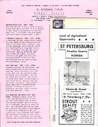
77880Small packet of materials concerning investment opportunities in St. Petersburg Florida mailed by Strout Realty to Mr. and Mrs. Ray Spencer of Delavan Wisconsin on March 22 1957. The contents consist of an informational brochure about the city and a detailed list with pricing information for fifteen "Strout Bargains" in St. Petersburg. Four of the properties are marked "Sold" and there is a holographic correction to the price of the final listing: "A Retirement Gem" for $3950. Located on the Pinellas peninsula between Tampa Bay and the Gulf of Mexico "St. Pete" experienced a population boom during the 1950s with the return of retiree resettlement which had declined precipitously during the Great Depression. At this same time as the brochure notes there was "increasing demand for Florida citrus products" which attracted many small farmers to the region. unknown
191640706Washington D.C.: Published by the United States Coast and Geodetic Survey 1916. Large folding nautical chart printed on heavy paper stock. Colored. A rare coastal survey of Tampa Bay including Tampa St. Petersburg Clearwater Anna Maria Island and Bradenton.<br/> <br/> Established by President Thomas Jefferson in 1807 as the Survey of the Coast the U.S. Coast and Geodetic Survey was the United States' first civilian scientific agency. This agency has followed its mission to survey the U.S. coastline create nautical charts of the coast and help increase maritime safety since its founding and has often played fascinating roles in significant chapters of U.S. history. It served in all theaters of the Civil War in the service of the Union Army and Navy pioneered acoustic exploration in the wake of the sinking of the Titanic and during WWI it worked to detect enemy submarines. In addition this agency worked to survey and produce detailed maps and renderings of the U.S. coast. These nautical survey maps commonly referred to as "T-sheets" provide fascinating insights into the history of the United States coastline which has and will continue to shift. These maps are the most important data source for understanding the physical and ecological characteristics of the U.S. shoreline. The present map is a highly detailed and accurate sea chart of Tampa Bay and an important historical view of a developing Florida. Published by the United States Coast and Geodetic Survey unknown
191540709Washington D.C.: Published by the United States Coast and Geodetic Survey 1915. Large folding nautical chart printed on heavy paper stock. Colored. Coastal survey map encompassing Tampa Bay up to Cape San Blas including St. Petersburg Tampa Clearwater St. George Island and Cedar Keys.<br/> <br/> Established by President Thomas Jefferson in 1807 as the Survey of the Coast the U.S. Coast and Geodetic Survey was the United States' first civilian scientific agency. This agency has followed its mission to survey the U.S. coastline create nautical charts of the coast and help increase maritime safety since its founding and has often played fascinating roles in significant chapters of U.S. history. It served in all theaters of the Civil War in the service of the Union Army and Navy pioneered acoustic exploration in the wake of the sinking of the Titanic and during WWI it worked to detect enemy submarines. In addition this agency worked to survey and produce detailed maps and renderings of the U.S. coast. These nautical survey maps commonly referred to as "T-sheets" provide fascinating insights into the history of the United States coastline which has and will continue to shift. These maps are the most important data source for understanding the physical and ecological characteristics of the U.S. shoreline. The present map is a highly detailed and accurate sea chart of the coast of Florida from Tampa Bay to Cape San Blas and is an important historical view of the developing state. Published by the United States Coast and Geodetic Survey unknown
191740713Washington D.C.: Published by the United States Coast and Geodetic Survey 1917. Large folding nautical chart printed on heavy paper stock. Uncolored. Coastal survey map of Tortugas Harbor and approaches with an inset map in the upper left corner of Fort Jefferson.<br/> <br/> Established by President Thomas Jefferson in 1807 as the Survey of the Coast the U.S. Coast and Geodetic Survey was the United States' first civilian scientific agency. This agency has followed its mission to survey the U.S. coastline create nautical charts of the coast and help increase maritime safety since its founding and has often played fascinating roles in significant chapters of U.S. history. It served in all theaters of the Civil War in the service of the Union Army and Navy pioneered acoustic exploration in the wake of the sinking of the Titanic and during WWI it worked to detect enemy submarines. In addition this agency worked to survey and produce detailed maps and renderings of the U.S. coast. These nautical survey maps commonly referred to as "T-sheets" provide fascinating insights into the history of the United States coastline which has and will continue to shift. These maps are the most important data source for understanding the physical and ecological characteristics of the U.S. shoreline. The present map is inset with a detailed view of Fort Jefferson on Garden Key. Fort Jefferson was an ambitious civil war era coastal defence site which became the largest brick structure in the US. This map is a highly detailed and accurate sea chart of Tortugas Harbor and an important historical view of a developing Florida. Published by the United States Coast and Geodetic Survey unknown
191640722Washington D.C.: Published by the United States Coast and Geodetic Survey 1916. Large folding nautical chart printed on heavy paper stock. Uncolored. A rare original coastal survey of the central Florida coast around Cedar Keys.<br/> <br/> Established by President Thomas Jefferson in 1807 as the Survey of the Coast the U.S. Coast and Geodetic Survey was the United States' first civilian scientific agency. This agency has followed its mission to survey the U.S. coastline create nautical charts of the coast and help increase maritime safety since its founding and has often played fascinating roles in significant chapters of U.S. history. It served in all theaters of the Civil War in the service of the Union Army and Navy pioneered acoustic exploration in the wake of the sinking of the Titanic and during WWI it worked to detect enemy submarines. In addition this agency worked to survey and produce detailed maps and renderings of the U.S. coast. These nautical survey maps commonly referred to as "T-sheets" provide fascinating insights into the history of the United States coastline which has and will continue to shift. These maps are the most important data source for understanding the physical and ecological characteristics of the U.S. shoreline. The present map of the Florida coastline precedes the inclusion of Yankeetown; chartered in 1923 and the site of one of only two completed sections of the proposed Cross Florida Barge Canal. This map is a highly detailed and accurate sea chart of the central Florida coastal region and an important historical view of a developing Florida. Published by the United States Coast and Geodetic Survey unknown
183932262New York: Wiley and Putnam 1839. First Edition. Hardcover. Good. Small octavo. 1 xii 13-199 pages 1. Brown cloth hardcover with gilt lettered title on the spine. The brown cloth is faded and creased with a few light spots and edge wear head and base of the spine. Light to moderate scattered foxing and toning to the contents. Previous owner name on the front paste down. No author name indicated. <br /> <br /> Clark Old South III 257; Sabin 104829. Wiley and Putnam hardcover
189059940Key West FL: Hunt Photographer 211 Duval St. ca. 1890. Oblong 8vo. One albumen photo sized 4.25 x 6.5 in. mounted on printed 5.25 x 8.5 in. boudoir-sized studio board w/ photographer’s imprint in lower margin of board manuscript pencil title on verso minor chipping & slight tears to upper fore-edge of image still a VG- photo w/ bright strong contrast. A scarce 19th-century albumen boudoir photograph capturing the historic fish market in Key West Florida which at the time held a monopoly on the sponge trade in the United States. Beginning with sponges introduced before the Civil War eventually 1200 spongers on hook boats caught up to 2000 tons of sponges a year. At the time turtling or turtle fishing was a significant industry and the Charter Fishing Boat presence was still quite small and would eventually grow during the Progressive Era drawing ever greater numbers of tourists. Hunt fl. 1880-1900 in Key West Florida operated a photography studio at 211 Duval for over a decade and was originally from Indiana. Hunt, Photographer, 211 Duval St., unknown
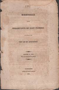
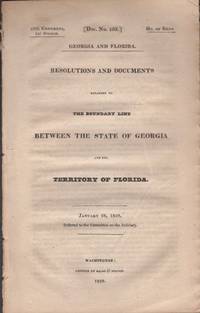
182332839Washington DC: Printed by Gales & Seaton 1823. First Edition. Wraps. Good. Disbound wraps. 5 pages 1 blank page. Printed name of Waters Smith at the bottom page 5 and attested by the Secretary F. J. Fatio. Scarce. 2 copies located in OCLC as of 4/2019 Jacksonville PL AAS. Florida became a territory of the United States in 1822 and obtained statehood in 1845. Printed by Gales & Seaton unknown
1863D19919Florida: Munsell San Augustin de la Florida 1863. Poor. One of 160 copies. Defective disbound without only remnants of original wraps. Sold as is. "The unknown author of this authoritative account of Sonora is thought to have been a Jesuit missionary named Juan Nentuig who reached Sonora in 1750. From a reference on p. 196 it must have been written as late as November 21 1762. Nentuig remained until the expulsion of the Jesuits in 1767. The false imprint of Saint Augustine Florida on the title derives from Buckingham Smith's pride in his home town" - Streeter. "The author resided at a place on the River Yaqni where that stream flows through a cañon so deep as to shut out three quarters of the heavens from sight. The first sixty-nine pages are occupied with a natural history of the country .The subjects relating to the Indians occupy pp.69 to 173" - Field. <br/><br/> Munsell, San Augustin, de la Florida paperback
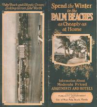
34507West Palm Beach: City of West Palm Beach Florida n.d. Brochure. Good. Folded brochure. Vintage brochure measures 9" x 4" when folded. 28 pages. Illustrated with black and white photographs of hotels buildings the beach etc. Color illustration on the front cover and aerial photograph of the city on the back cover. A few spots to the contents. Good condition. City of West Palm Beach, Florida unknown
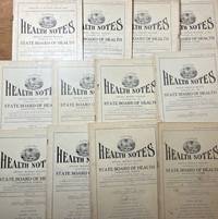
192934381Jacksonville: State Board of Health 1929. Periodical. Good. Incomplete run of 27 periodicals titled the Florida Health Notes. Issues are mostly in good condition with some minor edge tears toning and light foxing. A front cover of one issue is detached. Articles cover malaria and mosquitos rabies fatal automobile accidents vaccine population data mortality marriages and divorces and several other subjects. State Board of Health unknown
193135982Chapel Hill: The University of North Carolina Press 1931. First Edition. Hardcover. Good. Octavo. xvi 165 pages. Illustrated by Louise Turck. Red cloth covered boards with gilt and red embossed illustration block on front cover. Vellum spine with gilt stamped title. Illustrated end sheets. Top edge gilt. Untrimmed foredge. Light shelf and edge wear to the red cloth binding. A few tiny pin holes on the vellum front outer joint. Limited to 212 copies and printed on Hadrian vellum paper. This copy signed by the author and numbered 176. The University of North Carolina Press hardcover
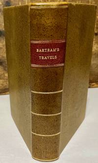
179330176Dublin: For J. Moore W. Jones R. McAllister and J. Rice 1793. Later printing. Leather bound. Very good. Octavo. xxiv 520 pages 11 page index directions to the binder. Frontispiece engraving of Mico Chlucco. Illustrated with 7 plates one folding and one folding map. Later speckled calf leather binding with red leather title label on spine. Newer front and rear end sheets added. Newer head bands top and bottom of text block. Light foxing to frontispiece engraving and title page. Light scattered occasional foxing to the contents. This edition follows the Philadelphia 1791 first edition and the first English edition of 1792. Bartram's classic account of southern natural history native Americans and exploration in the southeastern states during the American Revolution period. <br /> <br /> Howes B 223; Field 94; Sabin 3870; Clark I 197; De Renne Vol. 1 p.257; See Field 96. For J. Moore, W. Jones, R. McAllister, and J. Rice unknown
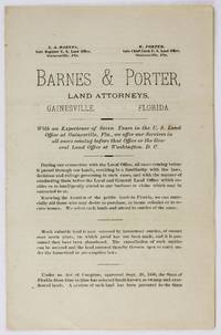
18903620Gainesville Fl: Daily Advocate Job Print 1890. Very good. 4pp. on a single folded sheet. Mild soiling minor toning old folds. A seemingly unrecorded real estate promotional leaflet issued by Louis A. Barnes and Watson Porter local land attorneys working in and around Gainesville Florida. The pair is seeking prospective purchasers for "much valuable" homestead lands now available for settlement again after being abandoned "under the homestead or pre-emption laws." They also offer services for claims on "Spanish Grants" land warrants soldiers' homestead rights and more. Interestingly one of the two lawyers here Watson Porter previously served as a surgeon in the Third U.S. Colored Troops. In Florida Porter and his wife Olivia established O.A. Porter's Addition to Gainesville selling lots exclusively to African-American people who did not have ready access to land or financing; the neighborhood survives today in Gainesville as Porters Quarters. Porter also served as the Principal of the Union Academy a freedman's school and was a strong supporter of Josiah T. Walls the only African-American man from Gainesville to be elected and seated twice to the U.S. House of Representatives. Some of the land and services in question in the present pamphlet were almost certainly provided to African-American settlers. The pamphlet was printed by the Gainesville-area Daily Advocate which operated in the area between 1884 and 1890. No copies located in OCLC. Daily Advocate Job Print unknown
188944906Boston: Little Brown and Co. 1889. 8vo. xviii 19-200 pp. Chromolith colour frntsp. 3 chromolith colour plates 2 tinted etchings 59 text woodcut engravings historiated vignettes and plates. Contemporary full brown morocco raised bands gilt lettrng on spine gilt inner ruling & dentelle marbled endpapers a.e.g. signed MacDonald & Sons on verso of ffep vry slght sunng to spine vry slght shlfwr NF copy w/ frmr ownrshp inscrptn on ffep. First edition of this beautifully illustrated book in a fine period binding by the famed Boston book binding firm. Deland 1857-1945 writes this early travel account through St. Augustine and along the St. Johns River in the 1880s including vivid reminiscences of the scenery natural history and the local people of the time some of it in dialect. Louis Kinney Harlow 1850-1913 was an exceptional New England landscape artist noted for his paintings and etchings at the end of the 19th century had moved to Boston in the mid-1880s in order to advance his career. Little, Brown, and Co., hardcover
192655884New York: Harper & Brothers 1926. 8vo. xiv 324 pp. plus 2 pp. publisher’s ads. Photo frontisp. numerous photo plates. Green cloth gilt lettering front cover & spine very minor rubbing slight frying at foot of spine very slight bumping to couple corners w/ d.j. splendid silhouette Art Deco cover art w/ initials RW minor tear at head of spine w/ very minor loss minor sunning still VG/VG- copy. First edition of this fascinating memoir tracing the impact of the Jazz Age on Florida development regaling readers with accounts of the great land rush and crowded steamers headed southward automobile travelers filling nascent highways and the drama of the real estate developers in Miami Coral Gables Hollywood and Boca Raton. Included as well are accounts of the bootleggers gamblers real estate scams and the boom days of the 1920s before the crash of 1929. Exceedingly scarce in original dustjacket. Harper & Brothers, hardcover
193857192New York: Sheridan House 1938. 8vo. 287 1 pp. Numerous photo plates colour maps on endpapers. Forest-green tweed boards black lettering colour maps on endpapers minor bumping head of spine slight bumping to couple corners w/ d.j. cover art of the Gypsy Waters under sail couple minor closed tears edgewear still VG/VG- copy. First edition of this author’s memoir detailing the rebuilding and outfitting of a Chesapeake Bay Bugeye ketch he renamed Gypsy Waters and the several adventures with his family to the Bahamas the Gulf Islands the Gulf lakes and rivers of Florida and more. Scarce in original dustjacket. Sheridan House, hardcover
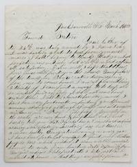
18584106Jacksonville Fl: March 15 1858. Very good plus. 4pp. on a single folded sheet. Old mailing folds. An informative dispatch from antebellum Florida from A.C Scranton to "Friend Barton" in 1858. In his letter Scranton reports that despite some problems he is enjoying southern people and general life in Florida: "The people generally in the south are very kind & hospitibal but I need hardly to tell you that Florida has got some hard times as every new state or Territory has but thare is a more healthy Emigration coming in every year I have been fortunate anough to find some Northern people here which makes it seam a little more like home to me. I am boarding with a family from Georgia whome I like first rate & I do just as I would at home so that things are quite pleasant here considering I am amongst strangers."<br /> <br /> He then provides information on Jacksonville and then two disasters that hit his adopted hometown: "Jacksonville is the largest place in Florida & had at one time about 3000 inhabitants it is not as large as it was once some three years ago it was visited by a very destructive fire & burned nearly half of the town. Last summer there was some kind of Fever here that almost prostrated the place some called it the Yellow Fever & some the African but none could tell for certin.about a hundred & fifteen or twenty that died here in 3 months & a grate many left the town nearly all the stors wer closed not a sound of a hammer was to be heard. When cold weather came it stoped the sickness and it seams quite lively now. It has been for many years a grate resort in the winter season for invaleds but on account of the sickness last summer thare are but few this winter if it continus healthy this summer the place will revive but if not it will kill it entirely."<br /> <br /> Scranton also discusses the transportation system that served Jacksonville and the recent winding down of the Seminole Wars: "It is situated on the Johns River about 23 miles from the mouth and is connected with Charleston & Savana by a regular line of steamers that runs up the river a hundred miles to a place called Platka whare Emigrants land & then travel by land to the interior to settle the country thare is a railroad building from this place to Tallahasse the capital of the state a distance of a hundred & eighty miles which wen completed will be a little help to this place. There is also another in progress from Fernandina a new town that lays in the North East corner of the state to a place called cedar keys on the gulf side whare they intend to carry the US mail direct from New Orleans to New York insted of going round by Key west & will shorten the time considerable. Florida has cost Uncle Sam a large some of money.the government.will make a treaty with them & send them into the Indian Territory & then close the Indian war in Florida." Almost all of the Seminoles remaining in Florida relocated to Indian Territory in the year this letter was written.<br /> <br /> A wonderfully-detailed firsthand account of Jacksonville and its development and challenges during the late 1850s. A printed transcription accompanies the letter. March 15 unknown
182834780Washington DC: Printed by Gales & Seaton 1828. Wraps. Very good. Disbound wraps. 21 pages 1 page. Contents clean Scarce. Printed by Gales & Seaton unknown