2 245 résultats
186334799Long Swamp Florida: n.p. 1863. Letter. Good. Manuscript letter written on blue paper. Approx. 10" x 8". 1 page of content. On the back side is written "J L McGahagin Seller Jany 25th 1863". Hand writing is difficult to read at times. Letter has multiple folds. The paper is in good condition with some small splits at the folds. Transcription below:<br /> <br /> Long Swamp Fla Jan 25th 1863<br /> Mr. H. L. Flast<br /> Dear Sir<br /> <br /> I received your letter with draft of $1500 on Maj Teasdale which I will not want to use at percent - 8 I was disappointed in getting the cotton at or near Wacahoota persons in that section have put is up to 45 cts I have about 15 Bales seed Cotton and 12 gined at Home. I will tomorrow to haul down more seed cotton which I think I will enough to make 20 Bales I went to Gainesville and got the draft of 1900 from Dawkins I will have to pay for cotton if I get any more at 'presant' I to pay 'presant' prices - I have not heard from the teacher as yet that you were to and we have an application from Miss Baker for a friends of hers and are waiting to hear from you let us hear soon<br /> <br /> Yours Respectfully signed J L McGahagin<br /> <br /> From find a grave dot com:<br /> <br /> His first wife Sarah Adeline Eubanks McGahagin 1830-1856 is buried on the north side of him. On his other side is his second wife Margaret Jane Leitner McGahagin 1838-1896. His brother William Emmit McGahagin and his brother’s wife Sarah Eliza McCormick McGahagin are buried about fifteen feet south of J.L. McGahagin's tombstone.<br /> Joshua L. McGahagin was a farmer a saw-mill owner and owned real estate. He owned property in Brazil as well as in this country. He owned a sawmill on Lake Weir. He would barge logs across the lake take them by ox cart to the Ocklawaha River where they were barged to Jacksonville. He was a Captain in the Confederate Army.<br /> <br /> "Longswamp was the name applied to a large area which extended from the site of the present Belleview south and southwestward to the Withlacoochee River. A post office under Joshua L. McGahagin was established for this region on August 29 1846. Frequently the office was in the home of the postmaster and mail was carried by rider once each week."<br /> <br /> "In August of 1850 panic followed after finding an Indian camp nearby on the Withlacoochee. As all Indians were supposedly within a reservation in the Everglades wild rumors were circulated. On the McGahagin plantation log barricades were hurriedly erected and settlers from isolated homes rushed here for protection. But the alarm was unjustified. An intensive search disclosed only eleven Indians. These Indians were soon deported back to the Everglades."<br /> <br /> These excerpts were taken from a history of Marion County called "Ocali Country Kingdom of the Sun" by Eloise Robinson Mrs. Roy V. Ott and Louis Hickman Chazal.<br /> <br /> One day several years after the Civil War a man who had served under Joshua Lucas MaGahagin's C.S.A. command entered the home of his eldest son William "Billy" Emmit. He saw his father's framed photograph over the mantel and exclaimed "Why that's the Ole Warhorse!"<br /> <br /> Joshua left for South America in 1868 taking one of his daughters Lula with him. He was back in Marion County in 1870 as he was listed in the Census that year.<br /> <br /> After surviving the Civil War and a trip to Brazil spending hours on horseback Joshua died when he was thrown from a horse. n.p. unknown
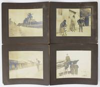
18905287Various locations in Cuba and Florida 1890. Very good. Twelve cabinet card photographs each measuring 3.5 x 4.5 inches on matching mounts measuring 5.25 x 6.5 inches all with manuscript captions on verso. Moderate dust-soiling minor overall wear a few small unobtrusive chips to corners. A dozen original photographs picturing a group of men traveling in Florida and Cuba around the turn of the 20th century. The men seem relatively well-to-do and visit several different locations in each place. Four of the photos emanate from Florida while the remainder picture scenes in Cuba. The photographs are all captioned on the verso which read as follows:<br /> <br /> 1 "In the Court of Ponce De Leon Hotel St. Augustine"<br /> 2 "A frozen fountain in St. Augustine Florida - the white is ice"<br /> 3 "Fishing in St. Augustine"<br /> 4 "A Tree in Tampa Florida where one tree runs up on another takes root up in tree then runs down & takes root in the ground again"<br /> 5 "A Street in Nevaelas Cuba"<br /> 6 "A Country Road in Cuba"<br /> 7 "Natives in Havana"<br /> 8 "In Morro Castle Havana Cuba. Prisoners braking sic rocks"<br /> 9 "On top of Morro Castle Havana Cuba"<br /> 10 "Country Scene in Cuba"<br /> 11 "Country Scene in Cuba" different image<br /> 12 "Plaza at south of the Prado Havana unknown
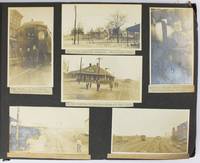
19095288Various locations mostly in Cuba and Florida: March 5 to April 1 1909. About very good. 21 leaves illustrated with 235 photographs all with typed captions. Oblong folio. Contemporary full dark brown cloth brad bound. Moderate staining and coiling to covers some edge wear. Bottom corners of all leaves chipped not costing content. Occasional minor wear to photos or captions. A well-organized and meticulously-captioned vernacular photograph album with significant content on Florida and Cuba in the first decade of the 20th century. The album is organized chronologically and features a family from Ohio traveling from home by train to Florida and thence to Cuba then returning home in the spring of 1909. The first seven and the last twenty-five photographs emanate from Ohio where the journey started Tennessee and Georgia but otherwise the album features Florida and Cuba in over 200 pictures. The scenes in Florida range from Jacksonville to Key West and other points in-between featuring the state in almost 120 photos both before and after the traveling party went to Cuba. The images capture portraits of the travelers numerous homes hotels businesses and other buildings including an ostrich farm in Jacksonville numerous scenes in Ocala including one image featuring "Mary and her old colored Mammy" various churches and other scenes in Tampa residences in Key West beach scenes at Long Key various hotels and agricultural fields in Miami and various buildings in Palm Beach Ormand and St. Augustine concluding with a front view of the "Old Slave Market" in the latter city.<br /> <br /> Most notably the album includes eighty-six photographs of Cuba the nexus point for the present trip where the party arrived on March 20. The Cuba scenes mostly feature Havana with several views of "Beautiful Residences" and other buildings plus some street views and other scenes in the city. Other interesting Havana scenes picture the railroad station "The Bone Yard -- Old destroyed Catacombs" scenes in the Malecon and more. Some of the street scenes in Havana picture local residents one of "Children on the street corner" and another showing "Children scrambling for pennies" in the middle of the street. The album also contains views of the wreck of the Maine Morro Castle the interior of Fort Cabanas and more. The travelers managed to wander outside Havana for a day when they ventured to the countryside and the town of Guines on March 23. While there the compiler took photographs of countryside outside Guines a railroad car full of sugar cane thatched houses a group photograph of the students at a "Spanish School in Guines" a "Child crying in the street" a group of locals outside a cafe captioned "Strangers in a strange land.Where we tried to get something to eat" other street scenes in the town and the local jail. The last photograph of Cuba here features a "Large Sugar Mill in Providencia." The group then returned through Florida Georgia and Tennessee where they spent a day at Lookout Mountain and Orchard Knob before their final stop in Dayton Ohio. A wonderful early-20th century travel album with significant views in Florida and Cuba. March 5 to April 1 unknown
200235761AB[Gütersloh], RM Buch und Medien Vertrieb, 2002. 22 cm, 384 Seiten, mit zahlreichen Farbfotos, Karten und Abbildungen, kartoniert, Englische Broschur, Karten auf den Vorsätzen. Ungekürzte Lizenzausgabe leichte Gebrauchsspuren, gut erhalten. Club-Reiseführer.
199841916ABRheda-Wiedenbrück, Bertelsmann Club, 1998. 22 cm, 672 Seiten, mit zahlreichen Farbfotos, Karten und Abbildungen, kartoniert, Englische Broschur, Karten auf den Vorsätzen. Ungekürzte Buchgemeinschafts-Lizenzausgabe, aktual insgesamt leichte Gebrauchsspuren, gut erhalten. Club-Reiseführer.
191940735Washington D.C.: Published by the United States Coast and Geodetic Survey 1919. Large folding nautical chart printed on heavy paper stock. Colored. A rare original coastal survey of Florida and Georgia from Sapelo Island to Amelia Island including St. Simons Island Sea Island Brunswick Jekyll Island Cumberland Island and Fernandina Beach.<br/> <br/> Established by President Thomas Jefferson in 1807 as the Survey of the Coast the U.S. Coast and Geodetic Survey was the United States' first civilian scientific agency. This agency has followed its mission to survey the U.S. coastline create nautical charts of the coast and help increase maritime safety since its founding and has often played fascinating roles in significant chapters of U.S. history. It served in all theaters of the Civil War in the service of the Union Army and Navy pioneered acoustic exploration in the wake of the sinking of the Titanic and during WWI it worked to detect enemy submarines. In addition this agency worked to survey and produce detailed maps and renderings of the U.S. coast. These nautical survey maps commonly referred to as "T-sheets" provide fascinating insights into the history of the United States coastline which has and will continue to shift. These maps are the most important data source for understanding the physical and ecological characteristics of the U.S. shoreline. The present map is a highly detailed and accurate sea chart of the coastal border between Georgia and Florida and an important historical view of the developing states. Published by the United States Coast and Geodetic Survey unknown
192140736Washington D.C.: Published by the United States Coast and Geodetic Survey 1921. Large folding nautical chart printed on heavy paper stock. Colored. A rare original coastal survey of Florida and Alabama from Pensacola Bay showing Perdido Bay including Pensacola Perdido Key and Orange Beach.<br/> <br/> Established by President Thomas Jefferson in 1807 as the Survey of the Coast the U.S. Coast and Geodetic Survey was the United States' first civilian scientific agency. This agency has followed its mission to survey the U.S. coastline create nautical charts of the coast and help increase maritime safety since its founding and has often played fascinating roles in significant chapters of U.S. history. It served in all theaters of the Civil War in the service of the Union Army and Navy pioneered acoustic exploration in the wake of the sinking of the Titanic and during WWI it worked to detect enemy submarines. In addition this agency worked to survey and produce detailed maps and renderings of the U.S. coast. These nautical survey maps commonly referred to as "T-sheets" provide fascinating insights into the history of the United States coastline which has and will continue to shift. These maps are the most important data source for understanding the physical and ecological characteristics of the U.S. shoreline. The present map is a highly detailed and accurate sea chart of the coastal border between Florida and Alabama and an important historical view of the developing states. Published by the United States Coast and Geodetic Survey unknown
192264060Tallahassee FL & Buffalo & New York NY: Department of Agriculture Florida The Matthews-Northrup Works 1922. One large oblong double-atlas folio colour lithograph map sized 50 x 44 in. county lines and railroad lines demarcated in colours fold creases as issued minor dustsoiling edgewear to verso some very slight weakening to a couple fold creases otherwise a VG bright copy. First edition thus of this uncommon and updated sectional map of Florida incorporating the 1920 census numbers as well as updating the agricultural statistics farm properties and average acreage values at the outset of the Roaring 20’s. Also delineated are the railroads reaching into Florida including the Atlantic Coast Line Florida East Coast RR Seaboard Air Lines Georgia Southern & FLorida RR Louisville 7 Nashville RR and others. McRae 1870-1943 headed the Florida Department of Agriculture from 1912-1923. Worldcat locates 2 physical copies U of FL WI Hist. Soc. Department of Agriculture, Florida, The Matthews-Northrup Works, unknown
191138867New York: Moffat Yard & Co. 1911. 8vo. 16 235 1 pp. Photo frntsp. numerous photo plates. Red cloth gilt lettrng plate of Chief Osceola on the frnt cvr rubbng edgewear still a G copy. Revised & expanded edition of this classic anthropological work written to support and help the few hundred surviving Seminole Indians of Florida at the end of the 19th-century. Moffat, Yard & Co., hardcover
1872361607Tallahassee FL: Charles H. Walton State Printer 1872. First Edition. Hardcover. Very good. A considerable portion of this year's session was consumed by the impeachment of the Republican governor Harrison Reed led by members of his own party. He was accused of fraud connected to the issuance of railroad bonds. While the Assembly formerly the House of Representatives prior to the 1868 post-Civil War constitution impeached Reed during this session the Florida Senate did not convict him. This was the second of two impeachments that Reed survived during his contentious four-year term as Florida's first Reconstruction governor.<br/> <br/> This legislative session was "Begun and held in the capitol in the city of Tallahassee on Tuesday January 2 1872" and concluded on February 17 1872.<br/> <br/> 350 journal 76 reports pages. Contents generally very good and clean. Title page self wrapper spotted and stained. Finely bound in three-quarter's leather and marbled paper-covered boards. The spine has raised bands and is stamped in gilt. A truly lovely period-style binding. Charles H. Walton, State Printer hardcover
1854308253Tallahassee FL: Office of the Floridian & Journal Printed by Dyke & Williams 1854. First Edition. Hardcover. Very good. A nicely-bound volume collecting the Florida House and Senate proceedings for 1854–55.<br/> <br/> Each journal—the message of Governor James E. Broome to the legislature and a daily report of the activities of the legislative bodies—are followed by the same appendix of "Documents Accompanying the Governor's Message." <br/> <br/> House Journal pagination: 340 Journal 54 Documents pages.<br/> <br/> Senate Journal pagination: 337 Journal 54 Documents pages. With a final blank leaf. Contents generally very good no separate wrappers as issued. Pages tanned and foxed as usual. This volume is finely bound in three-quarter's leather and marbled paper-covered boards. The spine has raised bands and is stamped in gilt. A truly lovely period-style binding. Office of the Floridian & Journal, Printed by Dyke & Williams hardcover
1855308254Tallahassee FL: Office of the Floridian & Journal Printed by James S. Jones 1855. First Edition. Hardcover. Very good. A nicely-bound volume of the daily log of this legislative session with the message of Governor James E. Broome and a number of state office reports issued as an appendix to the governor's message.<br/> <br/> 175 28 pages. Contents generally very good no separate wrappers as issued. This volume is finely bound in three-quarter's leather and marbled paper-covered boards. The spine has raised bands and is stamped in gilt. A truly lovely period-style binding. Office of the Floridian & Journal, Printed by James S. Jones hardcover
1858361605Tallahassee FL: Office of the Floridian & Journal Printed by Jones & Dyke 1858. First Edition. Hardcover. Very good. With most of the legislature's time taken up with questions of infrastructure particularly the Florida railroad Governor Madision S. Perry uses his annual address to warn of coming conflict with the north and to encourage the spread of slavery. This is a nicely-bound volume of the daily legislative log and the accompanying state office reports. The session ran from November 22 1858 to January 15 1859.<br/> <br/> In his prescient call for funding a militia an action that the legislature does not appear to have discussed seriously Gov. Perry warns that "the late elections in the non-slaveholding States forebode no good to us in the South. He would be a false sentinel who under the present aspect of affairs would cry peace" pp. 27–28. He then observes that many White Floridians are ambivalent about slavery and he encourages the legislature to make changes in the law to encourage slaveholding another action the lawmakers seem to have not spent much time on.<br/> <br/> Another subject that Perry devotes time to is the forcible removal of Native Americans from Florida. After twenty years of conflict the federal government had recently declared victory and ended the war. Both the governor and the legislature make appeals in this document to continue the effort until all the Seminoles and other tribes are gone from the state.<br/> <br/> 456 journal 70 reports pages. According to the daily log the print run of this issue was 700 copies. Contents heavily foxed; title page laid down on paper; some loss to the margins; fifth gathering duplicated in error; corner loss to final leaves of the reports section with no loss of text. Finely bound in three-quarter's leather and marbled paper-covered boards. The spine has raised bands and is stamped in gilt. A truly lovely period-style binding. Office of the Floridian & Journal, Printed by Jones & Dyke hardcover
19610904240097Peninsular Publishing Company 1961-01-01. Paperback. Very Good. Nice looking book has minor edge wear. [Peninsular Publishing Company] paperback
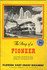
194638206St. Augustine: Private printing 1946. 1946. FLORIDA. 9" x 6" colorful pictorial wrappers. Foreword. 44pp. including wrappers. Black and white map of Florida high-lighting the Florida East Coast Railway from Jacksonville to Miami. Black and white photographs include a portrait of Henry Morrison Flagler the builder of the Florida East Coast Railway Flagler System Hotels and associated enterprises. A pioneer of the East Coast of Florida. "Linking the entire east coast of Florida with a transportation system and establishing tourism and agriculture as the basis of the state’s economy at the time was largely an uninhabited frontier demanded a great deal of foresight and perseverance. More than a century later the mainstays of Florida’s economy are still agriculture and tourism and Flagler’s incredible legacy as the inventor of modern Florida can still clearly be seen throughout Florida." This booklet is well written and provides an interesting summarized history of the Florida East Coast Railway and the development of the area it served. Soiling to wrappers a "Railroadians of America" sticker to front wrapper else a good copy of an informative booklet. Private printing, 1946. unknown
191015233St. Augustness: The Record Company 1910. First Edition. Pamphlet. Near fine. Promotional booklet for Orlando located in Orange County Florida published by The Record Company circa 1910. Oblong octavo 32pp. Publisher's maroon wrappers title printed in gold on cover bound at spine with staples. Sunning to covers staples beginning to rust. A scarce pamphlet showing the local infrastructure farming operations municipal buildings and churches all in half tone illustrations. Illustrations likely by Clarence E. Howard who worked as a photographer and newspaper editor. A reference to the first Automobile Carnival dates this pamphlet prior to 1912. OCLC 882242309 A scarce work. Orlando Florida traces its roots back to the 1830s during a period marked by the Seminole Wars where the U.S. Army built Fort Gatlin south of the present-day Orlando city limits to protect settlers from attacks by Native Americans. By 1840 the area around Fort Gatlin was settled leading to the growth of a small community that by 1856 was known as Jernigan named after the Jernigan family who established the first permanent settlement. The name Orlando was adopted in 1857 though the origin of the name is subject to various legends one of the most popular claims it was named after Orlando Reeves a soldier who allegedly died in the area during the Second Seminole War. The city was officially incorporated in 1875 and by the late 19th century Orlando became a significant hub for Florida's citrus industry. The Record Company unknown
1815267901New York 1815. unbound. 2 pages front and back 13 x 8 inches signed "Ruggles Hubbard" as Sheriff of New York City -- an arrest warrant for two defendants to appear in Mayors Court September 25 1815 in part: ".I Ruggles Hubbard Sheriff of the City of New York do hereby assign the within written Bail Bond to the use of the plaintiff s to be sued for _____ according to the form of the statute in that case made and provided." Evenly toned with usual folds and a minimum of fraying at the borders; very good condition overall.<br/> <br/> New York City Sheriff and adventurer who joined his friend General Gregor McGregor's expedition in conquering Spanish Florida June 29 1817 - December 23 1817 culminating in his appointment as Governor of Fernandina. His six-week reign came to an abrupt end after being overthrown by the notorious pirate Luis Aury who claimed Florida in the name of Mexico.<br/> <br/> unknown
197254577Miami: Florida People's Coalition 1972. Hardcover. Very good. Hardcover. 16. Newsprint paper in tabloid format. Pages tanned as usual with horizontal fold to the middle else very good. Three color "Confront the GOP Convention" centerfod. Possible one shot published to bring attention and funds for the Florida People's Coalition. <br/><br/> [Florida People's Coalition] hardcover
19380086079Miami Beach FL: Davis and Campbell 1938. Hardcover. Very Good. 1938. Hardcover folio spiral-bound in cloth-backed boards. 196 pp. profusely illustrated with b&w photos. Very Good. Rubbing and light soil to the boards; corners worn; faint dampstain to upper corner of the first 10 pages only; otherwise clean and unmarked. A rare book -- OCLC locates only 10 copies. A showcase of the area at its peak includes The Hollywood Beach Hotel Stetson University the Gulfstream Apartments Whitman Kenmore Hotel El Comodoro Miramar as well as sections on Cuba Key West Palm Beach Tampa Winter Haven and many many more. Davis and Campbell hardcover
1831List3518New York City 1831. Two-page printed circular measuring 7 ¾ x 12 ¾ inches with manuscript note from Aaron H. Palmer. Folded with some small tears larger tear at seal not intersecting with text. Overall excellent. Aaron Haight Palmer 1779–1863 was the director of the “American and Foreign Agency for Claimsâ€â€”essentially a high-end collections agency—and later Consul General of the Republic of Ecuador. He was extremely well-connected and his activities included a tour of Europe and Asia to gather information about commerce there for the Rothschilds.1 <br /> <br /> Offered here is an 1831 circular from Palmer’s Agency signed by Palmer and sent to A. Lang Esq. in Selkirk Scotland. The circular advertises the sale of “a large tract of land lying on the Gulf of Mexico in East Florida†which “is owned in sole propriety by Richard S. Hackley Esq. an American citizen.†Hackley 1770–1843 a merchant and later US Consul in Spain had been deeded twelve million acres of land around present-day Tampa by the Duke of Alagon in 1819—who himself had been granted the land by Ferdinand VII in 1817. The circular extols the virtues of the land for sale especially Tampa as “a favorable site for the foundations of a great maritime city†and Chatham Bay’s “proximity to the West India marketsâ€. At the time Florida was in the midst of the Seminole Wars; the Treaty of Payne’s Landing would soon demand that all Indigenous people in Florida leave for Indian Territory. It is not clear what came of Palmer’s attempt to sell Hackley’s land; the latter’s heirs’ claims to his estate were settled in 1908 when the US Supreme Court decided that the Kingdom of Spain had annulled the grant prior to the Adams-OnÃs Treaty giving Florida to the US.<br /> <br /> We find one copy of the circular on OCLC. Of interest to historians of the settlement of Florida.<br /> <br /> 1 Jessica Lepler “‘There is no need for anyone to go to America’: commercial correspondence and nineteenth-century globalisation†Rothschild Archive https://www.rothschildarchive.org/materials/no_need_to_go_to_america.pdf accessed February 12 2026. unknown
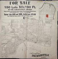
1900List3420Likely Jacksonville Florida 1900. Folded poster on newsprint measuring 16 x 16 inches. With toning stain to top right; very good. A poster published by the C. Buckman Company advertising 50x100 lots in what is currently the Longbranch neighborhood of Jacksonville. The tract is highlighted in red on a larger map of the city. The city saw significant growth during this period from tourism the lumber trade and the expansion of railways. C. Buckman is Courtland Buckman 1863–1952 a lifelong Floridian the son of a Civil War veteran and the brother of Florida State Legislator Henry Holland Buckman for whom the H. H. Buckman Bridge in Orange Park is named. Courtland Buckman was the Deputy County Clerk for Duval County in 1886 and later in the 1880s served one term as the Mayor of Daytona Beach. In 1894 he returned to Jacksonville and joined the C. C. Robertson Real Estate Company before opening his own real estate firm the C. Buckman Company in 1897. He had an active role in the development of Jacksonville and was prominent in business and civic life there including serving on the Jacksonville Board of Trade.1<br /> <br /> 1 Courtland Buckman Papers Thomas G. Carpenter Library University of North Florida Jacksonville Florida. https://archives.unf.edu/repositories/3/resources/17 Accessed January 16 2026. unknown
192140729Washington D.C.: Published by the United States Coast and Geodetic Survey 1921. Large folding nautical chart printed on heavy paper stock. Colored. A rare original coastal survey of the Northern Gulf coast from Florida to Louisiana encompassing Panama City Rosemary Beach Seaside Grayton Destin Pensacola Gulf Shores Mobile Gulfport and the Mississippi Delta.<br/> <br/> Established by President Thomas Jefferson in 1807 as the Survey of the Coast the U.S. Coast and Geodetic Survey was the United States' first civilian scientific agency. This agency has followed its mission to survey the U.S. coastline create nautical charts of the coast and help increase maritime safety since its founding and has often played fascinating roles in significant chapters of U.S. history. It served in all theaters of the Civil War in the service of the Union Army and Navy pioneered acoustic exploration in the wake of the sinking of the Titanic and during WWI it worked to detect enemy submarines. In addition this agency worked to survey and produce detailed maps and renderings of the U.S. coast. These nautical survey maps commonly referred to as "T-sheets" provide fascinating insights into the history of the United States coastline which has and will continue to shift. These maps are the most important data source for understanding the physical and ecological characteristics of the U.S. shoreline. The present map is a highly detailed and accurate sea chart of the Gulf coasts of Florida Alabama Mississippi and Louisiana and an important historical view of the developing states. Published by the United States Coast and Geodetic Survey unknown
191940687Washington D.C.: Published by the United States Coast and Geodetic Survey 1919. Nautical chart printed on heavy paper stock. Colored. A rare coastal survey of the Florida Georgia and South Carolina including Daytona Palm Coast St. Augustine Ponte Vedra Amelia Island Jacksonville Fernandina Jekyll Island St. Simons Sea Island Tybee Savannah Hilton Head Kiawah and Folly Beach.<br/> <br/> Established by President Thomas Jefferson in 1807 as the Survey of the Coast the U.S. Coast and Geodetic Survey was the United States' first civilian scientific agency. This agency has followed its mission to survey the U.S. coastline create nautical charts of the coast and help increase maritime safety since its founding and has often played fascinating roles in significant chapters of U.S. history. It served in all theaters of the Civil War in the service of the Union Army and Navy pioneered acoustic exploration in the wake of the sinking of the Titanic and during WWI it worked to detect enemy submarines. In addition this agency worked to survey and produce detailed maps and renderings of the U.S. coast. These nautical survey maps commonly referred to as "T-sheets" provide fascinating insights into the history of the United States coastline which has and will continue to shift. These maps are the most important data source for understanding the physical and ecological characteristics of the U.S. shoreline. The present map is a highly detailed and accurate sea chart of the coasts of Florida Georgia and Alabama and an important historical view of the developing states. Published by the United States Coast and Geodetic Survey unknown
190840737Washington D.C.: Published by the United States Coast and Geodetic Survey 1908. Large folding nautical chart printed on heavy paper stock. Colored. A rare original coastal survey of the Gulf coasts of Florida Alabama Mississippi and Louisiana including the Keys Fort Myers Sarasota Tampa Panama City Destin Pensacola Gulf Shores Mobile Biloxi Gulfport New Orleans and the Mississippi Delta.<br/> <br/> Established by President Thomas Jefferson in 1807 as the Survey of the Coast the U.S. Coast and Geodetic Survey was the United States' first civilian scientific agency. This agency has followed its mission to survey the U.S. coastline create nautical charts of the coast and help increase maritime safety since its founding and has often played fascinating roles in significant chapters of U.S. history. It served in all theaters of the Civil War in the service of the Union Army and Navy pioneered acoustic exploration in the wake of the sinking of the Titanic and during WWI it worked to detect enemy submarines. In addition this agency worked to survey and produce detailed maps and renderings of the U.S. coast. These nautical survey maps commonly referred to as "T-sheets" provide fascinating insights into the history of the United States coastline which has and will continue to shift. These maps are the most important data source for understanding the physical and ecological characteristics of the U.S. shoreline. The present map is a highly detailed and accurate sea chart of the coasts Florida Alabama Mississippi and Louisiana along the Gulf of Mexico and an important historical view of the developing states. Published by the United States Coast and Geodetic Survey unknown
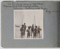
19012885Various locations in Florida 1901. About very good. 16 leaves illustrated with thirty-two original vernacular photographs all 3.5 x 3.5 inches most with manuscript captions in ink above the images. Oblong octavo. Contemporary gray paper wrappers white titles on front cover. Spine mostly split a few shallow chips to edges. Internally clean. A small but important vernacular photograph album containing rare views of the devastation wrought by the Great Fire of 1901 in Jacksonville Florida which took place on May 3 1901. The most destructive event in the history of Jacksonville the Great Fire swept through 146 city blocks destroying over 2000 buildings killing seven people and leaving almost 10000 residents without homes. It is considered the third-largest urban fire in United States history after the Great Chicago Fire and the 1906 San Francisco conflagration.<br /> <br /> The photographs in the present album were taken by an unidentified passenger aboard the Clyde Line steamer Comanche. Eight of the images capture the scene in devastated Jacksonville including a shot of the ruins of the Windsor and St. James hotels shots from atop the "Jacksonville Government Building" a group picture of the city guard "ruins of Jacksonville Court House" "An unknown ruin" a crowded scene at the Jacksonville wharf and a distant shot showing "Ruins of Jacksonville taken from Steamer Comanche May 12." All of the photographs of Jacksonville are dated in manuscript on May 12 1901 nine days after the Great Fire.<br /> <br /> In addition to the Jacksonville pictures other identified locations along the photographer's voyage include the Hillsborough River near Tampa the Tampa Court House scenes around the Tampa Bay Hotel family pictures in Florida the Comanche and its crew Fort Sumter and four views around Charleston. One particularly notable photograph shows six boys standing in shallow water holding fishing nets likely near Tampa. The image is captioned "A group of young crabbers representing three nationalities American Italian and Negro May 10 1901. unknown